Beta testing the forecast this afternoon, but overall it remains on track

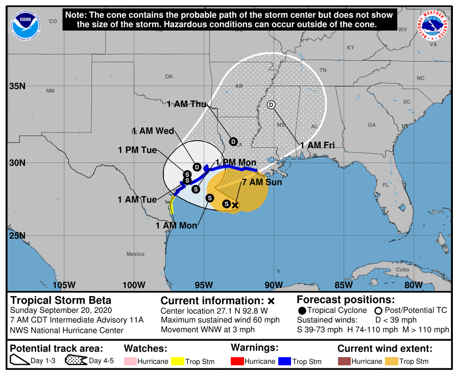
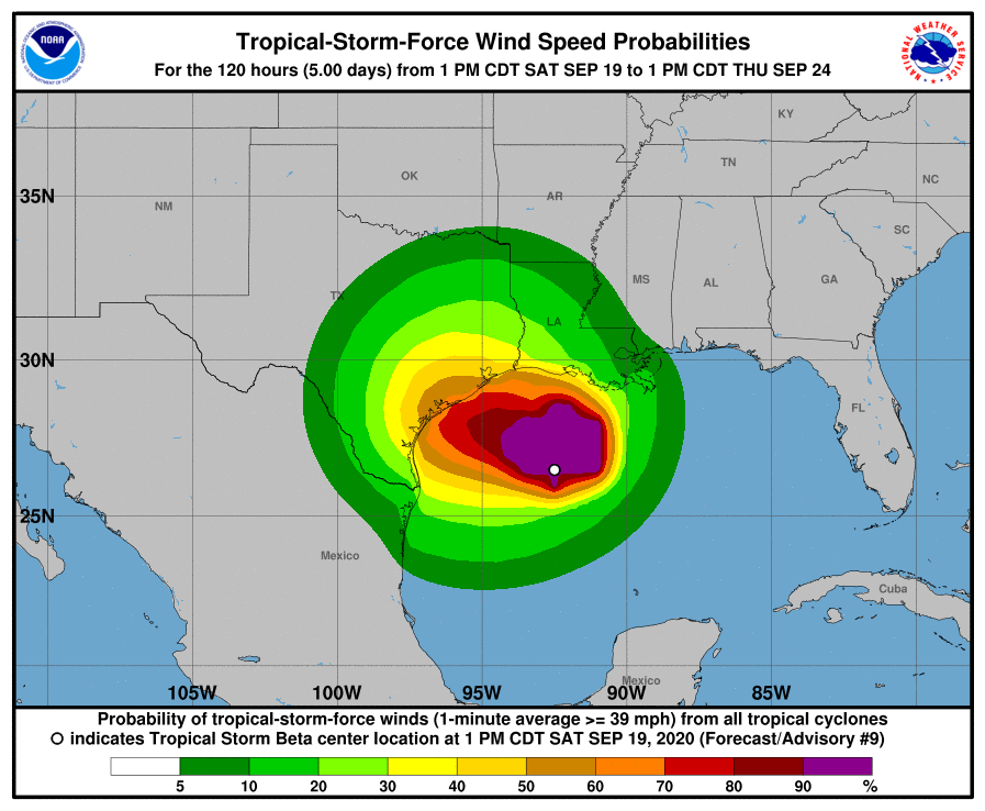
2:30 pm CT Sunday: Our post this morning was sour on Beta. Maybe we trash talked it too much. I don’t know. What I do know is that it looks much healthier than I expected 5 to 6 hours ago, and it’s conceivable that Beta is at least making an attempt to form into a hurricane — temporarily. We still feel that despite the changes in the near-term, the overall forecast ideas we presented earlier today still hold. The area most likely to perhaps see some forecast changes because of what Beta is doing right now would be the Matagorda to Freeport area, which could see some slightly stronger winds or slightly higher surge if Beta does indeed strengthen a bit further.

Beta intensifying?

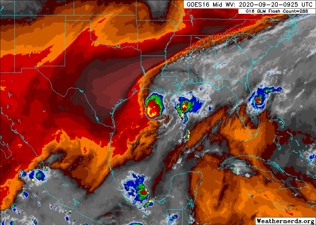
According to the 1 PM National Hurricane Center advisory, Beta still had 60 mph maximum sustained winds, mainly north and east of the center. The reconnaissance aircraft that sampled Beta this morning found ample support for these winds. But over the last 3 hours or so, Beta has clearly begun a burst of intensification.

Beta has clearly improved its structure this afternoon and is likely intensifying a bit. (College of DuPage)

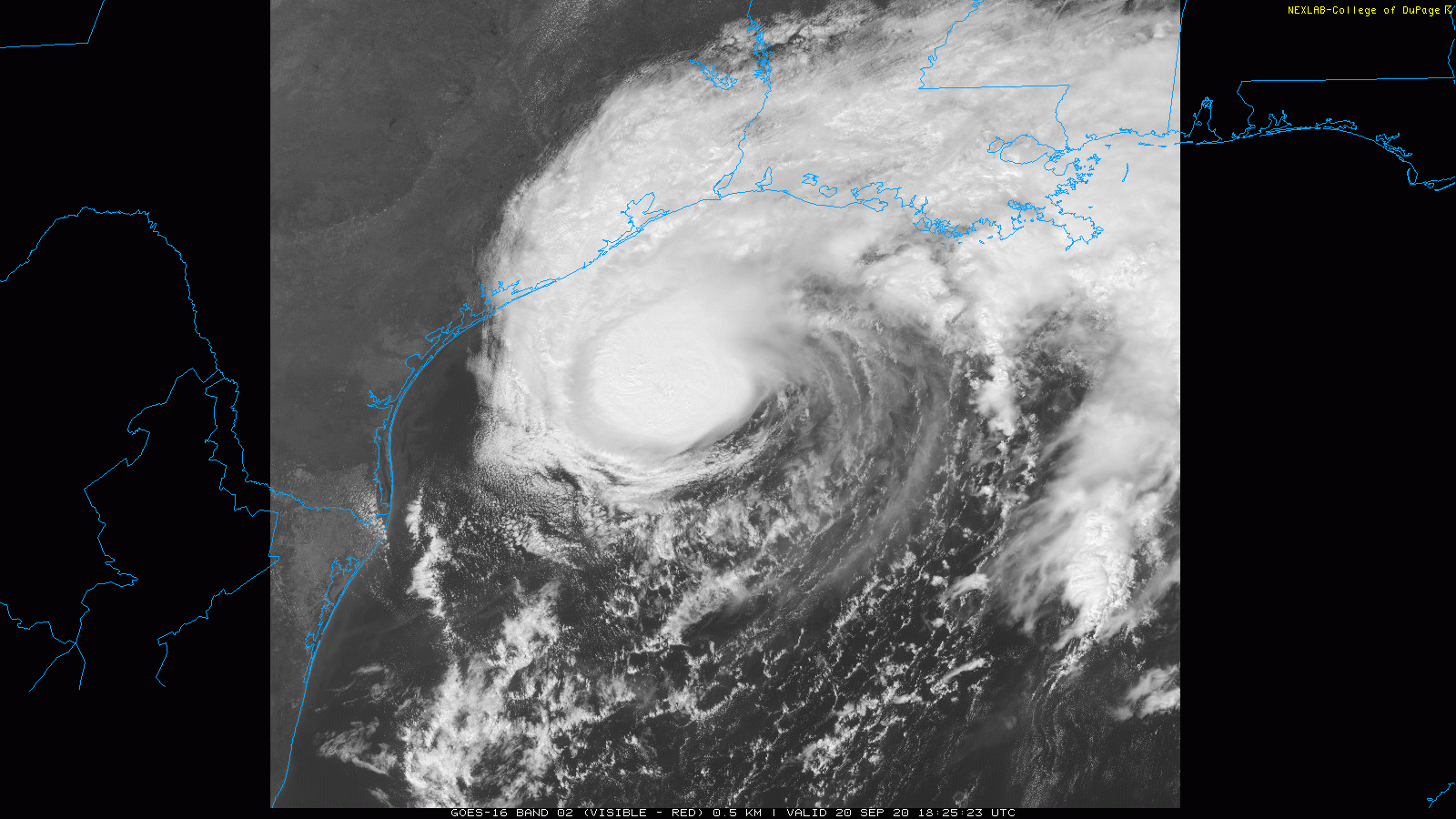
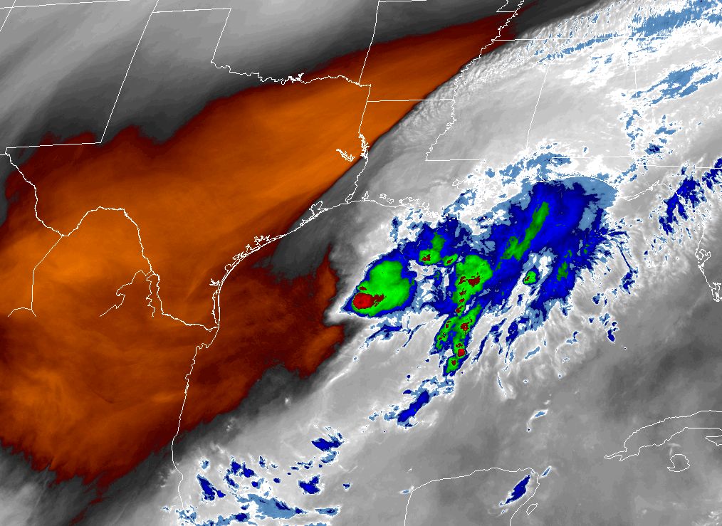
Beta actually looks like a reasonably competent tropical cyclone now. In fact, if you look at radar, you can see a nascent eye-like feature developing. That doesn’t make it a hurricane, but it does mean that it has organized itself, perhaps feeling a brief pause in shear or dry air and the very warm Gulf water it sits over.

Beta has presented an eye-like feature on radar this afternoon. That doesn’t make it a hurricane, but it does indicate strengthening. (GRLevel3)

My guess is that Beta is a strong tropical storm at the moment. But as it approaches the coast, a wall of dry air awaits its arrival. It will be tough to keep that dry air out of the circulation. And the expectation will remain that Beta begins to weaken as it approaches land. That has been the hypothesis since day one, and that still holds true today. The only way that changes is if Beta can insulate its inner core enough from the drier air that is waiting. That’s always a tough call, so we want to continue watching it, but the expectation is that dry air will begin to take a toll on this core later today or sometime tonight.

We discussed our wind forecast expectations in the morning update, and those are unchanged at this time.

Sunday rain

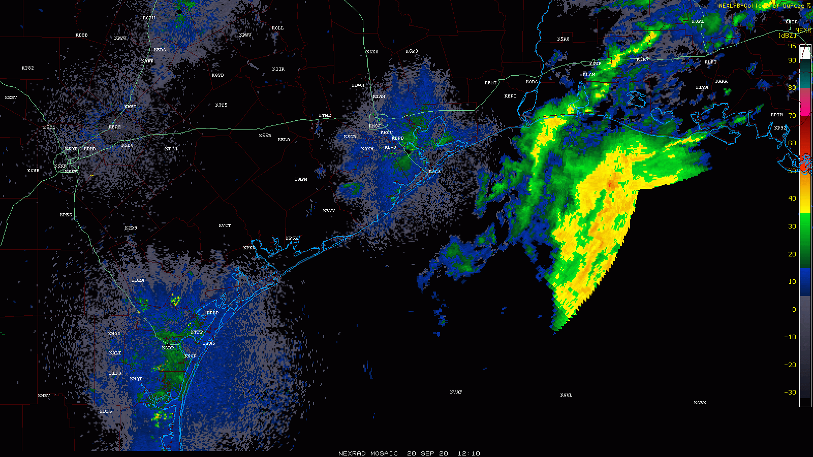
For much of the Houston area, rain has been falling this afternoon, heavy at times. Totals have generally been one inch or less.

Beta’s outer bands are flinging rain, heavy at times, across the area. Most places will end up with less than an inch when this rain tapers off later. (Weathernerds.org)

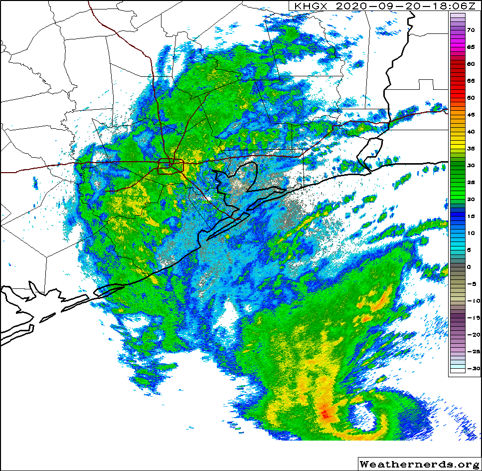
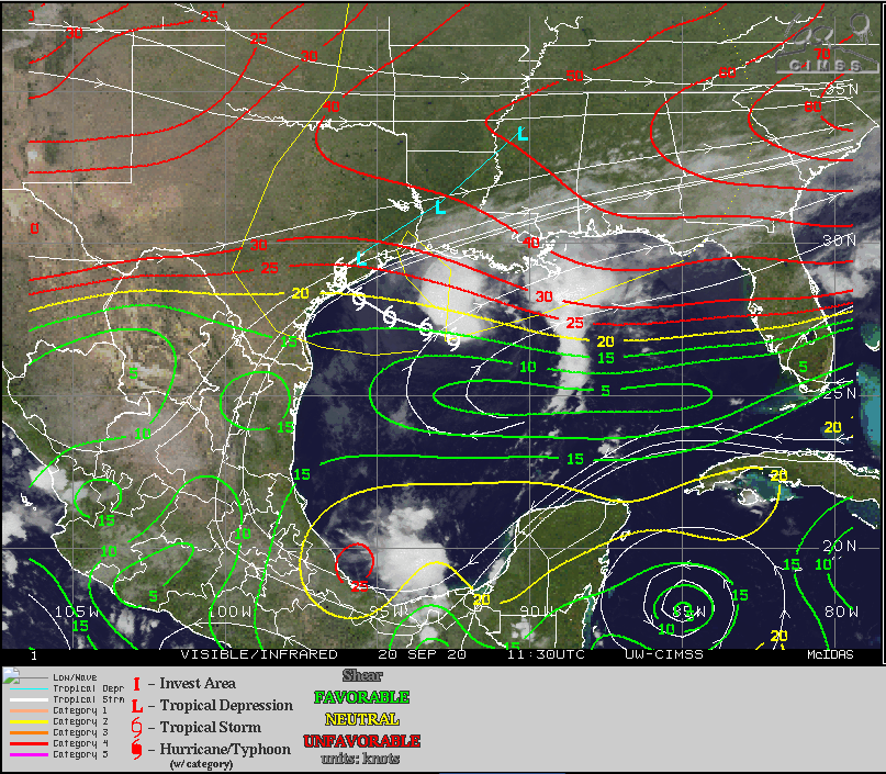
You can see the outer bands of Beta with some heavier rain indicated in yellow on the loop above. This initial wave of rain should taper off a bit later today, but we will likely continue to see gusty showers or even some thunderstorms at times into tonight.

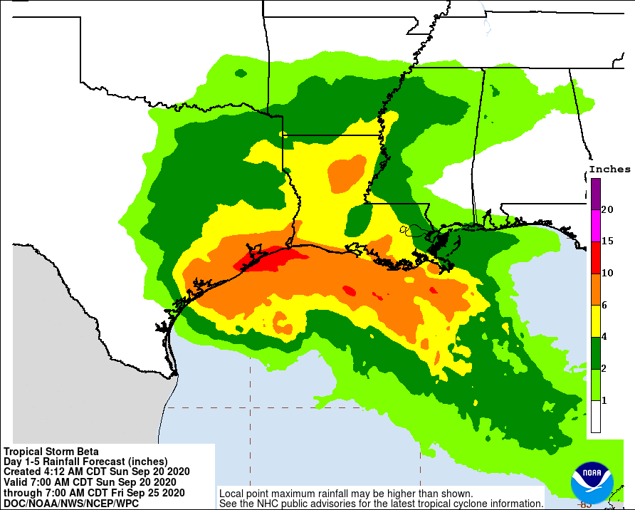
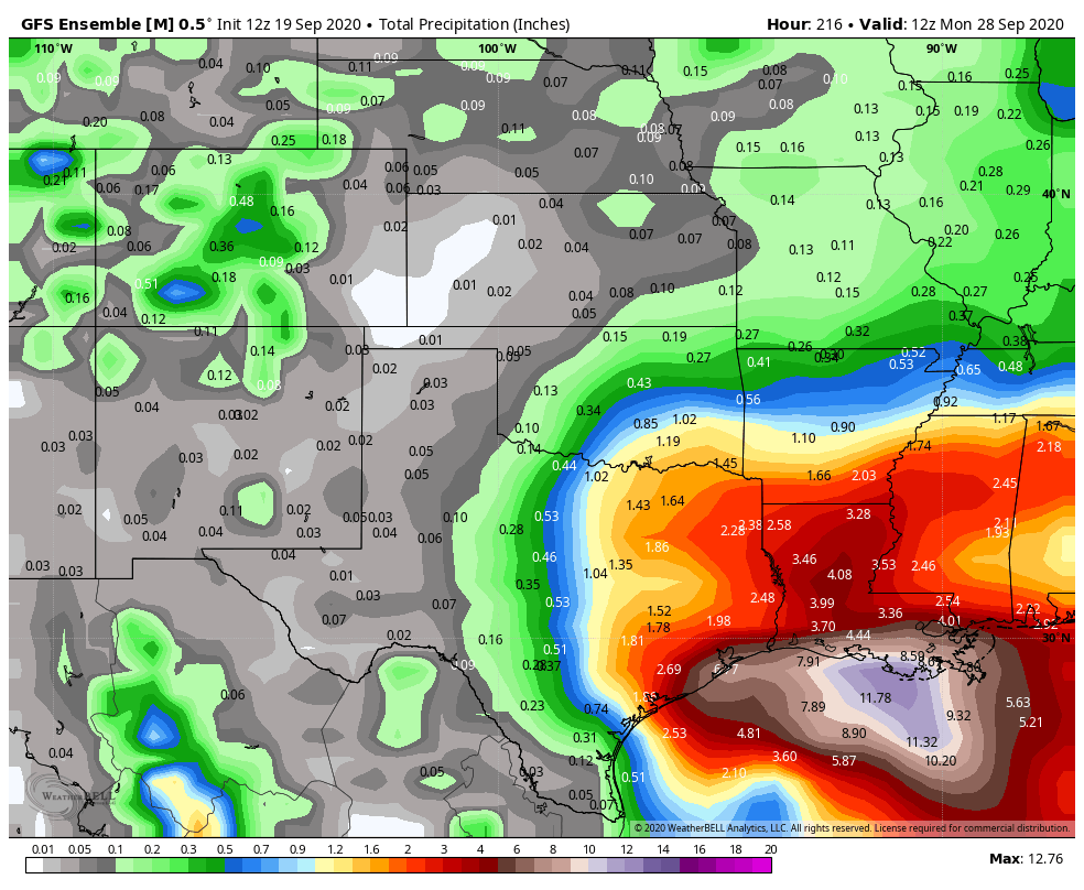
Total rainfall forecast

NOAA has updated their rainfall forecast for the event total, and they have indeed brought values down a little bit further. It looks like they shaved off about 1 inch in Houston to as much as 3 or 4 inches Galveston. Granted, some rain has already fallen, but not as much as has been removed. So, some good news there.

A view of the updated NOAA forecast rainfall from southeast Texas across Louisiana through Thursday evening. (Weather Bell)

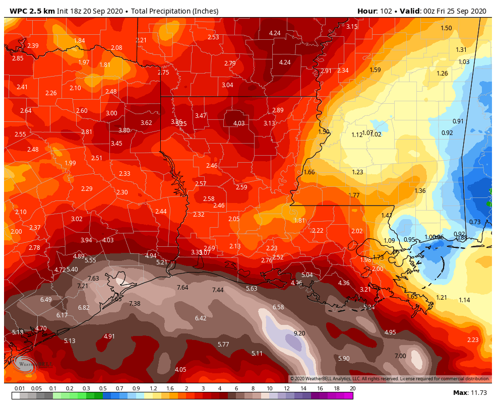
As we’ve been stating, we don’t want folks to just assume this is a non-event; you should remain vigilant in the days ahead. There will be periods of heavy rainfall. But as far as major, widespread flooding, we do not see that scenario as being likely at this time. Still, it may be good to take sensible precautions if you live in a typically flood prone area, particularly with respect to street flooding, just to be safe. In tonight’s update, we’ll offer some thoughts on how Monday’s rainfall may play out.
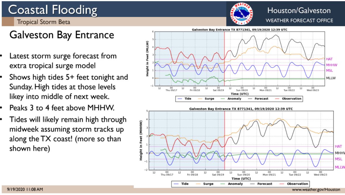
Marine impacts

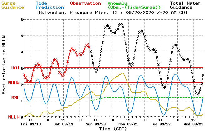
We covered this in depth earlier this morning as well. At Galveston, at the railroad bridge near Tiki Island, we saw about 4 foot water levels this morning. Expect that to be about a foot or so higher tonight and end up in the 5 to 6 foot range.

Tides will be rising again soon in Galveston, which should yield another round of widespread minor to moderate coastal flooding. (NOAA)

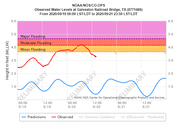
This will cause widespread moderate coastal flooding along the entire coast and bayfronts as well. Expect that to continue much of tonight and Monday morning, with only a slight drop in tides Monday afternoon, followed by a similar peak in tide levels tomorrow night before things subside. This will be aggravated by 8 to 12 foot seas and higher waves offshore.

That’s all for now. Our next update will be posted no later than 9 pm CT on Sunday evening.

Beta drifting toward the Texas coast, mostly status quo this morning

9 am CT Sunday: Good morning. The good news, right off the top, is that we’re basically in the same place with Tropical Storm Beta as we were 12 hours ago. Beta is truly struggling right now, dealing with things from dry air to wind shear, all of which make Beta a very lopsided storm. It’s still capable of causing problems, particularly with marine impacts and rainfall at a localized level, but we don’t see the forecast looking any worse today. And in some aspects, it looks better. Let’s swing through things.

Beta now

We will start by looking at the water vapor satellite loop over Texas and the Gulf this morning. The “drier” colors (dark red, brown, orange) that you see over Texas indicate voluminous amounts of dry air over the area. Go step outside this morning. It’s the driest air we’ve had this early in the day since June 11th in Houston. You can see it on satellite, but more importantly, you can feel it outside.

Using the water vapor channel on satellite can show us copious amounts of dry air over Texas that will work to limit Beta’s intensity. (Weathernerds.org)

That will not help Beta at all. In fact, as Beta moves toward the coast, it’s arguably going to encounter even more of this dry air.

Additionally, Beta is sitting under about 15 to 20 knots of southwesterly wind shear. If you look closely at the map below, you’ll see Beta’s forecast track and the shear values in green, yellow, and red.

The moderate wind shear over Beta has not relented, and in fact, it may get stronger as Beta approaches the Texas coast. (University of Wisconsin CIMSS)

As Beta approaches the Texas coast, Beta’s wind shear situation will not get any more favorable, and in fact, it may get worse, with 20 to 30 knots of wind shear over Texas.

So, all this is to say that Beta is unlikely to get any stronger up to landfall. There is probably even some risk it may weaken a bit.

Beta currently has maximum sustained winds of 60 mph, but those are heavily displaced to the north and east of the center. That said, the wind field radius is 195 miles from the center. For a weak tropical storm, that’s a very large wind field. And this is why marine impacts are such a significant issue. More on that in a second.

Beta track & wind forecast

So we talked intensity above. Expect maximum sustained winds to hold at 60 mph or lower as it slides west toward the Texas coast today and tomorrow. Beta’s center will likely stall near or just inland from where it makes landfall on Monday night and Tuesday before resuming movement, this time off to the northeast on Tuesday night and Wednesday. Beta should be through with us by Wednesday night or Thursday.

Beta will track toward the coast tonight and tomorrow, stalling for a time into Tuesday before exiting Wednesday and Wednesday night. (NOAA)

Beta’s actual winds here in the Houston & Galveston areas will vary. North of I-10, winds will probably never exceed 30 to 35 mph and mostly in gusts. There should be few issues with wind there. South of I-10, winds could gust to 45 mph or so, and there’s at least a chance a brief period of sustained tropical storm force winds (39 mph or higher) is achieved in southernmost areas. Still, problems are expected to be minimal and power outages would probably be isolated in this situation. At the coast and along the bayfronts from Matagorda through Galveston and toward Cameron, LA, wind gusts of 35 to 50 mph will be possible at times as Beta moves in tomorrow. More sporadic power outages and perhaps some minor tree damage could occur in those areas. Overall, wind is not expected to be a serious issue for the vast majority of the region.

Beta marine impacts

The most significant problems from Beta will probably be caused by the marine impacts and the combination of heavy rain and high tides. Highway 87 and Blue Water Highway west of San Luis Pass experienced overwash overnight, and with tides expected to be about 1 to 1.5 feet higher tonight into Monday morning, the coastal flooding situation in those areas will only get worse. We will see tide levels at Galveston around 5 feet or a bit higher.

The tide forecast at Galveston is expected to peak late today and early Monday around 5 feet, and then it should hold in the 4 to 5 foot range (or a smidge higher) into Tuesday. (NOAA)

Coupled with 8 to 12 foot seas, we will see tides only drop slightly during low tide, so this will be a problem for several days with continued minor to moderate tidal flooding along the coast and bays. We should begin to see improvement in these areas by Tuesday afternoon or evening.

Beta rainfall forecast

We conclude with rain, the most challenging part of the forecast. Eric and I are going to maintain our flood scale posture of Stage 2 south of I-10 and Stage 1 north of I-10.

Weather models are generally poor at forecasting rain amounts with specificity and exact location, but the one trend that has been undeniable since yesterday has been to take heavier rain on the Texas coast and offshore and shift it more to Louisiana. The current rainfall expectations from NOAA still show high amounts on the coast.

NOAA’s forecast of total rainfall has dropped considerably since yesterday but remains high enough to warrant Flash Flood Watches. (NOAA)

These amounts are down pretty substantially from yesterday, however, now with 10 to 15 inches expected along the coast and 4 to 10 inches of rain in the Houston metro over the next five days. If these change further later today, I believe it will be to shift some of the higher totals more into Louisiana.

That said, this remains a very difficult and challenging rainfall forecast. For today, expect rain bands to begin to pivot into our area. Rain is already approaching Bolivar and Winnie and expect that to continue coming west today.

The outer bands of Beta’s core will begin to approach the coast this morning and afternoon. (College of DuPage)

As we go into tonight, look for continued squally weather with periods of heavy rain and thunderstorms at times, especially south of I-10. We don’t feel that this will be a continuous rain event for the area, but it will come in bursts at times. This is generally good for bayous and creeks to be able to handle the rainfall without a ton of serious trouble. Where this could get a little more bothersome is if the core produces some heavy rain as it moves ashore tomorrow or Tuesday, especially south and west of Houston. That would be the most likely time we see rainfall rates that could cause some issues. But as of now we feel that for the most part the area can handle what is being thrown at it this week. Beyond Monday and Tuesday, there’s still some uncertainty, but pockets of rain are likely and in small areas (size-wise, think over like a couple communities or so) we could see heavier downpours and some more troublesome flash flooding. We’ll be watching all this closely and update you through today and tomorrow and beyond on any changes in potential or any ways we can get more specific about where heavier rain will fall.

In the meantime, we will have our next post no later the 2:30 pm CT Sunday afternoon.

Beta impacting the coast already, but we still have questions about rain

8pm CT Saturday: We’re still in wait-and-see mode with Tropical Storm Beta, which remains nearly stationary in the northwest Gulf of Mexico this evening. Here are our key takeaways this evening:

  • Beta is fighting dry air, and moderate westerly shear. It still has the potential to strengthen, but the National Hurricane Center no longer expects Beta to become a hurricane before approaching the Texas coast, likely near Matagorda Bay, on Monday or Tuesday.
  • Water levels along the Texas coast in places like Crystal Beach and the west end of Galveston Island are starting to rise in response to Beta, and the storm may inundate low-lying areas for a few days. Final preparations should be taken along the coast soon.
  • Beta still poses a significant flooding risk to Texas and Louisiana that we need to take seriously. But we have lots of questions about this, and unfortunately no good answers right now. We’ll discuss this more below.

Flood chances

So this is a difficult one, and you’re going to have to bear with us while we suss out an accurate forecast. As a tropical storm, Beta definitely has the potential to bring a lot of rainfall to the Texas coast, and that is our primary concern. However, we do not think that is a slam dunk.

You may have seen the five-day rainfall forecast that the National Hurricane Center released with its 4pm CT package this afternoon (shown below). The totals are rather eye catching. This forecast seems to be a bet that because Houston will lie in the northeastern quadrant of Beta as it makes landfall and moves inland, that our region will see very heavy totals.

Estimated rainfall forecast for now through 7pm CT Thursday. (NOAA/WPC)

Yep, this shows a solid 15 to 20 inches along the coast, and a band of 10 to 15 inches across the Houston metro area. This is what you would expect from a typical tropical storm following Beta’s track.

However, there are several ways in which this forecast could go bust. One is that Beta moves far enough inland into Texas early next week that it gets cut off from a moisture supply. Two, Beta is going to be fighting dry air to its west, and this may starve the convection near the storm’s center, which would lessen rain totals along the Texas coast. Finally, we could see the heaviest remains far removed from the center. This is the scenario depicted in virtually all of the global model guidance, both their operational runs and ensemble outputs. Nearly all of this guidance suggests five-day rain totals of 2 to 8 inches across the greater Houston metro area, including Galveston. These models do not do a good job of picking up small-scale convective processes, but there is a strong signal here that is hard for us to ignore.

So what is our advice? We think the NOAA precipitation forecast offers a reasonable “worst case” scenario for rainfall, but we also think there is a reasonably high chance of a bust. We are not going to have the final answer on this for at least a day or two longer.

Coastal impacts

Water level rises along the upper Texas coast have begun today, and will worsen Sunday into Monday as Beta eventually moves closer to the state. Beta’s winds will drive large swells over the Northwest Gulf of Mexico by Sunday into Monday, which will bring waves on top of a storm surge of 2 to 4 feet along the Galveston and Bolivar beaches. This will flood low-lying areas, including Highway 87. Coastal flooding will also be possible in El Lago, Nassau Bay, Shoreacres, Seabrook and portions of Baytown.

Probability of Tropical Storm-force winds over the next five days. (National Hurricane Center)

The current estimate is that there is about a 50 percent chance of sustained tropical storm-force winds along Galveston Island and southern Brazoria County. However, there are real questions about whether Beta is going to be able to battle moderate shear and dry air to intensify further than its 60-mph sustained winds as it moves toward Matagorda Bay, further down the coast. Along this track, we do not anticipate widespread power outages due to downed lines in Galveston or Houston.

So that’s what we’ve got tonight. Matt will have our update no later than 9am CT Sunday.

Tropical Storm Beta turns west toward Texas: Be wary, but not overly worried

2pm CT Saturday: Tropical Storm Beta made its expected turn west earlier today and is now crawling toward the Texas coast at 2 mph, according to the National Hurricane Center. Its maximum sustained winds are 60 mph. Our overall forecast for the Houston metro area has not changed at this time: We still anticipate Stage 2 flood conditions south of Interstate 10, and Stage 1 for areas north of Interstate 10. Bottom line: We have not seen anything today that makes us any more concerned.

I want to start with a satellite image of the Gulf of Mexico this afternoon that illustrates water vapor—a good proxy for convection. When you look at this image there are a couple of important things to notice. One, the precipitation associated with Beta is strongest near its core and well to its east. Second, the reddish hues across Texas indicate dry air. Some of this dry air is wrapping into the circulation of Beta, which is helping to hamper its intensification. Finally, it’s clear that until Beta moves further west the bulk of its precipitation is going to fall over the Gulf, or southern Louisiana.

Water vapor satellite image for Beta on Saturday afternoon. (NOAA)

In this afternoon post I want to discuss the timing of what to expect after today, and when. The usual caveats apply, this is a dynamic weather system, so forecasts will change. But this is our best guess as of 1:30pm Saturday afternoon.

Sunday

Beginning fairly early on Sunday we could see some outer rain bands from Beta moving into the Texas coast. Most likely these will be light to moderate, at least during the daytime hours. Coastal areas may see upwards of 1 to 2 inches of rain, but inland areas will likely see less. All in all, this should not be too disruptive. Coastal areas may see tides 3 to 4 feet above high tide levels, particularly on Sunday evening, and Monday morning. Tropical Storm force winds may arrive along the coast, from Matagorda Bay to Galveston by Sunday evening or during the overnight hours.

Monday

Most of the best available model guidance suggests we will see similar conditions on Monday as the storm’s center nears the Texas coastline, probably near Matagorda Bay. I should note that overall confidence in this track remains somewhat low, and that a northward jog in the track would bring more serious winds and surge into Galveston Bay. However, we don’t expect that right now. Beta will likely will be a high-end tropical storm or a low-end Category 1 hurricane at this time. Winds will probably increase across the Houston area, although I’m not sure they will reach Tropical Storm-force.

Coastal flooding outlook for Galveston. (National Weather Service)

Tuesday and Wednesday

These are the days when we can probably expect the heaviest rainfall, although amounts are still to be determined. This is the period when we expect Beta (or the remains of Beta) to begin lifting to the north and then northeast, perhaps bringing its circulation near the Houston metro area. By Thursday we should see improving conditions across Texas.

So really, how much rain?

If you remember the satellite image at the top of this post, almost all of the convection and strong storms lay to the east of the storm’s center. We think that the most likely scenario is that this pattern continues during the coming week, and we end up with a situation where most of the Texas coast north of Corpus Christi sees 4 to 12 inches of rain over the next week, with lesser amounts inland. This is very general, ballpark value. The key thing to remember is that this scenario would not lead to widespread, catastrophic flooding.

12z GFS ensemble forecast (shown) and other recent models indicate most precipitation will be offshore. (Weather Bell)

However, we cannot discount the possibility of Beta really getting its act together over the next day or two, and becoming a prodigious rainmaker over Texas. In this reasonable worst-case scenario, areas from Matagorda Bay to Galveston to Beaumont are at risk for 20 inches or more of rain, with 10-plus inches for parts of Houston. That is the high-end risk. But again we do not favor that scenario right now; and if our view changes we will let you know post-haste with a hasty post.

Our next update will come no later than 8pm CT this evening.