Good morning! Houston weather will be doing Houston things for the rest of this week, which means you can expect our customary heat and humidity. But given that our weather will neither be exceptionally hot or exceptionally wet in the days ahead, we’ll take that and be happy in August.
Tuesday
This will be another day a lot like Monday, with partly to mostly sunny skies. Winds will be light, at only about 5 mph, out of the west. This should allow high temperatures to nudge up into the mid- or possibly even upper-90s for areas well inland, while remaining several degrees cooler near the coast. As temperatures rise into the 90s, we may see the development of isolated to scattered showers and thunderstorms north of the metro area, sagging southward into Houston during the late afternoon or early evening hours. Rain chances are likely about 30 percent, or a tad less.
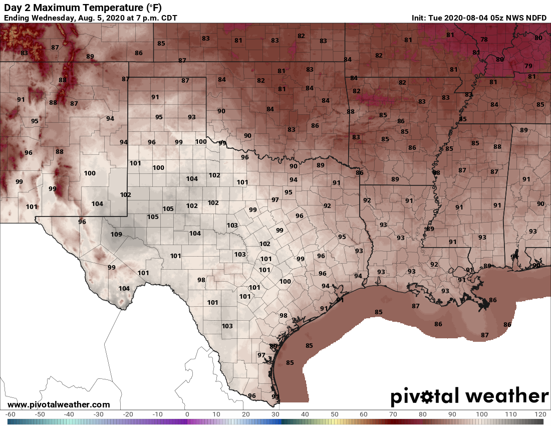
Most of Texas will be in the 100s by Wednesday, but the Houston area should remain in the mid-90s. (Pivotal Weather)
Wednesday
Expect more of the same conditions as Tuesday, with mostly sunny skies and highs generally in the mid-90s. We will again see a chance for the development of some briefly lived, south-moving showers and thunderstorms in the late afternoon. As will be the case for most of this week, nighttime lows will barely drop into the 70s for most of the region, with partly cloudy skies. Humidity will be ample, of course.
Well Houston, we’ve made it to the start of August. Historically this is the hottest, steamiest month of the year, when the average high is 95 degrees, and the average low 75. I look at it like this: If you’re in Houston in August and the high temperature is not in the upper 90s or higher, the streets aren’t flooding, and you’re not concerned about an impending hurricane—it’s a win. August is a month to survive, with the promise of better weather down the road. And hey, two days are already down!
Monday
Some surprisingly robust storms developed north of Interstate 10 on Sunday, and although the atmosphere is slightly less favorable today, we may see some additional development over inland areas this afternoon that moves southward toward I-10. This would start up during the warmest part of the day, with highs in the mid- to upper-90s, and potentially combine with the sea breeze. These isolated to scattered thunderstorms could produce briefly heavy winds and rains through the evening. Skies, otherwise, should be mostly sunny, with calm winds providing no relief during the hottest part of the day. Overnight lows will likely drop into the upper 70s.
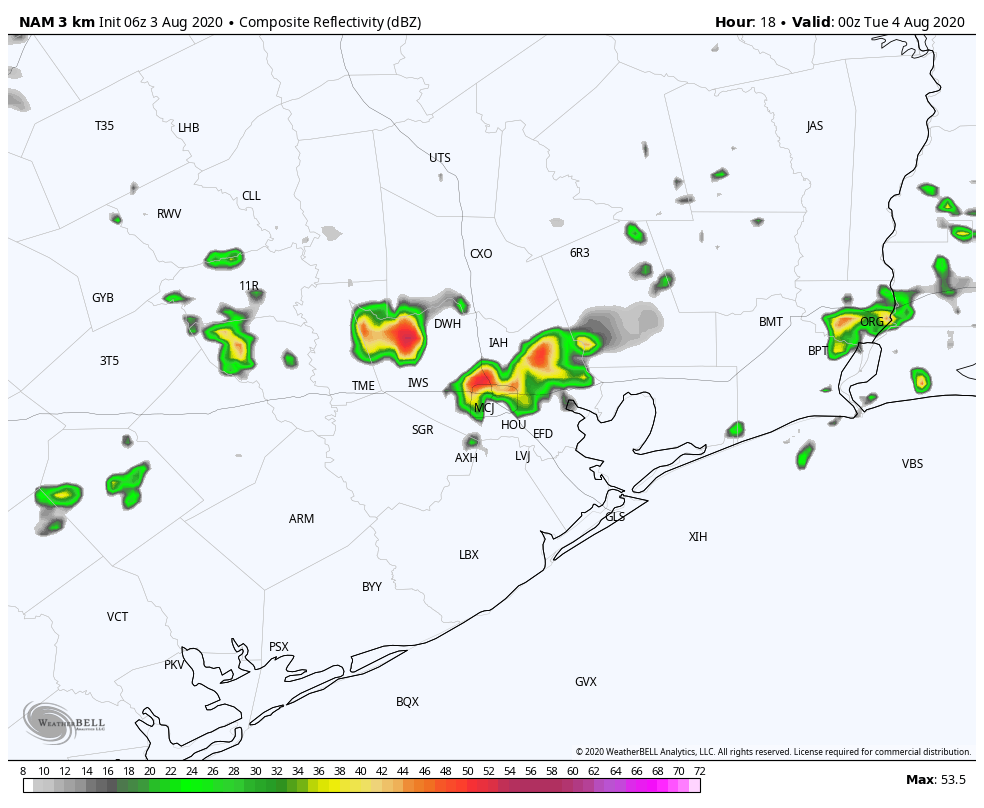
NAM model shows potential some development across the area at 7pm CT Monday. (Weather Bell)
Tuesday
This should be a day similar to Monday, that starts out with sunny skies, but then sees development of storms during the hotter part of the day. Again, aerial coverage should be about 30 percent. High temperatures will likely reach into the upper 90s for inland areas, and a few degrees cooler along the coast.
In summertime, few things are coveted more in Houston than a cold front, and as we flip the calendar from July to August, we’re going to get just that. Now, don’t get too excited. It is not really going to translate into opening the windows and letting the gloriousness flow.
It’s not going to feel quite this nice this weekend, unfortunately.
Rather, this will probably bring us some rain chances, perhaps some strong storms today, and maybe a tinge less humidity than we’ve had late this week. But beyond that? Not much. We never really, truly cool off. Let’s go through the details
Today & tonight
For the most part, today looks fine. Expect a mix of sun and clouds, along with very hot weather. Look for mid-90s and high humidity. Rain chances in Houston and points south should be confined to primarily just a passing downpour. During the afternoon, we expect showers and storms to fire up between Dallas and Huntsville. Those storms will drop into the northern third of the metro area by late afternoon, with places like Conroe or The Woodlands or northwest Harris County standing the best chance at storms before 5 to 7 PM or so.
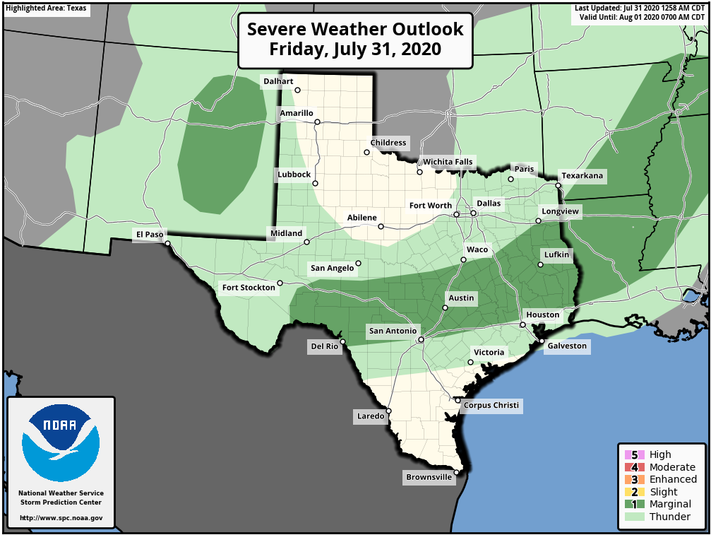
The Storm Prediction Center has areas north of Houston in a “marginal” (1/5) risk for severe weather today. Any severe storms should be fairly isolated. (NOAA)
Storms today do have the potential to be strong to severe, but we don’t expect widespread severe weather or anything like that.Strong, gusty winds and hail would be the main risks from the strongest storms.
The front will slip into metro Houston tonight. The strongest storms should begin to ease up a bit after sunset, but we wouldn’t be shocked to see some noisy storms with locally heavy rain moving through the I-10 corridor and just south through late evening and toward midnight. We should see storms generally dissipate after midnight, but if they were to continue going, it would areas south of Houston most likely to see them.
Saturday
With showers and storms generally expected to diminish overnight, we think Saturday will start mostly quiet. However, if there are some morning showers or rumbles of thunder, they would likely be close to the coast or well south of Houston toward Matagorda Bay.
I have to be honest here: Given recent model performance of late, there is still see some uncertainty in exactly how things may transpire tomorrow. But in general, look for some additional showers and storms to fire up along what is left of the cold front south of Houston (Brazoria, Matagorda, Wharton, and Jackson Counties most likely) before it dissipates. Additionally, there could be some storms that fire to the west of Houston Saturday afternoon, perhaps near the Katy area north toward Waller and Grimes Counties.For the city of Houston and points north, much of tomorrow could be a quiet and fairly pleasant summer day. But I would not place rain chances at zero. Highs will be in the low-90s with morning lows in the 70s.
Sunday
Sunday’s forecast is a bit tricky as well. The front should have basically lost any definition and fallen apart by Saturday night and Sunday morning. But there will likely still be enough of a “trigger” for thunderstorms around. However, with atmospheric moisture generally on the wane, we suspect Sunday’s storm coverage and rainfall intensity will be less than we see on Saturday. All that said, I would probably take a more pessimistic stance on Sunday than what models are explicitly showing right now (which isn’t very much in the way of rain). So let’s expect scattered storms and hope for better on Sunday.
Sunday’s high will top off in the low-90s with storms, mid-90s with only a handful of them, and we’ll see morning lows in the 70s.
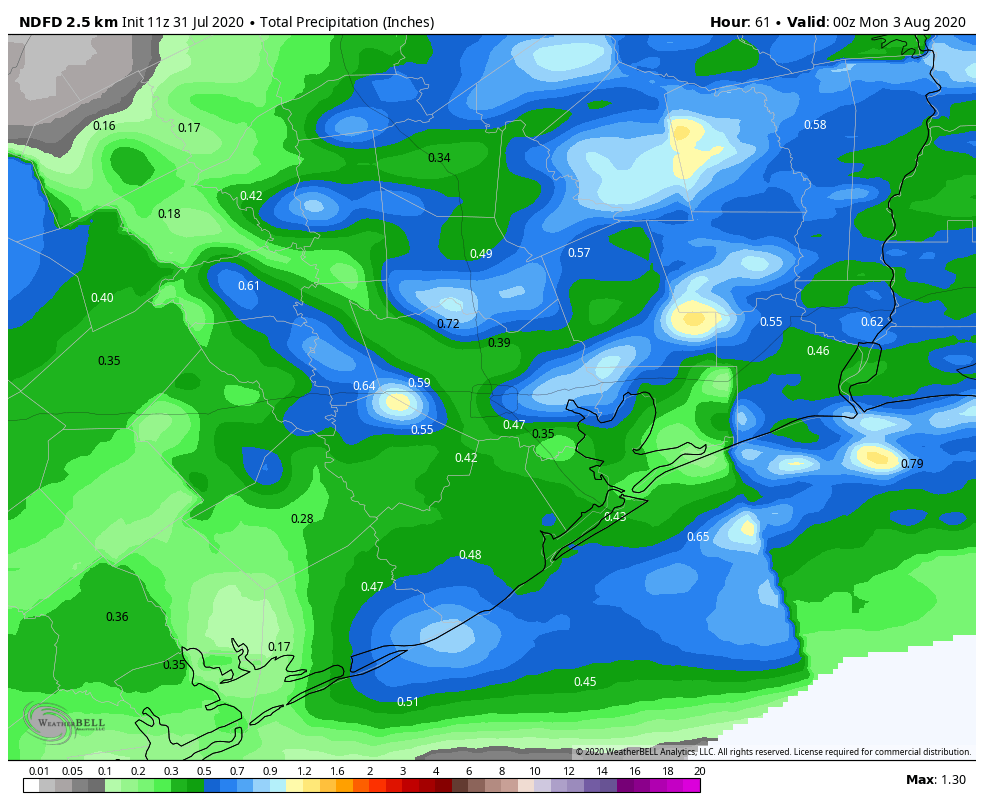
Rainfall this weekend will be erratic, with some folks seeing little to no rain, others perhaps seeing a couple inches, and many seeing something in between. This map gives you an idea of where the heaviest is currently expected to fall, though that could change. (NWS via Weather Bell)
Total rainfall this weekend? Some may see locally heavy rain that could add up to an inch or two or even more. Others may not see much of any rain at all. And still more of us will see something in between, closer to a tenth or quarter-inch. The map above should just give you a rough idea of where the heaviest rain could fall.
Good morning. After several wetter days for the region, rain chances will slacken some to end the work week before returning again Friday night. As we head into August this weekend, high temperatures will likely remain mostly in the low 90s, which is fairly “pleasant” for what is typically the hottest time of the year in Houston.
Thursday
Some drier air is mixing into the atmosphere this morning, and this should help to limit shower and thunderstorm activity later today across the region. Rain chances are likely around 20 percent for most locations. Skies should become partly to mostly sunny this afternoon, and this will allow highs to warm into the low or mid-90s for the region. Winds, generally, will be light, coming from the south. Skies should turn partly to mostly cloudy tonight, leading to warm and humid conditions, with lows struggling to fall below 80 degrees for much of the region.
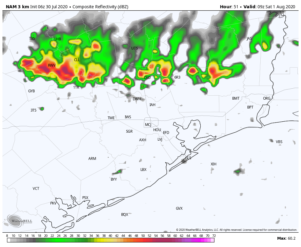
NAM model forecast shows potential of storms developing early Saturday morning. (Weather Bell)
Friday
Conditions will be similar on Friday, with partly to mostly sunny skies leading to another warm day with highs in the low- to mid-90s. Later in the day a dying cool front will approach the region from the northwest. This may ultimately bring some drier air into the northern half of the metro area, but initially it may lead to some storms over areas north of Interstate 10—particularly Austin, Waller, Washington, Grimes, and Montgomery counties. Some models indicate a line of storms moving into these areas between midnight Friday and Saturday morning. We’ll continue to track this to see if it’s likely to come to fruition.