Severe Thunderstorm Watch & hail risk through Wednesday evening

Storms have exploded northwest of Houston today with numerous reports of large hail, up to as big as golf ball size or larger. As I write, this large hail is possible near Bryan in the Brazos Valley.

Radar shows strong and severe storms in the Brazos Valley racing southeast toward the Houston area this afternoon. (College of DuPage)

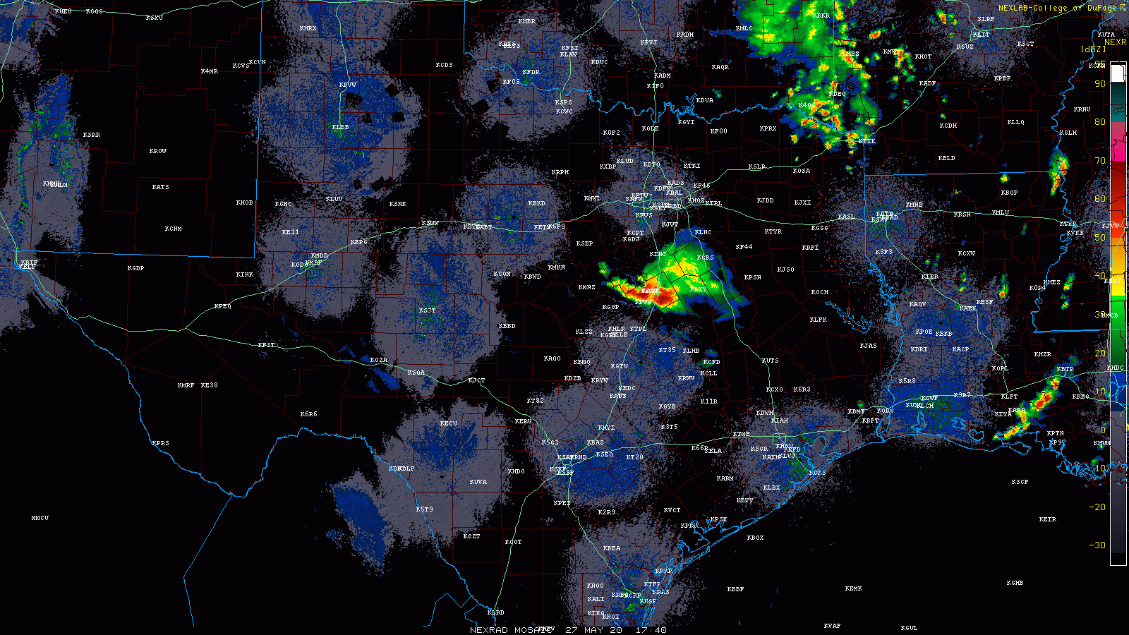
As a result of this, a Severe Thunderstorm Watch has been hoisted for the entire Houston area through 9 PM this evening. The main threat will be between now and 6 PM I think, however. These storms near Bryan-College Station are hauling south and east around 20 to 30 mph, and new storms are trying to blossom out ahead of them.

The main threat from today’s storms is likely to be large hail. Not everyone will see hail, but those that do (most likely along and north of I-10) could see hail to the size of golf balls or even a little larger. The hail threat today is legitimate. A secondary threat will be strong winds, capable of knocking down trees or power lines in spots. A very small tornado threat is there, but it’s not especially high at this time. We’re focused on hail and wind today I think. Heavy rain is also possible from any of these storms.

While the severe threat should fizzle after sunset, we may see additional rounds of showers or even some thunderstorms into later this evening. We’ll update again if things look more significant. But please stay weather aware through this afternoon and evening.

Storms possible today and Thursday before a fine late-May weekend

Good morning. The Houston area is sailing toward fairer weather—this weekend looks hot and sunny—but before that time we’ll face a couple of days with fairly healthy rain and thunderstorm chances. Also, with the school year ending, Matt and I will be convening our final Wednesday Weather discussion on Facebook at 10am CT today. Please join us. I’ll post a link to a YouTube version tomorrow morning if Facebook is not your thing.

Wednesday

Conditions this morning are quite fine for late May, with clear skies and temperatures lower than normal. Conroe got down to a spectacular 60 degrees with the region’s slightly drier air. However the sunshine is unlikely to last for most of Houston. Even though an upper-level level low pressure system is moving away from us, it should help pull an atmospheric disturbance into the area. What we think probably will happen is the development of storms west or northwest of Houston sometime this afternoon.

NOAA severe storm outlook for Wednesday.

These storms will then sag and then (maybe?) weaken as the slide into the city during the late afternoon, evening, and overnight hours. NOAA’s severe weather outlook shows the higher risk to the west of Houston, with the threat of strong winds and hail. Rain accumulations will be less than half an inch for most, but areas under heavy thunderstorms will get more. Until storms develop today expect mostly sunny skies with highs near 90 degrees.

Thursday

A similar pattern could set up Thursday, with partly sunny skies in the morning giving way to the potential for storm development during the afternoon. This may be aided by the passage of a weak front—hard to call it a cold front as there won’t be much cooler air. Rain chances are around 50 percent for the region, with highs again going up to around 90 degrees.

See full post

All in all, the last week of May should be pretty nice

Good morning. Moderate to briefly heavy rainfall moved through the Houston area during the overnight hours, generally dropping between 0.25 and 1 inch of rain. This looks to be the last of our organized storm systems for awhile, although our region will certainly face the possibility of scattered showers and thunderstorms this week. But overall, the last week of May 2020 will be reasonably pleasant weather-wise, with slightly lower humidity than normal. Enjoy this, friends, because June is around the corner.

Tuesday

The remnants of the overnight rainfall system are pushing through Houston this morning, and should move out by 8 a.m. or 9 a.m. Skies should be partly to mostly cloudy today, with the possibility of additional scattered showers this afternoon. Highs will reach the mid-80s. You may notice winds start to come from the north later today, and this will give us shot of slightly drier air that may linger for most of this week. It should be especially noticeable this evening, and on Wednesday morning when lows drop into the 60s for most areas except the coast.

Low temperatures outside of Houston look quite pleasant on Wednesday morning. (Weather Bell)

Wednesday

The much discussed upper-level low pressure system should continue to wobble away from the region on Wednesday, and this should lead to partly to mostly sunny skies. This, in turn should allow for temperatures to push into the upper 80s, and this daytime heating may trigger a few afternoon showers. Lows Wednesday night should be a few degrees warmer than Tuesday. It’s possible we may see some additional showers late Wednesday night into Thursday morning, but I don’t have overly high confidence in this.

See full post

Expect a lull in storms on Memorial Day before more rain overnight

On this Memorial Day, when we remember those who died serving our country, we both literally and figuratively have a cloudy forecast. Strong thunderstorms raked northern parts of the metro area on Sunday afternoon and evening, and then another line of storms moved through much of Houston this morning. Some areas in east Houston near the Sam Houston Tollway received nearly 5 inches of rainfall, all told. The result of all this is that, as of this morning, the atmosphere has somewhat stabilized.

Accordingly, we expect mostly cloudy skies for most of Memorial Day, with highs pushing into the mid-80s later this afternoon. It’s possible that some areas may see a break in the clouds later today, but for the most part the Sun should be hidden. Our best guess is that rain showers will be scattered to non-existent during the daytime with the atmosphere calmed down.

Pretty much all of Texas will likely see a wet Memorial Day, or Memorial Day night. (Pivotal Weather)

However, at some point during the overnight hours or on Tuesday morning it seems like conditions aloft will become stabilized. Therefore we could see another disturbance push through the region like what happened early on Monday morning—a broken line of showers and thunderstorms bringing another one-half inch of rain or so to most people.

For the remainder of the week, Houston’s weather will remain subject to the whims of a meandering upper-level low pressure system. For now it appears as though Houston will be wet at times this week, but we’re not anticipating anything too extraordinary. So while we’re vigilant about the flooding potential this week, we don’t see any signs of anything beyond some short-lived street flooding—for now at least.