Our blah weather will continue for several more days before a front brings a reprieve next weekend. Expect foggy mornings, cloudy days, and warm nights to persist through Saturday before a merciful front works its way into Houston.
Tuesday
It is quite foggy this morning, and the National Weather Service has issued a dense fog advisory until 10 a.m. due to low visibility. Please take care driving in these conditions. On Monday, showers were most pronounced near the coast, but today they will move farther inland. Beyond that, I have little confidence in rain totals today. Some models show almost no rain over Houston, while some bring up to 2 inches in places like Baytown. I don’t think we’ll see that, but it’s going to be a gray day with a healthy chance of showers. Highs are going up into the mid- to upper-70s, with low in the upper 60s. Like I said, blah.
The only good thing I can say about Wednesday, which will be gray and warm, is that rain chances are quite a bit lower—in the 10 percent chance. Fog remains likely, however, with very light winds and warm air moving over colder water.
Thursday
More of the same. Rain chances will edge back up a bit, but at this point we’re not expecting anything to write home about. A cold front will approach the area, but probably stall north of the area on Thursday. Right now, it appears the front will get to about the northern edge of Montgomery County before retreating quickly back north. Bottom line, there’s a chance of some briefly drier and cooler air to make it into northern parts of the region. For the rest of us, you guessed it: Highs in the upper 70s, clouds, fog, and warm nights.
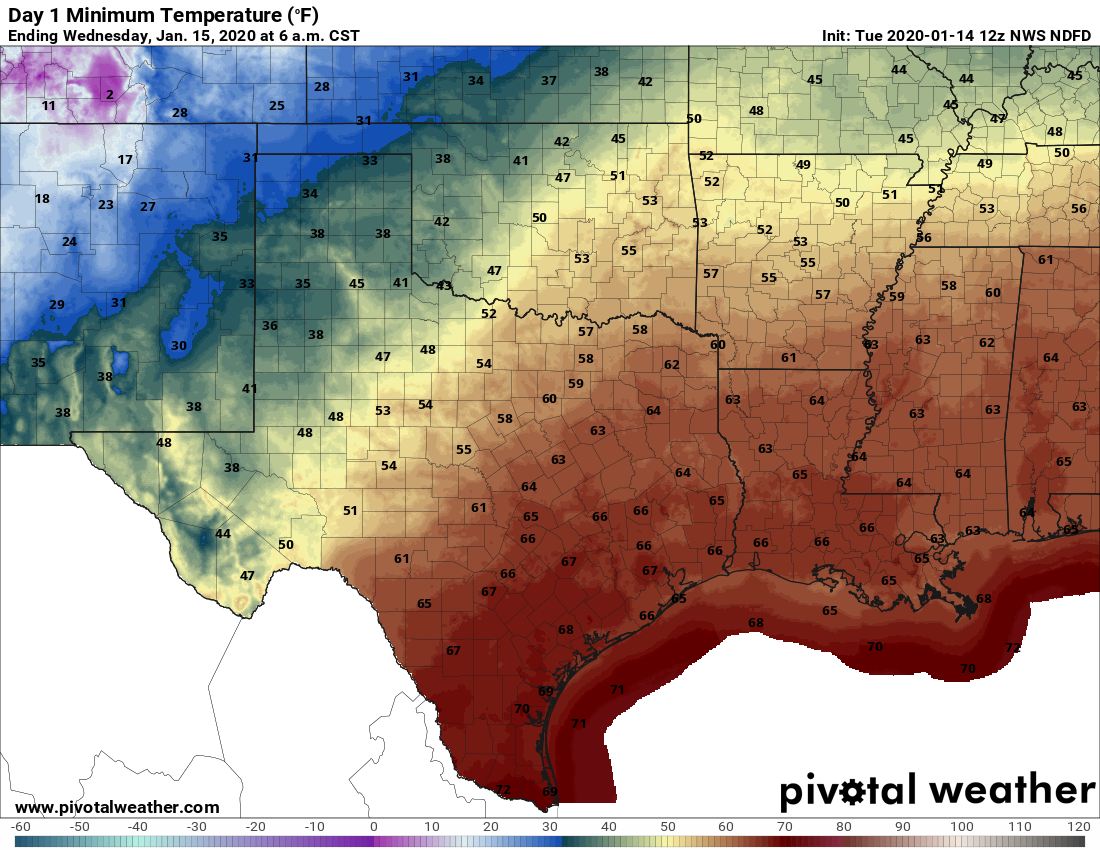
Temperatures are generally in the 40s or 50s this morning across Houston, but that’s probably the end of the cool weather until next weekend. A warm front will move onshore today, and will leave us with warm and muggy conditions for most of the rest of the week. Rainfall will never be too far away, but accumulations probably won’t be that significant, likely less than one inch.
Monday
Light showers along the coast should migrate inland along with the warm airmass moving in from the coast. After the rain moves through, we’ll be left with a mostly cloudy day, with high temperatures in the mid- to upper-60s. With a thick cloud deck Houston is unlikely to see much of a change in overnight temperatures. Lows tonight will probably only fall 3 to 5 degrees from high temperatures on Monday.
Tuesday
With the warm, moist air the region will likely see the development of sea fog along the coast as warm air moves over the cooler near-shore waters of the Gulf of Mexico and Galveston Bay. Highs Tuesday will reach the mid-70s. More rain showers will be possible on Tuesday, although at this point they likely will be more scattered than any activity on Monday. Lows Tuesday night are unlikely to fall much below the upper 60s.
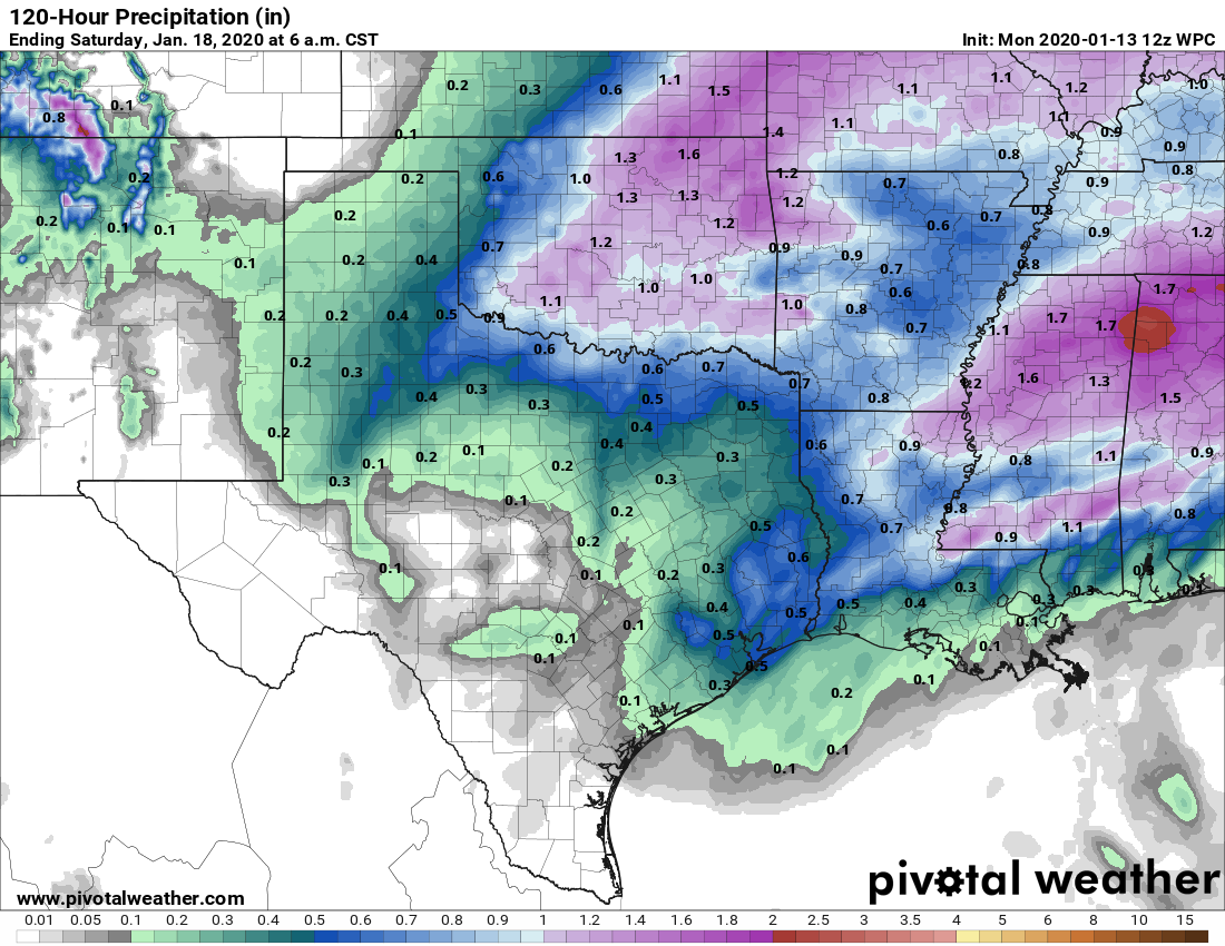
Overall rainfall accumulations this week should be modest. (Pivotal Weather)
Wednesday and Thursday
These will be two more gray days, with highs in the upper 70s and warm nights. Rain chances will likely take a step back to the 20 to 30 percent range. The bigger question is whether a cold front makes it all the way down through Texas and into Houston on Thursday. The answer at this point seems to be very likely not, although if you live in Montgomery County or points north there’s a slightly better chance of seeing some cooler and drier air on Thursday and Friday.
Good afternoon. Just wanted to jump in with an update on storms anticipated for tonight. We’re wary. We’re watching. But we’re not overly worried—and we don’t think you should be either.
This front and associated strong squall line have received a lot of media attention this week, and we’re not entirely sure why. It may be because there really has not been any significant weather to hit Houston for three months or so. But if anything, the model trend today is toward a slightly less severe threat for greater Houston. It’s definitely prudent to be weather-aware tonight. And I wouldn’t be out and about when the squall line hits. But we will face worse threats later this year so let’s temper expectations.
The primary threats tonight are damaging straight-line winds (we may see some gusts above 60mph), potentially a few tornadoes, and possibly some hail. Here’s the timing for the worst of the weather, which should last an hour or less for most locations.
11 pm CT
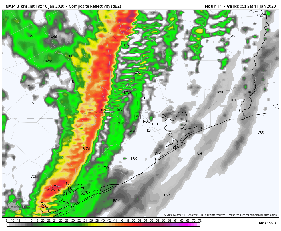
NAM model forecast for radar reflectivity at 11pm. (Weather Bell)
Midnight
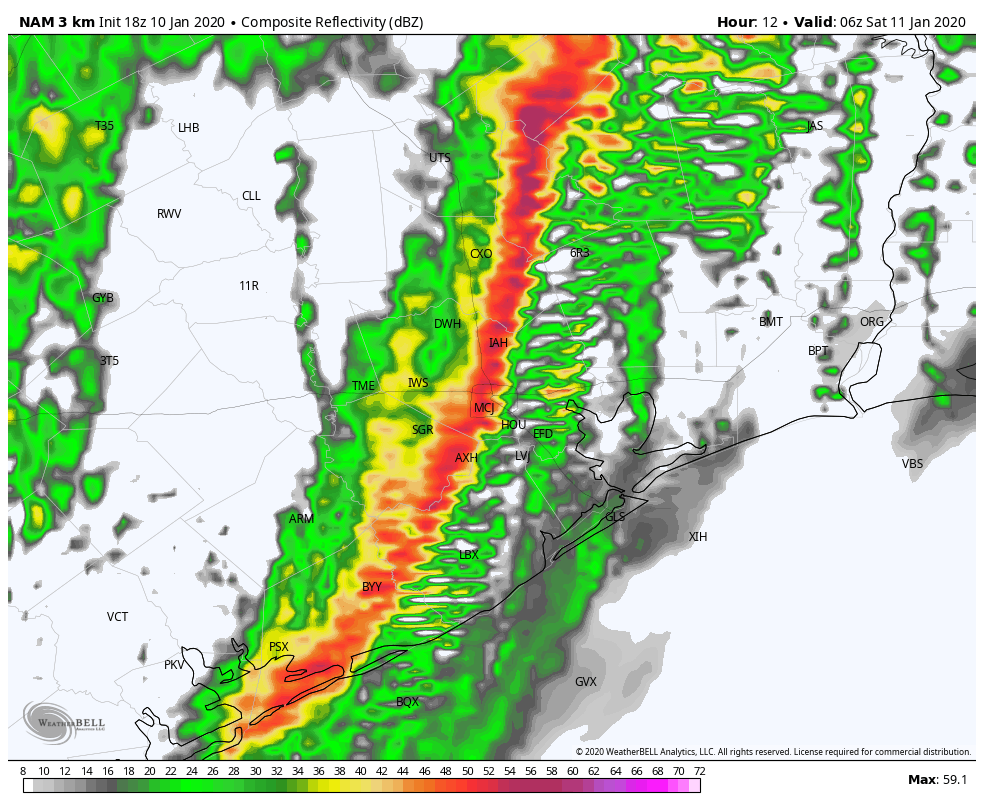
NAM model forecast for radar reflectivity at midnight. (Weather Bell)
1 am CT
NAM model forecast for radar reflectivity at 1am. (Weather Bell)
Stay safe! Please know that if conditions come in worse than expected we will be here to update as needed. Other than that, do enjoy the beautiful weather this weekend after the front passes.
As we’ve been discussing this week, the Houston area will see showers and thunderstorms later today or tonight and severe weather will be a possibility. I’m going to walk you through the day and hopefully provide answers to most of your questions.
Overview
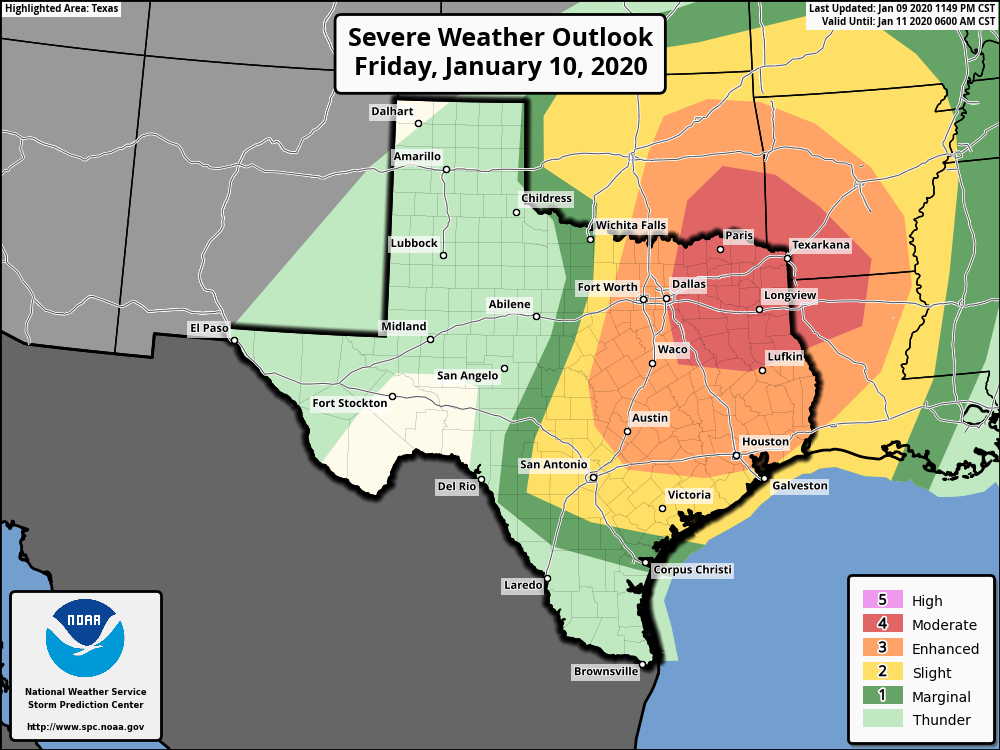
The Storm Prediction Center (SPC) is continuing to keep the majority of the Houston area in the enhanced risk for severe thunderstorms today.
The SPC has most of the Houston area in the enhanced risk (3/5) for severe weather for storms tonight. A slightly more significant risk exists well off to our north. (NOAA Storm Prediction Center)
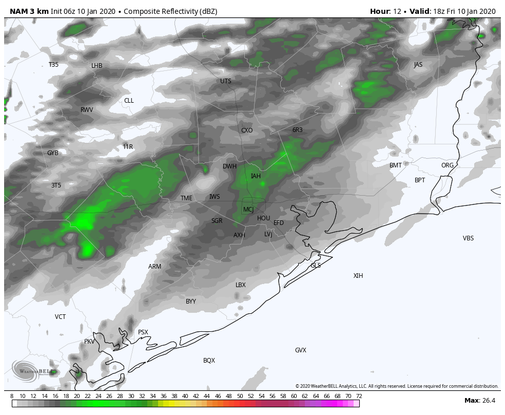
Based on what we’ve seen in modeling, for the Houston area, this threat will primarily occur much later today, after 5 PM and more likely closer to Midnight. So if you don’t see any rain or hear any thunder through this evening, do not be shocked. There may be isolated severe storms in the evening hours before a squall line of widespread strong to severe storms moves through just before midnight.
One model’s interpretation of what the forecast radar could look like between Noon today and 6 AM Saturday. (Weather Bell)
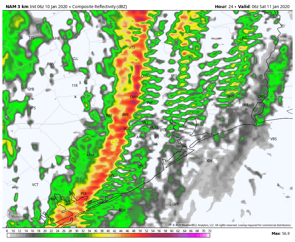
The severe weather threat quickly ends from west to east after midnight. The weekend looks fine.
This morning
Look for clouds and maybe a few passing showers. No severe weather will occur this morning. Temperatures, which actually rose a couple degrees overnight will continue slowly warming through the 70s. It will begin to turn breezy again, and winds could pick up to 15 to 25 mph or even stronger, especially along the coast and bays.
This afternoon (Noon to 4 PM)
We should see clouds, wind, and showers at times continue. Temperatures will warm into the mid- to upper-70s. We do not believe that the Houston area will see much in the way of thunderstorms this afternoon. Any strong to severe storms through afternoon will more likely occur way off to our north and west, well out of the metro area and region (think: Hill Country or perhaps up toward Tyler).
This evening (4 PM to 9 PM)
This is the part of the forecast in which we have the lowest confidence. Our best guess right now is that most of us will only see a couple passing showers in this timeframe. However, there is some chance that a couple rogue thunderstorms may begin to develop. Should this occur, any of those storms could quickly turn severe with hail, damaging winds, or even a tornado. To be clear: We believe this will very much be the exception, not the rule in the evening hours. Still, if you’re out this evening, ensure you have a way to receive weather warnings, just in case things get a little more chaotic than we are expecting right now.
Tonight (9 PM to 3 AM)
This will be the main timeframe that we see impacts from this event. Severe storms in Hill Country and the I-35 corridor should have congealed into an organized squall line by later this evening. Ahead of the line, we should see more numerous showers and a few thunderstorms begin to develop here. Any of those storms could become strong to severe, but it seems as though the primary concern will come from the squall line itself, which is going to quickly sweep across the region toward midnight.
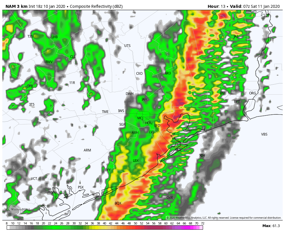
Snapshot of the NAM model’s forecast radar around midnight, which shows a well organized squall line. Typically, these types of systems have a higher risk of damaging winds than other modes of severe weather. (Weather Bell)
As of right now, we expect the line to hit College Station around 9 or 10 PM, Huntsville through Sealy by 10 or 11 PM, the majority of the Houston metro area between 10 PM and Midnight, Galveston through Lake Jackson between 11 PM and 1 AM, and Beaumont/Port Arthur between about 1 to 3 AM. All those times are approximate and give or take an hour or so.