After days and days of gray, sunnier skies are on the way

Good morning. For the last seven days, temperatures in Houston have averaged 10 to 15 degrees above normal for January, with mostly cloudy skies. Now, following a weak front on Monday, and a stronger one on Wednesday, Houston will return to somewhat more normal conditions for January, with cooler and clearer weather.
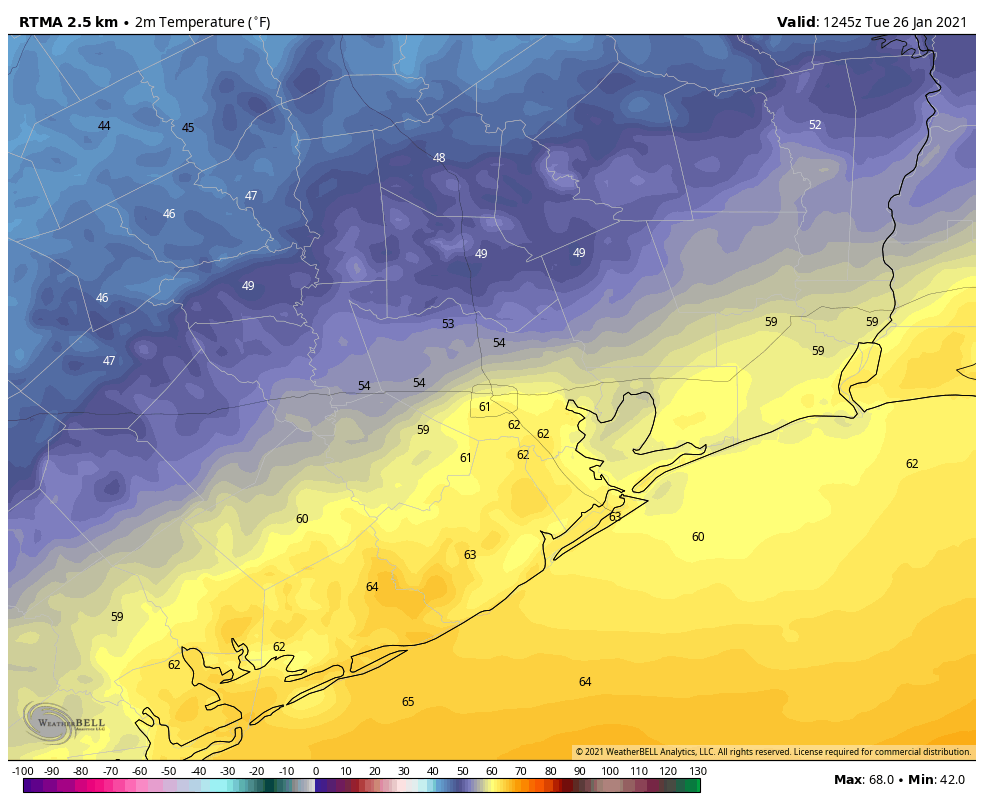
We’re seeing quite a variation in temperatures on Tuesday morning. (Weather Bell)

Tuesday

In the wake of Monday’s front winds are out of the northwest, but our air mass has modified only slowly, especially along the coast. As a result there is a wide variance in temperatures across Houston this morning, ranging from upper 40s for inland areas like Montgomery County, to the low 60s south of the city. This is because Monday’s front is lingering just offshore, and it may also allow for some clouds to form along the coast later today. Highs should get into the upper 60s or low 70s for most today, with winds shifting to come from the east. Overnight lows should drop into the 50s for most.

Wednesday

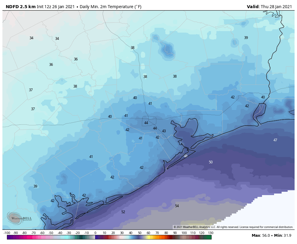
Another front will push into Houston on Wednesday morning, and this should bring somewhat more drier air. We can’t rule out some very light showers early Wednesday near the coast. However these will end with the front’s passage, and we should be left with a partly to mostly sunny day, with highs in the 60s. Wednesday night should be the coldest of the week, with temperatures dropping down to the low 40s in Houston.

Thursday morning should be the coldest of the week. (Weather Bell)

Thursday and Friday

High pressure will make for a pleasant end to the work week in Houston, with mostly sunny skies predominating. Highs on Thursday may not get much above 60 degrees after the cool start, and Thursday night should again see lows in the 40s. However, by Friday the onshore flow will push highs back into the upper 60s.

Saturday, Sunday, and beyond

The forecast for the weekend is coming into slightly better focus. We expect a warmish and probably cloudy day on Saturday, with high temperatures pushing up into the 70s. A chance of rain enters the forecast later in the day, when another front moves toward the region. Depending on the timing and movement of this front, we’re less confident about Sunday’s weather. Most likely, however, we’ll see partly to mostly sunny skies on Sunday after the front moves through. Monday and Tuesday of next week should see highs in the 60s, and lows in the 40s.

Houston’s stretch of really dreary January weather ends soon

It’s been a gloomy few days here in the Houston area, between overcast skies or fog or showers or drizzle. The bad news is that it continues somewhat today, but the good news is that the end is coming for tomorrow. It won’t be a brilliant, totally sunny week, but it will be a lot nicer than what we’ve had recently.

Today

We have the clouds this morning, but there is definitely less fog around than in some other recent days. Tough to find any location, even at the coast, with less than 5 miles of visibility this morning.

Visibility observations this morning are basically fog-free everywhere. (NOAA)

So that’s a good start. There are some showers around this morning already, none of which are particularly heavy, but expect sort of a dreary start to the day, with low clouds and light rain, heavy drizzle, mist, or a shower. A narrow band of slightly heavier showers may try to roll in with the cold front itself, late this morning northwest of Houston and around midday in Houston itself. The front should get to the coast by late afternoon.

You’ll know when the front passes by a wind shift and about a 5 to 10 degree temperature drop. We’ll reach the low-70s north and west of Houston before the front and the mid to upper-70s south and east of Houston. So the change behind today’s won’t be too dramatic initially.

Much cooler morning low temperatures in the upper-40s to low or mid-50s are expected overnight. (Weather Bell)

Where you’ll really notice the change will be tonight, as temperatures drop into the upper-40s to mid-50s for low temperatures by Tuesday morning.

Tuesday

Tomorrow won’t be perfectly sunny, but it will surely be a bit nicer than it has been. Look for a mix of sun and high clouds tomorrow, with high temperatures pushing back close to 70 degrees or a touch warmer.

Wednesday

A second cold front, this one a bit stronger, will push across the region on Wednesday morning. It will probably be a dry front, however. Look for a breezy day, with gusts of 15 to 20 mph out of the north. It will be sunny, but there will be a good deal of high cloud cover likely around at times to dim the sun. This should keep us in the mid to upper-60s for highs, after starting the day in the low to mid-50s.

Thursday & Friday

Expect more high clouds on Thursday, along with some sunshine. Friday may see the high clouds disappear, and it will likely start off sunny before some lower clouds roll in later in the day as onshore flow returns. Low temperatures for Thursday and Friday morning will likely average in the low 40s, though it will probably be in the upper-30s north and maybe upper-40s southeast of the city along the coast. For the daytime, expect cool upper-50s to low-60s on Thursday, followed up by mid-60s on Friday.

Weekend

It’s a bit early to say too much about this coming weekend, but it appears somewhat similar to this past weekend, with a good deal of low clouds, perhaps some patchy fog, and at least some shower chances, albeit low ones right now. We may see a cold front swing through the area by Sunday morning or afternoon, however, which could clear us out a bit and yield a nicer Sunday. Temperatures will be warm, with 70s for highs and 50s or 60s for lows. We should be back in the 40s on Monday morning behind the front, however.

Space City Weather and Reliant announce an extended partnership

Today we have an exciting announcement about the partnership between Space City Weather and Reliant. In the video below, Elizabeth Killinger, president of Reliant, and I discuss the origin of Space City Weather, talk about the importance of sponsorship, and what our new long-term agreement means for our readers and the future of the site.

The bottom line is this: Matt and I are committed to providing the best weather information we can, the way you want it—whether that’s a website, a redesigned e-newsletter or a smartphone app. This continued support from Reliant allows us to think about other ways we can serve Houston, and ensure that our forecasts will always be free, fast, and without hype.

Gray and gloomy weather remains through Sunday in Houston

On Wednesday in Houston, the fog never seemed to lift. On Thursday the fog eventually went away, but then a persistent drizzle never seemed to stop drizzling. So what gloom does Friday have to offer Houston? Today, we think, it will just be clouds. If you’re wondering when the sunshine will return, you’re going to have to hang on until Monday.

Friday

The front that stalled out over Houston on Thursday has finally moved into the Gulf of Mexico, but it’s not going very far, and there wasn’t all that much oomph left in it any way. So while winds have shifted to come from the north and northwest today across Houston, we won’t see too much drying out, and for all but western areas, skies will remain at least mostly cloudy. Highs should reach about 70 degrees for most areas, with the city dropping to 60 degrees tonight, with temperatures in the 50s for outlying areas. At least it probably won’t rain today—not something we can say for the entire weekend.

Saturday

Some fog will be possible on Saturday morning, but it won’t be like what we saw earlier this week. Skies will still be mostly cloudy, and as winds shift to come from the east moisture levels in the atmosphere will increase. I’m confident the morning will remain rain-free across Houston, but some light showers will be possible later in the day and overnight. Highs Saturday will likely climb into the upper 60s, with lows dropping only perhaps 5 to 10 degrees with little diurnal cooling.

NOAA rain accumulation forecast for now through Wednesday. (Weather Bell)

Sunday

We can probably expect a healthy amount of fog on Sunday morning as warmer air moves over cooler bodies of water. Rain chances will be healthy on Sunday, and the day may be a lot like what we just experienced on Thursday, with widespread light rain not leading to much in the way of accumulations. Highs will likely be in the mid-70s, with a very warm night in the mid-60s. So yeah, it’s a pretty bleh weekend.

Monday

Finally, on Monday, a stronger front will work its way into the Houston area. Our best guess on timing, at this point, is mid- to late morning. A broken line of showers, and perhaps a few thunderstorms, may accompany the front. But our atmosphere will dry out quickly with its passage, and skies should turn mostly sunny in its wake. Lows Monday night should fall to around 50 degrees.

Next week will first turn cool, and then cooler still. (Weather Bell)

The rest of next week

Next week should see a succession of at least partly sunny days. Another front later in the week should knock lows down into the 40s for most of the area. The models aren’t indicating anything too crazy in terms of precipitation, so compared to the week we’re now experiencing, next week looks pretty great.