Houston goes from 80s and sun to 50s and gray, just like that

It was officially 80 degrees yesterday in Houston. We fell one degree shy of the record high at both Bush & Hobby on Thursday. Today will not be a repeat of that, not by a longshot.

Today

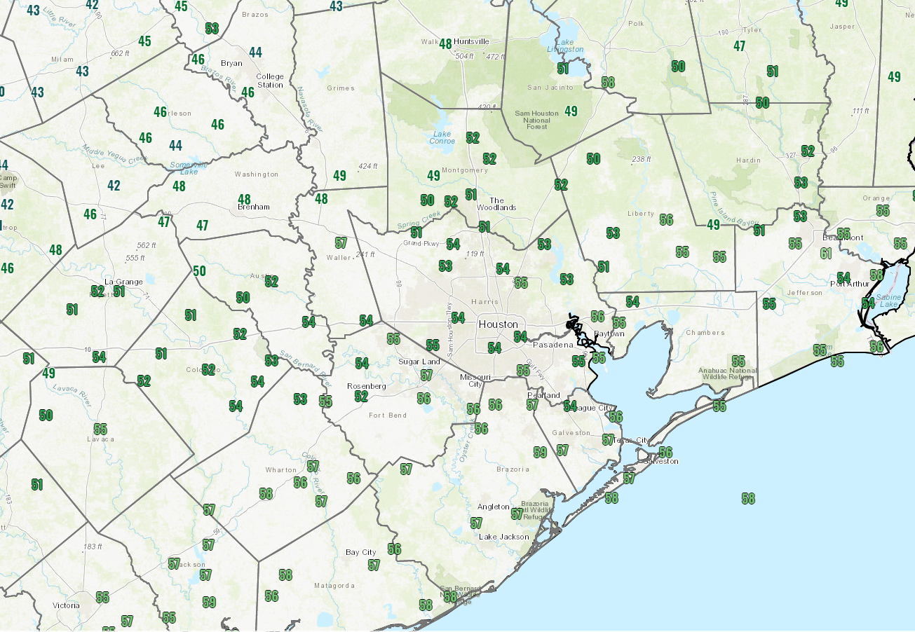
It’s starting off in the 50s and upper-40s this morning, and honestly, temperatures may not go very far from these values today.

It’s a lot cooler out there this morning than it was yesterday! (NOAA)

Today is going to be one of those chilly, raw, damp winter days here in Houston with off and on showers or light rain, a lot of clouds, and a bit of a breeze.

We could use a little rain, so hopefully we can snag a couple tenths of an inch here or there through the day. Look for showers to diminish tonight, with partial clearing and lows generally in the 40s, though a few spots up north could drop into the upper-30s.

Weekend

Tomorrow will start similarly kind of gray. We should hopefully see breaks in the clouds during the afternoon. And we’ll see complete clearing once another cold front sweeps in Saturday afternoon or evening. Ahead of that front, look for highs in the 60s tomorrow. A chilly night is on tap for Saturday night with lows dropping into the 30s and 40s. Sunday looks spectacular. Expect a lot of sunshine, high temperatures in the 60s, and light to moderate winds.

Monday through Wednesday

Onshore flow will kick back in late Sunday, so Monday morning will not start off nearly as chilly as Sunday morning. Look for morning temps in the 50s, with a few upper-40s scattered about. Clouds will be with us on Monday as well. Despite the clouds, temperatures will surge to near 70 degrees.

The forecast begins to fall off the rails Tuesday with some changes since yesterday. A cold front is projected to get close to Houston by Tuesday afternoon. Models differ dramatically on the timing and orientation of the front through Wednesday and even Thursday, with the GFS model stalling it in our neighborhood and the European model suggesting it stalls well offshore. A map of forecast dewpoints for Wednesday shows this well.

We have a real forecasting headache next week, and it begins on Tuesday or Wednesday, as the European model (forecast dewpoint shown on left) clears a front offshore, while the GFS (forecast dewpoint on right) hangs it back to our north. Who is right? Next question. (Weather Bell)

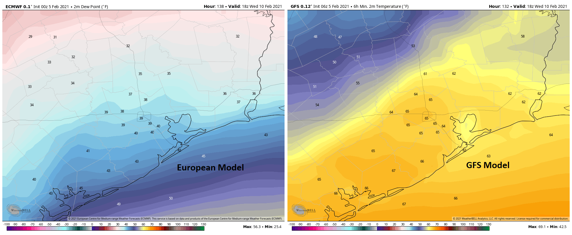
This obviously has implications on everything from temperatures to cloud cover to fog potential to shower chances for next Tuesday and Wednesday. If the front clears, expect highs in the 60s or 50s Tuesday and Wednesday, with lows in the 40s Wednesday. If the front does not clear, expect highs in the 70s, perhaps well into the 70s and lows in the 60s, along with fog at the coast or even into the city. Normally, I’d say the cooler outcome is probably correct, but the GFS model tends to have a bias where it’s too fast with fronts pushing offshore so seeing it be opposite of that gives me a little pause. At the same time, models tend to struggle with the type of cold air masses we are expecting in our region by midweek next week, bringing them in too slowly. So the forecaster’s conundrum is in place next week, and either outcome seems perfectly reasonable. We’ll have a good bit more clarity on Monday.

Late next week

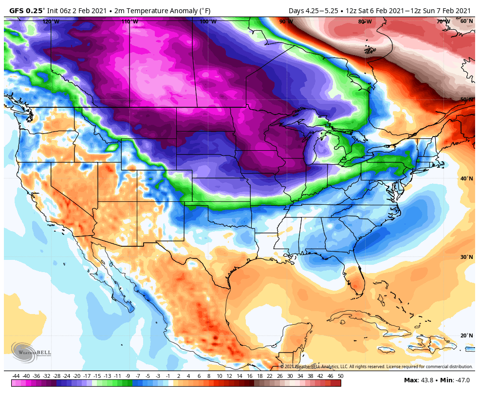
The forecast really goes off the rails later next week. All we can tell you at this point is to expect unsettled weather and potentially the coldest weather of winter. Models have taken a bit of a dramatic step colder since yesterday for next weekend, with most reliable model guidance indicating a freeze, if not a hard freeze will be possible focused on Saturday or Sunday. Whether or not that actually happens will depend on how the potential for rain or wintry precipitation exactly plays out next Friday and Saturday. I think Eric’s 20 percent call on snow risk is still reasonable, though I think I might unfortunately call it “snow OR ice” right now. I wish we could be less vague, but this period has been in flux for several days. Either way, we believe you will want to continue to monitor the forecast for the end of next week and weekend in the coming days and be ready to implement your cold weather preparations later next week. It’s been a minute since we last saw 20s in Houston in February, last occurring back in 2014. A reminder that, although rare in recent years, it can absolutely still get quite cold this late in our winter. Much more to come on this.

Springtime for a day in Houston, before winter makes its return

It’s a rather warm morning across the region for early February, with lows in the 60s. We’re on the way toward a very warm afternoon, with highs near 80 degrees. But as we’ve been talking about, do not take this as a sign that winter is over. We’re still anticipating a pretty robust cooldown next week that could very well bring a freeze to parts of the Houston area, if not all of it.

Thursday

A warm, southwesterly flow will allow temperatures to warm into the upper 70s to 80 degrees this afternoon. Areas that see a bit of sunshine will probably reach 80, and chances of this are highest just west of Houston. This flirtation with spring will will end this evening, as a front reaches areas northwest of Houston around sunset, drops into the city of Houston between 8 and 10pm, and reaches the coast around midnight. A very light band of rain may accompany the front.

It will be a warm day for Houston on Thursday. (Weather Bell)

Friday

Lows on Friday will drop down to around 50 degrees, in the wake of the front. Winds will be out of the north, and even with partially clearing skies, highs may only rise to around 60 degrees for most. Lows will probably drop into the upper 40s overnight, as winds shift to come from the east.

Saturday

Thanks to this warmer onshore flow, highs on Saturday will probably climb to around 70 degrees with partly sunny skies. However, by the afternoon, a second front should arrive and this will again cool Houston down to around 50 degrees overnight.

Sunday

The second half of the weekend looks splendid, with highs near 70 degrees, lots of sunshine and dry air. Seriously, do something outside.

A lot of cold air is coming into the Lower 48 next week. It remains to be seen just how much will make it to Houston. (Weather Bell)

Next week

Monday and Tuesday both look reasonably warm, with highs in the upper 60s or lows 70s and a mixture of sunshine and clouds.

The pattern changes on Wednesday with the arrival of a cold front, which should bring several days of significantly colder air into the region. With mostly cloudy skies for a few days, the second half may see highs in the 50s (or even 40s?) and lows in the 30s (or maybe even 20s?). This raises the possibility of wintry precipitation by next weekend, or so. I think there’s a solid 20 percent chance or snow, but given the delicacy of such a forecast—which is to say a lot of ingredients must line up just right for snow to fall along the upper Texas coast—we’re still a long way from being able to forecast what will happen with confidence. So, stay tuned!


Houston to briefly approach record warmth, then cool down again

We now interrupt our previously scheduled winter to bring you a brief taste of spring for the next couple of days. But fret not, we expect moderately cooler weather to return this weekend, and possibly a full-on Arctic blast later next week. At this point we’re not even ruling out snow—although the chances of seeing this in Houston remain about 20 percent for now.

Wednesday

Conditions are starting out chilly enough this morning, with much of the area dropping into the upper 40s. However with light winds out of the east, and shifting to the southeast later this morning, Houston will warm up to around 70 degrees this afternoon. Skies will be partly to mostly sunny. Lows tonight will only drop to around 60 degrees in the city city, beneath mostly cloudy skies.

Thursday

Houston will really warm up on Thursday, with a strong southwesterly flow bringing warm air across the region. Highs should generally reach the upper 70s to about 80 degrees in some locations (the record high temperature at both Bush and Hobby airports is 81 degrees). Temperatures will depend, somewhat, on the extent of sunshine that breaks through the afternoon clouds. We’re now more confident in the timing of the region’s next front, which should reach northwest areas around sunset on Thursday, push into central Houston between 8 and 10 pm, and reach the coast roughly around midnight. Rain chances are slight, and any rain that falls should be brief and light. Lows Thursday night should drop to around 50 degrees.

NAM model forecast for position of cold front at 9 pm CT Thursday. (Weather Bell)

Friday

Expect a breezy start to Friday in the wake of the front, with highs climbing into the low 60s or so under partly sunny skies. Lows Friday night will drop into the 40s for inland areas, but remain in the 50s closer to the coast.

Saturday and Sunday

The cold front will be short-lived, as it moves back onshore on Saturday. This should make for a bit warmer day, with highs in the upper 60s to 70 degrees, to go along with partly sunny skies. Another front drops into the region Saturday night, and this should ensure sunny skies on Sunday, with highs perhaps in the mid-60s. Lows should drop in the upper 40s by Sunday night.

Look, we’re not saying it’s going to snow in Houston. But there is a non-zero chance next week with several ensemble members hinting such. (Weather Bell)

Next week

We expect Monday and Tuesday to be pleasant days, with highs in the mid-60s to around 70 degrees or so. By later Tuesday or Wednesday, however, we see a front bringing significantly colder air into the region. While it’s still too early to say much about the details, this front will bring a decent chance of a freeze to the region by the second half of next week. We also can’t rule out some wintry precipitation, but again it’s just too far away to have much confidence right now.


Houston will warm up, but don’t plant your gardens just yet

Good morning, Houston! It’s another chilly one across the metro area with lows ranging from the upper 30s in outlying areas to around 50 degrees right along the coast. We’re now going to follow a warming trend through Thursday. Enjoy the 70s, because it looks increasingly likely that winter will make a resurgence into the United States—including Texas—later next week. Details are to be determined, but don’t plant your gardens yet!

Tuesday

Winds will shift to come from the southeast later today, but they’ll remain light. This should allow for a few clouds to form, but we still anticipate partly to mostly sunny skies as high temperatures rise into the mid-60s or so for most areas. Lows tonight should drop to around 50 degrees in the city of Houston, with cooler conditions inland, and warmer weather right along the coast.

Wednesday

Conditions will be a bit warmer on Wednesday, with highs near 70 degrees, and perhaps a few more clouds. More clouds still will build overnight and lows may struggle to fall below 60 degrees on Wednesday night in the city and along the coast.

High temperatures on Thursday will be warm for February. (Weather Bell)

Thursday

This should be the warmest day of the week, and the warmest day for quite a while as southwesterly winds really start to blow across the area. We may see gusts up to 25 mph. Depending on the amount of sunshine at your location, high temperatures may briefly reach 80 degrees, although I think most areas will stay in the 70s. Regardless, it will feel fairly warm for a day in February.

Friday

A cold front will sweep through Houston on Thursday night or Friday morning—best guess right now is that it reaches the upper Texas coast around sunrise on Friday morning, although there is some wiggle room in that. There are some slight rain chances with the front, but it should be dry for most. We should see a cloudy day in its wake, with highs in the low 60s perhaps. Winds will be notable, out of the north. Lows Friday night should drop into the upper 40s for most areas.

Saturday and Sunday

Saturday will be pleasant, with mostly sunny skies and highs in the upper 60s, or thereabouts. A second cold front will arrive Saturday night and highs on Sunday may not climb out of the 50s. Skies should be sunny at least. Lows will reach down into the 40s.

Next week

While the forecast for next week is not yet written into stone, a serious mass of cold air is expected to build over Canada this weekend—note the forecast for temperatures more than 30 degrees below normal for Saturday and Sunday up north.

Colder-than-normal air pools over North America this weekend. (Weather Bell)

Next week some of this Arctic air should dive down into the United States, and we think at least some will probably reach Texas by the middle of February. As we said, the details of this are still to be determined, but we don’t think winter is yet done with Houston.