Coming soon to a smartphone near you: The Space City Weather app

Last September, in the days following Hurricane Laura, Arnold Ventures reached out to Space City Weather and asked if they could help broaden our reach in the Houston community. Now, thanks to their $25,000 gift, I’m excited to say we’ve been able to move into development of a Space City Weather app. I’ve asked my former colleague at the Houston Chronicle, tech guru Dwight Silverman, to lead this effort. He explains more in today’s post.

Almost immediately after Space City Weather’s launch more than five years ago, readers began asking: When are you going to have an app?

Finally, the answer to that question is: Soon.
Last week, Eric signed an agreement with Hussain Abbasi to develop an app for both iOS and Android devices. Our goal is to have it ready in time for this year’s hurricane season—though since tropical weather happens well before the official June 1 start, we’d like to have it in the app stores before then. And thanks to this gift, the site’s ongoing sponsorship with Reliant, and our generous readers, it will be free for everyone, with no in-app purchases.

I am honored that Eric asked me to shepherd the development, working closely with Hussain and SCW’s technical wizard, Lee Hutchinson. I provided feedback during the development of apps at the Houston Chronicle during my time there, so I’m familiar with the process. Being able to serve this site’s community is exciting, because I feel the same way about Space City Weather as a lot of you: It’s an important asset for the city and the region.

The app we’re building will feature Eric and Matt’s blog posts, local weather info, timely alerts, and many of the things you’d expect—with a distinctly local twist. We are not trying to duplicate the many other meteorological apps out there, because if you’re seriously interested in weather, you probably already have one or more on your phone.

Let’s put it this way: For residents of the greater Houston area, it’ll be a must-have. If you live in, say, Minneapolis . . . not so much!

We’ll share more as the development process evolves. Watch this space. And the skies, of course.

Yes, the Arctic Blast is real, and it could be a real mess

Our confidence in the forecast for an upcoming outbreak of cold weather, in terms of timing and intensity, is increasing although many questions remain. We think the worst conditions should come next Monday and Tuesday, when there’s a healthy chance of wintry precipitation and a widespread, hard freeze.

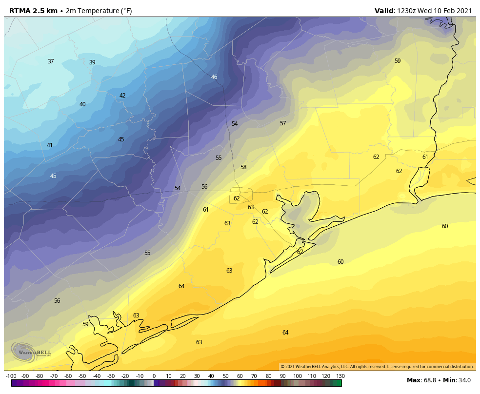
Sunrise temperatures in Houston on Wednesday depend on which side of the front you sit. (Weather Bell)

Wednesday

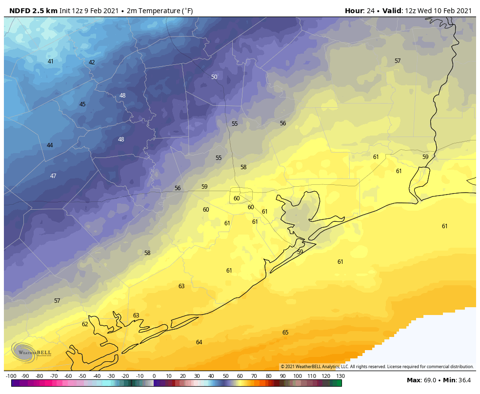
At present, a thin layer of colder air at the surface has pushed into northern parts of the metro area. As a result, temperatures this morning are in the low 50s in parts of Montgomery County, while much of Houston and coastal areas are about 10 degrees warmer. Because of this more moist airmass near the coast, fairly dense sea fog has developed and will persist for a couple of hours after sunrise. After the fog lifts, skies will be mostly cloudy for the remainder of the day, with about a 30 to 40 percent chance of scattered showers. Highs will depend upon which side of the cold front you lie, but generally, temperatures should be in the 60s today, and 50s tonight in Houston. Scattered light rain chances will persist tonight.

Thursday and Friday

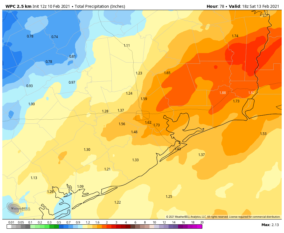
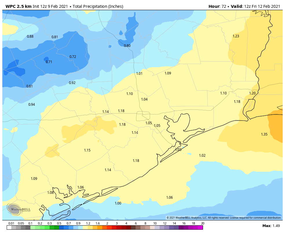
The front should more completely push through the Houston area on Thursday morning, by or before sunrise, and move off the coast. This is the beginning of a big change in Houston weather, and it will start with healthy rain chances for much of Thursday, Thursday night, and Friday morning. Most models are trending wetter, and at this point it would not surprise me to see 1 to 2 inches during the period, with higher isolated totals. Highs Thursday will be in the 50s, lows Thursday night generally in the 40s, and highs in the upper 40s on Friday with mostly cloudy skies after the rains end.

NOAA rainfall forecast for now through Friday. (Weather Bell)

Saturday

Well, it’s not much, but Saturday looks to be the “pick” of the weekend, with partly sunny skies and high temperatures that may reach about 50 degrees. A reinforcing shot of colder air should arrive on Saturday, setting the stage for near freezing temperatures in Houston during the overnight hours.

Sunday, Monday, and Tuesday

This is the period of the forecast where we expect the coldest weather to occur, and a potential for sleet, freezing rain, or possibly snow. There are, frankly, a lot of atmospheric ingredients at play including the amount of cold air moving into the region, and the evolution of an upper level low pressure system that should bring precipitation into the forecast.

For now, Sunday looks partly to mostly sunny and cold, with highs perhaps in the low 40s or thereabouts. Sunday night will likely see a widespread freeze across Houston, with increasing precipitation chances overnight.

Monday should see the best chance of precipitation. But what form will it take? For areas north of Houston and west of Katy, high temperatures on Monday may struggle to get out of the low 30s. So there’s going to be a rather healthy chance of sleet, freezing rain, or possibly snow. I expect this may well be the case in Houston as well, we just don’t have extremely high confidence in temperatures at this point. Bottom line: Monday has the potential to be a real mess on the roads, and school closures are possible if your district isn’t already shut due to President’s Day. Obviously we’ll be tracking all of this for you in the coming days as best we can.

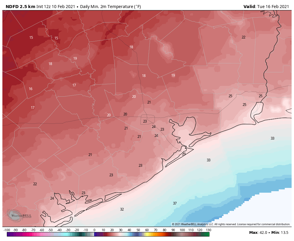
National Weather Service forecast for lows Tuesday morning. (Weather Bell)

Finally, Tuesday looks to see the coldest weather. With the potential for some clearing skies on Monday night and early Tuesday, we could see temperatures plunge on Tuesday morning. I’m not ruling out temperatures in the teens for outlying areas, and potentially even in Houston itself. More likely lows will be in the 20s, and that will be cold enough to worry about exposed pipes. My best guess for Houston right now is a low between 20 and 25 degrees, with colder conditions inland, and still a freeze right along the coast.

Temperatures should begin to recover by Wednesday.

Yep, it’s gonna get pretty durn cold in Houston

Good morning. The main news remains the potential for very cold weather in Houston during the coming seven to 10 days. While we still have questions about the details it is now time to begin considering preparations.

Also, it’s worth noting that very cold weather in February is far from unprecedented. Back in 1899, the city of Houston recorded consecutive days with low temperatures of 6 degrees on February 12 and 13. That means only six degrees of separation from a low of zero degrees.

Tuesday

As expected, moderate to dense fog has developed across the region this morning, with muggy conditions in the 60s. This fog may not dissipate until 9am or so for some areas. A front will sag into Houston today, and stall around 30 to 50 miles from the coast. Effectively, this means if if you live inland of Interstate 69, highs today may generally be in the 50s, but if you live south and closer to the coast, highs will be in the low 70s. Some scattered showers will be possible area-wide today. Overnight lows will be similarly dependent upon the extent of the front.

Low temperatures on Tuesday night will depend on which side of the front you live. (Weather Bell)

Wednesday

Conditions should be similar on Wednesday, with the front stalled out across Houston. Depending on where it’s hung up, you may see highs in 50s with drier air, versus highs in the 60s with more humidity.  Rain chances will be a bit higher, with perhaps a 40 percent chance of light to moderate showers.

Thursday

One more day of divided temperatures, with warmer conditions along the coast, and cooler weather further inland. Rain chances will be that much higher as a stronger, Arctic front approaches, and pushes into Houston later on Thursday. Most areas should see between 0.5 to 1.5 inches of rainfall through Friday morning.

NOAA rain accumulation forecast for now through Thursday. (Weather Bell)

Friday

We’ll see a much colder day on Friday, with highs perhaps in the low 50s and partly sunny skies. Lows Friday night will drop to around 40 degrees.

Saturday and Sunday

A reinforcing shot of Arctic air looks set to move into the coastal region on Saturday, and this is what will likely set the stage for much colder weather early next week. Highs on Saturday may remain in the 40s, with lows dropping into the 30s for Houston, and 20s for inland areas well inland on Saturday night. Sunday may struggle to get out of the 30s, with lows Sunday night again likely below freezing for much of the metro area. Happy Valentine’s Day—this will not be the best of years for planning some sort of outdoor surprise!

Early next week

Quite frankly, we’re still struggling with how cold conditions will get during the Sunday through Tuesday period of next week as the models are really all over the place. Some ensemble members of the GFS suggest temperatures could reach their nadir on Tuesday morning, in the teens even in the city of Houston. This probably is too cold, but a widespread and potentially hard freeze does seem likely. It is time now to consider preparations for plants and pets, and if temperatures drop below about 25 degrees, external pipes. Please note the details of this medium-range forecast remain uncertain, and therefore will change. And when it comes to low temperatures like these, small changes matter.


First comes the warmth, before Houston plunges back into the depths of winter

After Sunday’s brilliant weather our conditions this week will turn a little bit more cloudy, and increasingly warmer until a strong cold front Thursday ushers winter back into the region. We’re still anticipating much colder weather for next weekend, although how cold—and how much of the region sees a freeze—is yet to be determined. We’ll discuss below.

Monday

With winds shifting from the east to come from the southeast this morning, today will see increasing cloud cover across Houston. High temperatures will likely reach about 70 degrees. With the southerly flow, temperatures on Monday night likely will not drop below 60 degrees in the city of Houston, with slightly cooler conditions for inland areas.

Tuesday

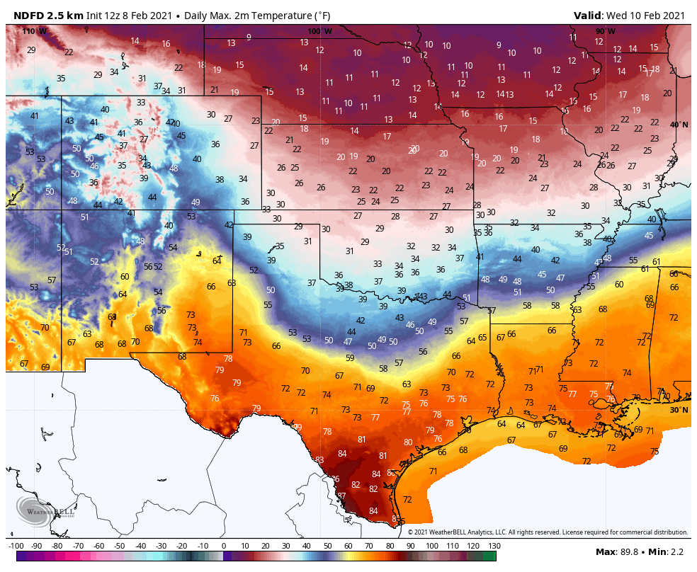
With the warmer overnight air, we may see at least some patchy fog develop on Tuesday morning. Skies should again be partly to mostly cloudy, but even so high temperatures will likely get into the mid-70s. It will be another warm nighttime for February, with lows in the low 60s. Some very slight showers are possible, although unlikely.

Look for a striking temperature gradient on Wednesday, with a front moving into Texas. (Weather Bell)

Wednesday and Thursday

The middle of the week will see continued warm weather, with clouds. As atmospheric moisture levels increase, we should start to see scattered, light showers on Wednesday and Wednesday night. Rain chances increase Thursday as a cold front approaches and passes through the area—although whether this happens around noon on Thursday or during the evening hours, it’s difficult to say. Most areas should see 0.5 to 1.5 inches of rainfall with this front, which the region could use.

Friday

The end of the work week should see much colder weather, with highs likely in the 40s to 50s, lots clouds, and colder norther winds. Lows Friday night will likely drop into the 30s, likely. Brrrr.

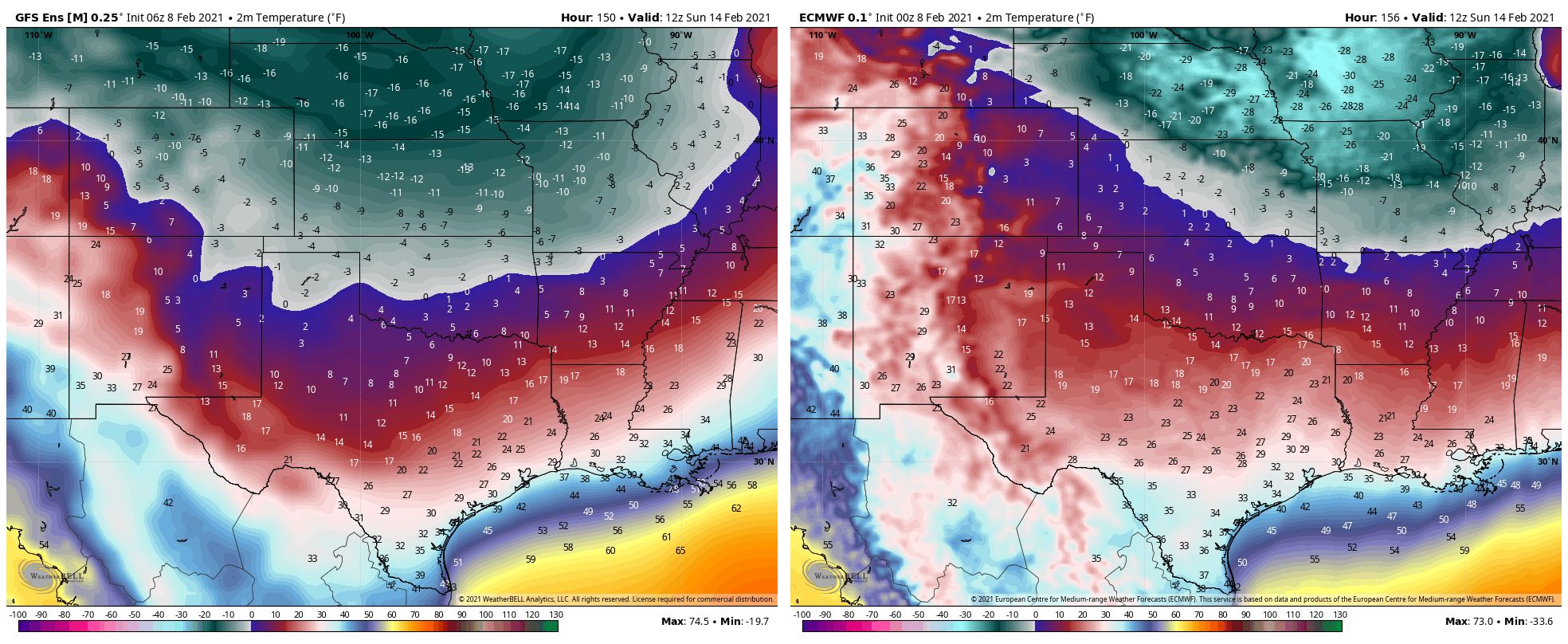
The GFS model shows colder air further south this weekend, while the European model bottles it up, and shift its more eastward. (Weather Bell)

Saturday and Sunday

The biggest question for our forthcoming weekend concerns Arctic air that will be diving into the central United States. Specifically, how much of this colder air reaches all the way down to the Texas coast, and how much is shunted off to the east? Some models, like the GFS, show bonkers cold temperatures as low as the teens. That’s highly unlikely. However, by Sunday morning I do think it’s reasonably to expect lows to reach the neighborhood of 25 to 35 degrees for much of the area, except for the immediate coast. Some additional precipitation is possible over the weekend and into early next week, and we’ll have to monitor its potential to come as snow, ice, sleet, or something in between. So, stay tuned.