You have questions about the Gulf tropical system, and we have (a few) answers

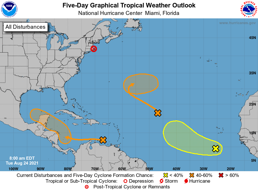
We’re continuing to track development of a tropical system in Caribbean Sea that should move into the Gulf of Mexico this weekend. And while we don’t have a lot of additional clarity, we have received a lot of questions today. So although we can’t answer them all, we’re going to do our best.

As of Wednesday afternoon, here’s what we know, and what we don’t, about Invest 99L.

Where is Invest 99L going?

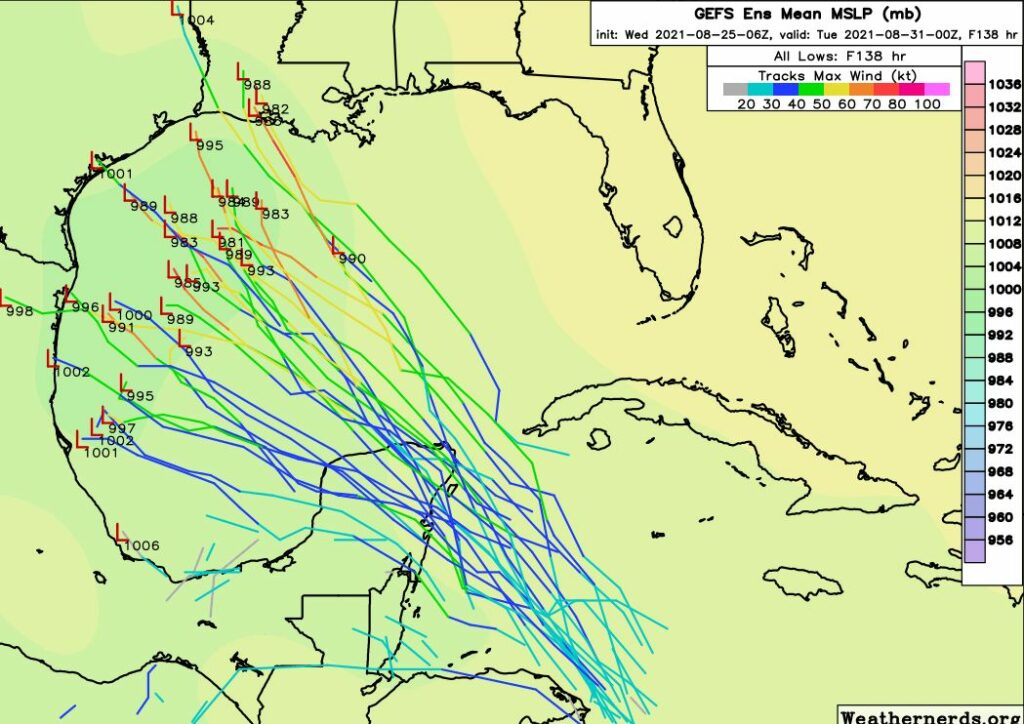
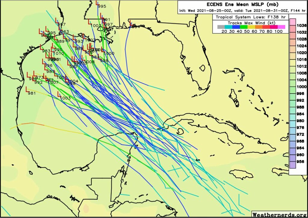
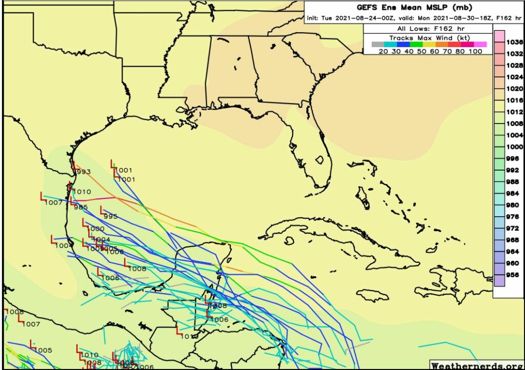
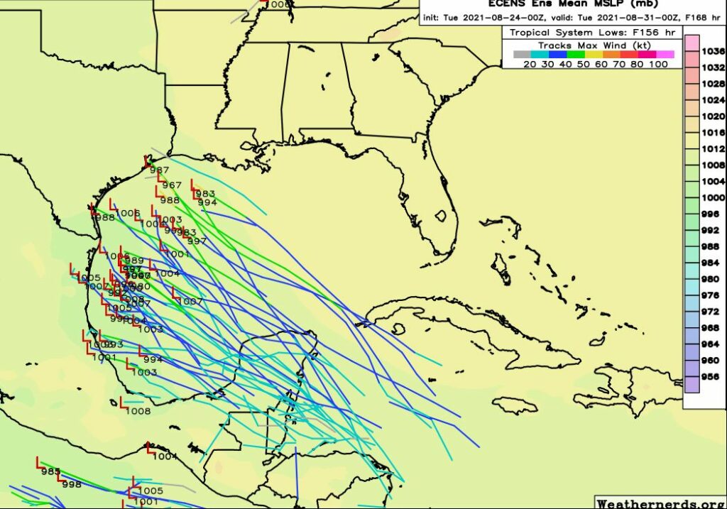
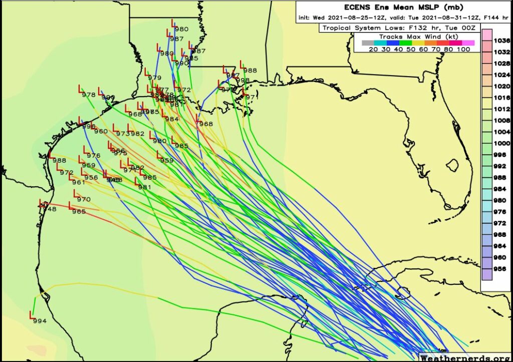
Not much has changed since this morning. We are reasonably confident that the storm will ultimately track toward Texas or Louisiana. Mexico seems less likely because it appears the storm’s center is further north than where forecast models initialized it earlier today. But beyond this there is a wide variance in solutions, and until the system gets more tightly defined, the models are going to struggle with solutions.

European model ensemble forecast released on Wednesday afternoon. (Weathernerds.org)

When will we know more?

We should know more within 24 hours, and probably have a pretty good sense of things by Friday.

When would we start to see effects the system tracks toward the upper Texas coast?

The earliest would probably be Sunday afternoon or evening, and more likely on Monday.

How strong will Invest 99L get

No idea. Anything from a tropical storm to a major hurricane is possible. However, we’re definitely concerned about intensification. The Gulf of Mexico is near its peak heating for the year, and the atmosphere does not appear particularly hostile to tropical systems this weekend. So yeah, a powerful hurricane is a definite possibility.

Be straight with us, is this going to be another Harvey?

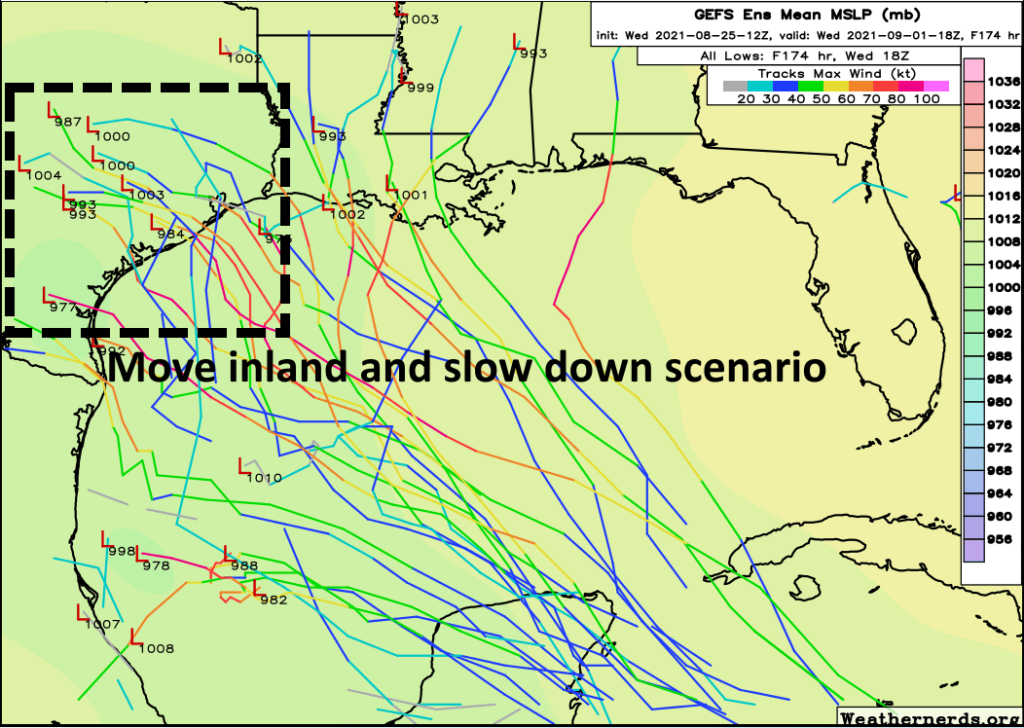
Hurricane Harvey made landfall four years ago today, and then its steering currents collapsed. This lack of movement caused heavy rains to remain in place over the upper Texas coast, including Houston, for days. Right now we don’t expect a repeat of this, but there are some scenarios in which this system goes into the central Texas coast and then does slow down somewhat. In this case, Texas would see heavy rainfall, but probably not anything approaching Harvey’s biblical levels. It’s worth emphasizing that is just one of many possibilities we are watching at this point.

GFS ensemble forecast for Wednesday afternoon. (Weaternerds.org)

Stop it, y’all are scaring me.

Yeah, we get it. We don’t like hurricanes either. Matt and I own homes here. Hurricanes can be intimidating things. Please understand there are still a wide range of outcomes for this tropical system, and a majority of them right now involve minor impacts to the greater Houston region.

But here’s the deal. We probably aren’t going to have a real good handle on this system until later Thursday or Friday, and by that time we could only be two or three days from seeing significant impacts. So now is the time to review your hurricane plans. For example, under what circumstances would you evacuate? Where would you go? Do you have a plan to take care of pets? Do you have a hurricane kit if you’re staying home? When the time comes to make a decision, we want you to be ready to make it.

We’ll have a full update Thursday morning.

Tropical system bound for Gulf, may land in Texas or Louisiana

Good morning. This post will address our increasing rain chances toward the end of this week, and then discuss the tropical storm likely to form in the Gulf of Mexico this weekend. The short summary is: The system will bring a lot of moisture with it, and while it may directly impact Texas, it may also make landfall east of the state. Please bear with us, we should have better confidence in a day or two.

Wednesday

The high pressure system that has been responsible for several hot and sunny days will start to retreat slowly to the northeast, and this will allow for more clouds to form today. This will lead to a few scattered showers this afternoon and evening, with perhaps a 30 percent chance of rain at your location. High temperatures should still get into the mid- to upper-90s so this will be something of a transition day to a wetter pattern.

Thursday and Friday

These days will see a mix of sunshine and clouds as upper-level disturbances rotate around the southern edge of the high pressure system. About two-in-three areas will rain each day, and for the most part two-day accumulations should be on the order of 0.5 to 1.0 inch of rain. This should help to moderate temperatures some, and we should look for highs in the low 90s both days.

NOAA rain accumulation forecast for now through Saturday. (Weather Bell)

Saturday and Sunday

If you’ve got outdoor plans for the weekend you’re going to be rolling the dice. Saturday looks like it should have slightly less rain coverage than Sunday, but both days are probably above 50 percent in terms of your odds of seeing at least a passing shower. Sunday’s weather will be determined, in part, by the evolution of a tropical system now in the Caribbean Sea that should move into the Gulf of Mexico this weekend. And because there is so much uncertainty about that, it’s really hard to have much confidence in the weather forecast for Sunday and beyond.

Tropics

The National Hurricane Center now gives the Caribbean system, known as Invest 99L because it has been designated an “area of investigation,” an 80 percent chance of developing into at least a tropical depression or storm within five days. We think it’s highly likely that a tropical storm will form in the southern Gulf of Mexico by Sunday. So what happens after that?

Yesterday the bulk of the model guidance suggested 99L would move toward the Mexico mainland or Texas, but we cautioned there was a high amount of uncertainty. Accordingly, overnight, the models have shifted dramatically. Now the models bring 99L toward Texas and Louisiana. Why the big shift? The upper-air pattern is complicated, and the models are struggling to identify where there will be a weakness in a ridge of high pressure over the southeastern United States, which would allow 99L to turn north. Another challenge is that, right now, the tropical system has no defined center of circulation. The models (shown below) should therefore be treated with skepticism.

Ensemble run of the GFS forecast model showing possible tracks for Invest 99L. (Weathernerds.org)

So what does this all mean? We probably will see additional shifts in projections of 99L’s track for the next couple of days, and you absolutely should not focus on any single model run. When our confidence increases, believe me, we’ll let you know.

Ensemble run of the European forecast model showing possible tracks for Invest 99L. (Weathernerds.org)

As for impacts, the primary threat from this system is probably heavy rainfall, particularly along the storm’s track and to its east. However the Gulf of Mexico is plenty warm, and if the storm were to track toward Texas or Louisiana (instead of Mexico) it would have time to strengthen into a hurricane. These impacts are possible from later on Sunday through Tuesday.

If we get any clarity on the tropics forecast, we’ll update later today. If not we’ll see you on Thursday morning.

Hot and dry weather ends soon, as a storm may bloom in the Gulf

Good morning. Houston will have two more hot and sunny days before our weather transitions to a wetter—and perhaps a much wetter pattern—toward the end of this week and into next week. We’re going to need to watch the tropics closely, as we expect the Gulf of Mexico to see one and perhaps two storms between now and September 10.

Tuesday

High pressure remains firmly in place for now, and this means Houston will see a hot and sunny day with high temperatures generally in the upper 90s. Skies will be mostly sunny, with light southerly winds. This will be a classic, late August day with a warm night.

Houston will “enjoy” another hot day on Tuesday. (Weather Bell)

Wednesday

Beginning Wednesday the aforementioned high pressure system should begin to slowly recede northward, and this may open the region to some slight rain chances. Areas south of Interstate 10 may see about a one-in-three chance of rain, with lesser chances inland. Skies should be mostly sunny, with highs in the mid- to upper 90s.

Thursday and Friday

With the high pulling away, we should start to see some atmospheric disturbances rotating around its southern periphery. This should bring increased cloud cover and approximately 50-50 rain chances for the end of the work week. This will help to moderate high temperatures, likely holding them in the low 90s.

Saturday, Sunday, and beyond

Saturday should see about 50 percent rain chances, and Sunday higher still as tropical moisture levels push into the area. Rain chances will be higher the closer one lives to the coast, with residents in Brazoria, Galveston, and Chambers counties probably having about a 70 percent chance of rain by Sunday. Skies this weekend will be partly sunny, with highs in the low 90s.

The wet pattern will likely continue into the first half of next week. How wet we get will depend on the ultimate track of a tropical system we anticipate will move in the Southern Gulf of Mexico at that time. If this tropical system moves into Texas, some part of the state could see 10 inches or more of rainfall during the Monday through Wednesday time frame of next week, but it is way too early to have any specificity of whether this will be Brownsville, Corpus Christi, the Houston area, or elsewhere.

Tropics

The National Hurricane Center has highlighted three areas of interest on its forecast map this morning, but for our purposes the only one that matters is the orange “X” in the Caribbean Sea. The National Hurricane Center gives this system a 60 percent chance of developing into a tropical depression or storm during the next five days, and nearly all of our reliable model guidance suggests it will become a tropical storm in the southern Gulf of Mexico on Sunday or Monday. Whether it becomes a hurricane depends upon several factors, including its interaction with the Yucatan peninsula. This is impossible to predict for now.

Tropical storm outlook for Tuesday morning. (National Hurricane Center)

I am going to show you two forecast maps for the eventual track of this tropical system. They are ensembles from the GFS model and the European model, and the purpose of this is to demonstrate the considerable uncertainty in track. It is also clear that some kind of storm will very likely be coming to the Mexico mainland or Texas coast early next week, and that areas along and to the north of its track will be on the receiving end of significant tropical moisture. This is why we say that Texas is at risk for heavy rainfall early next week, but we cannot say precisely where.

GFS ensemble forecast for low positions on Monday morning. (Weathernerds.org)

The GFS model, shown above, is more south than the European model. This would likely keep the heaviest rains south of the Houston region next week. Matt and I, for now, are leaning slightly in favor of this solution as the more realistic solution. But again, our overall confidence is quite low.

European model forecast for Monday evening. (Weathernerds.org)

The European model brings a storm along a more northerly track about six days from now. This would bring heavier rains to Texas, including potentially the Houston area, next week.

The bottom line is that we need to watch the Gulf of Mexico closely. There are signs that yet another tropical storm may move from the Caribbean Sea into the Gulf of Mexico about a week after this one. We are approaching the peak of hurricane season and the tropics are acting accordingly. We’ll be on top of it for you.

We are thrilled to announce a Spanish-language version of Space City Weather

Four years ago, today, Harvey re-formed in the Gulf of Mexico. This set the stage for a historic flooding event that would change parts of Houston and the upper Texas coast forever. Harvey also put Space City Weather on the map—since then this site has transformed from a small-time hobby to something many people and institutions in Houston and beyond rely upon. Matt and I are humbled by this, and we view Space City Weather as a public service. For this reason we’ve grown concerned about missing out on the nearly 40 percent of Houston for whom Spanish is a native language.

So we are legitimately thrilled to announce the creation of Tiempo Ciudad Espacial, or TCE, as a Spanish-language version of our website. To accomplish this we are partnering with Maria Sotolongo, a longtime Texas meteorologist who is fluent in Spanish. Like Matt and myself, Maria is passionate about getting people reliable information before and during storms.

Therefore Maria will, on, a daily basis, write an independent forecast on TCE. This will be part translation, part interpretation, of what appears on Space City Weather in a format curated for a Spanish-language audience. It is our hope that people who are more comfortable reading in Spanish will find this service helpful.

Here is a little bit from Maria about her background, in English, and then an explanation of what she hopes to bring to TCE in Spanish:

If you don’t speak Spanish, nothing is going to change. Occasionally, however, Maria may fill in for Matt or myself with an English-language post. She might also brighten up our social media channels or even cajole one or both of us into producing more videos. Matt and I are excited to have some extra help.

I want to thank Reliant, which is sponsoring TCE in addition to Space City Weather. We are kind of jumping into the unknown here, and don’t really know what audience exists for this product. So if you know someone who speaks Spanish, primarily, please pass along this news!