Continued beautiful weather to start the weekend in Houston

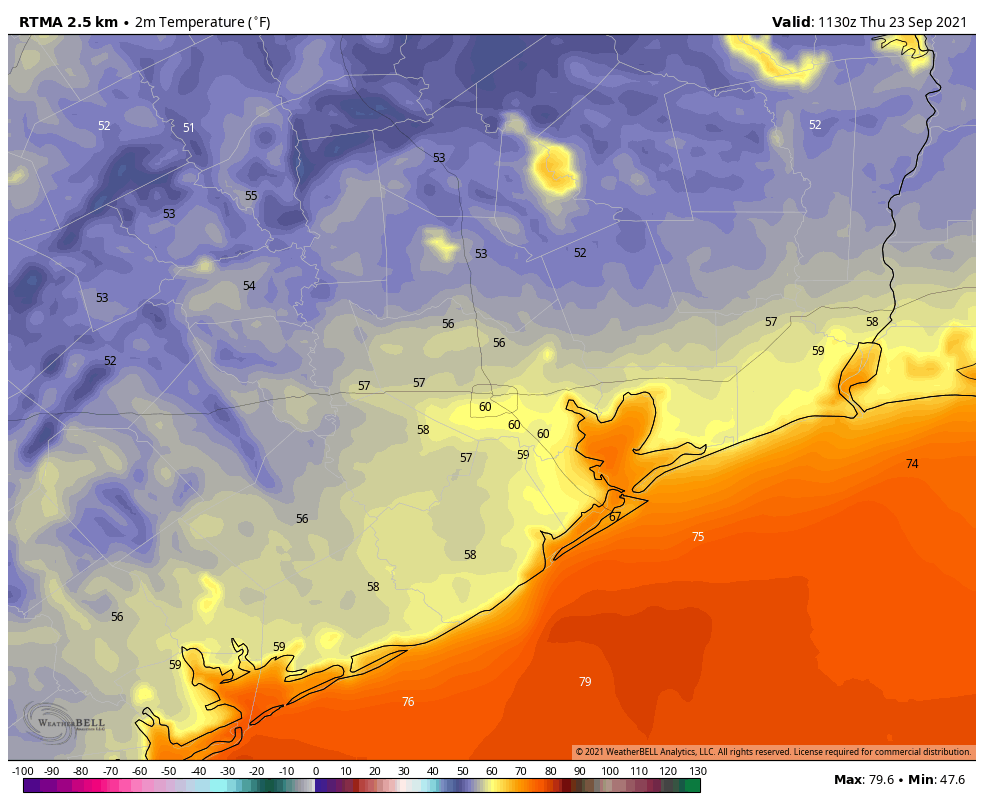
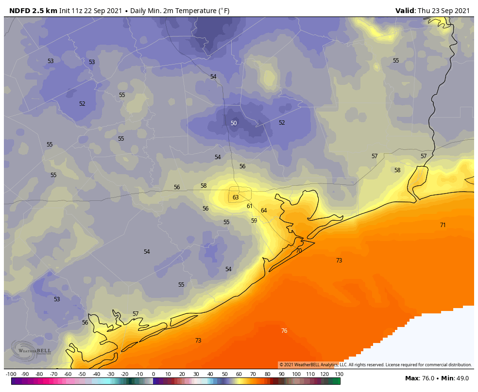
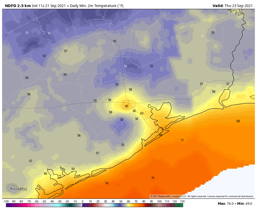
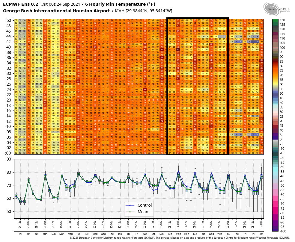
Our official morning low at IAH Airport was 57° yesterday and 58° today, the coolest pair of back to back days since late April or early May. We are now on the “other side” of things in the wake of the cold front, which means that, while it will still be quite nice the next couple days, it will begin to warm up a bit.

Today & Saturday

Both days look mainly sunny with light winds and comfortable humidity. Look for highs in the mid-80s and nighttime lows inching back into the lower or middle 60s.

Sprawling high pressure dominates the eastern half of Texas and most of the southeast third of the U.S. this morning (NOAA)

As high pressure gradually slips to our east, we will see onshore winds gradually return here, which means humidity will inch back up just a bit also by tomorrow.

Sunday

The end of the weekend will mark the true transition back to more late-summer weather. Expect continued sunshine and a morning low in the mid-60s (warmer at the coast), followed back daytime highs in the mid to upper-80s with a bit more humidity.

Monday & Tuesday

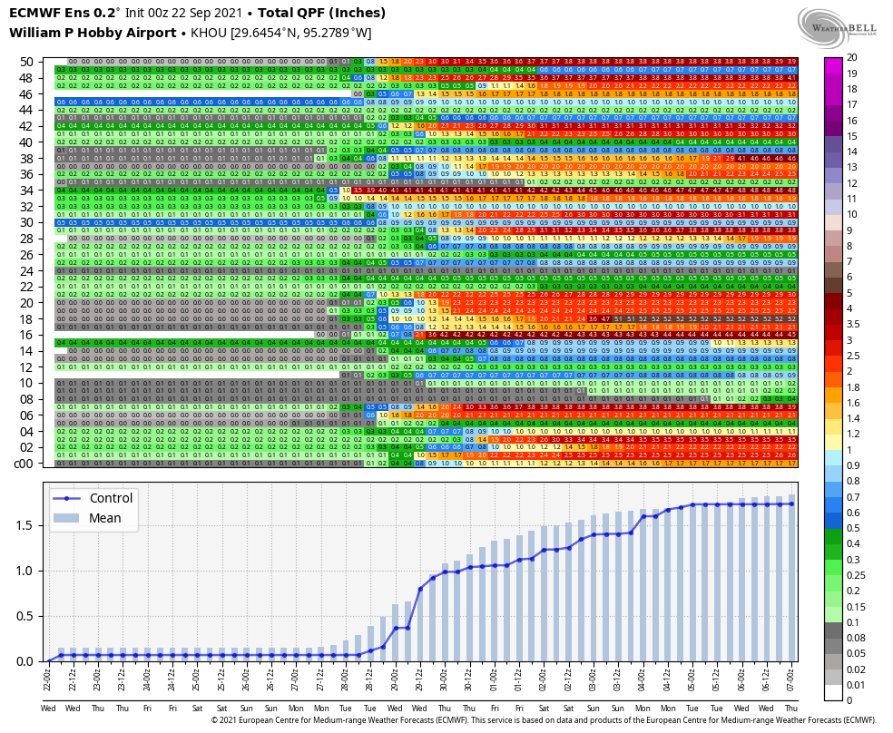
Weather models had been pretty aggressive with bringing rain back to the area next week. For Monday and Tuesday at least, that doesn’t seem too likely. Yes, there will be shower chances on both days, but the setup initially looks kind of mediocre, with probably just a few showers and generally lighter rainfall totals by the end of Tuesday. We will see clouds and plenty of humidity though. Look for highs near 90 degrees and lows in the 70s.

Wednesday & Thursday

The middle to late part of the week may see just a little more support for showers, so rainfall could be a bit more noticeable then. Highs will be contingent on cloud cover and could exceed 90 with enough sunshine, but we’ll generally call for upper-80s or a little cooler with more rain showers.

Generally about 1 to 2 inches is expected on average next week, with perhaps a lean toward the lower end of that range in the Houston area. (Pivotal Weather)

Overall, we aren’t especially excited about this setup for rain next week. Given the models maybe backing down some today, it looks like an average of 1 to 2 inches is most likely across the region. The highest amounts may be south and west of Houston. Some of you may see less than an inch too. More on this for you Monday.

Late next week

Weather models have been at least hinting at some kind of cold frontal passage later next week for a few days now. It’s too early to get too specific, but I think the evidence points to a couple things right now. First, the “front” will probably not be like this week’s front in that we aren’t going to turn significantly cooler behind it but rather a little cooler but a good bit less humid. I wouldn’t expect 50s for lows right now, but we’ll see.

When you look at the 51 members of the European ensemble late next weekend, most imply some kind of cold front passing through, but none show a particularly significant front. (Weather Bell)

Second, the timing of the front would be probably next Saturday or Sunday, so most, if not all of next week looks humid. Could all this change? Certainly. We’ll see how things go over the next few days and report back to you next week on what’s happening. So, soak up the next day or two if you like autumn weather.

Tropics

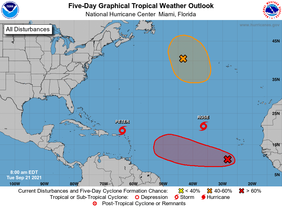
I want to just append a quick note on the tropics today because yesterday morning we had Tropical Depression 18. This morning we have Hurricane Sam. Sam has rapidly intensified into a hurricane out in the open Atlantic.

Hurricane Sam will continue intensifying into a major hurricane over the next few days, which should also help keep it north of the Caribbean islands. (NOAA)

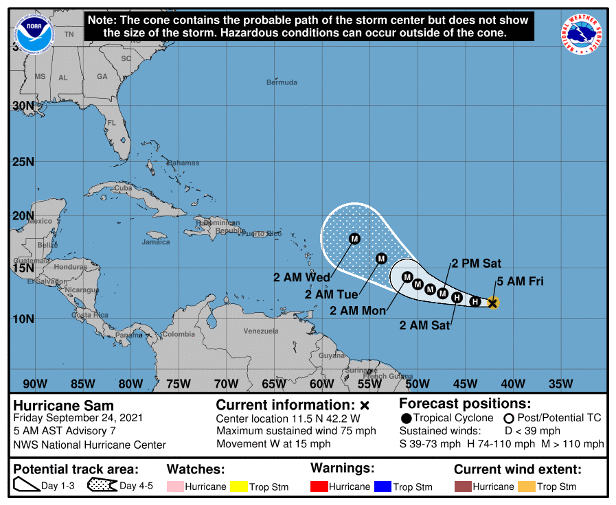
Sam is expected to become at least a strong Category 3 storm over the next few days which will also help it probably track a little more to the north than it appeared a couple days ago. This should hopefully bypass the Caribbean islands entirely and then turn north and out to sea, though Bermuda may need to keep an eye on Sam. Otherwise, as Eric noted yesterday, at least the Gulf should remain trouble-free.

Have a great weekend!

We think the Texas hurricane season is probably over

It’s a strange time a year. The historical peak of the Atlantic hurricane season came fewer than two weeks ago. Moreover, a little more than a week ago, Hurricane Nicholas struck the Texas coast and knocked out power for hundreds of thousands in the region. And today, Space City Weather is saying hurricane season is probably over for Texas? Really? Why yes. Yes we are.

There are a couple of reasons for this. Historically, the odds of a hurricane striking the state of Texas are about 1-in-50 after September 24. Our confidence is increased this year because, looking ahead at the next 10 days, the western Gulf of Mexico looks pretty quiet, especially north of the Bay of Campeche. This is the time of year when the jet streak starts a seasonal swing southward, and our region becomes more prone to cold fronts, which push any tropical systems in the Gulf of Mexico to the east. We’ve already seen one weak front about 12 days ago, a stronger one yesterday, and there’s perhaps another front coming early in October.

All of this means that we’re pretty confident that Texas is not going to get hit by another hurricane this year, even though the “Atlantic season” runs through November 30. We may very well still see tropical mischief, in the form of a depression or moisture that sparks some heavy rainfall. But the blowy, storm-surge stuff—we’re probably done with worrying about that for 2021. As always, we’ll keep an eye on the tropics. But you don’t have to if you don’t want to.

Your sunrise temperatures on Thursday morning. (Weather Bell)

Thursday

There’s not a whole lot to say about our weather other than it’s gorgeous. Lows this morning range from the 50s inland to about 70 right along the coast. Today will bring more dry air, with light easterly winds, sunny skies, and highs in the mid-80s. Lows tonight will drop into the low 60s.

Friday and Saturday

Expect more of the same. Highs in the 80s. Sunny skies. Mostly dry air.

Sunday

The second half of the weekend should see continued sunny skies, but dewpoints are going start climbing, and so while temperatures remain in the 80s it will start to feel a touch more humid. Lows Sunday night will be notably warmer, likely only dropping to around 70 in Houston.

Skies will be mostly sunny this week, before turning mostly cloudy next week. (Weather Bell)

Next week

Much of next week will be something of a return to summer-lite weather, with highs near 90 degrees, lows in the low 70s, and lots of clouds. As the influence of high pressure lessens, we’ll open back up to moisture from the Gulf of Mexico, and rain chances will increase to perhaps 50 or 60 percent each day. As a rough guess I’d say much of the metro area sees 1 to 3 inches of rain total, or thereabouts. But it’s still too early for any precision. The models are starting to hint at a front in the Friday or Saturday range of next week, but there are certainly no guarantees.

Happy Fall Day, Houston!

This is my second favorite post of the year to write—that fall’s first real front has finally arrived in Houston. (Tomorrow, I plan to write my favorite). Not only will we see drier and cooler air, one of the pleasant surprises of this front is its sticking power. We should see about four days and notably cooler nights before humidity levels start to creep up on Sunday. More typically, our first fall front washes out within a couple of days. So let’s enjoy!

Wednesday

Dewpoints have generally fallen to the upper 50s this morning, and should fall further throughout the day. Accordingly, the air will feel much drier. With lots of sunshine, temperatures will quickly warm to the mid-80s this afternoon, but drop again as the Sun sets. Winds will be out of the north from 10 to 15 mph with higher gusts. Overnight lows will vary widely, from about 50 degrees in Conroe to 70 degrees right along the coast, in Galveston Island.

Thursday morning’s low temperatures are going to be sublime. (Weather Bell)

Thursday and Friday

More of the same: Sunny skies, highs in the low- to mid-80s, and cool nights down in the low 60s in Houston, and cooler for outlying areas.

Saturday and Sunday

The weekend looks a bit warmer, with highs in the mid- to upper 80s, but there should still be enough dry air to keep conditions pleasant, especially on Saturday. Skies will be sunny, and rain chances near zero. Plan outdoor activities with confidence.

Houston’s rain chances are zero until next Tuesday or Wednesday, after which a wetter period may return. (Weather Bell)

Next week

As the onshore flow really returns on Sunday, we’ll start to see dewpoints climb, and we’ll get back to late summertime weather with highs near 90 degrees. Rain chances should also start to increase by Tuesday or Wednesday as atmospheric moisture levels rise, along with lots of cloud cover. Most of next week will probably be warmer and muggier.

Scattered storms possible this evening as a cold front moves in

Houston’s first “real” front of the season is less than 24 hours from pushing through the metro area. So after one more hot and sultry day, Houston will see several days of cooler and drier weather. If you live north of Interstate 10, a couple of nights in the 50s are a possibility. At least somewhat drier air should remain with us through the weekend.

Tuesday

The high temperature on Monday reached 95 degrees at Bush Intercontinental Airport, and highs will be similar today across the region with sunny skies and light southeasterly winds before the front arrives. A broken line of showers and thunderstorms should reach areas north and west of Houston, such as Katy and Conroe, around 6 to 8 pm. This line will push through the metro area shortly after sunset, and reach the coast by or before midnight. These showers will be advancing from northwest to southeast fairly rapidly, and could bring some briefly heavy rain and lightning. If you have outdoor plans this evening, please have a place to find temporary shelter. Drier air will move in overnight, behind the front.

Tuesday’s high temperatures will be August-like. (Weather Bell)

Wednesday

This is the good stuff. We’ll wake up to temperatures on Wednesday morning generally in the 60s, with much drier air. Winds will be out of the north at 10 to 15 mph, with sunny skies. Highs will get into the low 80s. Lows Wednesday night will probably be the coldest of the week for many areas, dropping into the upper 50s for inland areas, with around 60 in the city of Houston.

Thursday and Friday

One nice thing about this front is that it should have some sticking power. We expect dry and pleasant conditions to continue through the work week, with highs in the 80s, and lows in the 60s for most of the region. Dewpoints should remain below 60 degrees until at least Saturday, which means the air will not feel sticky. Skies will be sunny, with a near zero percent chance of rain.

Thursday morning’s low temperatures will not. (Weather Bell)

Saturday and Sunday

At this point it looks like the onshore flow won’t really get going until later Saturday or Sunday, which should allow Houston to enjoy a fairly nice weekend, with highs in the 80s and still enough dry air to make a nice contrast with summer-like weather. Skies will remain mostly sunny, with no rain.

Next week

Our gradual warmup will continue at least into Tuesday or Wednesday of next week. At that point it’s possible we may see temperatures recover to about 90 degrees, and our first real rain chances won’t return until that time. Bottom line: We’ve got nearly a week of fine, early fall weather. I suggest you enjoy it.

Tropical outlook for Tuesday morning. (National Hurricane Center)

Tropics

The Atlantic tropics are popping with activity, but there’s nothing that poses an immediate threat to the Gulf of Mexico or, indeed, any landmasses. The red “X” may eventually become a threat to the Caribbean isles, or it may recurve north before doing so.