The Gulf storm: What to expect, and when to expect it

Before jumping into the updated forecast, I want to remind new readers of the ways in which they can get notified of our posts on Space City Weather:

  • Download our free mobile app for Android and Apple devices
  • Receive all posts by email, using the “Subscribe via email” form on the right side of this page (desktop version) or bottom (mobile version)—we’ll never spam you
  • Follow us on Twitter, Facebook, or Instagram
  • Read our website translated professionally into Spanish at Tiempo Ciudad Espacial

Ok, now on to the forecast. With this evening’s post we are going to give a general sense of the timing for what to expect, and when. We have some answers about the near-term forecast through Monday, but the bigger and perhaps more important question concerns what comes in the middle of the week.
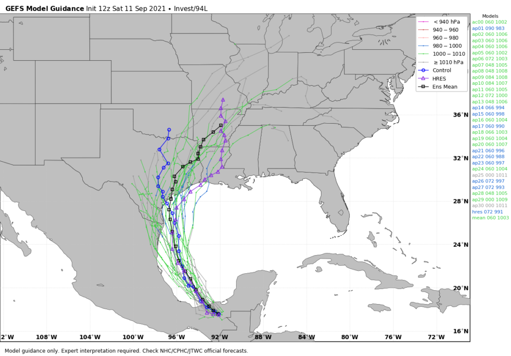
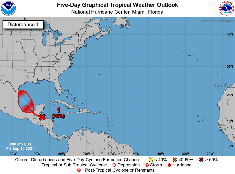
The GFS ensemble forecast provides insight into the range of possible outcomes for the track of Invest 94L. (Weather Bell)

Invest 94L

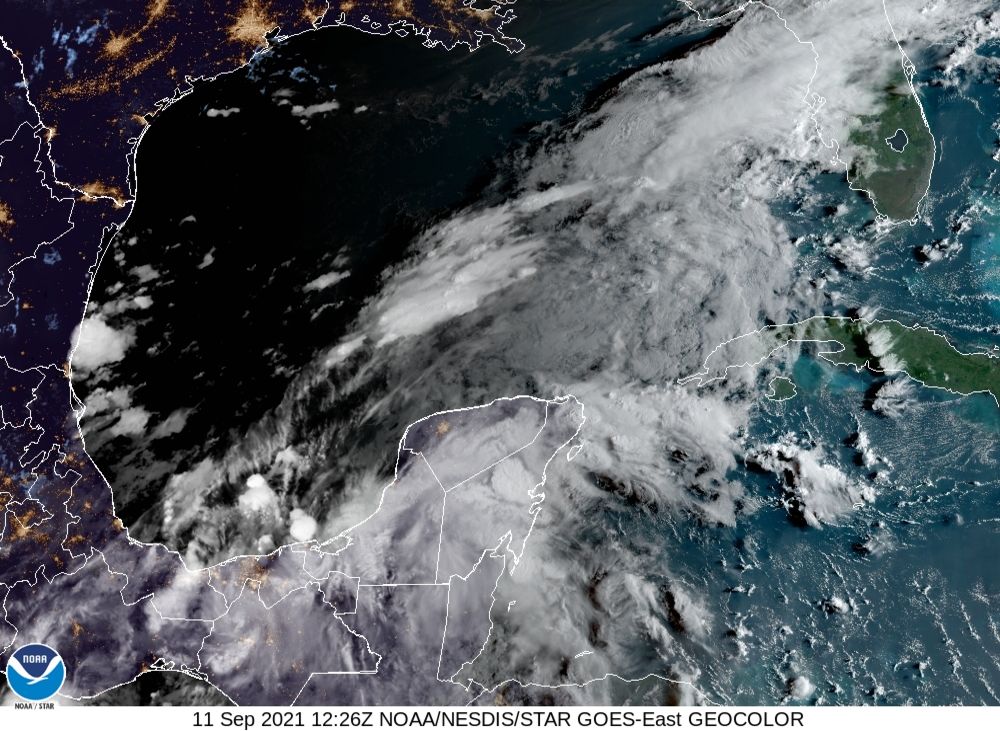
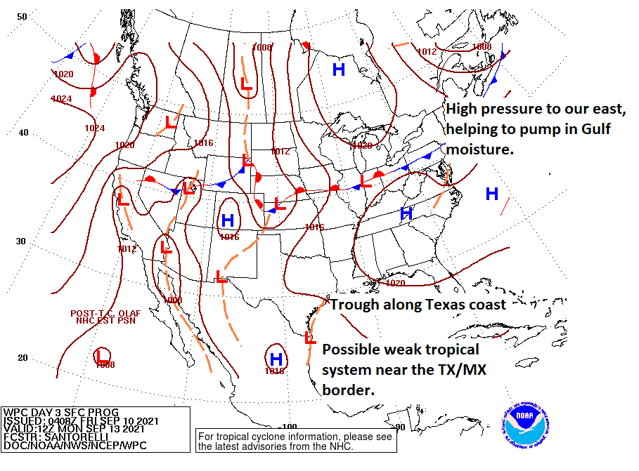
As of Saturday afternoon, the Gulf storm, or Invest 94L, remains poorly organized (see for yourself). It is difficult to assign a center to the low pressure system, and this lack of definition is one reason why forecast models are struggling a bit. However, the overall picture seems fairly clear. As the system moves northwest across the Bay of Campeche, it is likely to become better organized on Sunday, and should become a depression by Sunday night or Monday. By that time it should be approaching the northern Mexico or southern Texas coast. After this things the forecast becomes murky. By Monday night or so, the system may either move inland near the Rio Grande River, or turn northerly and track up the Texas coast. If it remains offshore, Invest 94L has a chance to become a reasonably strong tropical storm on Tuesday.

Sunday

Skies should remain mostly clear overnight, but clouds will begin to build across the upper Texas coastal region on Sunday. However, for much of the day any showers and thunderstorms we see should be scattered in nature.

Monday and Monday night

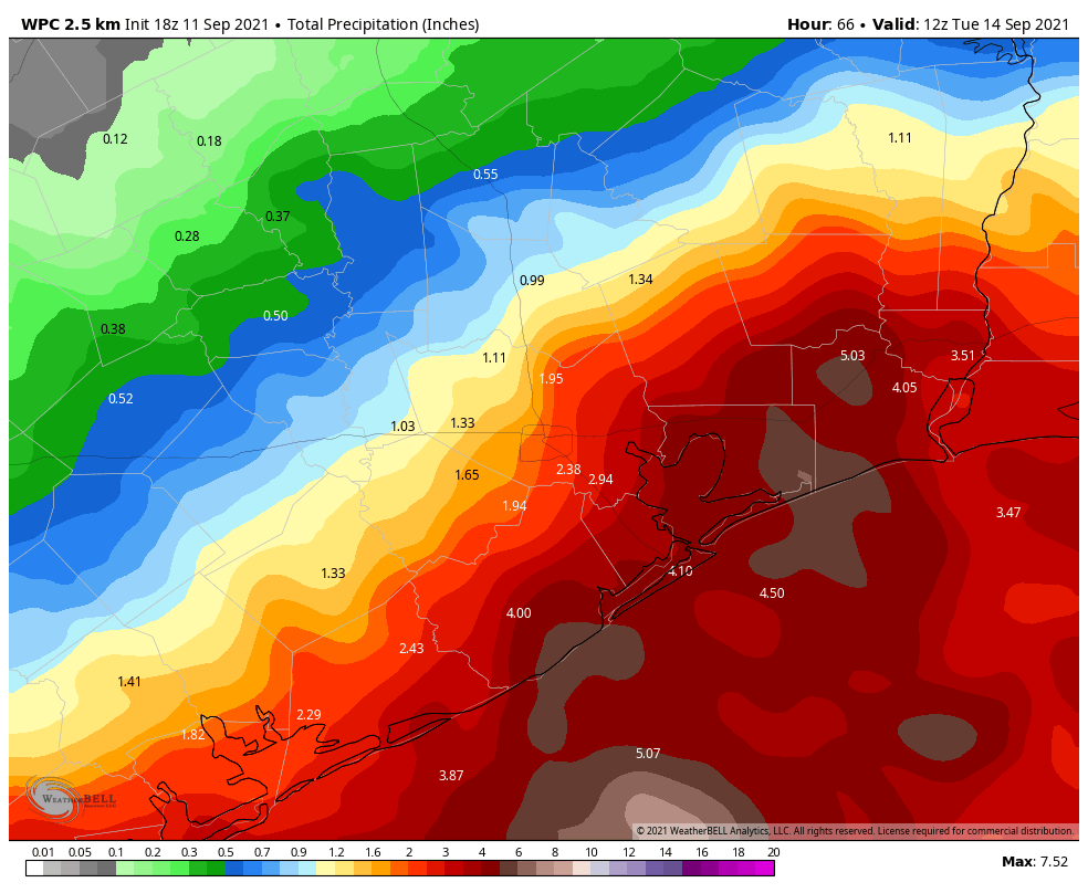
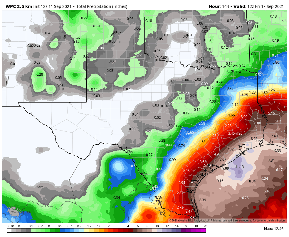
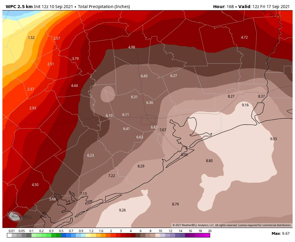
By Sunday night or Monday morning we should start to see more organized storms moving in from the southeast, off the Gulf of Mexico. It’s important to note these rains will not be directly related to the core of Invest 94L, which will remain far to the south. However, as a slug of moist tropical air moves inland we should see widespread accumulations of 1 to 3 inches for inland areas, and 3 to 5 inches of rain for coastal counties. We can’t rule out some bullseyes of 7+ inches. It seems possible that this initial round of storms may wind down on Monday evening or over night.

NOAA rainfall forecast for now through Monday night. The key is what comes afterward. (Weather Bell)

Tuesday and Wednesday

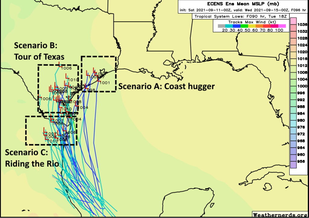
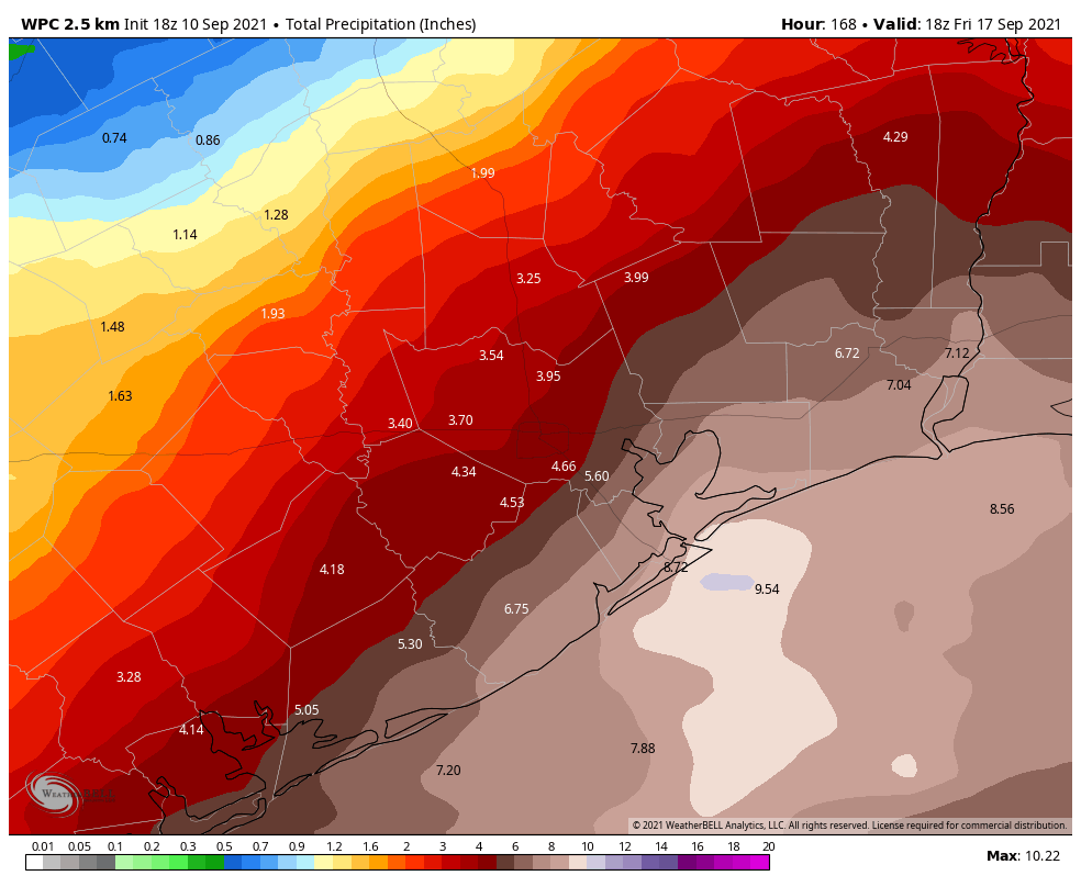
The real question is what comes after this point, and that will be determined by what the center of Invest 94L does. If the storm’s core moves up the Texas coast (the “Coast hugger” scenario in this morning’s post), our region would probably see manageable rain totals on Tuesday and Wednesday, with the heavier rains offshore or falling over southwestern Louisiana. However if the low moves into Texas and then wanders upward through state—perhaps along the Highway 59 corridor or further inland as in the “Tour of Texas” scenario—we could see a second round of even heavier showers on Tuesday night and Wednesday. For now, it is impossible to say which of these situations will play out, but ultimately this is probably the most important thing to watch in terms of flooding for the greater Houston region. If we’re going to get rocked, it probably would come then.

Our confidence is reasonably high that the rainfall event, whatever comes our way, will begin to wind down on Wednesday afternoon or evening.

Matt will have a full update in the morning, and we’ll have all-hands-on-deck coverage with myself, Matt, and Maria tomorrow.

Tropical system moving into Gulf, heavy rains likely next week

Good morning. It’s going to be a beautiful Saturday in Houston, in early September. We totally understand that people are focused on 9/11 remembrances, family gatherings, or other activities today. But there is a potentially serious weather situation developing in the Gulf of Mexico that you need to keep one eye on this weekend. I say potentially because there are some scenarios in which Houston sees only moderate rainfall, and there are others in which we get drenched.

The satellite appearance of Invest 94L at sunrise on Saturday is not overly impressive. (NOAA)

Here’s what we know for sure: It is highly likely that a tropical depression or storm will form over the southwestern Gulf of Mexico within a day or two. This extremely moist system will bring heavy rains, winds, and high seas to the Texas coast beginning late on Sunday. But it’s the details that matter, and we can’t pin those down yet. Based upon the latest modeling and the atmospheric setup, I want to present three plausible scenarios for the next week. As we will discuss, the effects range from mild to extreme, and that’s one reason why it is so difficult to provide an accurate forecast at this time.

Three scenarios

The map below shows the European model’s ensemble forecast for the evolution of the tropical system, which has been designated Invest 94L. It shows tracks from Friday night through Tuesday evening, and I’ve boxed what I consider three of the most likely possibilities. Let’s discuss each of them.

Three potential scenarios for Invest 94L. (Weathernerds.org/Space City Weather)

Scenario A: Coast hugger

In this case the storm moves close to the Texas coast on Monday, but perhaps doesn’t come fully ashore. It then moves fairly rapidly to the north and then northeast, bringing its center close to the Houston metro area on Tuesday or Wednesday. In this case we would see higher tides—although probably not too great of a storm surge—and wind gusts of tropical storm force in the metro area. However, the heaviest rainfall would likely fall off the Texas coast and potentially in southwestern Louisiana. In this scenario Houston might see 2 to 4 inches of rainfall, with the 20-inch bullseye remaining offshore.

Scenario B: Tour of Texas

In terms of rainfall, this scenario is more ominous. A likely weak tropical storm would move into South Texas on Monday or so, and slow down for a couple of days. The center would remain close enough to the coast that the storm would be able to tap into Gulf of Mexico moisture. In this case, Houston might expect 5 to 15 inches of rain, with a 20-inch bullseye of rainfall coming somewhere in the area from Corpus Christi to Beaumont. But it’s impossible to say where. The potential for heavy rainfall would linger through Wednesday. Winds and seas would be much less of a factor.

Scenario C: Riding the Rio

It still is possible that the low moves into northern Mexico and basically tracks along the Rio Grande River, dying out after a few days of being inland. In this case the Texas coast would see some moderate rainfall for a few days, but totals for most areas would probably be 2-4 inches, or even less. This scenario seems a little less likely at this time, but it would certainly have the most benign effects for Houston.

This is the latest six-day rainfall forecast from NOAA, but it is only a very rough guide, and localized amounts could be much higher. (Weather Bell)

Conclusions

So what actually happens? I wish I could tell you. But we’re talking about a tropical wave that has yet to form a semblance of a circulation, so the forecast models are going to struggle with its track. After that, it’s not entirely clear how much the wind shear currently hampering its organization will weaken over the next couple of days as the system moves northwest or north toward Texas. And these are just the beginning of our questions.

The bottom line is that Saturday should see fine weather in Houston. Sunday should start out sunny as well before rain and thunderstorm chances increase during the afternoon and evening hours. After that heavy rainfall is possible through Wednesday, and we just really can’t say how much. But this is a forecast you should be monitoring closely. We’ll have an update later this afternoon or evening.

Houston faces a Stage 2 flood alert beginning Sunday evening

To set expectations for next week’s heavy rains, we plan on implementing a Stage 2 flood alert on our flood scale, and anticipate this warning will be in effect from Sunday evening through Wednesday. This is what we mean by Stage 2 on our five-point flood scale:

Events falling into this category may cause significant, widespread street flooding across large swaths of the area, flooding numerous cars. Other examples of what we would consider stage 2 events are ones that flood dozens of homes in small, targeted areas or specific neighborhoods. These events are either moderate impact over a large area or high impact over a relatively small area.

A couple of notes on this before we jump into the forecast. First of all, it is quite early to be calling for this, as heavy rain is unlikely to arrive before Sunday night at the earliest. However, since most people probably will check out over the weekend—much of which will be sunny and pleasant—we wanted to give our readers a heads up now. Second, since we are issuing this flood alert early, it is very much subject to change. And finally, the area of greatest risk lies south and east of Houston, so that’s where we think Stage-2 like effects are most likely.

As to the overall forecast, not a whole lot has changed. There remain a number of meteorological variables that we can’t yet predict with great precision, and so the forecast models are struggling with rainfall totals. For example, a model might forecast 15 inches of rain for a location in one run, and drop to 5 inches the next run.

There is fairly good consistency, however, on the overall setup favoring heavy rainfall somewhere in Texas or Louisiana. (Or both!) So if you live within 50 miles of the coast, between Corpus Christi and Lake Charles, you’re potentially under the gun. In terms of accumulations, we anticipate 2 to 6 inches for most locations, but what we’re concerned about is potential bullseyes of 10+ inches. It looks like the most likely period for heavy rainfall will run from Monday through Wednesday.

NOAA rainfall forecast for now through Thursday. (Weather Bell)

The bottom line is this: Enjoy your weekend, but also be prepared for the possibility of heavy and potentially disruptive rainfall early next week.

We’ll update on Saturday and Sunday with the latest.

Sunshine rules before a somewhat complex soggy situation next week

For some folks, today is the coolest morning in months! Crockett, for instance, is down into the 50s. IAH, at least as of 6 A.M. has not gotten under 70 just yet.

Temperatures this morning (6 A.M) have a huge range from the mid-80s in Galveston to low 60s in northern Montgomery County and areas northeast of Houston. Houston itself ranges from around 70 north and west to the mid 70s south and east. (NOAA)

We will see if we can match our cool day of the week (69° on Wednesday) or even sneak just below it before the sun gets up. Either way, it’s comfortable out there today, and we’ll be closing the week on a very high note. Enjoy it, because things will begin to change in earnest later this weekend. We detail the situation below. Look for a post later today that will set our initial Flood Scale expectations for next week.

Today

No issues whatsoever. It’s beautiful. Enjoy it if you can. We will see highs peak in the 90s with abundant sunshine and rather comfortable humidity.

Saturday

While Saturday morning won’t start off quite as cool as we are this morning, it should still be a pleasant start to the day, with morning lows ranging from the 60s inland to 70s near the coast. There is even a chance that Galveston checks in cooler tomorrow than it did today. Look for more sunshine, highs in the 90s, and perhaps just a tinge higher humidity.

Sunday

The end of the weekend will bring the beginning of our transition into the wet period we’re expecting. I would expect at least a chance of thunderstorms in Houston and south of I-10 with increasing clouds elsewhere. Morning lows in the 70s will warm into the upper-80s or low-90s depending on how much sun you see. No serious problems are currently anticipated Sunday, but if you have outdoor plans, keep the rain chances in mind.

Next week

So let’s talk about next week. There are a number of factors that will go into exactly how next week plays out, some of which are rather low confidence still today. But in general, expect increasing rain chances Sunday through Wednesday, with locally heavy rainfall and potential for at least some flash flooding concerns, especially south and east of Houston and along the coast. Let’s walk through some of the players and how they will influence what happens next week.

First, the primary reason next week looks wet: High pressure over us today will leave us to the east over the weekend, steering Gulf moisture back into the area. The remains of our cold front offshore transition to what we call a surface trough. And then you may add a tropical system to the mix in northern Mexico or far south Texas. You can see this all reflected on a forecast surface map below.

With high pressure to our east opening the door to Gulf moisture, a lingering surface trough on the coast and potential weak tropical storm or depression will help determine exactly how much rain we see and where we see it. (NOAA)

Confidence is relatively high that the high pressure area will move to our east and open the door to Gulf moisture. So that much we know. Where confidence drops is in relation to possible tropical development off the Mexico or Texas coast.

The National Hurricane Center has lifted odds of tropical development to 70 percent over the next 5 days in the Bay of Campeche. (NHC)

Odds have been increasing that whatever moves into the Bay of Campeche this weekend will develop into a tropical depression or weak tropical storm. That’s one thing we have moderate to high confidence in: That this system has a rather low ceiling in terms of intensity. It should track along the coast and north, probably making landfall in northern Mexico or far south Texas on Monday sometime.

This will matter some, however because the exact location of the track and how well organized this disturbance is will help dictate where the highest rain chances are located and how high the totals will be. These situations are not straightforward. Sometimes you’ll see the heaviest rain hug the coast or just inland and cause flash flooding problems. Other times the heaviest rain will fall offshore and end up mostly harmless for coastal communities. We just don’t know at this point exactly what it will look like.

Here’s what I think we can say right now, with some level of confidence:

  • We will have periods of thunderstorms beginning later Sunday and continuing into Tuesday or Wednesday of next week.
  • It won’t rain the entire time, and there may be some substantial breaks in the rain, especially north of I-10.
  • Rain will likely be heavy at times however, especially along the coast and possibly south or east of Houston.
  • Localized street or flash flooding is possible, especially south and east of Houston, but it is too soon to tell you exactly where and when that may occur.
  • Rain totals of 2 to 6 inches on average for most of the area between Sunday and Wednesday, with the highest totals in smaller pockets south and east of Houston, perhaps up to 8 to 10 inches or even more.
  • While tropical development is becoming increasingly likely, we do not expect this to be a wind or surge issue for us. Some rough seas, rip currents, and elevated tides will be possible, but development should remain weak enough and far enough to our south to avoid the wind & surge problem. This will be almost exclusively a heavy rain situation for us.

Here is the current NWS rainfall outlook into next week.

Rain totals in excess of 6 to 8 inches will be possible south & east of Houston and along the coast early next week. (Weather Bell)

While some areas will probably see less rain than forecast above, their placement of the bullseye totals south and east of Houston is logical right now, and higher amounts are possible in those areas.

Drier air and lower rain chances should begin to build in after Wednesday.

After we digest the morning weather model data, look for a post from Eric later this afternoon that will initiate our Flood Scale outlook for this event. And we’ll keep you posted over the weekend.