Good morning. Houston should remain in a drier pattern through the first half of the weekend—Friday evening through Saturday morning looks especially pleasant—before much wetter weather arrives by Sunday. As tropical moisture increases, so will rain chances, and we’re tracking the potential for heavy rainfall from Sunday night through the early part of next week.
Thursday
The next weak front is located north of the metro area, but should slide into the region today. There will be a subtle shift in winds from the northwest to the northeast, but skies should remain sunny regardless. Accordingly highs will be toasty today, likely reaching the mid-90s, with the possibility of a few locations seeing the upper 90s. Lows tonight will drop into the low 70s in Houston, with the potential for upper 60s further inland.
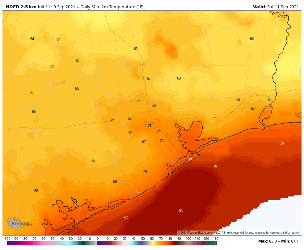
Saturday morning’s low temperatures will be fine for mid-September. (Weather Bell)
Friday and Saturday
This looks like a pretty stunning period, at least as September goes, through about Saturday evening. The driest air should push into the region on Friday, with the potential for dewpoints to drop into the 50s. Expect daytime highs around 90 degrees, with sunny skies, and lows Friday night in the upper 60s across much of Houston.
Saturday night through Monday
The period turns sharply wetter with the arrival of tropical moisture beginning Saturday night or Sunday morning. The overall threat is still not particularly well defined, but a tropical wave should move into the southern Gulf of Mexico this weekend, and associated moisture will push into the Texas coast. The forecast models are hinting at some significant rainfall totals from this, especially for locations closer to the Gulf of Mexico. For now, as a guess, we’re probably looking at rain totals of 3 to 5 inches south of Interstate 10, with lesser amounts inland through early next week. Our main concern is the potential for higher localized rain totals. It’s impossible to say where that will happen, but the potential is there.
After Monday
A fairly wet period should persist into the middle of the week, with sunnier weather potentially returning by Thursday or so. Until that time highs will only be around 90 degrees, with muggy nights in the upper 70s. Those deliciously low dewpoints will be long gone.
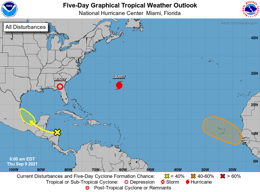
It’s September 9, so as usual there is a lot of activity in the tropics. But for the western Gulf of Mexico we need only concern ourselves with the aforementioned tropical wave. This feature, which we’ve mentioned several times this week, is now given a 30 percent chance to develop into a tropical depression or storm by the National Hurricane Center. The most likely outcome is that the system will move into the Mexico coast, or possibly south Texas, but we can’t entirely be sure of that yet. In terms of the overall rainfall threat early next week, it probably won’t matter too much.
Good morning. Most of Houston is experiencing temperatures in the upper 60s to lower 70s this morning, with modestly lower dewpoints. This is not exactly fall-like weather, but it’s a reminder that we’re much closer to fall than you might realize. Moreover, there’s another weak front on tap in a day or so to keep our “September-pleasant” weather in place for the rest of the week.
Wednesday
Today will be hot, as drier air allows the air to warm quickly into the low- to- mid 90s under sunny skies. Light northerly winds will shift to come from the east later today, and eventually the southeast. This will herald the return of somewhat muggier conditions later tonight as the first weak front washes out. As a result low temperatures Wednesday night may be a few degrees warmer than Tuesday night.
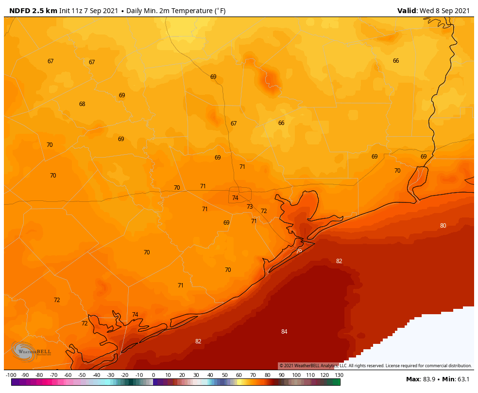
Low temperatures on Friday morning look nice. (Weather Bell)
Thursday and Friday
Another weak front will be on the move Thursday, however, and it should reach the coast by around noon or shortly thereafter. This one should have even a little bit more drier air with it. So while highs on Thursday will warm into the mid-90s beneath sunny skies, lows Thursday night should drop to around 70 in the city, with cooler temperatures in outlying areas. It will be nice. Expect similar conditions for Friday, which should see the driest air of the week.
Saturday
The drier air should hold into Saturday before our air mass becomes modified by the onshore flow. Still, I’m expecting mostly sunny skies for the first half of the weekend, with highs in the low- to mid-90s. Saturday night should be warmer and muggier.
Sunday and beyond
The party ends on Sunday as notably higher dewpoints in the mid- to upper-70s return to the region. Along with this we’ll see an abrupt shift in cloud cover and increasing rain chances. We still don’t have a great handle on rainfall amounts, but daily chances should be about 50 percent beginning on Sunday, continuing through much of next week. Highs will be around 90 degrees each day, with lows in the mid-70s.
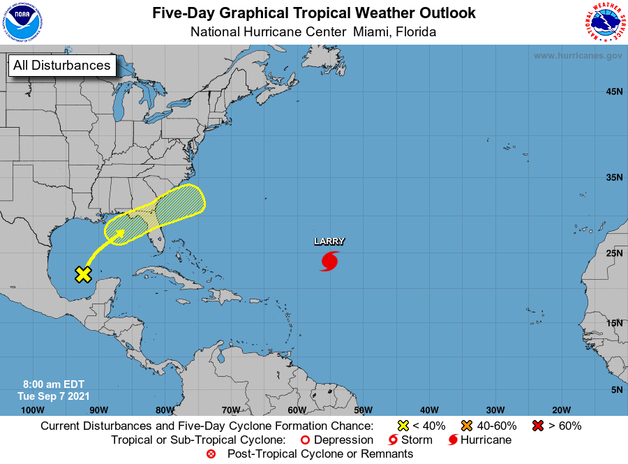
In the tropics we’re still tracking Hurricane Larry, which will avoid Bermuda and should gradually weaken as it lifts to the north. Closer to home, in the Gulf of Mexico, Invest 91L is moving toward the Florida Panhandle, where it has a 50 percent chance of becoming a tropical depression or storm before landfall. Regardless, it will make for a wet few days in Florida. Finally, we’re continuing to see the potential for a weak tropical system to develop in the Bay of Campeche late this weekend. However there is no real signal in the forecast models that this system will either develop further or move that much northward. Still, its moisture could play a role in our rainfall next week.
Good morning. After a hot and sunny weekend, with a splash of showers on Labor Day, Houston’s pattern will see continued sunny skies this week. The principal difference, however, will be somewhat drier air across the region that will bring some cooler nights. Areas well inland may even see some lows in the upper 60s for a few nights. Highs will remain toasty, however, with ample sunshine warming the drier air quickly. Rain chances are essentially nil until next Sunday.
Tuesday
The aforementioned dry air mass should move southward across the entire region, reaching the coast this afternoon or evening. As this happens. highs today will climb the mid-90s across the area, with sunny skies and light winds from the north. The real fun will start this evening, as the sun sets. The (modestly) drier air will make itself felt in the form of temperatures and dewpoints this evening and on Wednesday morning.
Lows on Tuesday night will be far from cold, but they’ll still be pleasant for early September. (Weather Bell)
Wednesday
This, too, will be a sunny day, with highs in the mid- to upper 90s, and winds becoming westerly later in the day. Humidity levels should begin to rise later on Wednesday, and conditions could become a little sticky overnight.
Thursday, Friday, and Saturday
Yet another somewhat drier air mass should move into the region on Thursday, or so, and this should set the stage for some more decently nice late summer weather. Look for sunny skies, highs in the mid-90s, and lows in the upper 60s for inland areas, low 70s in Houston, and a bit warmer along the coast. Again, evenings and mornings should be nice for outdoor activity.
Sunday and beyond
The dry pattern is going to break pretty emphatically by Sunday or Monday, as high pressure moves off, and our region becomes open to moisture from the Gulf of Mexico. Sunday may still be sunny and warm, but at some point cloudy and muggier weather will set in, and rain chances will go up. Our region, as a rough guess, may see 2 to 4 inches of rain next week week, with daily chances. We will of course have to refine this forecast in the days ahead.
Tropics
Texas has about two to three weeks during which we need to closely monitor the tropics, after which we should move into a more fall-like pattern. And the good news is that there’s really nothing to worry about over at least the next week. Right now we’re tracking an area of low pressure in the southern Gulf of Mexico that should eventually move toward the northeast Gulf of Mexico, bringing some rainfall to the Florida Panhandle later this week. Hurricane Larry is beginning to slowly weaken, and will hopefully turn north before affecting Bermuda.
Tropical outlook for Tuesday morning. (National Hurricane Center)
Finally, we may see some additional development in the Southern Gulf of Mexico in about a week or 10 days (not shown on the map above). This activity, possibly in the form of a tropical depression, may influence our rain chances next week. For now we’re seeing no indication of a strong tropical storm forming from this area, but at this time of year we’ll keep close tabs on it.
Happy Sunday everyone! We hope your weekend has been going well so far. The weather has certainly cooperated for the most part. The rest of today should behave similarly. We just wanted to post about a couple things since we sort of left the weather situation for the upcoming week on an open-ended note on Friday. We’ve gotten a good bit of clarity over the last couple days, which, as it turns out is good news for us.
This evening & Labor Day
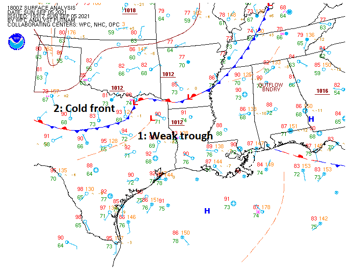
As noted on Friday, we do expect conditions to become a little more unsettled heading toward tomorrow. If we look at a quick surface weather map of the region, we can see the main players. First, we have a weak little trough (orange dashed line) dropping southeast across Texas today. That could focus a few showers and storms tonight, and this would primarily be north of Houston.
A weak cold front is going to act as a triggering mechanism for some additional showers and storms tonight and tomorrow. (NOAA)
The second item to note on that map is an actual cold front. Sadly, this isn’t going to be a classic autumn cold front, but this may be just enough to help lower humidity a little for the week ahead, particularly during the afternoon. Instead of nighttime lows in the mid to upper-70s, perhaps we’ll have a few mornings in the low to mid-70s this week. For those seeking that true pumpkin spice latte weather, this won’t be it, but it will be a start.
More importantly, this front will serve as a focal point for scattered thunderstorms on Monday. I would not be shocked if we have some activity in the morning and then a break with more in the late afternoon. Storms tomorrow afternoon could be on the strong side with locally heavy downpours. Just keep that in mind if you’ll be traveling to or from somewhere or hosting an outdoor BBQ. Probably good to have a backup plan for the BBQ, just in case. Outside of rain, it should again be in the 90s tomorrow.
Tuesday through Thursday
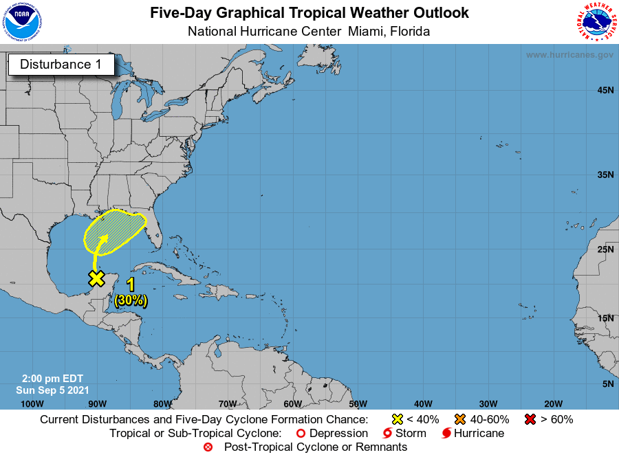
Back on Friday we told you about how models had gotten a little more excited about the potential of a tropical system in the Gulf. For us, some good news: Whatever “that” is should not develop much, and it will almost certainly miss well to our east.
Any tropical development in the Gulf this upcoming week will be on the weaker side and track to our east, keeping us most likely high and dry. (NOAA)
The National Hurricane Center is continuing to assign about 30 percent development odds over the next 5 days from Invest 91L, now emerging in the Bay of Campeche. But the upper level pattern will feature a strong ridge in the upper atmosphere that builds from about Las Vegas on Monday to the Four Corners on Thursday. That eastward expansion of high pressure in the upper atmosphere, combined with a pretty strong trough in the eastern U.S. will likely help deflect the tropical noise into the central or eastern Gulf. This leads our rain chances to drop in the Houston area Tuesday, Wednesday, and Thursday. Obviously we don’t want to see Louisiana face yet another tropical threat, but thankfully whatever does develop here (if anything does at all) should be weak. That said, some heavier rain is possible in the eastern Gulf from this system. As of right now, official forecasts are only about 1 to 4 inches, aimed mainly at Alabama and the Florida Panhandle.
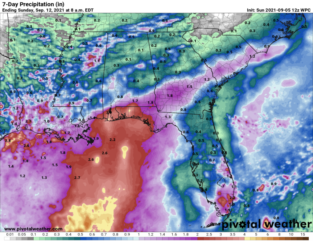
The official NOAA rainfall forecast over the next 7 days shows that Invest 91L is likely to deliver at least some heavy rain to the eastern Gulf and possibly some localized heavy rain in Louisiana as well. (Pivotal Weather)
Some locally heavy rain is possible in Louisiana from this, but the primary focus is likely to stay east of there as well. We’ll keep watching, just in case, but we feel fairly good about the upcoming week overall for the Houston area.
Beyond next week: Other tropical threats?
There have been some posts circulating on social media regarding various deterministic (singular) model runs showing a hurricane in the Gulf around mid-month. I’ll be honest, the operational GFS has been quite consistently showing a system (of varying intensity) in the Gulf around mid-month (sometimes in Mexico, sometimes in Texas, sometimes elsewhere). While the GFS ensemble has been, in this forecaster’s opinion, one of the best tools to use in the tropics to identify possible threats the last two hurricane seasons, the GFS operational model still has many flaws. This is especially true on a day 10+ forecast. I don’t care how consistent it has been showing a certain outcome: It is still a day 10+ operational forecast model, and it is *not* meant to be used with any specificity whatsoever. While it’s nauseating to deal with this stuff multiple times per hurricane season, it is the world we presently live in, and so let me be the one to tell you: At this time, you do not need to be worried about the threats shown on operational models that various, mostly anonymous Facebook pages are sharing.
Ensemble support for this system is not zero, but it’s not at a high enough volume yet where I begin getting concerned. And there is absolutely no dominant signal within the ensembles as to where such a system may or may not track even if it develops. Some show Mexico, some show Texas, some show east of here, some (roughly half) show no development at all! We see scenarios like this show up multiple times per hurricane season. Sometimes they lead to development. Often times, they do not. So, could this change? Absolutely, but sitting here today it would irresponsible to pump up the operational GFS model on day 11 without showing the ensembles at the same time which paint a less ominous picture. Let’s talk when it’s inside 7 days and see where we stand. It is the peak of hurricane season, so you should be checking in regularly anyway. But we see nothing exceptional at this very early stage.
Alright, that’s enough for now. Enjoy Labor Day if you’re able, and we’ll come back at you on Tuesday with the latest.