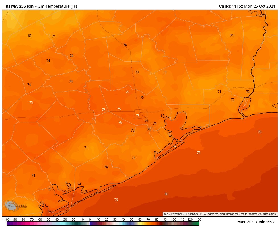
Houston will face some fog this morning as surface temperatures and dewpoints are essentially the same, in the low- to mid-70s. This sticky weather will abruptly change on Wednesday as a strong front moves through and brings breezy, cooler weather to the region. The weekend, including Halloween, looks absolutely spectacular.
It is a sticky morning in the mid-70s out there, y’all. (Weather Bell)
Monday
After the fog dissipates shortly after sunrise, today is going to be hot and sunny, with highs in the upper 80s to 90 degrees. Winds will be light, out of the west to southwest. Lows tonight won’t drop much below the mid-70s for most of the region. This weather is uncharacteristically warm for late October, but it’s not going to last.
Tuesday
This will be another sticky day, but the presence of a few more clouds should help to limit high temperatures to the mid- to upper-80s. Some rain chances will be possible during the afternoon hours along the coast, migrating inland during the evening. Any showers that develop should be light. Rain chances will be in the range of 30 percent. Overnight temperatures will remain warm as moderate rain chances persist.
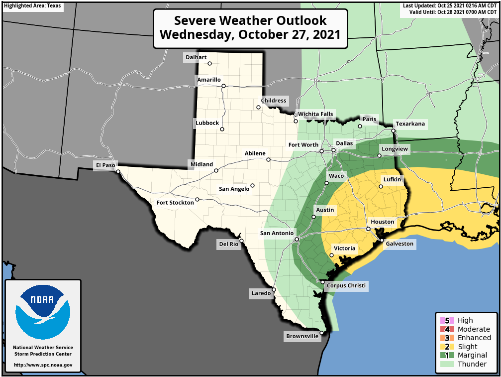
There is a slight chance of severe weather with the passage of Wednesday’s front. (NOAA)
Wednesday
It’s cold front day! As always there is a bit of uncertainty with the front’s timing, but it looks like a line of storms should reach the metro area around Noon. These storms could be briefly intense as they move from northwest to southeast across Houston, but should only last for an hour or less. Accumulations should be on the order of 0.5 to 1.0 inch of rain for most. Highs for most on Wednesday will be in the mid-80s, with the air becoming markedly drier behind the front. Lows Wednesday night should drop to around 60 in Houston, with cooler weather in outlying areas, and warmer conditions right along the coast.
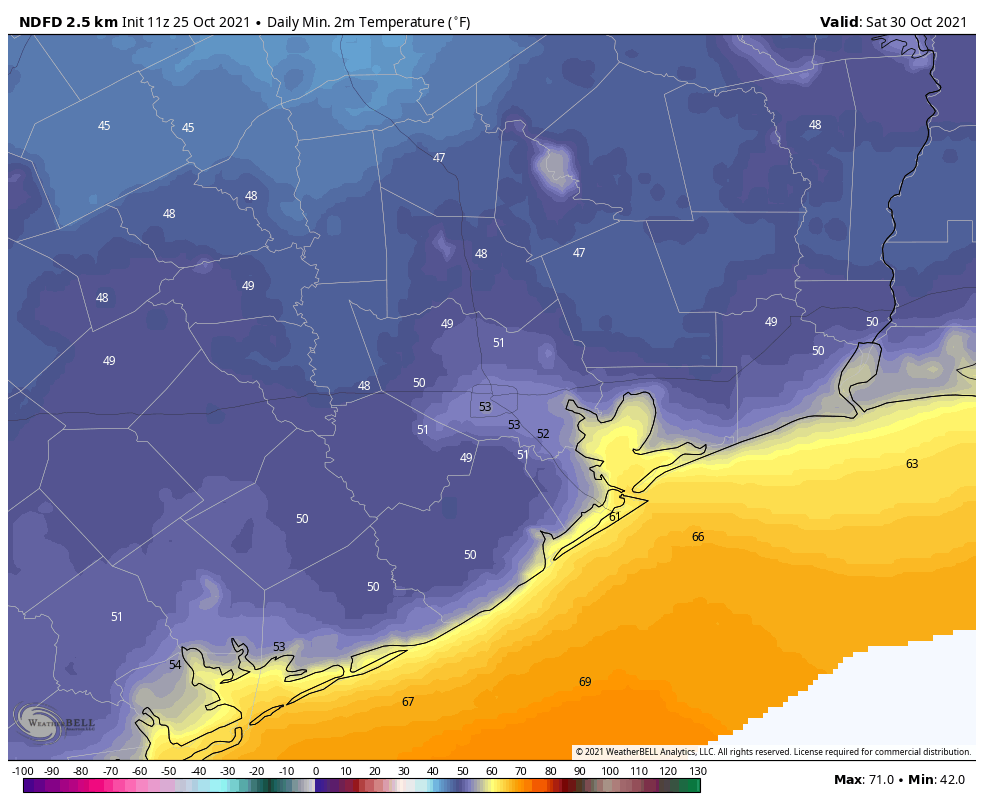
Thursday and Friday
These should be sunny, splendid days with highs in the 70s and lows in the 50s for much of the metro area, and 40s for some inland areas. It’s possible that these days are somewhat breezy, so that’s something we’ll be watching for.
Saturday morning looks like the coolest one of the week. (Weather Bell)
Saturday and Sunday
Plan your outdoor activities with confidence. Both days should see mostly sunny skies. Saturday should bring highs in the 70s, with Halloween possibly reaching 80 degrees. Although the onshore flow will return sometime this weekend, enough dry air should remain to make for pleasant conditions when trick-or-treating on Sunday evening. Enjoy!
The upcoming weekend will offer up a mixed bag of weather, featuring sun, clouds, some shower chances, and plenty of warmth and humidity. None of this should scare you away from whatever you were planning to do this weekend, though it will be warm! We still have a cold front in sight but not until midweek next week. That may possibly mean the end of “Second Summer” here in Texas.
Friday
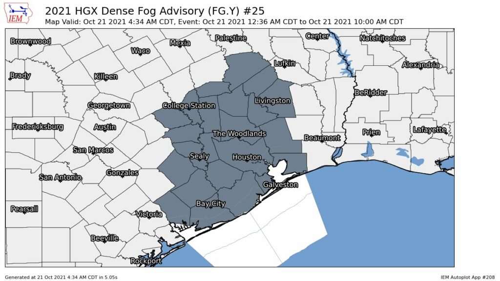
We have another round of dense fog in spots this morning, particularly outside Grand Parkway. Places like Sugar Land, Katy, and areas west or south of there toward Wharton or Lake Jackson, as well as east of Houston in Liberty County and toward Beaumont are all seeing visibilities under a half mile as of 6:45 AM.
Visibilities aren’t terrible in the city this morning, but outlying areas are seeing a lot of dense fog, particularly well east and southwest of the city. (NOAA)
That fog will dissipate over the next 2 to 3 hours, and today looks fairly similar to yesterday. Expect a mix of clouds and sun and temperatures generally in the 80s. An few showers can’t be ruled out, but rain would be the exception, not the rule.
Saturday and Sunday
As Eric noted yesterday, both weekend days will carry a chance of showers or a thunderstorm. Expect any showers to be fairly short-lived and really not too big a deal. Based on today’s model data, I think Saturday may have a slightly higher overall chance for rain than Sunday. Outside of that, just a mix of sun and clouds with warm, humid conditions. Winds should be generally light on Saturday and then a bit gusty on Sunday. Expect highs in the 80s and lows in the upper-60s or 70s.
Monday and Tuesday
Look for rain chances to ease back a little here, as we end up with continued warm onshore flow ahead of a cold front that will stay to our north but an atmosphere without much to set storms off. Highs will be in the 80s and lows in the 70s. Winds may begin to pick up a bit again on Tuesday.
Midweek and beyond
The cold front we’ve been discussing is still on track to arrive on Wednesday. Models have been in disagreement on how robust the storm chances will be with this front, but suffice to say there will be at least a decent chance of thunderstorms on Wednesday. We should know more about this on Monday. Behind the front, look for refreshing air with lower humidity and gusty offshore winds. That should set up a very nice back half of next week.
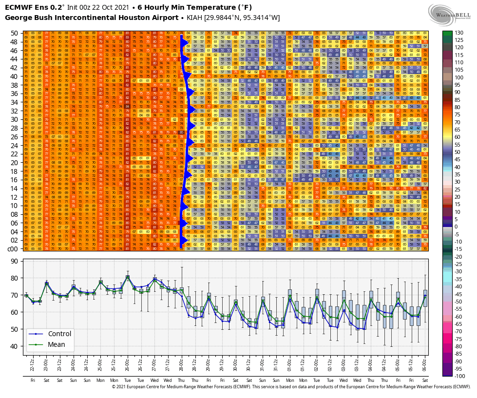
The European ensemble is consistent with a fairly strong cold front on Wednesday, but heading into next weekend and beyond there are enough mixed signals to suggest at least a more variable weather pattern may develop over Texas. (Weather Bell)
You can see from the chart above of European ensemble forecast low temperatures over the next 2 weeks that there is a rather mixed signal after next week’s front. Some ensemble members warm us back up, while others keep us cool. The overall weather pattern across North America may be shifting a bit to allow more frequent cold fronts into Texas. This should perhaps allow us to shift out of this “Second Summer” business and into true autumn. As Eric noted yesterday, the timing of this first front probably means a mild Halloween this year, but there is still ample uncertainty. Again, look for more on this on Monday. Have a great weekend!
Good morning. We’re seeing widespread fog this morning as the air temperature near the surface has fallen to the dewpoint temperature, meaning humidity is 100 percent. This so-called “radiation” fog also requires calm winds, and there has been virtually no wind over night. It should fully dissipate by around 9 or 10 am this morning. Please note, in case you missed it, we published our Winter Outlook on Wednesday.
Thursday
After the fog dissipates we’ll see partly cloudy skies this morning, turning mostly sunny this afternoon with light winds. Highs will reach the upper 80s for most areas. Rain chances are less than 10 percent. Low temperatures tonight will fall to around 70 degrees in Houston. With calm winds again, we could see more patchy fog.
Friday
A very similar day to Thursday, with temperatures perhaps a degree or two cooler during the daytime.
Saturday and Sunday
Winds will become more pronounced from the southeast this weekend, and this will do two things. It will drive up humidity levels somewhat, and it will introduce enough moisture into the atmosphere for about a 20 percent chance of rain both days. Any showers that form will be fairly short lived. Otherwise we can expect partly to mostly sunny skies this weekend, with highs in the mid- to upper-80s.
Next week
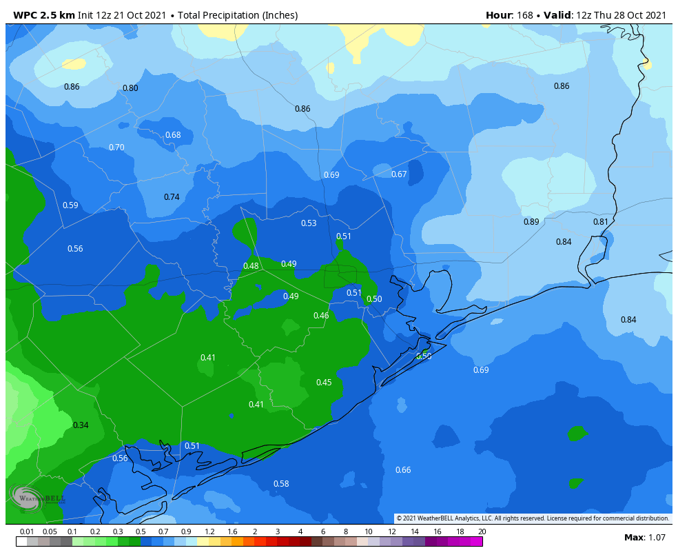
The start of next week will be warm and muggy, and conditions will remain so until a cold front arrives. The timing of all this is not yet set in stone, but the front will likely push through some time on Wednesday. Rain chances will increase ahead of, and along with the front, and this should set the stage for more pleasant weather to end of the month of October.
The Houston area could pick up a few tenths of an inch of rain with next week’s front. (Weather Bell)
Halloween
We are still 10 days away from Halloween, so the forecast is about as solid as a Peeps marshmallow candy. (Incidentally my brother-in-law once found a post Halloween sale on these selling 100 boxes for $1. Such a price would still be too high for me.) Anyway, the effects of the front will probably be fading by Sunday, October 31. My guess for weather on Halloween, then, would be highs somewhere in the low- to mid-80s, and temperatures in the upper 70s around sunset at the trick-or-treating hour. So it could be rather nice, but again, take a 10-day forecast with a grain of salt.
As we near the end of October it’s time to look ahead to the coming winter. While seasonal forecasting is far from perfect, it does have some predictive value. And we know that some people are on edge about winter given the terrible Valentine’s Day freeze the region endured eight months ago. So Matt and I are putting together an extra-long outlook with several parts.
As a special treat, we’re also going to finally answer the question we get asked about a hundred times a year: Do landfalling hurricanes in Houston mean we’re going to see snow during the subsequent winter?
Winter outlook
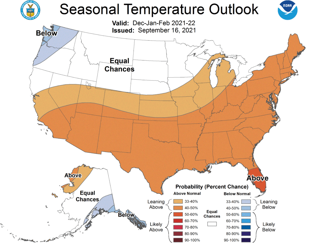
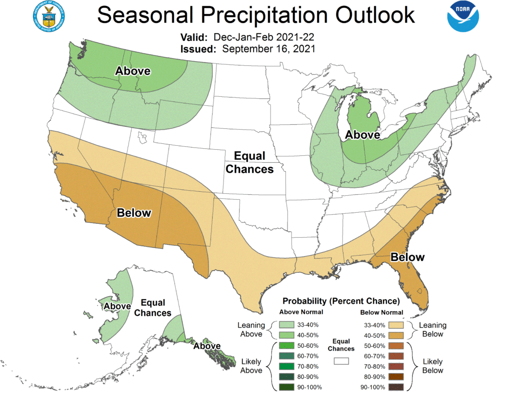
For the purposes of this post, we’re defining winter as the period of December through February. In short: our region of Texas should see somewhat warmer than normal temperatures, and near- or slightly below normal levels of precipitation.
NOAA outlook for temperatures from December through February.
Essentially, the NOAA winter forecast predicts above normal temperatures for most of the United States, and especially southern and eastern parts of the country. In terms of precipitation, we can expect slightly drier than normal weather for the winter months in Houston and much of Texas. It looks like it could be a snowy winter in the Great Lakes region.
NOAA outlook for precipitation from December through February.
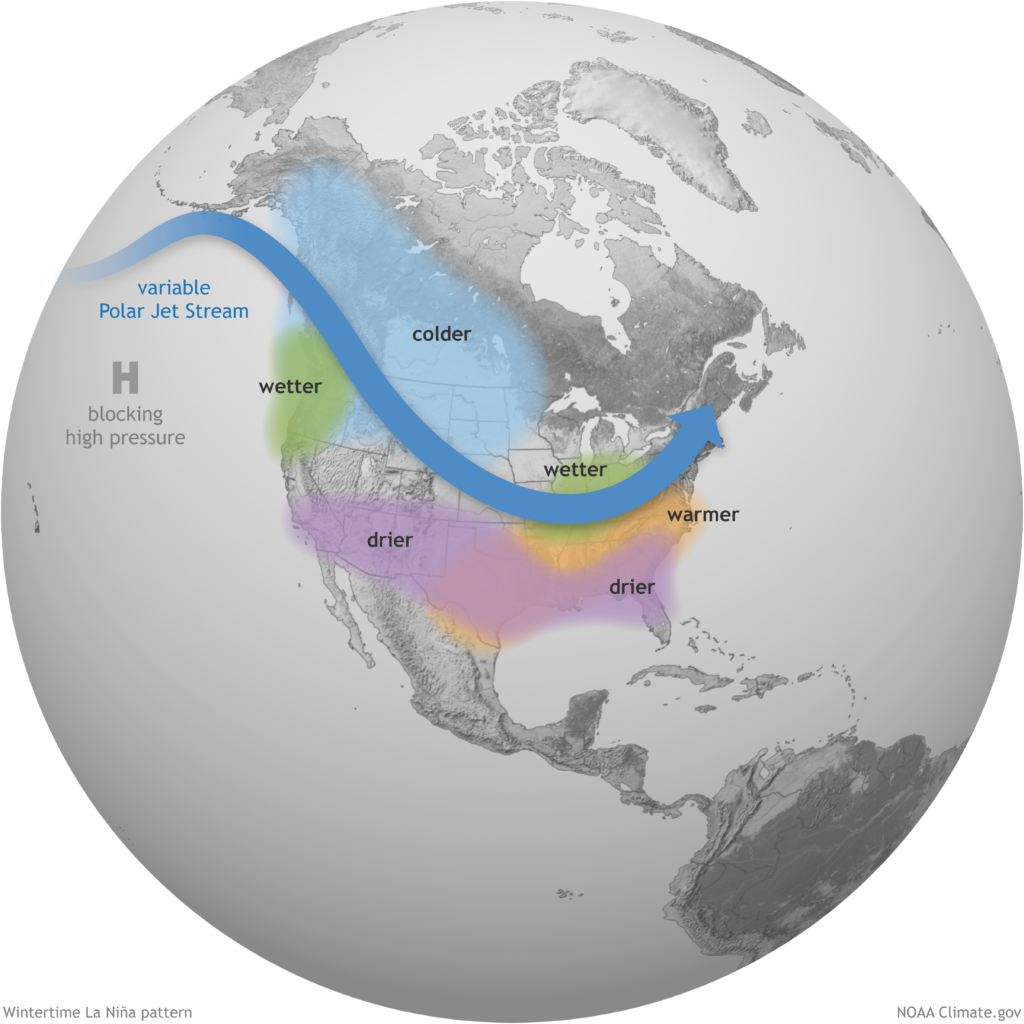
The driving factor behind these predicitons is the expected onset of another La Niña pattern this winter.
What does La Niña mean for this winter?
Forecasters are now confident that a moderate La Niña pattern will develop and persist through the winter of 2021-2022. A La Niña event occurs when sea surface temperatures in the equatorial Pacific Ocean cool below normal levels. This tends to have fairly predictable effects for North America during the winter months.
Assuming a moderate La Niña develops, this typically places the jet stream a bit further north across the United States than normal. This positioning tends to bring fewer storms and fronts into Texas during the winter months, and accordingly we would expect a Texas winter to be warmer and slightly drier than normal.
Wintertime La Niña pattern. (NOAA)
That, of course, is the typical pattern. Sharp-eyed readers may recall that a La Niña pattern was also in place during last winter. So how, exactly, should we feel about that in the context of another super hard freeze this coming winter?
How likely is another February 2021-type freeze?
While nothing is ever certain in life, particularly with respect to weather, the odds of having a similar event to the February freeze in the following winter is very low in Houston. And the odds are no higher than they are in any other given winter. Back just before the cold set in, Matt wrote a post about historic Houston freeze events. The post touched on similar longer-duration cold snaps that occurred in 2018, 2011, 1989, 1983, 1978, 1951, 1940, 1930, 1899, and 1895. None of those occurred in back to back winters.
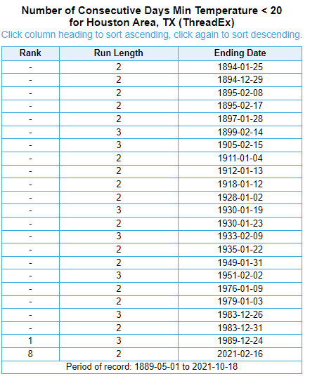
If we want to take a more rigorous statistical approach, we can crunch some more numbers. Back in February we had official low temperatures of 16° and 13° on the 15th and 16th. So let’s look at all winters that saw back to back low temperatures of 19° or colder.
Back to back nights below 20° are uncommon in Houston, and a freeze of that magnitude has not occurred in back to back years since the winters of 1910-11 and 1911-12. (NOAA)
It has not happened in back-to-back winters since January 1911 and January 1912. Prior to that, it also happened in the 1893-94 and 1894-95 winters. Again, nothing is ever certain, but history is more than likely on our side here.
Do summer hurricanes lead to winter snow?
One of the most common winter forecast refrains I’ve heard since moving to Houston in 2012 is that if we have a hurricane in summer, we almost always have snow in the subsequent winter. 2021 saw us get hit with Hurricane Nicholas, so obviously that means we should get ready for an 1895-style snowball fight, right? In words of the great philosopher Lee Corso, “Not so fast my friend.”
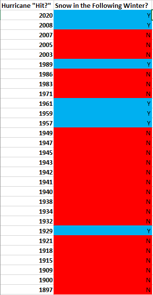
Let’s be somewhat generous and define “hit by a hurricane” as a year in which a hurricane passed within 125 miles of downtown Houston (Editor’s note: Because we are using this strict definition, 2017 was omitted, as Harvey was *not* a hurricane within 125 miles of Houston. It was a tropical storm at that point.) Prior to 2021, 33 hurricanes have met this criteria since 1895. If we match those years up with years that saw snow in Houston (via the old Weather Research Center’s excellent list), we can see what years saw snow after a hurricane hit. So let’s do exactly that. A couple notes about this: First, just because “Houston didn’t see snow,” it doesn’t mean it didn’t snow in some outlying portions of our area. “Houston” sprawls pretty far out, but in order to do this, we need to meet some kind of definition. Second, you may notice a discontinuity between the list of hurricane years and snow years if you try to do this yourself. Just remember that if a hurricane hit in 1983, we had to see snow in the winter of 1983-84 for it to qualify. Incidentally, we didn’t, though we had a pretty memorable freeze that winter. Also, some years saw multiple hurricanes, such as 1989, 1971, and 1934.
Of the 30 summers since 1895 that saw hurricanes pass within 125 miles of Houston, only 7 saw snow in the subsequent winters based on data from the Weather Research Center.
Since 1895, the data (plus 2021) suggests Houston has seen snow in 23 percent of all winters, hurricane or no hurricane. Based on the hurricane data, seven out of 30 winters following a hurricane hit since 1895 have seen snow, placing our odds at—wait for it—23 percent. The takeaway? It’s fun to say that Houston sees snow in winters following a hurricane. The statistics say that is false, and the odds of snow in a post-hurricane winter are perfectly identical to the odds of snow in any other winter.
We’re just the messengers, but please feel free to yell at Matt if and when it snows this winter.