Threepeat: Houston’s third consecutive beautiful weekend is here

For those able to enjoy weekends, congratulations. For the third weekend in a row, we are expecting just stunningly beautiful, chamber of commerce type weather.

Fundraiser

I just want to echo Eric’s sentiment this week, and I want to thank everyone who has been so generous during our annual fundraiser. We sincerely appreciate you, and we are truly humbled by your support. The fundraiser continues for another 18 days, and we’ve got some cool options available here. You can read more from Eric’s post on Tuesday here. Thank you, truly.

Today through Sunday

Temperatures this morning are noticeably cooler than they were 24 hours ago.

This map shows 24 hour temperature change, and we’re running anywhere from 10 to 25 degrees cooler than Thursday morning across the area. (NOAA)

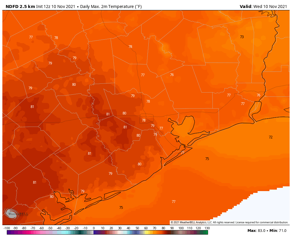
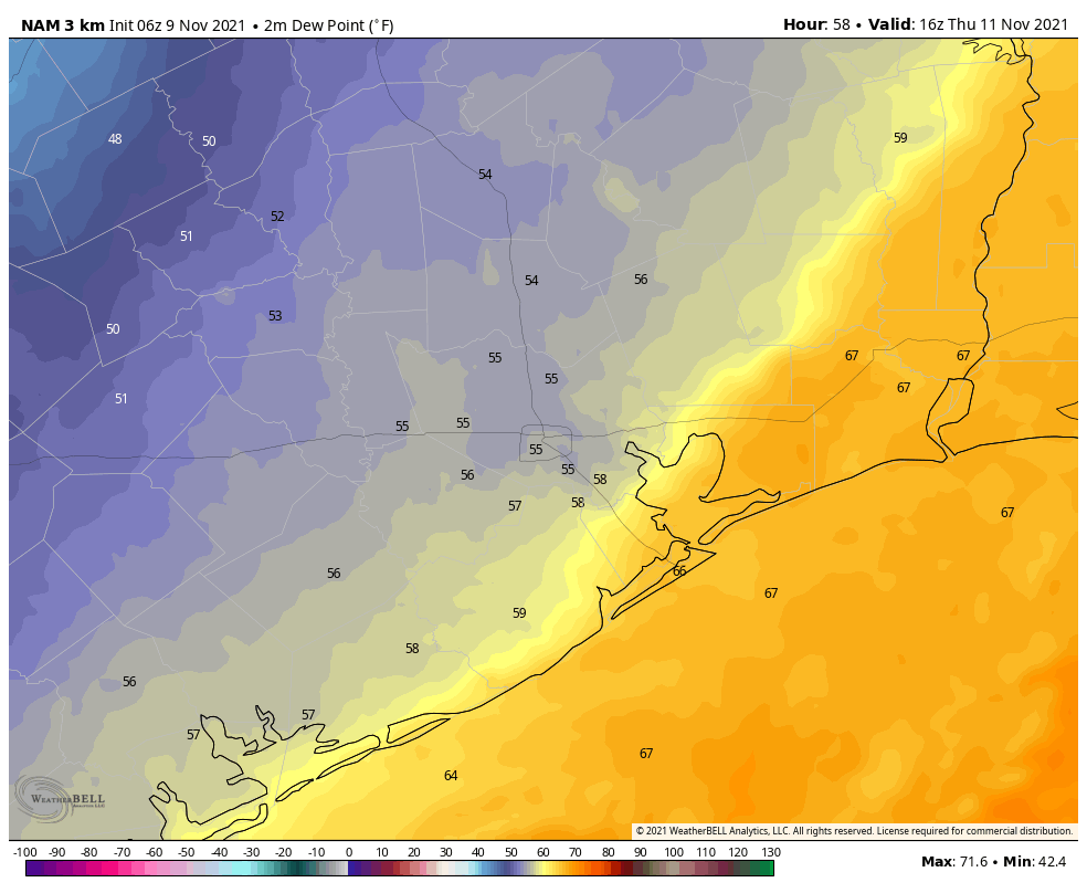
It’s a refreshing start to the day, with 40s and 50s in most spots and 60s along the coast. We’ll see ample sunshine with highs well into the 70s today. We had a cold front yesterday, but it’s still going to be a little warm this afternoon, so what gives? Yesterday’s front was more of a humidity front than a true cold front, so it ushered in drier air for today but the air mass wasn’t really a lot cooler. If you took the temperature about 5,000′ over our heads, which is a good altitude to look at to define the “air mass,” today is only about 3 or 4 degrees cooler than it was yesterday. But it was the dry air that helped allow temperatures to drop more this morning. Now, a secondary front is going to usher in the notably cooler air tonight. That air mass 5,000′ over our heads will drop about 10 to 12 degrees behind that front. This second front will have no moisture to work with, so no rain is expected, but winds may pick up just a bit after it passes and linger into Saturday.

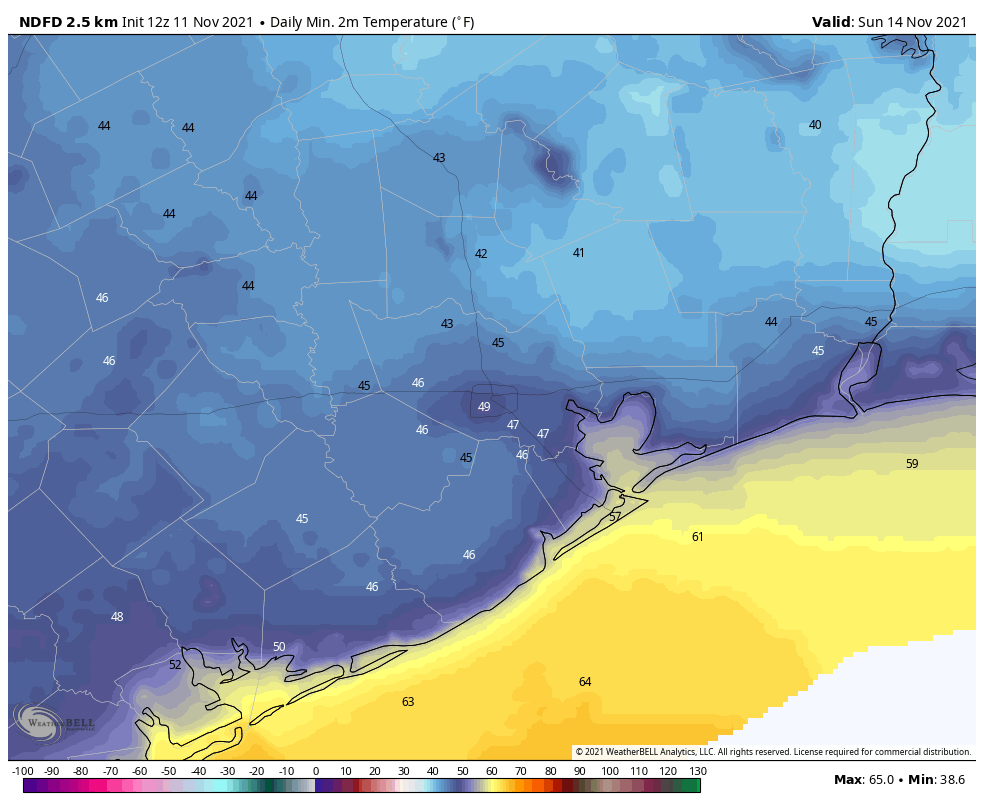
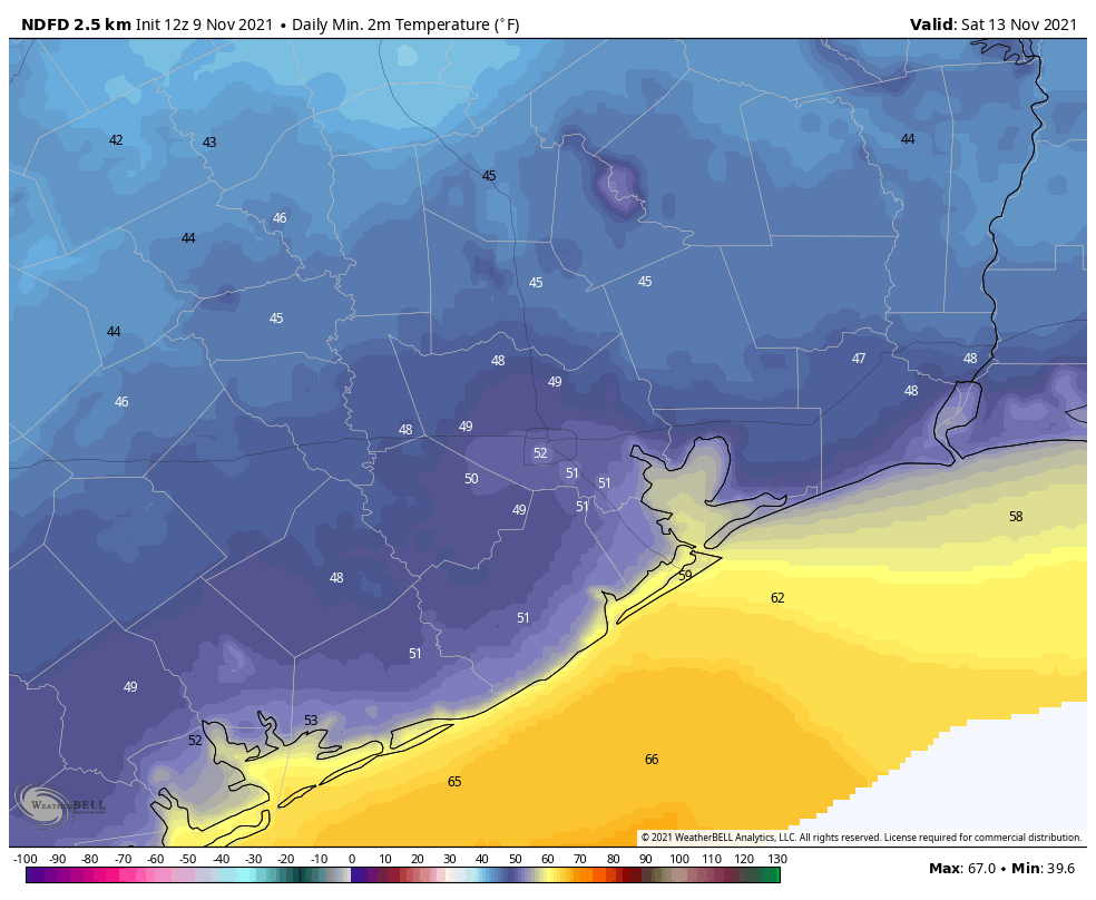
That secondary front will allow temperatures to dip into the 40s tonight across most of the area.

Saturday morning lows should be generally in the 40s in most of the area, with some 50s in the city and at the coast. (Weather Bell)

Saturday should be another beautiful day with full sunshine. Temperatures will be noticeably cooler though, with highs only in the 60s. Look for mostly a rinse and repeat on Sunday, with morning lows in the 40s and a slightly warmer afternoon around 70° or in the low-70s.

Monday

Look for the time honored tradition of onshore flow to resume sometime on Monday. Initially, the day will start cool once again, with 40s or 50s across the region, but we’ll warm into the mid-70s in most spots during the afternoon.

Tuesday and Wednesday

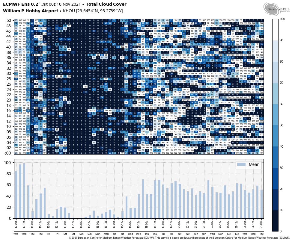
Onshore flow will likely strengthen some here as a fairly tight pressure gradient boosts southerly winds a bit. Tuesday should start in the 50s to near 60, then warm deep into the 70s with sunshine. An 80 degree reading can’t be entirely ruled out in spots on Tuesday afternoon. By Wednesday, look for higher humidity to have fully taken hold with a warm morning (60s) and a rather warm afternoon (80 degrees or better). We should also begin to see a few more clouds by Wednesday.

Beyond Wednesday

The forecast after Wednesday begins to get a little difficult. I think we should see a cold front arrive sometime around Thursday or Friday, but what happens after that front gets through is tough to say. I’m not sure we are going to lock in a fourth consecutive gorgeous weekend, though that’s not an impossibility. But it would appear another front or two could be in the mix heading into Thanksgiving week, with perhaps the strongest one yet just prior to the holiday.

The usual doomsayers have been spreading rumors and such out there on YouTube and Facebook/Meta about “the polar vortex,” among other nonsense. Quite frankly, nothing we’re seeing in the Thanksgiving week timeframe looks that remarkable. As our average temperatures drop and the fronts get a little stronger, perhaps we could see our first official 30s of the season show up sometime Thanksgiving week. It’s far too early to say that will happen with any confidence though. And anything worse than that seems highly unlikely. The average date of our first sub-40 degree temperature in Houston is November 17th, so that would actually be close to normal. We’ll keep you posted.

Storms moving through this morning, with clearing skies soon after

Good morning. A line of thunderstorms is moving through Houston this morning, heralding the passage of a cold front. These storms may bring briefly gusty winds in addition to 0.5 to 1.0 inch of rain to some areas as they cross the region from north to south. Cooler and sunny weather will follow, persisting into early next week.

Thursday

The storms will cross Houston this morning from 6 to 10 am, and afterward we should see fairly rapidly clearing skies. This will allow high temperatures to reach about 80 degrees, but the air will feel somewhat drier. Winds after the front will be out of the north at about 10 mph, with higher gusts. Lows tonight will drop into the mid-50s, with cooler conditions inland, and warmer near the coast. On this Veterans Day, please let me express our appreciation for all who have served, and do serve our country.

Houston radar reflectivity at 6:37 am CT on Thursday. (RadarScope)

Friday

This will be a sunny, fine day with high temperatures in the upper 70s. A reinforcing cold front will follow on Friday afternoon (there will be no rain with this one, due to the drier air), and this will set the stage for a chillier start to the weekend as lows fall to around 50 degrees in Houston, with 40s for inland areas.

Saturday

This will be the coolest day of the forecast period, with highs likely only in the upper 60s, even with sunny skies. Winds will be moderate, out of the north at 5 to 10 mph. Saturday night will be clear and cold, with temperatures possibly dropping into the upper 40s in Houston itself and all the way to the coast.

Sunday morning should be the coolest of the week. (Weather Bell)

Sunday

Another sunny day, and despite the chilly start highs should work themselves into the mid-70s. Lows Sunday night will be a few degrees warmer than Saturday night as well.

Next week

As a southeasterly flow returns, we’ll see a warming trend next week, and by Wednesday or so temperatures could pop back up above 80 degrees. For a day or two, things could get fairly warm and muggy for November, but another front is likely to move through by Thursday or Friday. Some readers have asked about a forecast for Thanksgiving, and I’d love to oblige. But we’re still 14 days away and there’s no strong signal in the models, so there’s just not much sensible to say right now.

2021 Fundraiser

We’re in the middle of our annual three-week fundraiser, and any merchandise you purchase, or donations you make, will sure help us next year. Thank you so much.

Warm today, with storms possible Thursday morning along with the next front

Good morning. Matt and I just wanted to thank everyone who generously supported the site as we kicked off our annual fundraiser Tuesday. The response so far has been tremendous. If you want to help, we’re selling plenty of Space City Weather merch, and also accepting donations. Read more about it here.

Overall our forecast remains on track. Houston will have one more somewhat warm and muggy day before a front moves into the region on Thursday morning, setting the stage for sunny, clear, and cool weather through early next week. Some storms may accompany Thursday morning’s front.

Wednesday

Skies are mostly cloudy this morning across the region, with patchy fog. Despite the lack of much sunshine, highs today are going up to about 80 degrees. Winds will be out of the south at about 10 mph, with gusts possibly up to about 20 mph. Some brief, light showers are possible today and tonight, but accumulations, if any, will be slight. Most of us will just see gray skies. Lows tonight will not drop much below 70 degrees for most of the area.

Parts of Houston will, briefly, get back to 80 degrees today. (Weather Bell)

Thursday

Some forecast models are now indicating the potential for at least a broken line of showers and thunderstorms to move into Houston ahead of a cold front on Thursday morning. If you’re planning to attend a Veteran’s Day ceremony on Thursday morning shortly after sunrise, this will be something to have in the back of your mind. Generally, this system should move through the region from northwest to southeast, somewhere in the time frame of 4 am to 10 am CT. A few areas may see a quick inch or two or rain, whereas the majority of the region will probably see one quarter of inch of rain, or less.

Dewpoints will begin falling in the wake of the front, and we should see at least partly sunny skies by Thursday afternoon with highs in the 70s. Lows Thursday night will drop into the 50s. Winds will be out of the north, but we’re not expecting anything too gusty.

Friday

Expect highs in the mid-70s with lots of sunshine and drier air. A reinforcing shot of colder air will arrive Friday night, and this will set the stage for a cooler start to the weekend. Lows Friday night will probably drop to around 50 degrees in Houston, with cooler conditions in outlying areas.

Houston should see a solid block of sunshine from Friday through Monday. (Weather Bell)

Saturday and Sunday

Despite sunny skies, highs may struggle to reach 70 degrees on Saturday, and Saturday night could bring lows in the upper 40s in Houston. Sunday will be a few degrees warmer, with more sunshine. Plan your weekend activities with confidence.

Next week

Most of next week should see highs in the mid- to upper-70s, with partly sunny skies. Another front appears likely to move through toward the end of next week, perhaps around Friday, November 19. But, my friends, our confidence in that is about as firm as tissue paper.

We’re launching our 2021 fundraiser today—your chance to give back

Space City Weather is free, and always will be. But it costs money to produce and publish this website, and Matt and I put a lot of time and effort into our product. Today, with the opening of our 2021 fundraiser, comes your chance to give back. Your purchases and donations during the next three weeks will support the site next year, allow further upgrades to our app, and more. It’s also a nice way to thank us for our efforts following a wild weather year that included a historic freeze and Hurricane Nicholas.

This year we are selling t-shirts and sweatshirts with two different designs, an umbrella, an insulated tumbler that people loved last year; and new for this year, a baseball hat. You may order any of these items by clicking on the links below, or visiting the entire collection here. All items should arrive a week before Christmas. You may also simply donate money by clicking any of the links, and selecting “donate only.”

Thank you for your support—Matt and I are always truly humbled by the response to this fundraiser.

Tuesday

Conditions are cool this morning, but we’re already seeing the return of some clouds that herald the coming of somewhat more humid air, and warmer nights. With light southeasterly winds, we’ll see partly to mostly cloudy skies for the remainder of Tuesday, with highs pushing into the mid- to upper-70s. Rain chances are near zero. Overnight lows will drop to around 60 degrees in Houston, with cooler conditions inland, and warmer ones near the coast.

Wednesday

This will be another day with a mix of sunshine and clouds, but with rising atmospheric moisture levels there will be a slight chance of light rain, perhaps about 20 percent for Houston. Winds will also be more prominent on Wednesday, likely gusting to 20 mph or higher from the south. Expect highs to top out somewhere from 75 to 80 degrees. This will be the warmest night of the week, with lows only dropping into the mid- to upper-60s for most.

The NAM model is fairly quick with the front’s timing, bringing it to the coast by around 10 am CT on Thursday. (Weather Bell)

Thursday

A cold front remains on track for Thursday, and it now looks likely to reach the city of Houston by or before noon, and pushing off the coast shortly afterward. There appears to be no line of storms with the front, and if you do see rain accumulations will probably be less than a quarter of an inch. After the front moves through we should see clearing skies and falling dewpoints. So while afternoon highs will reach the upper 70s, it should feel much drier out. Overnight lows should drop into the 50s for all but the coast.

Friday, Saturday, and Sunday

The weekend looks clear and cool, with highs generally ranging from the upper 60s to mid-70s. Lows should drop into the 40s for inland areas, about 50 degrees in central Houston, and a bit warmer along the coast. Saturday should be the coolest day. Enjoy the fall weather, y’all!

Saturday morning low temperatures. (Weather Bell)

Next week

Highs next week should recover to the upper 70s, but there’s not yet a clear picture on when our next front comes through—Wednesday? Friday? It’s too early to have any confidence.