This morning is pleasantly chilly for early December, with temperatures in the 50s across the area. However winds today will gradually become easterly, and this will set us upon a pretty dramatic warming trend later this week, culminating in the mid-80s by Friday. A strong front will arrive late on Friday night or Saturday morning, and reset our thermometers back to more winter-like weather.
Tuesday
Despite the chill in the air, temperatures this morning are still about 10 degrees above normal for this time of year, when we should be in the mid-40s. With skies remaining partly cloudy today, expect highs to top out in the mid-60s, with light winds turning easterly. Lows tonight will drop into the 50s tonight for all but coastal areas, which will be a bit warmer.
Wednesday
Some fog will be possible Wednesday morning as dewpoints match temperatures before sunrise. The day itself should be mild for December, with highs in the mid-70s. With mostly southeasterly winds we’ll start to see humidity levels recovering. Overnight lows Wednesday will drop into the 60s, with only far inland areas potentially dropping into the 50s.
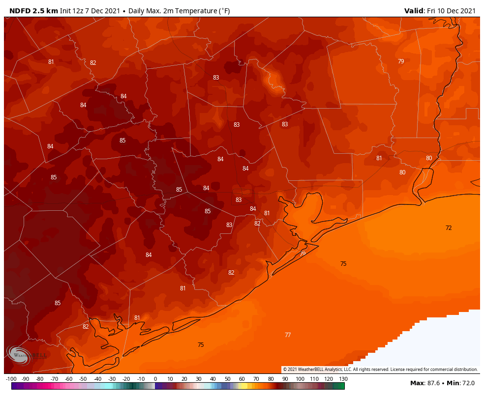
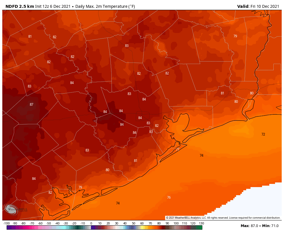
Looks like we’re celebrating fry-an-egg Friday this week. (Weather Bell)
Thursday and Friday
These will be warm and fairly muggy days for December, with highs in the low- to mid-80s and a mix of clouds and sunshine. Some isolated to scattered showers will be possible both days, but I’d peg rain chances at less than 20 percent. Rain chances increase Friday night as a front approaches the region, but for now I think this activity will not pick up until after midnight.
Saturday and Sunday
The weekend should be clear and cold once the front passes. So when will that be? Right now the models show the front arriving in Houston by around sunrise on Saturday morning, if not a bit before. It looks like a few tenths of an inch of rain may accompany the front, but we’re not looking at anything too intense, or too long lasting. This should be a pretty clean frontal passage, with the moisture being swept out in its wake. As a result we probably will see clearing skies by late morning or early afternoon.
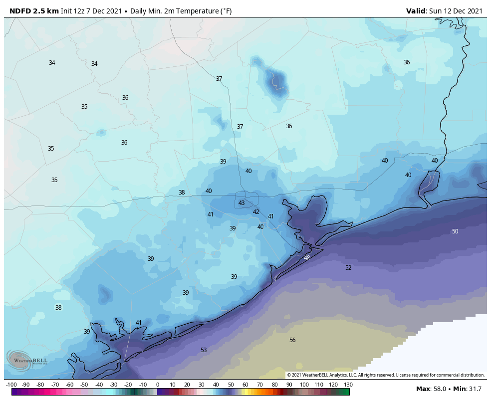
Temperatures will make a quick fall in the wake of the front, reaching their nadir on Sunday morning. (Weather Bell)
By Saturday afternoon temperatures will likely fall to around 60 degrees, and keep going down from there. It will feel chilly, especially with northerly winds gusting to 25 mph or higher. Right now these gusts should begin to die down during the evening hours, which is good because temperatures will be dropping into the 40s by late evening, and to around 40 degrees by Sunday morning. Inland areas outside of Houston’s urban core will likely see lows in the 30s, although temperatures most likely will remain above freezing. Despite ample sunshine, highs on Sunday will peak at about 60 degrees. It will be a fine winter day in Houston. Overnight temperatures will again get down into the low 40s in Houston.
Next week
By Monday a warming trend begins, but I don’t think we’re going back into the 80s. Mostly, next week, we should be in the 70s. So, not winter-like. But not exactly October weather, either.
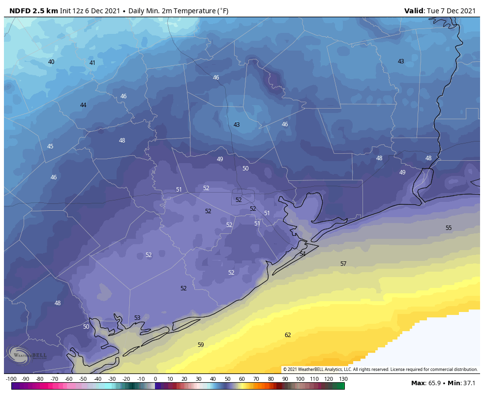
Good morning. A cold front is moving toward the region, and will reach central Houston by around noon, pushing off the coast later this afternoon. I’m not anticipating anything too explosive, but some showers and thunderstorms are possible with the front’s passage. We will see a brief cooldown through Wednesday before we warm up again for the second half of the week. A cold front on Saturday should bring us a more sustained stretch of cooler weather—finally allowing things to feel like winter again out there.
Also, before jumping into the forecast, several readers asked about a string of bright lights in the sky over Houston on Friday evening, at about 6:10 pm CT. I’m sharing a photo from a reader, Dave, below. The passage across the sky took about 1 minute. This was a “train” of Starlink satellites, which are launched in batches of 48 to 60 by SpaceX. The company now has a growing constellation of about 1,700 satellites to provide internet broadband service. The Starlink megaconstellation in low-Earth orbit is celebrated because it will bring high-speed internet to areas without it, but also criticized because orbit-raising trains such as this one impair the ability of astronomers to study the night sky. There are also concerns about orbital debris due to collisions as SpaceX, OneWeb, Amazon, and others assemble such constellations.
Train of Starlink satellites over Houston on Friday evening. (dave t)
Monday
High atmospheric moisture levels are allowing showers to develop south of Interstate 10 this morning, and more scattered showers and thunderstorms are possible. Rain chances will increase as a cold front passes through the area, likely around 10 am for Conroe and The Woodlands, noon for Houston, and afternoon for coastal areas. A line of showers and thunderstorms will accompany the front as it passes through. Most areas will probably see 0.5 inch of rain or less, but a few areas could pick up 1 inch or more. Rains should end pretty quickly after the frontal passage.
After a decidedly humid weekend, temperatures and dewpoints will fall this afternoon, with northerly winds and much drier air. Lows tonight will probably drop to about 50 degrees in Houston, with cooler conditions inland.
Tuesday morning will bring a splash of cold air into the region. (Weather Bell)
Tuesday
Tuesday’s temperatures will depend upon how quickly the clouds clear, but I expect partly to mostly sunny skies by the afternoon hours, with highs in the mid- to upper-60s. With the return of the onshore flow, Tuesday night will probably be 5 to 10 degrees warmer than Monday night.
Wednesday, Thursday, and Friday
A southerly flow really picks back up during the second half of the week, and this will pop temperatures back up into the low 80s by Thursday and Friday. Nights will be correspondingly warm, perhaps not falling below 70 degrees in parts of Houston. Skies will see a mix of sunshine and clouds, with rain chances probably below 10 percent.
Friday could be particularly warm for Houston. (Weather Bell)
Saturday and Sunday
A stronger cold front should arrive on Saturday, probably before noon, to end our fling with warm December weather. Some showers and thunderstorms may accompany this front as well, but at this point I think we’ll see clearing skies by Saturday afternoon, with chilly air moving in overnight, and lows dropping into the 40s. Sunday may only bring highs near 60 degrees, with mostly sunny skies, before a chilly night again. A slow warming trend likely begins Monday.
Hobby Airport has started December with back to back 80 degree days, and there could be more to come. The last time we did back to back 80s in December was in 2019. We also accomplished the feat in 2016, 2015, 2013, and 2012, so it’s not super abnormal. Whatever the case, this is quite a departure from when I last wrote in this space a week ago and we had multiple European model ensemble members depicting 30s for lows in Houston this weekend. You can forget that. Let’s talk about what we can expect.
Today
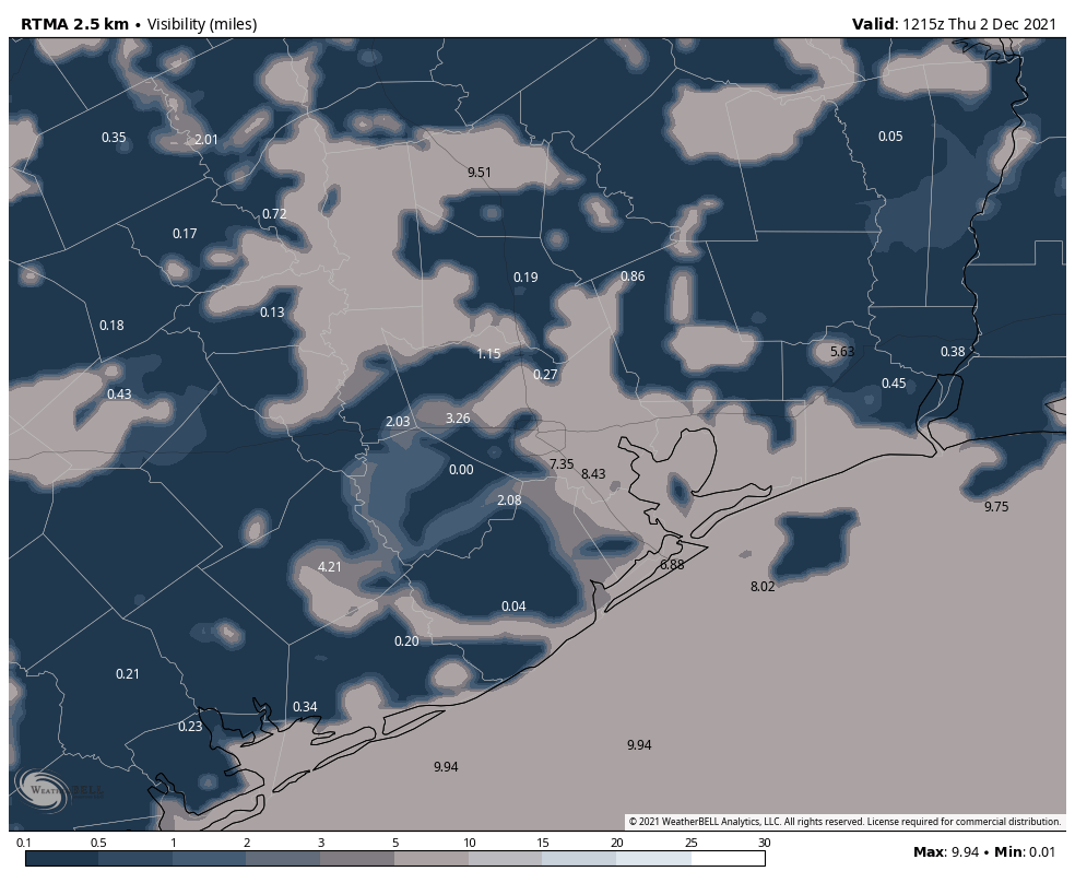
Look for more fog this morning that should again lift by mid-morning in most spots. Dense Fog Advisories are posted around the region, but the fog is a bit spotty. It appears Brazoria County has some dense, as may parts of Montgomery County. The Beaumont/Port Arthur area is also seeing dense fog. Everyone else seems to be fine or seeing lighter fog. But you may run into some patches of dense fog as you maneuver around the area this morning.
Most areas are seeing restricted visibility this morning, but dense fog is a bit spotty, mainly south or east of Houston. (NOAA)
Once the fog lifts, we will be left with a mix of clouds and sun this afternoon, as highs again make a run for 80 degrees. One of the differences between yesterday and today is that we could see a couple sprinkles or showers as a weak disturbance passes by. It may be enough to wet the ground in a few spots, but that’s about all.
Weekend
Saturday will see any morning fog lift once again, leading to a partly to mostly sunny day. A few showers can’t be ruled out Saturday afternoon, but those would be the exception, not the rule. Look for highs in the upper-70s to around 80 degrees after a warm morning in the mid-60s.
Look for mostly the same on Sunday, except it may be more like partly to mostly cloudy. Again, a slight chance of showers will exist, but nothing you need to change plans for I don’t think. Another morning in the mid-60s or warmer will transition to an afternoon in the upper-70s to 80 degrees or so.
Monday
Here’s where some intrigue begins. A cold front should actually press through the region early in the day. We will probably start the day well into the 60s in most spots, and then when the front passes through we will see temps hold or drop a bit. So 80 degrees probably isn’t in the cards for Monday.
Instead, expect a period of morning showers and storms, then cooler, breezy weather in the afternoon. Temperatures should drop into the 50s on Monday night.
Forecast lows for Monday night and Tuesday morning show something more autumn-like, at least for a day, with 50s and a few scattered 40s around. (Weather Bell)
Tuesday and beyond
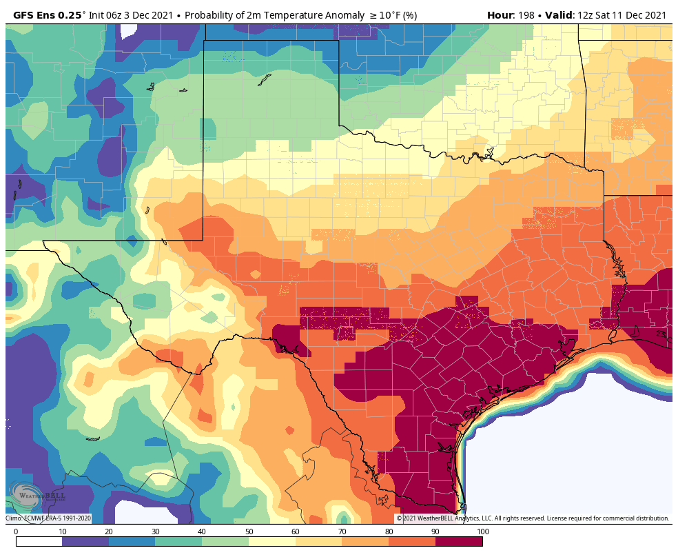
Offshore winds are going to flip around and become onshore winds quickly late Monday night and Tuesday, leading to a substantial increase in moisture. Beyond that, we could be entering a bit of an active period of weather with showers, storms, and even some strong storms in the area ahead of another cold front. This would be most likely later Tuesday or Wednesday. Cooler air would settle in late next week but probably again for only a couple days. By next Saturday, the GFS Ensemble mean already has an over 90% chance that temperature anomalies will be at least 10 degrees warmer than normal.
If we look at multiple GFS Ensemble members, 90 percent of them, or more, say that temperatures will rebound back to at least 10 degrees warmer than usual next Saturday. (Weather Bell)
This means that of the 30+ GFS ensemble members, almost all of them see much above normal temperatures again next weekend.
The Arctic Oscillation
I’m going to take you more under the hood about things right now. Meteorologists use numerous tools to make forecasts. One of those tools is called “teleconnections.” We don’t often talk about those here in an effort not to bore you, but I think it’s instructive today and can explain some of why December looks to be so much different than how autumn has been for the last month or so.
Teleconnections are ways of explaining that because one thing happened in one place, there’s more predictability that something else could happen in another place. In other words, if you have a certain pattern over Alaska, that can often teleconnect to a certain pattern downstream over the continental United States. There are numerous teleconnections we can use, but one of the most useful ones is called the “Arctic Oscillation,” or AO. You can read more about the AO here if you’d like. The simplest explanation? As the AO trends more positive, this indicates a stronger polar vortex, one that’s more likely to stay near the North Pole where it belongs. We typically lean milder in those scenarios with most cold remaining in the high latitudes. If the AO flips significantly negative it can mean the polar vortex has weakened and is more likely to allow chunks of cold to travel south toward the mid-latitudes where more people live. For example, just ahead of the massive February freeze last winter, the AO got as low as -5, which was one of the most negative values of this index recorded since 1950. That did not cause us to get super cold here in Texas, but you bet it helped explain why.
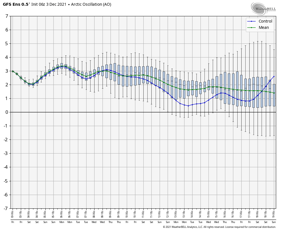
So, why am I telling you about this? Well, if you look at a forecast of the AO Index for the next 2 weeks, what stands out?
The Arctic Oscillation is forecast to remain sustained positive the next 2 weeks, which should help skew the odds toward warmer than normal weather here most of the time. (Weather Bell)
It’s raging positive (green line). We are frequently forecast to be at or above +2, with some ensemble members getting as strong as +4 to +5 at times. While this doesn’t guarantee that we’re going to stay warm deep into December, it sure skews the odds that way. No single teleconnection is a magic bullet in meteorology, but they serve as pieces to a larger, complex puzzle we try to solve each day. Today, this one stands out as one that will have an outsized influence on our December weather, so I thought it would be a good time to explain this to you. Hopefully it’s insightful! Enjoy the weekend.
Although we’re in the month of December, you wouldn’t know it from the weather. It’s not that we are going to exactly be hot—rather conditions will remain quite mild—but it’s definitely not going to approach cold weather, even “Houston” cold. The bottom line is that if you’re like Goldilocks, and like things not too hot or not too cold, you’re in luck for at least the next week or 10 days.
Some parts of the region have visibilities of less than one-quarter mile this morning. Take care. (Weather Bell)
Thursday
Dense fog is back across parts of Houston this morning, and a National Weather Service advisory remains in effect until 9 am. After the fog dissipates we should be left partly sunny skies and high temperatures near 80 degrees. The calm winds this morning, which are aiding in the development of fog, should become southerly at 5 to 10 mph this afternoon. Overnight low temperatures will be about five degrees warmer tonight, only dropping into the lower 60s in Houston, with inland areas possibly seeing the upper 50s.
Friday
We’ll likely see the development of more fog on Friday morning. This should be a partly to mostly cloudy day afterward as an atmospheric disturbance passes overhead, but overall rain chances will remain fairly low, probably about 10 percent or so as other factors will mitigate against the development of showers. Highs will likely top out in the upper 70s with another night in the low 60s.
Saturday and Sunday
The weekend continues our trend of mild weather, with highs of around 80 degrees and lows in the lower 60s. Skies on Saturday should be mostly sunny, and although we’ll probably see more clouds on Sunday I think rain chances will remain near zero during the day time. There’s modest chance of light rain Sunday night as a front nears the region.
This is what I mean by mild for as far as the eye can see. (Weather Bell)
Next week
The aforementioned front should push into Houston on Monday, probably during the overnight hours but that’s not locked in. This will set the stage for slightly cooler weather for a day or two, with highs on Monday topping out at around 70 degrees, and overnight lows in the 50s. We warm back up before another front (probably) comes through on Wednesday. This one may bring a little rain with it, but beyond that the details are fuzzy. This one probably won’t have too much oomph either, so lows in the 50s seems like a good bet right now.