Heavy rain possible on Monday, with an Arctic front arriving Wednesday night

Good morning! There is a lot of weather to talk about for this week, but first I want to say a word regarding our app, which is available for Apple and Android devices. Several readers have written to note a bug in the 7-day forecasts on the home screen, and we’re aware of it. Fixing this will be part of our next update, which will also include some of your most requested features. We’ll have more to say on this soon, but I did want to take a moment to apologize for the bug.

With that said, let’s talk about today’s rains and an Arctic front coming into Houston later this week.

Monday

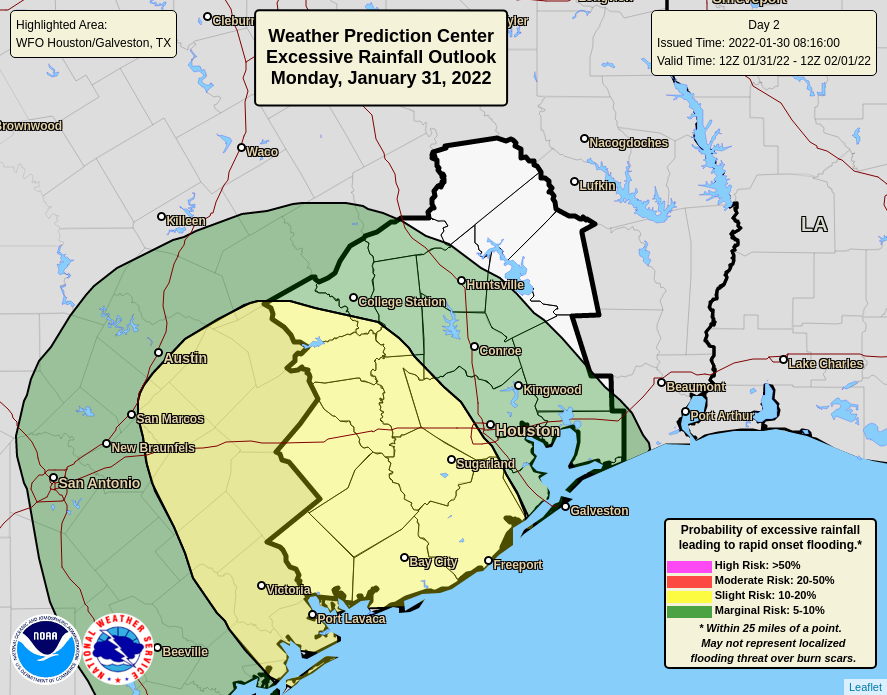
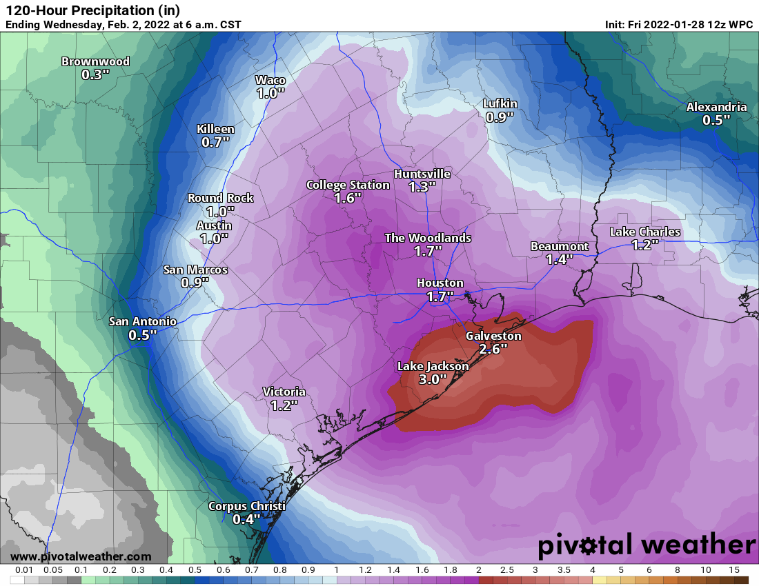
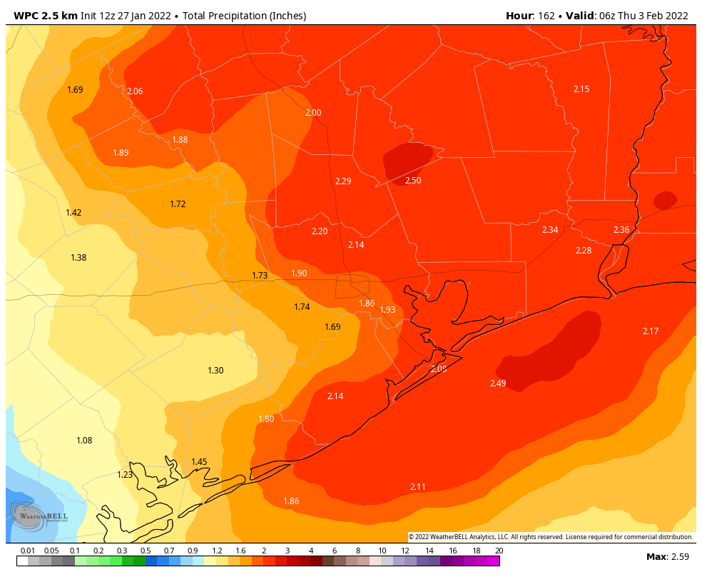
The high pressure system that brought our beautiful weather this weekend has now exited eastward, and in its place a low pressure system will move into the region today. Light showers will develop to the southwest of Houston this morning, and move into the city later this morning. The potential for heavy rainfall is greatest this afternoon and evening, before activity winds down around midnight. Generally I think the region will see 2 to 4 inches for areas west of Interstate 45, and 1 to 3 inches east.

NOAA rain accumulation forecast for now through Monday night. Some areas will see higher totals. (Weather Bell)

The greatest threat for heavy rainfall is likely near Matagorda Bay, and areas southwest of Houston, where higher isolated totals of 6 inches or more are possible. Due to the threat of some street flooding, we have instituted a Stage 1 flood alert for today and this evening. Note that these impacts are most likely during the evening commute. Highs, otherwise, will reach the mid- to upper-60s today, with lows in the upper 50s Monday night.

Tuesday

Congratulations. This is the one day with zero weather concerns this week. Expect highs in the low 70s with mostly cloudy skies. We may briefly see a little sunshine during the afternoon hours. Winds will be light. Overnight lows will again drop into the upper 50s.

Wednesday

This will be another warm-ish day, with highs likely reaching the mid-70s beneath cloudy skies. Some light showers will be possible during the afternoon hours, ahead of a front that will sweep through on Wednesday night, reaching Houston between midnight and sunrise on Thursday, and pushing off the coast by sunrise. Temperatures will drop sharply with this front, but most likely any rainfall accompanying it will end before temperatures get cold enough for wintry precipitation.

Thursday

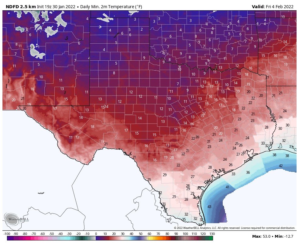
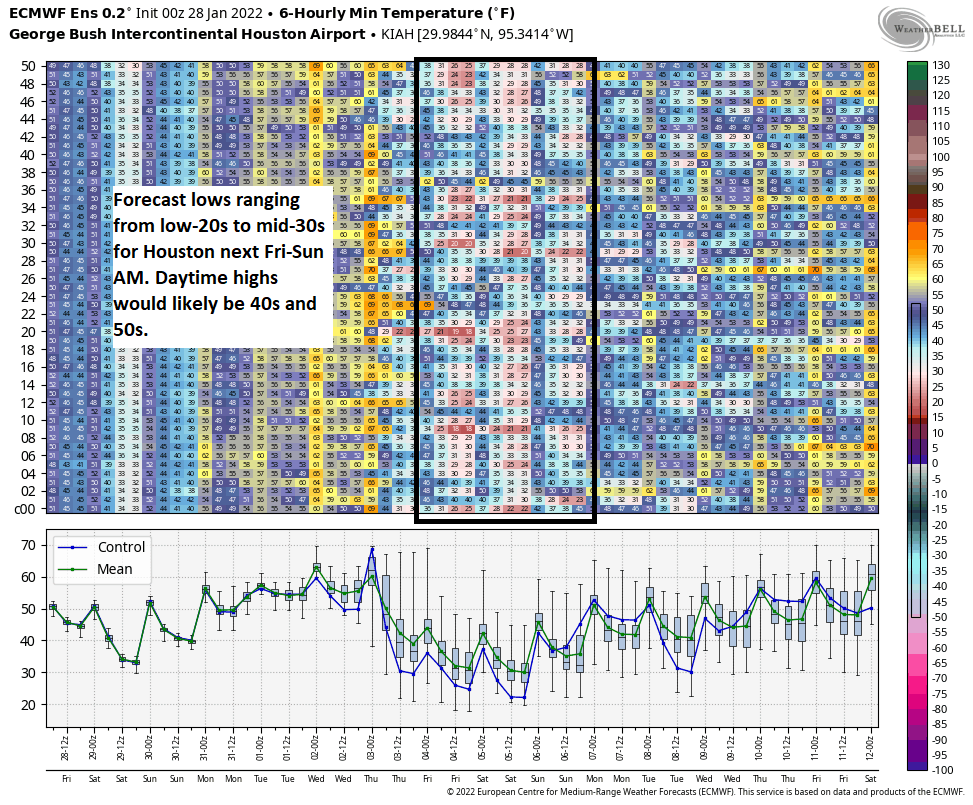
Welcome to winter. Skies will be mostly cloudy on Thursday, with rains likely ending by or before noon. Your afternoon temperatures should top out at about 40 degrees, made to feel colder still by a stiff northerly breeze. The question becomes how cold it will get on Thursday night, and that is going to depend on whether skies clear somewhat (which would make things colder), and how quickly winds die down (more winds means more mixing, which would trend warmer). For now I think we’ll see mid-20s for inland areas such as Katy and The Woodlands, upper-20s for central Houston, and a light freeze right along the coast. This should be just warm enough to preclude concerns about widespread pipe damage, but the forecast at this point could still go a bit warmer or a bit colder.

Current forecast for low temperatures on Friday morning. (Weather Bell)

Friday

Friday will be cold, with partly sunny skies, and highs in the low 40s. Expect another cold night with temperatures perhaps a degree or two warmer than Thursday night.

Saturday and Sunday

The weekend looks partly sunny and chilly. Expect highs of around 50 degrees on Saturday, with a light freeze possible Saturday night, and in the mid-50s on Sunday. We can’t rule out some light rain each day, but for now I’d bet on dry conditions. A slow warming trend should continue into next week.

We’re issuing a Stage 1 flood alert for Monday, and tracking a hard freeze later this week

It is such a lovely day across the Houston region today it’s difficult to imagine unpleasant weather. But we’ve got plenty of that on tap for the week ahead, so we’re jumping in with a Sunday post to keep you in the loop.

Monday’s rains

We continue to expect that a low-pressure system will produce widespread rainfall across the Houston region on Monday, generally from the late-morning hours through around midnight. Rainfall amounts are going to vary widely with this system, as some areas pick up less than one-half inch of rain, and other locations 2 to 4 inches, if not a bit more. Because these rains have the potential to produce some nuisance street flooding, we think it’s worth instituting a Stage 1 Flood Alert. This will primarily affect areas south of Interstate 10, and west of Interstate 45.

Generally, the closer to the coast you live, and the further west of Houston, the more likely you are to see heavy rainfall. The good news is that we don’t anticipate any severe weather beyond heavy rainfall on Monday, so tornadoes or strong winds are unlikely. These rains should end over night with partly sunny skies on Tuesday.

Locations for excessive rainfall on Monday. (NOAA)

Mid-week freeze

The next event on our radar—if you thought I was going to spare you weather puns because of the Sabbath, you thought wrong—is a cold front that will arrive on Wednesday night. Some additional rain showers may well accompany this front, but I think our atmosphere will dry out before the coldest air arrives. This should preclude any wintry precipitation for the Houston metro area, but I’m not ready to entirely rule that out yet.

The bigger story will be colder air, with low temperatures likely dropping into the 20s for Houston on Thursday and Friday nights. Even Galveston Island may see a light freeze on Thursday night. These temperatures should be about 10 degrees warmer than the region experienced during the freeze last February, but it will nonetheless be quite cold. As we get closer, we’ll be able to fine tune the temperature forecast.

Current forecast low temperatures for Friday morning. (Weather Bell)

Still more significant impacts are likely for inland parts of the state this week, particularly the Dallas area. Beginning late Wednesday afternoon through Thursday, snow and ice are likely for the Metroplex. Low temperatures on Thursday night probably will get into the teens. So if your plans take you north of Houston this week, roads and more could be mess.

If you’re wondering what this means for the Texas power grid, the answer is I don’t know. We’re not going to see the cold extremes we saw in 2021, but it will still be plenty cold across the entire state.

More tomorrow.

A quiet weekend awaits Houston before busier weather arrives next week

So, if you were looking for a nice weekend, you will get your wish. The weather this weekend looks great: Sunshine, comfortable afternoons, and not too much wind. We will enter a more active weather pattern next week with a number of things to talk about, none super serious but a few you will want to be mindful of moving ahead.

Today

We have a weak cold front sneaking through this morning, which has led to some showers, primarily south of Houston, toward Wharton and Matagorda Counties. So you may get some showers down there. The rest of us will see clouds slowly clear out this morning, leading to a sunny afternoon. It will feel a little cooler today with generally mid-50s and a breeze.

Saturday & Sunday

As noted above, both days look great with sunshine and just a few clouds. We’ll warm from the 30s to around 60 degrees on Saturday, and then we’ll go from 40 or so into the mid-60s on Sunday. Just splendid.

Monday

The first hurdle for next week comes on Monday. Modeling has been in pretty good agreement on a rather vigorous little disturbance swinging through the region with a period of rain for a good chunk of the area beginning in the mid to late morning and ending sometime Monday evening. I will definitely mention the chance of thunderstorms here as well. At this point, widespread severe weather isn’t expected with this disturbance, but I think we should watch Monday for at least the chance of a few stronger storms especially south of Houston. We’ll update you Monday morning with the latest.

Rain totals could be as high as 2 to 3 inches with Monday’s disturbance. Confidence in totals is highest south of Houston, whereas north of Houston, there is still a bit of uncertainty as to whether we’ll see quite as much rain as advertised. (Pivotal Weather)

On average, I’d expect an inch or so on Monday, particularly from I-10 southward. There will likely be areas of higher amounts up to 3 inches or so, again especially to the south of Houston. Areas north of Houston may see a bit less, depending on the exact track this disturbance takes.

Outside of Monday’s rain, it will be a touch milder with morning lows around 50 or in the 50s and daytime highs in the 60s.

Tuesday & Wednesday

Behind Monday’s storm, we should calm down on Tuesday and most of Wednesday. Look for clouds, some sun, and perhaps a shower chance. We have a shot at 70 degrees on both days, and depending on the exact timing of the next front, it could push well into the 70s on Wednesday. Morning lows will generally be in the 50s. As warm, humid air starts to return, expect the Gulf fog machine to try and turn back on for the first time in awhile, so we could have some gloomy mornings with low visibility.

Late next week

Our next front is timed out to late Wednesday night or Thursday morning. Expect showers and thunderstorms as this pushes through, with another widespread rainfall possible. As Eric has noted, the air behind this front is going to pack a little punch. Expect windy and colder conditions Thursday and a decent chance at a freeze on both Friday and Saturday morning and possibly Sunday morning as well. It’s a little too early to get too specific, but at the very least, I think we should be expecting a freeze similar to what we’ve already seen this winter, with risk for temps a couple degrees colder than that.

Within the 51 European ensemble members, there is a spread of low temperatures ranging from the low-20s to mid-30s. Our current expectation would be for mid to upper-20s in Houston on Friday, Saturday, and possibly Sunday morning, but that range indicates there is still some uncertainty. (Weather Bell)

If you look at the various ensemble model guidance, there is a range of morning lows from the low-20s to mid-30s next weekend, meaning there’s still a lot of uncertainty here on specifics. But I think it’s safe to plan on mid to upper-20s for a few mornings for now, and we’ll adjust up or down next week as needed. The good news is that daytime highs look to be generally in the 40s, if not low-50s, so we will warm well above freezing each day. We will keep you posted on this, but just to be clear, while cold, this doesn’t appear to be a repeat of last February.

Houston will see lots of sunshine and cooler air, before a warmer and wetter pattern early next week

Good morning. Houston will see lots of sunshine and cooler weather over the next four days before some clouds, warmer air, and pretty healthy rain chances move into the picture early next week. After a few warmer, wetter days it appears likely that a strong cold front will arrive on Wednesday to bring us very much back into winter-like conditions. A freeze seems probable late next week.

Thursday

Today will bring pleasant weather, with light northeasterly winds and mostly sunny skies. We can expect high temperatures to reach about 60 degrees for most area. Low temperatures tonight will generally drop into the upper 40s as a reinforcing front arrives. Some very light precipitation is possible overnight as the front moves through, but the more noticeable impact should be gusty northerly winds.

High temperatures today will probably be the warmest of this week for some locations. (Weather Bell)

Friday

Those winds will build through the morning, perhaps gusting to 20 or 25 mph during the early afternoon hours as they peak. With the influx of drier air we should see clouds eroding during the morning hours, with lots of sunshine by the afternoon. Highs will only reach the mid-50s, however, and as night falls and the wind drops, air temperatures will plummet into the 30s in Houston, with a light freeze possible for inland areas.

Saturday

This will be sunny and chilly winter day. Expect highs in the upper 50s to 60 degrees, with light northerly winds. Low temperatures Saturday night should be 3 to 5 degrees warmer than Friday night.

Sunday

This will be another sunny day, although a few clouds may form during the afternoon or evening hours as winds turn to come from the southeast. Expect highs to reach the mid- to upper-60s, with lows dropping to somewhere in the vicinity of 50 degrees on Sunday night.

Next week

A series of upper-level disturbances will move through the area, and as the atmosphere moistens with the onshore flow we’ll see rising rain chances. I think most of our region will probably see 1 to 3 inches through Wednesday, with high temperatures in the range of 70 degrees.

Here’s an early look at a rain accumulation forecast for the first half of next week. (Weather Bell)

A front looks set to arrive on Wednesday, bringing some of the coldest weather of the season. It’s too early to have any confidence in the forecast, but most of the region will probably see some sort of a freeze. To be clear, there is zero support for a freeze like we experienced in February 2021. It just looks like a pretty good cold spell. Details, as always, to come.