Good morning! There is a lot of weather to talk about for this week, but first I want to say a word regarding our app, which is available for Apple and Android devices. Several readers have written to note a bug in the 7-day forecasts on the home screen, and we’re aware of it. Fixing this will be part of our next update, which will also include some of your most requested features. We’ll have more to say on this soon, but I did want to take a moment to apologize for the bug.
With that said, let’s talk about today’s rains and an Arctic front coming into Houston later this week.
Monday
The high pressure system that brought our beautiful weather this weekend has now exited eastward, and in its place a low pressure system will move into the region today. Light showers will develop to the southwest of Houston this morning, and move into the city later this morning. The potential for heavy rainfall is greatest this afternoon and evening, before activity winds down around midnight. Generally I think the region will see 2 to 4 inches for areas west of Interstate 45, and 1 to 3 inches east.
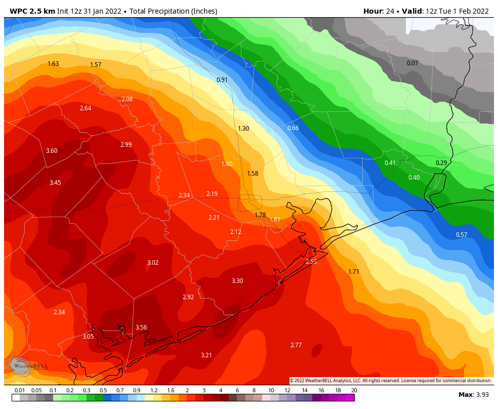
The greatest threat for heavy rainfall is likely near Matagorda Bay, and areas southwest of Houston, where higher isolated totals of 6 inches or more are possible. Due to the threat of some street flooding, we have instituted a Stage 1 flood alert for today and this evening. Note that these impacts are most likely during the evening commute. Highs, otherwise, will reach the mid- to upper-60s today, with lows in the upper 50s Monday night.

Tuesday
Congratulations. This is the one day with zero weather concerns this week. Expect highs in the low 70s with mostly cloudy skies. We may briefly see a little sunshine during the afternoon hours. Winds will be light. Overnight lows will again drop into the upper 50s.
Wednesday
This will be another warm-ish day, with highs likely reaching the mid-70s beneath cloudy skies. Some light showers will be possible during the afternoon hours, ahead of a front that will sweep through on Wednesday night, reaching Houston between midnight and sunrise on Thursday, and pushing off the coast by sunrise. Temperatures will drop sharply with this front, but most likely any rainfall accompanying it will end before temperatures get cold enough for wintry precipitation.
Thursday
Welcome to winter. Skies will be mostly cloudy on Thursday, with rains likely ending by or before noon. Your afternoon temperatures should top out at about 40 degrees, made to feel colder still by a stiff northerly breeze. The question becomes how cold it will get on Thursday night, and that is going to depend on whether skies clear somewhat (which would make things colder), and how quickly winds die down (more winds means more mixing, which would trend warmer). For now I think we’ll see mid-20s for inland areas such as Katy and The Woodlands, upper-20s for central Houston, and a light freeze right along the coast. This should be just warm enough to preclude concerns about widespread pipe damage, but the forecast at this point could still go a bit warmer or a bit colder.

Friday
Friday will be cold, with partly sunny skies, and highs in the low 40s. Expect another cold night with temperatures perhaps a degree or two warmer than Thursday night.
Saturday and Sunday
The weekend looks partly sunny and chilly. Expect highs of around 50 degrees on Saturday, with a light freeze possible Saturday night, and in the mid-50s on Sunday. We can’t rule out some light rain each day, but for now I’d bet on dry conditions. A slow warming trend should continue into next week.
I code for a living. I understand how difficult it is to deliver pristine apps. Based on my experience, it is almost impossible to do so. Sometimes it seems that bugs appear out of the ether. There is always a “gotcha.” Thanks for making the rest of us aware of the bug. I’m looking forward to the next release. Stay warm and dry, my friends.
I always tell people that Toasters have 2 buttons and they break all of the time! Apps can have millions of lines of code — it’s impossible to have a perfect app!
Love the transparency — but love the app (bugs and all) even more! <3
Why am I worrying about a power grid failure?
There is good reason to worry, Kyle.
https://www.wfaa.com/article/news/local/energy-experts-ercot-expect-power-to-stay-on-during-north-texas-freeze/287-d7b729cb-0963-4347-8d2c-c24af5b2dd08
You are worrying because the fear and panic news put the idea in your mind. It’s not going to go much below freezing, if at all, and won’t stay belong freezing long enough to cause any major problem. For years it has been typical to have night time winter temperatures in Houston in the upper 20s or low 30s.
The problem with grid failure isn’t freezing here (freezing rain might cause limbs to fall on power lines and cause outages, but that’s not grid failure). The problem is freezing in central and north-west Texas, where the wind farms are. It will be a lot colder there. Let’s hope it’s not too cold, and that enough has been hardened since last year. I think it’s likely that there will be no grid issues, though.
Yep – that and the gas wells and processing facilities in west and north Texas. I fear that there is little reason for them to have hardened much since they made so much money on last winter’s freeze. It probably won’t be cold enough, long enough for our nuclear units to trip like some did last year.
FYI it wasn’t wind farms that were to blame during the freeze. https://www.texastribune.org/2021/02/16/texas-wind-turbines-frozen/
Only 48 days until spring.
Can we hold off on that for a few more months? It starts getting hot in the spring.
now its almost 47. C’mon sun.
At 3:00 pm, Jan 31, we have 4 inches of rain north east of Bryan, TX – in the Reliance community area. Still coming down.