The song remains the same with regard to our hot forecast, so let’s discuss the four phases of summer

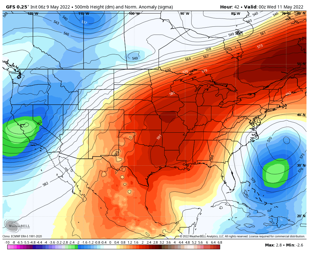
In my own mind I like to break summer in Houston into four phases. We can do this in Houston because “summer” season lasts so long, typically about five months. This is contrast to meteorological summer, which runs from June through August, and “solstice” summer, which runs from June 21 through September 22 this year. For me, Houston’s summer typically runs from about mid-May through mid-October. Here are the four phases:

  • Early summer: When we first start to see 90-degree temperatures with regularity, but some nights in the 60s are still possible, and there’s still the thinnest hope of a weak front
  • Mid summer: When highs run from 90 to 95 degrees, and nights are sultry, but you know it could still get worse
  • High summer: Somewhere between late July and early September there’s a period where temperatures reach the upper 90s to low 100s and you realize, “Ok, this really is the worst.”
  • Late summer: This is the period in September and early October when days grow shorter and we usually see the first front or two of the season. But most of the time it’s still hot.

This year, of course, Early Summer came about two weeks early. Here’s hoping Late Summer ends about two weeks early. But that’s not usually how things work, I’m afraid.

Tuesday

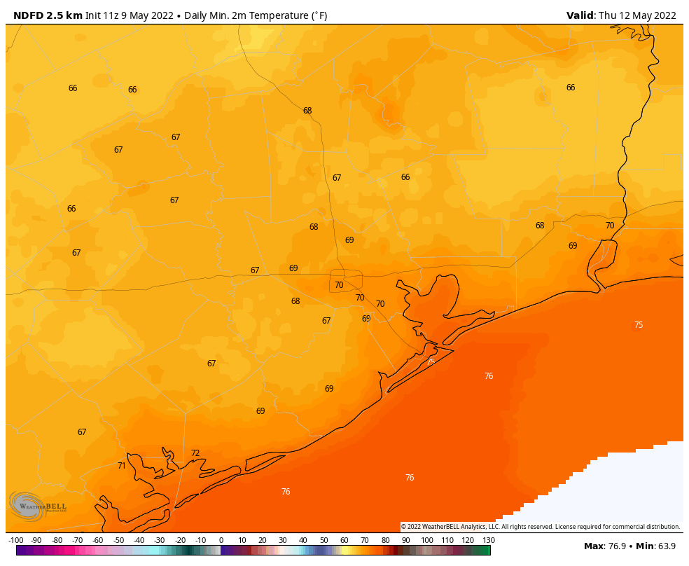
Today will be hot and sunny, with high temperatures around 90 degrees, or a touch warmer for inland areas. Winds will be out of the south at 10 to 15 mph with occasional gusts to 20 mph. Lows tonight will drop into the mid-70s, only.

This is the most hopeful map I can share this week. It’s the low temperature forecast for Friday morning. (Weather Bell)

Wednesday and Thursday

These days will also be hot, with daytime temperatures in the low 90s. But as high pressure shifts a little bit overhead, it will essentially weaken our southerly flow. This will diminish winds and very slightly turn down the spigot of humidity. So overnight temperatures may drop into the upper 60s for inland areas on Wednesday and Thursday nights, with slightly less daytime humidity. It isn’t much, but it’s something.

Friday

Look for highs in the low 90s with mostly sunny skies.

Saturday and Sunday

We’re still looking at very modest rain chances this weekend, primarily on Saturday and Saturday night. However I’d say the chance for most of Houston is probably about 20 percent, with areas east of Interstate 45 probably reaching 30 percent. Any accumulations look slight. Otherwise look for mostly sunny and hot days, with highs in the mid-90s.

And here’s a less hopeful map, the high temperature forecast for Sunday. (Weather Bell)

Next week’s big question

Is a pattern change coming to bring an end to this Early Summer heat wave next week?

Next week’s big answer

No.

Houston’s heat continues, with a slight mid-week downturn in humidity

After a hot weekend, with temperatures averaging about 10 degrees warmer than normal during early May, we’ll see a slight reprieve this week by Wednesday evening. But it will only be slight, and the latter part of this week looks to see continued hot weather. Our only foreseeable chance of rain will come next weekend, but I wouldn’t rate our chances at much higher than 30 percent right now.

Monday

To start the week we will see a continuation of conditions that prevailed over the weekend, which is to say mostly sunny weather with highs generally in the low-90s. Winds will continue to blow from the south, perhaps gusting to 20- or even 25-mph. Humidity will naturally be quite high as well. And overnight lows will not drop much below the mid-70s.

As we come into Wednesday, high pressure (deeper reds) will move almost directly over Houston. (Weather Bell).

Tuesday and Wednesday

This period will see more of the same weather, with highs in the low 90s, but this pattern will start to change by Wednesday afternoon or evening, as high pressure moves almost directly overhead. This will effectively put the brakes on the southerly flow, and help to bring a little bit more dry air into the region. We’re not talking anything crazy, but lows on Wednesday night should drop into the mid- to upper-60s for areas away from the coast.

Thursday morning’s low temperatures will be slightly cooler and drier. (Weather Bell)

Thursday and Friday

Both of these days will be hot, with highs in the low- to mid-90s. But some slightly lower dewpoints will make conditions feel a little bit less humid. Not much, mind you. But long-time residents will probably be able to detect a difference. Overnight lows should drop to around 70 degrees. Mornings and evenings will be fairly nice.

Saturday and Sunday

The outlook for the weekend calls for mostly sunny and hot weather, with highs in the low- to mid-90s. The only real question is whether a weak atmospheric disturbance will be able to provoke some showers on Saturday or Saturday night. Rain chances are probably highest to the east of Interstate 45, and even then are probably 30 percent or less. But it’s the most meaningful chance of rain we’re likely to see during at least the next 10 days, so it’s worth mentioning.

Next week

There’s not really much to suggest that our overall pattern will change much over the next 10 days, or longer. It will feel more like mid-June than mid-May, with temperatures generally in the low 90s. Summer, it seems, has decided to come early. Our luck.

Summer in Houston is unofficially underway

Well, here we are. It would appear that the summer of 2022 is going to begin quite early, as we are going to have multiple opportunities to approach or break record high temperatures over the next several days, with honestly no real confident end in sight.

Last night’s storms packed a punch in parts of the area, mainly up toward Huntsville. For the rest of us, just some rain.

Rain totals saw a wide disparity between over a half-inch north and mostly less than that south of Houston. (NOAA)

You can see rain totals on the map above, as estimated by radar. Mostly a half-inch to an inch north (more north of Conroe) and a quarter-inch to three-quarters of an inch south (highest in Chambers County). The only real “losers” with yesterday’s storms were south of Sugar Land, across southeast Fort Bend and much of Brazoria, Wharton, and Matagorda Counties, which saw less than a quarter-inch of rain.

Any rain is good rain at this point, so we’ll take it, as the drought monitor update released yesterday continues to show drought holding over most of Texas. Locally, the drought situation got a touch worse through Tuesday, with some expansion of drought south of Houston. Given the lack of rain there yesterday, this will almost certainly expand further next week.

Suffice to say, last night’s rain was appreciated, but some areas south of Houston saw very little of it, and those areas need it most. (US Drought Monitor)

We are now seeing levels of “extreme” drought show up in Matagorda County. With very little rain expected over the next 7 to 10 days, along with extremely hot weather for May, it is possible we see drought expand rapidly through the month. We will be watching this closely.

Today

So with the rain behind us, we now step into summer-like weather. We should see sunshine today after perhaps a little morning fog burns off in spots. Highs will bump up into the low-90s.

Weekend

We expect a sun-filled weekend, along with near-record heat for May. Temperatures will be in the mid to upper-90s both days with morning lows in the 70s. Combined with the humidity, it will feel like it’s over 100 degrees at times this weekend. Stay hydrated. Stay in shade. Our bodies need time to adjust to these levels of heat.

Next week

At this time, there is no reason to forecast any real rain through Friday. This means it will be sunny and hot with no relent. Expect highs well into the 90s and lows in the 70s each day. We’re not talking cheap 90s either; these will probably be 93-96 degree type days each day. In fact, if we look at the NWS forecast into next week and compare it to the record highs for those dates, you’ll see we’re currently forecast to tie or break records from Saturday through Thursday.

DayIAH Forecast HighRecord High (Year)
Friday92°94° (1906)
Saturday97°94° (1998)
Sunday96°96° (1967)
Monday96°94° (2011)
Tuesday94°94° (1927)
Wednesday94°94° (1890)
Thursday96°92° (1967)
Numerous record highs may be approached or exceeded over the next week.

We have not had an early to mid-May heat wave of this intensity in quite a few years, with only one record high set in the 2000s, one of the lengthier stretches that has not seen records broken much in recent years. So again, please stay cool this weekend and be extra cognizant of your exposure to the heat this early in the season. With that, some tips!

A Message From Our Sponsor, Reliant

As Houstonians get ready for our first taste of summer with temps in the high 90s starting this weekend, now is the perfect time to talk about how to prepare for the heat. Our sponsor Reliant shared the below helpful tips for staying cool while managing your energy usage.

  • Follow the 4×4 principle. Set your thermostat four degrees higher when you’re away from home for more than four hours to save on energy usage and costs.
  • Rotate your ceiling fan counterclockwise for a wind chill effect. This can make the temperature in a room feel up to 4 degrees cooler allowing you to be more comfortable and adjust your thermostat to save money. Don’t forget to turn off your fan when leaving the room.
  • Use blinds or curtains to reduce solar heat gain by up to 50 percent. Direct sunlight can increase the demand on your AC by as much as 30 percent.
  • Switch out your old light bulbs for new LEDs to light your home efficiently. Unlike incandescent bulbs that generate heat, LED bulbs are cool to the touch, last longer and use 70-90 percent less electricity.
  • Schedule an HVAC checkup. Now is a good time to arrange a tune-up with an HVAC service professional to ensure your system is running at its best. Just as you wouldn’t take your car out for a long road trip without getting serviced, you don’t want to enter summer without your AC system being properly maintained.

Find additional energy efficiency tips by clicking here.

Storms are possible this evening in Houston, bringing slightly cooler weather before a steamy weekend

Good morning. Houston will see a cold front move into the area later today and this evening. While the front won’t bring too much cooling, it will perturb the atmosphere to the point where there is now a reasonably high likelihood of seeing a line of storms move through the area. After tonight, a much warmer pattern will set in, with temperatures peaking in the mid- to upper-90s this weekend. Get your summer on, Houston.

Thursday

If your Cinco de Mayo plans include a fiesta later today, please note the potential for storms this evening. Temperatures today will rise into the upper 80s with a mix of sunshine and clouds, and we’ll see those familiar southerly winds gusting up to 20 or 25 mph. However later this afternoon and evening, a line of storms associated with the front is likely to form to the north of Houston, and push downward toward the coast. The high-resolution models have become more bullish on this line of storms holding up as it moves through Houston, with the main threats being straight-line winds and briefly heavy rainfall.

HRRR model of a simulated radar for 8 pm CT on Thursday in Houston. This is just a model. (Weather Bell)

I’d guess the line of storms reaches northern Houston around 6 to 8 pm, the central part of the city at sunset, and down to the coast an hour or two later. This is probably our last chance of rain for at least a week, so I’m not going to complain, and it now looks like most of the region will see 0.5. to 1.0 inch, with higher isolated totals. The storms should pass fairly quickly, clearing your location within an hour or two of arrival. In the wake of the front, temperatures may briefly drop into the 60s tonight, especially inland of Interstate 10, with slightly drier air.

Friday

With a bit of drier air in place, temperatures on Friday should shoot up into the lower 90s, with mostly sunny skies and light southwesterly winds. Lows on Friday night will bounce back into the 70s.

Saturday and Sunday

With high pressure building over the area, the weekend forecast is straightforward: Our entire region will see hot and sunny weather. Temperatures will probably peak in the mid-90s for most locations, but some western partners of the metro area almost certainly will move into the upper 90s. There will be plenty of humidity as well, so please do take care out in the daytime heat. Overnight low temperatures won’t drop much below the upper-70s.

High temperature forecast for Saturday. (Weather Bell)

Next week

Most of next week looks to be nearly as hot, with partly to mostly sunny skies, and highs perhaps in the low-90s most days. Rain chances are basically nil for as far as the eye can see after today and tonight.