Lingering rain chances in Houston this weekend before some heat early next week

While we lacked any organized storms on Thursday, there were some neighborhoods that saw a smattering of rain. Other places saw rain or heard thunder in the middle of the night. Rain chances will stick with us through Sunday, but the focus is going to lean more to our south or along the coast.

Today & weekend

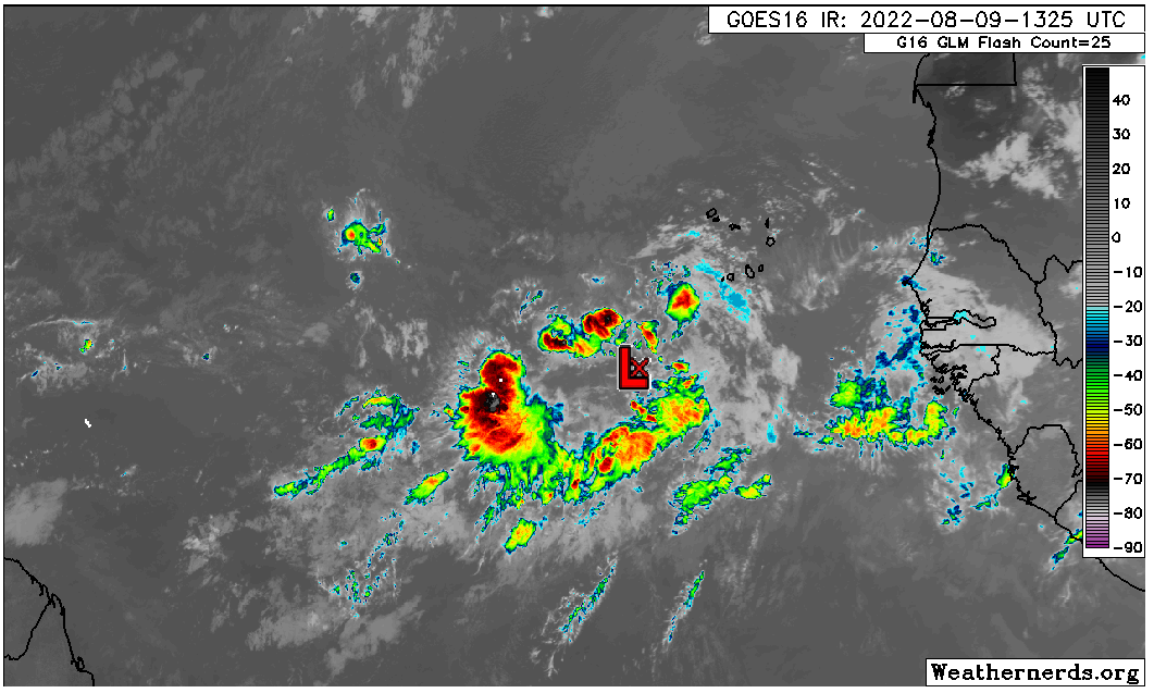
Radar this morning is buzzing from Houston to points southeast. Scattered downpours are with us.

Radar this morning shows showers and storms near Hobby Airport and Pearland, as well as more along the coast as of 7 AM. Click to enlarge. (RadarScope)

As the day progresses, the focus will continue to likely back down to areas closer to the coast. Inland areas will still carry a chance for rain as well, but most modeling (and the morning radar imagery) suggests the bulk of today’s showers will remain south and east of Houston. Low rain chances doesn’t mean no rain chances, and any rain that does fall could be heavy and add up to an inch or so over a short amount of time.

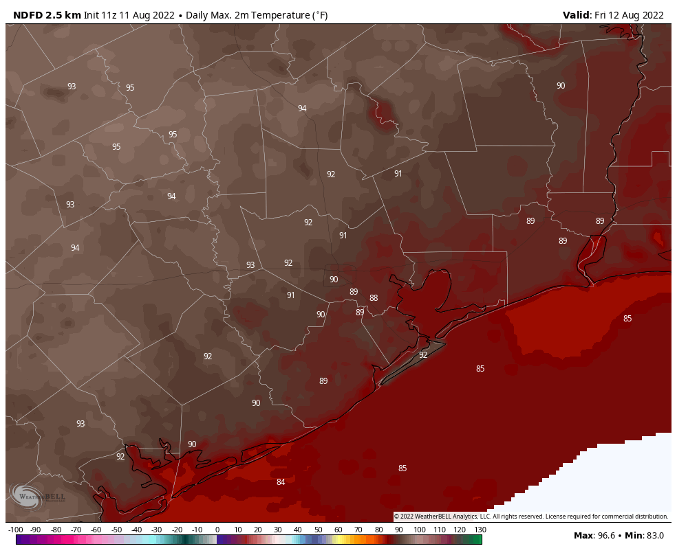
Highs will be variable today, ranging from the 80s near the coast to the low or mid 90s inland and perhaps near 100 in the Brazos Valley.

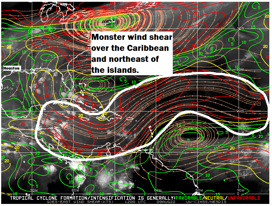
One wild card in the forecast the next few days is what’s happening in the Gulf. Recall from Tuesday’s Eye on the Tropics post, we noted that the Gulf would be the area to at least monitor.

A disturbance in the Gulf is not currently expected to develop into anything significant, but it will likely act to focus thunderstorm activity offshore at times this weekend as it tracks toward far South Texas. (Weathernerds.org)

Well, as of Friday morning, there is a disturbance in the Gulf, and while it’s not currently expected to develop, what it may do is focus shower and storm activity offshore at times this weekend. The system itself will track toward Corpus Christi or Brownsville, pushing inland on Sunday. Assuming showers and storms do focus closer to that system, that could mean that we see relatively low rain chances in the Houston area for Saturday.

So, for both weekend days, expect to see sun, clouds, and at least a few showers and storms in the area. The greatest coverage and highest chances will be along the coast, with chances dropping off significantly as you head north or west from Highway 59. All of us have some chance at rain this weekend, but your odds increase south and east of Houston. Sunday could see higher rainfall coverage a little more inland as winds become less parallel to the coast and more onshore. But we’ll assess that through the weekend and keep you posted.

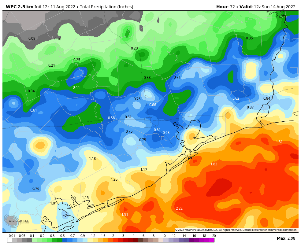
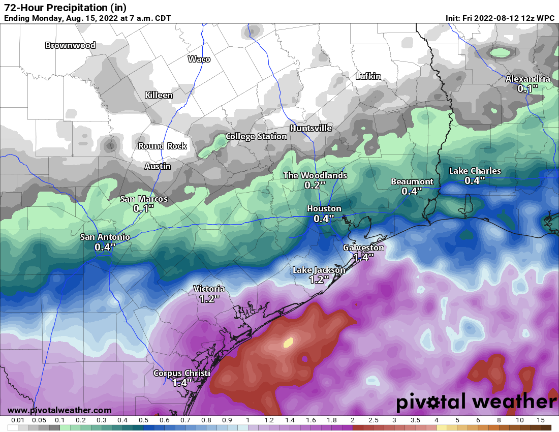
Total forecast rainfall this weekend (ending Monday morning) is shown below. While some areas will see more rain than this and others less, this map is a good average of where we think things will end up over the coming days.

Rainfall will hug the coast this weekend, resulting in higher totals for Galveston, Freeport, and the Matagorda Bay area than inland areas. Some places may see more rain than this, while others will see none at all, but this map suffices as an average. (Pivotal Weather)

Temperatures will be quite variable this weekend, perhaps only in the low 80s with clouds and showers on the coast, mid-90s in Houston proper, and upper 90s to near 100 well inland.

Early next week

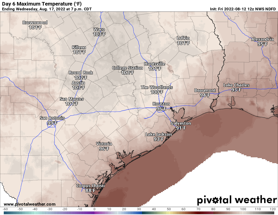
We revert back to the usual Summer 2022 fare Monday through Wednesday of next week. We will likely see mid to upper-90s in Houston, with 100+ farther inland and lower 90s at the coast.

Wednesday’s forecast high temperatures look fairly standard for Summer 2022, with lots of higher 90s and definitely some 100s peppered in there too. (Pivotal Weather)

Rain chances should drop to about 10, maybe 20 percent each day.

Later next week

I’ve been watching the weather model forecasts all week with some curiosity for late next week or weekend. There have been hints of a cooler, wetter pattern arriving across all of Texas on both the GFS & European models. While it’s too soon to get into details, it does appear we will see a chance at a front in the area, some “less hot” (not cool) weather, and potentially some higher rain chances than normal by next weekend. We have been burned by these scenarios more than once this summer, so I’m not exactly jumping in with both feet here. But there’s a healthy amount of evidence that rain chances will pick up further in 8 to 10 days. More on this Monday.

We’ll keep you posted on the rain chances this weekend with a post or two tomorrow or Sunday.

Houston to get a short break after Wednesday’s storms, but the atmosphere remains ready for more

As expected, a line of storms moved through Houston on Wednesday evening, bringing 0.5 to 3 inches of rain across much of the region in addition to damaging winds. In some of the strongest storms, wind gusts reached as high as 50 to 60 mph. The atmosphere remains pretty worked over after these storms, but it should recharge in time for additional rainfall on Friday and Saturday before the region returns to a hotter and sunnier pattern for a few days.

Thursday

Skies will be partly to mostly sunny today, with high temperatures likely climbing into the low- to mid-90s for much of the Houston area. Winds will be light, generally out of the north at about 5 mph. While the atmosphere is moist, it also remains a little bit more stable after Wednesday’s storms. That could start to change this afternoon or evening, however, with the sea breeze perhaps initiating some precipitation. At this point I would peg rain chances at about 50 percent area-wide.

Friday’s high temperature forecast looks pretty good for mid-August. (Weather Bell)

Friday and Saturday

These days should see healthy rain chances as an atmospheric disturbance moves in from the Gulf of Mexico. Showers should start offshore and propagate inland during the morning hours on Friday. With a moist atmosphere in place, these should be partly cloudy and cooler days, with highs generally ranging from 90 to 95 degrees, and light northerly or easterly winds. Rain chances are above 50 percent both days, as storms generally move from east to west. Right now I don’t expect thunderstorms to be as organized or intense as they were on Wednesday evening, but it’s something we’re watching for. Overall the region will probably pick up an additional 0.5 to 2 inches of rain, with coastal regions favored for the higher end of those totals.

NOAA rain accumulation forecast for now through Saturday. (Weather Bell)

Sunday

At some point this weekend, perhaps on Saturday afternoon or perhaps not until Sunday, high pressure will start to have more of an influence on our weather. This will tamp down rain chances and bring back the sunshine. As a result, for Sunday, I expect to see partly to mostly sunny skies, with highs in the mid-90s.

Next week

Beyond Sunday, the early part of next week looks fairly hot and mostly sunny, with high temperatures in the mid- to upper-90s for most of the Houston metro area. However, by Thursday or so a front will be approaching the region from the north. And while this front is unlikely to push into Houston, it should help to destabilize the atmosphere, bringing healthy rain chances back to the forecast by Thursday or Friday, and probably knocking highs back into the low 90s.

As moisture levels spike, Houston may see moderate to heavy rainfall into the weekend

Good morning. It has been a long, very hot, and mostly dry summer for Houston. For the next three or four days, however, we’re going to see a distinct pattern shift amid a weakness in the high pressure ridge that has dominated conditions since late May. This weakness, combined with a surge of tropical moisture, will bring healthy rain chances from now through Saturday, and should also knock high temperatures back several degrees. It won’t rain all of the time, but it should rain some of the time. Sunny and hotter weather returns early next week.

NOAA rain accumulation forecast for now through Saturday. (Weather Bell)

Wednesday

Skies will be partly sunny today, starting out like most recent days. Highs should climb into the mid-90s for much of the region, with the usual smattering of coastal showers and thunderstorms. The more significant change comes this evening, as what is essentially a dying front moves southward into the region. At some point around sunset, give or take a couple of hours, we should see a broken line of storms moving from north-northeast to south-southwest across the area. It is not entirely clear whether these storms will hit western or eastern parts of the metro area hardest, but expect a healthy chance of showers and thunderstorms between 4pm and midnight. The strongest of these storms will produce heavy rainfall, with damaging winds. Low-lying streets may briefly flood in the heaviest storms.

Thursday

Skies should be partly to mostly cloudy on Thursday, helping to limit high temperatures to the low 90s. Atmospheric conditions will continue to be favorable for rainfall, with chances of 60 or 70 percent for much of the area. Again, we expect showers to be hit or miss. Overall chances are probably better closer to the coast, and east of Interstate 45.

Friday and Saturday

This generally cloudier and potentially rainier pattern should persist into the first half of the weekend. Both of these days should see a mix of clouds and sunshine, with highs perhaps reaching 90 degrees, or slightly above. Rain chances both days are 50 percent, or perhaps even higher. All told, much of the region probably will pick up 0.5 to 2 inches of rain through Saturday, although some areas will see more, and alas, others less.

High temperatures toward the end of the week don’t seem unreasonable for mid-August. (Weather Bell)

Sunday and beyond

By Sunday we should start to see the influence of high pressure again, as skies become sunnier and rain chances start to slacken. By the middle of next week temperatures should climb to the mid- to upper-90s, and it will be plenty hot. However, the potential for rainfall may return toward the end of next week, providing us some additional relief. We shall see.

Eye on the Tropics: It’s beginning to look a bit like August

The tropics are beginning to resemble what is more normal for this time of year, but the good news at least for us is that there’s nothing of immediate concern on our radar. We will start to pick up the cadence a bit, however.

Tropical outlook in a sentence

While no activity is anticipated to directly impact Texas, there are several disturbances we will be watching over the next week or so.

Invest 97L

The first item up for discussion is Invest 97L, way out in the deep Atlantic. Recall, invests are just a naming convention for disturbances that the National Weather Service believes merit further investigation. They cycle from 90 to 99 and then repeat. It allows us to see more data, input better data into our regular weather models, and see some initial runs of specialized tropical models on the disturbance.

In this case, Invest 97L is chugging along southwest of the Cabo Verde Islands.

A look at Invest 97L this morning is rather uninspiring. Nevertheless, some models do develop this as it comes west. (Weathernerds.org)

The satellite image above does not inspire much enthusiasm for this disturbance at this point. It has a minimal amount of thunderstorm activity (convection) around it, and it seems to be struggling a bit in a rather hostile Atlantic environment. If the first batch of wind shear near it does not completely shred it, the second batch just east of the islands probably will.

Wind shear is quite expansive and impressive between the Caribbean and the open Atlantic, which will make life difficult for any developing systems as they come west until it dissipates. (University of Wisconsin)

With this sort of wind shear around right now, it would seem that anything coming west is going to struggle. Weather models are split on how this looks over the next week or two, with the GFS knocking back the shear some, and the European model keeping the party going. But as long as this shear is in place, it’s good news for us with respect to anything coming off Africa.

The starting lineup

Speaking of, the “wave train” predicted to emerge off Africa is rather congested right now. We have two in line to emerge over the next week or so, and there’s a third in eastern Africa that should emerge sometime next week.

There are several disturbances waiting in the wings to emerge off Africa over the next 10 days or so. While none appears to be a significantly viable development candidate, it’s August, which means we’ll be watching. (NOAA)

While these disturbances are lined up and ready to play in the Atlantic, again, the wind shear story is one that will have to change for any of them to have a chance. It’s also somewhat notable that there’s a pretty healthy gap between the first two disturbances and the third one. Quiet in late August would be rare. All in all, you probably couldn’t paint a better picture right now in the Atlantic; some activity to watch but nothing imminent.

Gulf update

Seasons like this can lull you to sleep, but I want to just close today with a look at the Gulf. Because of the situation in the Atlantic, the most risk in Texas for the rest of August may come from something much closer to home in the Gulf. Do we see anything worth watching? The short answer is no.

The longer answer is that we have a couple fronts trying to nudge their way to the coast over the next week or two that we should probably keep a side eye on. But at this point in time, there’s nothing signaling anything of legitimate concern.