Houston to sizzle this week, and tracking a new tropical system headed to the Caribbean Sea

Good morning. Houston has one more week of exceptionally hot September weather before the pattern should change, with an increasing likelihood of a decent front pushing into the region. In this post we’ll also discuss the potential for a tropical system to move into the Gulf of Mexico next week.

Tuesday

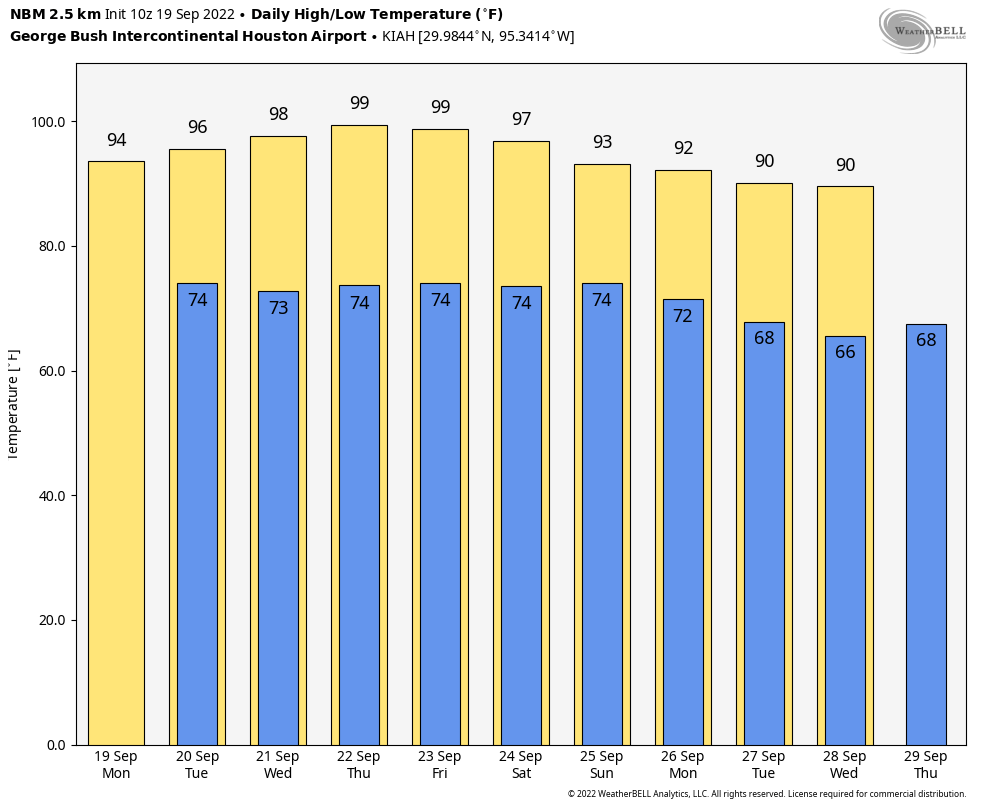
Temperatures maxed out in the low- to mid-90s across Houston on Monday, and conditions will be similar today under mostly sunny skies. But whereas about 20 percent of the region saw a passing shower or thunderstorm, that number is probably 10 percent today. And if you think that is low, wait until you see the precipitation forecast for the remainder of the week. Winds will be light, out of the east at about 5 mph. Lows tonight should drop into the low 70s.

Wednesday

Look for sunny conditions, and highs in the mid-90s. Rain chances will be near zero.

High temperature forecast for Thursday. (Weather Bell)

Thursday and Friday

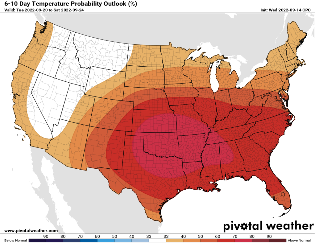
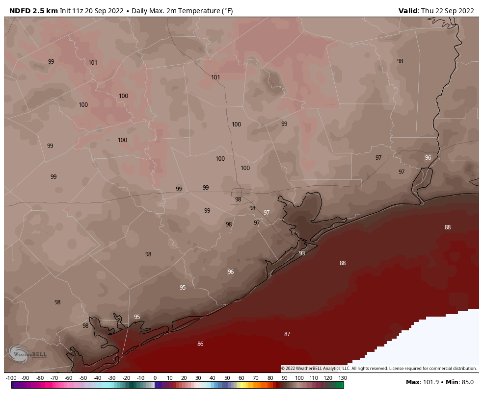
A ridge of high pressure will reach its peak toward the end of this week, and it’s going to push high temperatures to the upper 90s, and for some inland locations, possibly 100 degrees. This is very late in the year for such hot days. In nearly 150 years of records, the latest 100-degree day ever recorded during the calendar came on September 27, 2005. (Friday is September 23). Rain chances are zero each day, with sunny skies.

Saturday and Sunday

As the aforementioned ridge starts to retreat a bit, we’ll see high temperatures back off slightly. But I’d still anticipate highs in the mid-90s, with sunny skies, on Saturday and Sunday. A few scattered showers and thunderstorms are possible by Sunday, but at this point I’d peg chances at 20 percent or less.

Next week

While the pattern is not yet set in stone, it now appears likely that a cold front will push through on Monday or so of next week, and this should bring some notably drier and cooler air. Don’t expect miracles from the first front of the year, but we should see nighttime temperatures drop into the 60s for inland areas, with dewpoints comfortably in the 50s.

Tropics

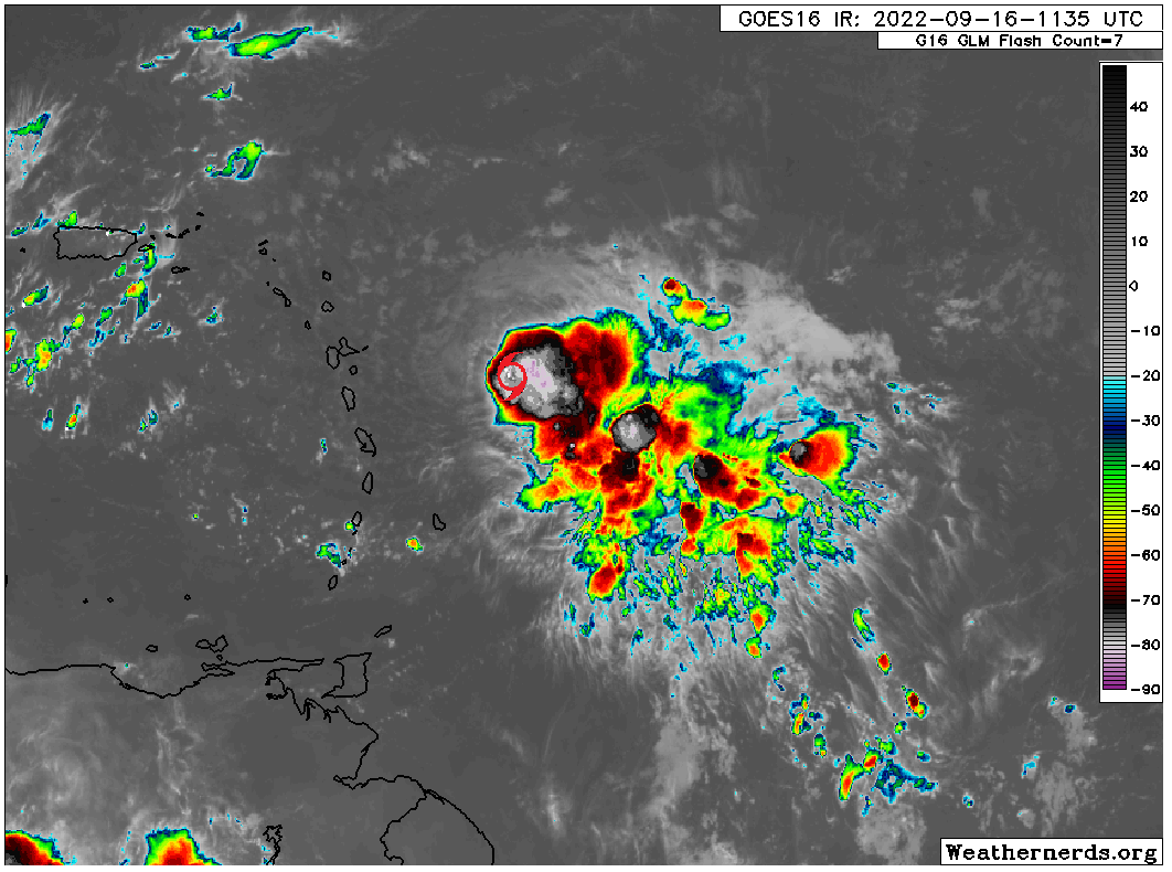
Fiona is now a major hurricane pulling northward of the Dominican Republic, and it will affect Turks and Caicos and the southeastern Bahamas today. In a few days, the storm could threaten Bermuda.

Of more interest to the continental United States is a tropical wave in the Atlantic Ocean, a day or two away from entering the Caribbean Sea. Global models have become more bullish on the development of this system during the last 24 hours, and it has a plausible path to reach the Gulf of Mexico in a week or ten days from now. Here’s a map of the European ensembles for this system, one week from today:

European model ensemble forecast for 1 am CT on Tuesday, September 27. (Weathernerds.org)

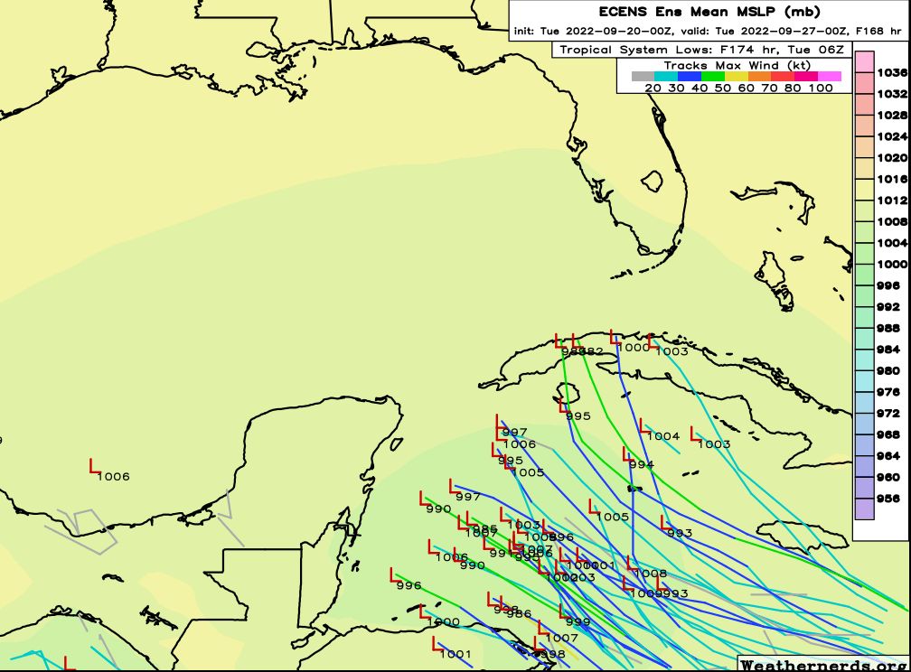
There is good agreement here about a tropical system reaching the western Caribbean Sea early next week. Importantly, this is about as far as we can reasonably rely on model guidance. After five to seven days, the accuracy of such models breaks down. And indeed, when we run the forecast forward just two days, to Thursday September 29, there is an extremely wide variance of outcomes. Some of the models start to turn the storm northward toward Florida, and others continue to push it westward toward the Gulf of Mexico, where it could wind up anywhere from Mexico to the Florida peninsula.

European model ensemble forecast for 7 am CT on Thursday, September 27. (Weathernerds.org)

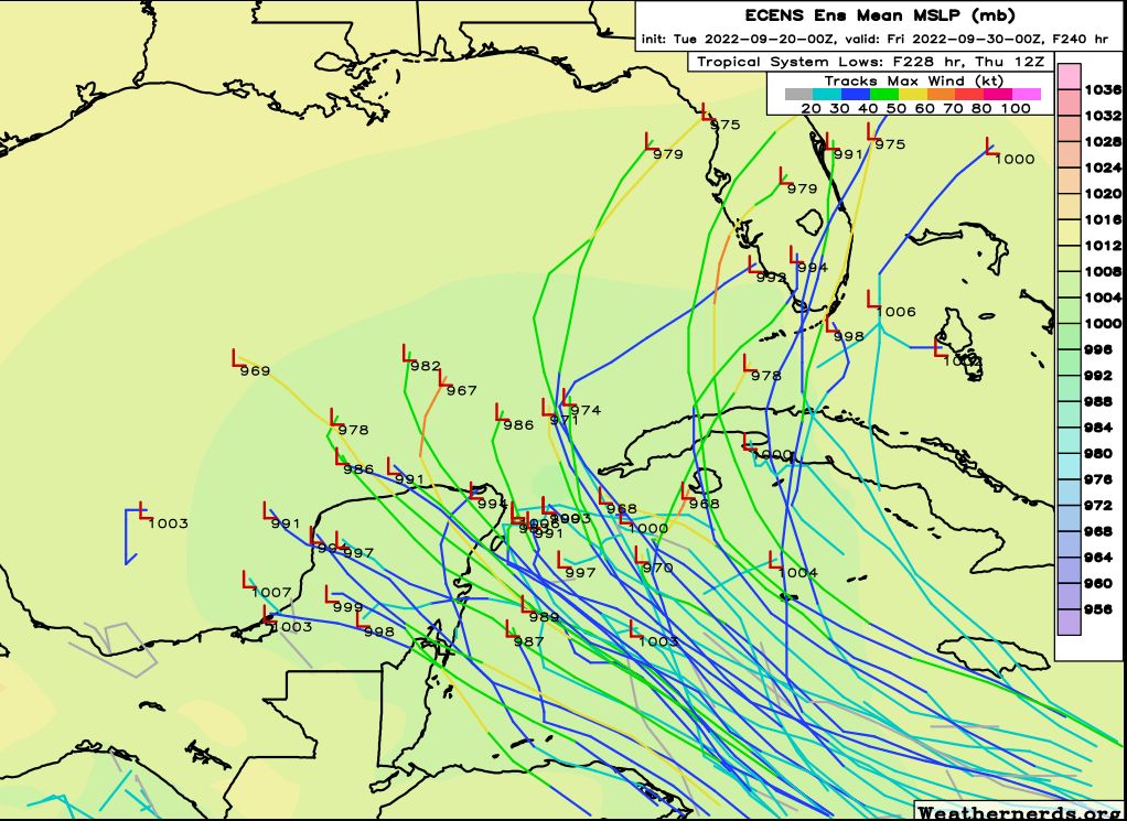
So what does all this mean for Texas? We are fast reaching the time of year when it is less likely for storms to track into Texas, but that does not mean it’s impossible. In this case, the models are sending a strong signal that this system will develop in the Caribbean Sea, and become a tropical storm or a hurricane. After that time it may very well move into the Gulf of Mexico, but there are just too many variables to sort out before we can have any confidence in where it will go. Our best forecasting tools are just not up to the task of delineating a clear track for a tropical system that has not yet formed, nine or ten days from now.

Bottom line: If you’re living near the Texas coast, this is not something I would lose too much sleep over. But it’s definitely worth watching, and we’ll be doing just that.

‘Second summer’ should reach its crescendo this week in Houston

As Matt so accurately wrote on Friday, a “second summer” has descended upon Houston. It will reach its peak this week, and conditions will be pretty brutal for late September, with high temperatures nearing or possibly surpassing 100 degrees. The good news is that we do see a light at the end of the tunnel, with the potential for a decent cold front pushing into Houston next week. This is not something we can guarantee yet, but I would say that if you can hold on for about one more week of Houston summer, we probably should start to transition into more fall-like weather soon.

But yeah, this week is going to be brutal.

Monday

Today will bring more weather like we experienced on Sunday, with mostly sunny skies and highs in the mid-90s for much of the region. We will again see the potential for some isolated to widely scattered showers, with chances only in the 20 percent range for coastal areas, and perhaps 10 percent for inland areas. Winds will be light, out of the east at 5 to 10 mph. Lows tonight drop into the mid-70s.

This week is going to see some brutal heat, Houston. (Weather Bell)

Tuesday, Wednesday, Thursday, and Friday

The middle of this week will be hot, hot, hot. High pressure will dominate our weather, and this is going to drive temperatures into the upper 90s and possibly 100 degrees for areas well inland. Thursday looks like the hottest day of the week. There is no way to sugarcoat what is going to be anomalously warm, potentially record heat for late September. Rain chances will be near zero after Monday.

Saturday and Sunday

High pressure starts to back off some this weekend, but I think we’ll still be solidly in the mid-90s in terms of temperatures, with mostly sunny skies. Rain chances remain fairly low, but it’s difficult to rule out precipitation this far out.

Next week

Much, but not all, of the model guidance shows a pretty decent cold front arriving in Houston next Monday or Tuesday. This is far enough away that we cannot fully buy into it yet, but at this point I think the chances are better than 50-50. This front has the potential to drop highs into the 80s, and lows into the 60s, and could be strong enough that I’d classify it has Houston’s first “real” front of the season. We should have a more definitive answer on the front in a couple of days, and obviously we’re watching it closely.

Hurricane Fiona flooded Puerto Rico this weekend. (National Hurricane Center)

Tropics

Hurricane Fiona, with sustained wind speeds of 90 mph, ravaged the island of Puerto Rico this weekend, knocking out power to the entire island and dropping 1 to 2 feet of rain. The US territory will need our help in the weeks ahead. The storm is beginning to turn northwest, affecting the Dominican Republic, and will eventually turn northward and threaten Bermuda.

Beyond Fiona there’s not much to write home about. We are getting close to the end of the Texas hurricane season, but I’m not quite ready to declare it over yet. But soon, probably. Check back Thursday.

The transition to August lite weather is underway

Eric and I kid with each other often because I personally hate September more than August, whereas most rational people hate August. My reason for hating September is exactly what is happening this year. We got teased with fake fall weather this week, and what’s coming next week looks kind of like “August-lite” type weather. Alas, it won’t be quite as miserable as a typical August, but any dreams of autumn breezes and cooler days are on hold.

Today

Yesterday, we got some showers to drop rain for coastal areas. Parts of Galveston saw just shy of an inch, and rural portions of Brazoria and Matagorda Counties saw 1 to 3 inches. We even saw some rain west of Rosenberg back into Wharton County.

Showers have already blossomed near the coast this morning. Expect an eventual shift inland for some showers later today. (RadarScope)

Today’s rain will be more spread out I think. We are initially seeing some scattered showers this morning near Bolivar and along the coast. The focus should remain in those areas for awhile, but inland areas will at least have a shot at showers this afternoon. The guidance for today is that you probably won’t see rain, but if you’re one of the lucky ones that do, it could rain hard for a brief period of time. Highs will be in the 80s or low 90s.

Weekend

Saturday looks a lot like today, with an isolated shower or storm possible almost anywhere, though the focus will be near the coast again and most inland communities will remain rain-free. Sunday should see rain chances dwindle a bit, so even fewer places will see a shower or storm. Both days should be in the low-90s on average. Morning lows will be in the 70s, and winds this weekend should be out of the southeast around 5 to 15 mph, or a bit gusty over the water.

Next week

Second Summer is here. Monday through Wednesday won’t have zero rain chances, but they’ll be low. Look for a lot of sun and a lot of heat. After morning lows in the low-70s, we’re probably looking at successive days in the mid-90s.

The peak of next week’s heat will probably come on Wednesday, when we should easily get into the mid-90s, with risk for even a bit hotter in spots. (Pivotal Weather)

Right now, it looks like the ridge over us will peak on Wednesday, but heat will linger into Thursday and Friday also. Record highs next week are generally 96-100 degrees, so we will be flirting on the lower end of that. Don’t look for much relief before next weekend. The earliest we could see our next cold front is probably not until sometime the week of the 26th.

Tropical Storm Fiona

Let’s talk about Fiona. I’ll answer the obvious question right away: Fiona is not expected to make it to Texas or the Gulf at this time. Still, it’s something to at least keep an eye on in case things change.

Fiona has a good bit of thunderstorm activity with it, but one thing is for sure: It’s lopsided, with most storms on the east side and very little on the west side. Thus, Fiona is one disorganized storm.

Tropical Storm Fiona looks impressive, but it’s a very lopsided storm, indicating that it’s struggling a bit. Still, conditions in the Lesser Antilles should deteriorate later today and tonight, particularly in the northern half of the islands. (Weathernerds.org)

Fiona is expected to move into the northern half of the Lesser Antilles later today, bringing rain and gusty winds. It will then likely bring rough weather to the Virgin Islands and Puerto Rico later tomorrow into Sunday.

Fiona currently has maximum winds of 50 mph. As it moves into the islands, it is not expected to strengthen a whole lot more. It may gather some steam later this weekend, but that’s a big question mark. The current National Hurricane Center forecast brings it to Hispaniola by Monday.

The NHC forecast keeps Fiona a tropical storm over the next 5 days, eventually turning it toward the north somewhere between Hispaniola and Cuba early to mid next week, though many questions remain. (NOAA)

From Hispaniola, the forecast gets more difficult. A vast majority of models turn Fiona northwest or north at this point, eventually strengthening it enough near the Bahamas to turn it out to sea. However, given land interaction, it’s plausible to think Fiona will struggle a bit in the coming days. Personally, Matt is leaning toward Fiona following the southern fringe of the NHC cone above. This still turns it more northwest near Cuba, but maybe not as soon as we’d like. On the flip side, it’s possible to think there’s enough land interaction to weaken Fiona substantially at some point, perhaps to the point of no return. But never count any system out in September in the southwest Atlantic or Caribbean so we’ll see.

All this is a long way of saying: Fiona will probably turn north or meet its demise before getting to the Gulf, but there’s enough uncertainty regarding the different puzzle pieces to impact this storm that it’s prudent to check back in on Monday and see where we stand. We’ll have more then.

The mild cool front was nice, but summer will roar back into Houston next week

Good morning. We are now about half-way through the month of September, and so far this month Houston has enjoyed slightly cooler than normal conditions. Looking ahead, however, it does appear as though the second half of the month will be warmer than normal, with highs climbing back into the mid-90s for much of next week, and possibly beyond as a high pressure ridge builds over the region. The good news is that, despite the formation of Tropical Storm Fiona in the Atlantic Ocean on Wednesday, we have few local concerns about the tropics during what typically is the peak of the season for the Gulf of Mexico.

Thursday

A bit of dry air is holding on this morning, but low temperatures across Houston are generally warmer than they have been the last couple of days. This trend will continue as the onshore flow establishes itself, and pushes humidity levels back up to summertime levels this weekend. Highs today will likely reach about 90 degrees, or slightly above, under mostly sunny skies, with light winds. Areas south of Houston, particularly near Matagorda or Galveston bays, have a slight chance of seeing some afternoon showers and thunderstorms. Lows tonight will drop into the mid-70s for most of the area.

NOAA rain accumulation forecast for now through Sunday. (Weather Bell)

Friday and Saturday

Atmospheric moisture levels should spike on Friday and Saturday, and this will lead to some reasonably healthy daily rain chances in the range of 50 or 60 percent for coastal areas, up to about Interstate 10. The northern half of the region, however, is likely to remain mostly dry. This could be a situation where the coast picks up 1 or 2 inches of rain, and areas such as Tomball or The Woodlands maybe catch a sprinkle here or there. Highs, otherwise, will be in the low 90s with mostly sunny skies.

Sunday

This should be another mostly sunny day, but with rain chances perhaps half that of the previous two days as high pressure starts to build over the area. Expect highs in the low 90s.

Alas, next week looks fairly hot across Texas. (Pivotal Weather)

Next week and beyond

There is no way to sugarcoat things about next week. As high pressure comes back into play, the region is going to see fairly warm conditions, with high temperatures likely in the mid-90s. With the sea breeze the atmosphere may be able to squeeze out a few showers during the afternoon, but for the most part these should be mostly sunny days. I don’t see anything significantly changing until at least next weekend, and perhaps not then. Our next cold front is probably not coming for at least 10 to 14 days, and while there are some hopeful signs in the models at that time, there’s no guarantee of one then. So yeah, summer’s back.

Tropical Storm Fiona will bring windy conditions to some Caribbean isles this weekend. (National Hurricane Center)

Tropics

Tropical Storm Fiona formed on Wednesday, and it should affect Puerto Rico, the Dominican Republic, and other Caribbean Island this weekend. But as we’ve been suggesting for a couple of days, this system is very probably not bound for the Gulf of Mexico, and in fact it should turn north before approaching Florida or the Southeastern United States. Beyond Fiona the tropics are fairly quiet, which is great for mid-September.