A mixed weekend as we watch potential for a Tuesday soaker for Houston

Happy Friday to those of you celebrating. I just want to give a quick thanks to Eric for covering me last Friday, as I attended the American Meteorological Society’s annual meeting in Denver. I also got to give a talk about the Space City Weather Flood Scale, and we may have some opportunities to partner up with some experts to improve it, something I’m excited to wade into (pun intended). The talk should be publicly available to view in a couple months. I’ll let you know when that happens.

Our forecast today features a bit of a mix, including two fairly decent rain opportunities, one tomorrow and another next week.

Today

Clouds will be on the increase today have arrived today, as the first of our two systems comes this way. Yesterday was sunny and pleasant. Today will be cloudy and cool. High temperatures should check in about 15 degrees cooler than Thursday, with most areas not escaping the mid or upper-50s. As far as rain goes, sprinkles and/or showers will begin to spread from southwest to northeast as the day progresses. Most places should see some form of rain by this afternoon.

Tonight into Saturday

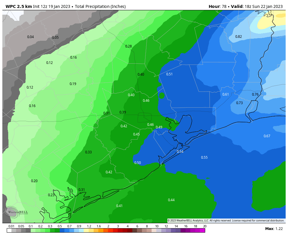
While it probably will not rain all night tonight, there will be periods of drizzle, light rain, and moderate rain likely at times through the night. A stray rumble of thunder is also possible. These waves of showers and rain will continue pumping in through much of Saturday. Again, it’s unlikely that it will rain everywhere all day. But you’ll need an umbrella at the ready wherever you are.

Rain totals should be under an inch in most spots through Saturday, but they may be erratic, with some areas only seeing a couple tenths of an inch or so. (Pivotal Weather)

This is unlikely to be a soaker for most of the area, but we will see some places with a decent amount of rain, perhaps close to an inch or so. Other areas will only see a couple tenths of an inch or so.

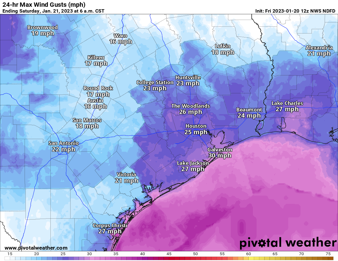
In addition to the rain, it will be rather breezy, especially over the water and near the coast. Winds of 15 to 25 mph will be likely, along with some higher gusts, especially in the morning on Saturday. That’ll add some chill to the air.

Wind gusts may approach 30 mph along the coast through Saturday and even a bit stronger offshore. Small craft advisories are posted. (Pivotal Weather)

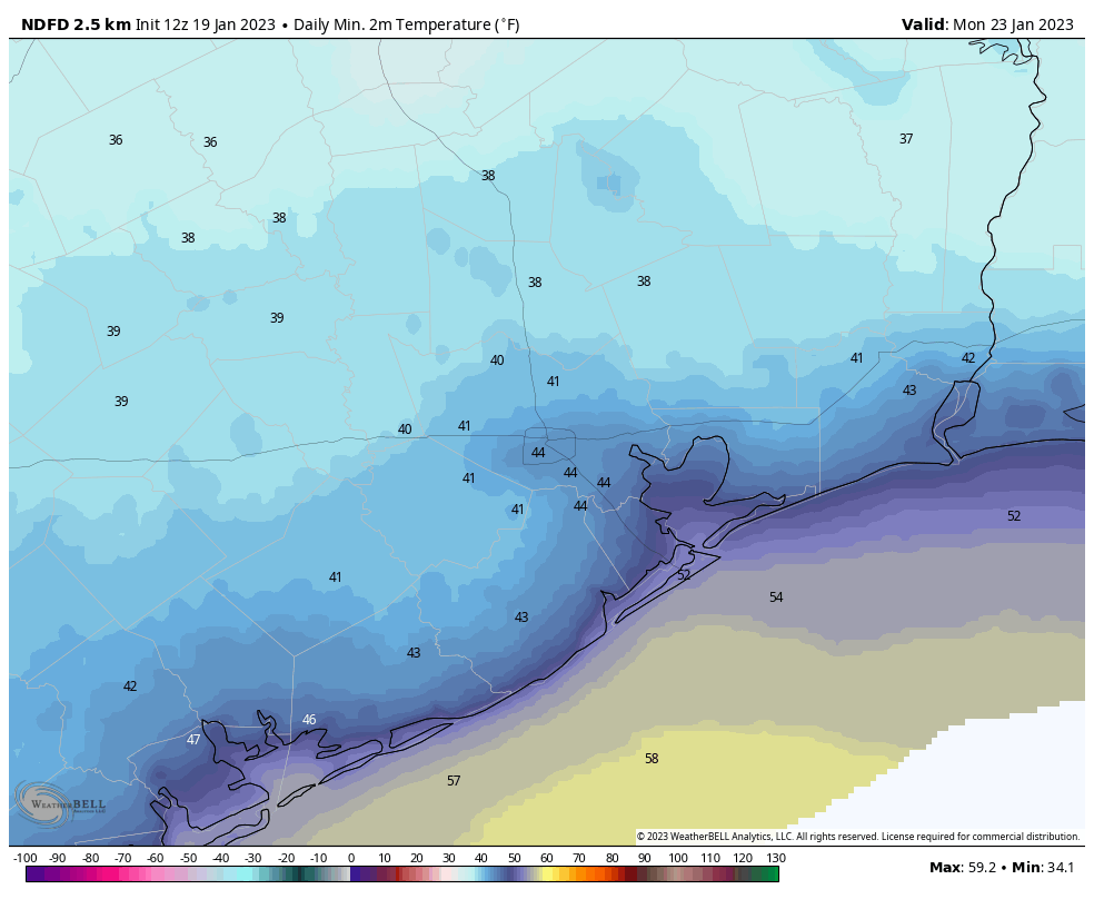
Temperatures will fall back into the low-50s Friday night and Saturday morning before climbing back into the mid or upper-50s Saturday afternoon.

Sunday

The second half of the weekend looks lovely, with sunshine, less wind, and highs around 60 degrees after morning lows in the 40s or upper-30s.

Monday

I would expect mostly a repeat of things Monday, although clouds may increase a bit later in the day, and temperatures will warm from the low-40s into the mid-60s.

Tuesday and beyond

If there is one day worth watching in terms of weather, it’s Tuesday. Modeling has been fairly inconsistent on the exact details of this next system, but a couple things are known. There is likely going to be a storm system that develops in Texas. It will bring both rain and wintry precipitation to the state (just rain here in Houston). But depending on the exact strength and track of this system, we could be in for some strong or severe thunderstorms Tuesday in the Houston area.

The Weather Prediction Center’s forecast for Tuesday shows developing low pressure over Texas that will bring us widespread rain and at least the chance for strong thunderstorms. (NOAA)

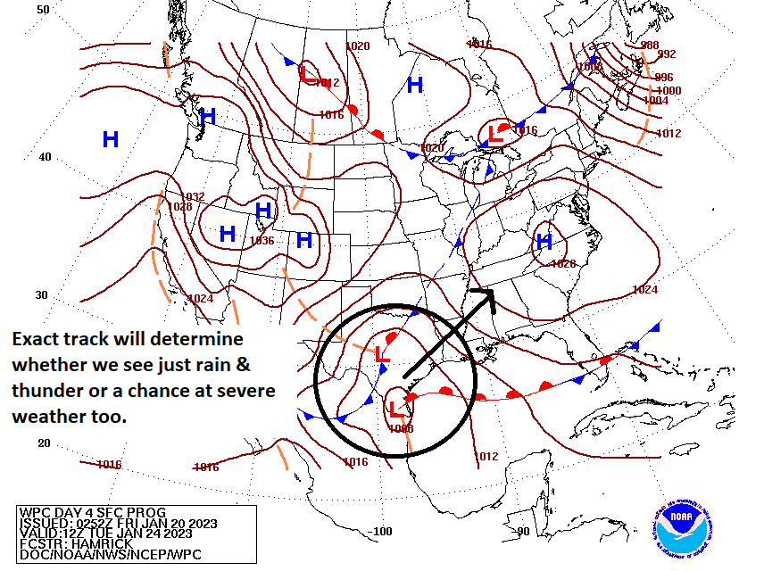
Right now the warm front is expected to be just offshore, which keeps our instability and chances at severe weather rather low. However, if this shifts farther north any, we could be in for a forecast change. So you’ll want to check back with us on Monday. In addition to an inch or locally more of rain, I would expect some pretty healthy wind on Tuesday too.

If you are planning any travel to North Texas, Oklahoma, or the Panhandles there is a pretty decent chance that snow or ice could be an issue. This is primarily true for Lubbock and Amarillo into Wichita Falls and Oklahoma, but I would also watch the DFW Metroplex and Abilene as well.

Odds from the early morning European ensemble of at least 3 inches of snow on Tuesday. The best chance of snow is north of I-20 into the Panhandle and Oklahoma, but the chances are not zero for Dallas. (Weather Bell)

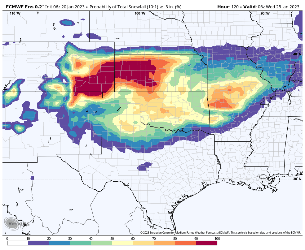
We have a long way to go here, so specific details are impossible to flesh out, but this could be an impactful storm for parts of the state. After this storm passes, we look good for a few days, with highs mostly in the 50s and lows in the 40s or upper-30s.

The remainder of January is really going to feel like January in Houston

Good morning. A front pushed into Houston on Wednesday afternoon, dropping temperatures and humidity in its wake. After a mostly sunny day today, with highs near 70 degrees, it would not surprise me if we don’t see the 70s again for the rest of this month as a series of fronts keep us on the cooler side. At the same time, I also don’t expect anything too extreme, in terms of cold, with lows mostly in the 40s and no freezes on the near-term horizon.

Thursday

If you were up early this morning like me, you will have appreciated the clear skies and the waning crescent of the Moon. Skies will be mostly sunny today, with a northerly flow that may see winds gusting up to 15 or even 20 mph this afternoon. Dewpoints will drop into the 30s, which means that our air will become pretty dry this afternoon. However, we’ll start to see the development of some clouds this evening, and mostly cloudy skies should hold overnight lows to around 50 degrees in Houston, with cooler conditions further inland.

Friday

The aforementioned clouds will continue to build on Friday as a coastal low pressure system moves up the Texas coast. These clouds, combined with a northeasterly breeze gusting to 15 or 20 mph, should act to hold high temperatures in the upper 50s on Friday. Lows will drop a few degrees overnight, and we may see some scattered showers as the low approaches the greater Houston region.

NOAA rain accumulation forecast for Saturday. (Weather Bell)

Saturday

As we’ve been saying for awhile, the first half of the weekend looks wet. Not disruptively wet, in terms of flooding, but annoyingly wet in terms of on- and off-showers that perhaps drop on the order of one-half inch of rain throughout the day. The favored time for these showers will be the daylight hours, with rain chances slackening as evening comes on. Most of the area will see highs of around 60 degrees. A reinforcing cold front arrives Saturday evening, or so, to help drop overnight lows into the upper 40s.

Sunday

The second half of the weekend should be sunny and splendid, with highs of around 60 degrees. Winds may be a little gusty during the morning hours, but they should back off some during the afternoon hours. Low temperatures on Sunday night will drop into the mid-40s in Houston, with colder conditions further inland.

Low temperatures for Sunday night in Houston. (Weather Bell)

Monday and Tuesday

We’re going to see a brief warmup to start next week, with highs on both of these days perhaps in the mid-60s or so. However, in what will seem like a recurring pattern, some moderate rainfall will be possible during the daytime on Tuesday as yet another front moves through. Lows drop into the low 40s on Tuesday night, probably.

Remainder of next week

Most of the rest of next week, at least through the work week and possibly into the weekend, will see chillier weather. I’m thinking highs in the low 60s and lows in the low 40s, but of course there will be some variation. After the first two thirds of January were very warm, it looks like the last 10 days of the month will see a return to normalcy.

Scattered showers today will herald the arrival of a front, and return of more typical January weather

Houston’s Hobby Airport set a record high temperature, with a mark of 81 degrees, and many other locations across the region hit 80 or higher on Tuesday. We’ll be warm again today ahead of a front that should push into the metro Houston area shortly after noon. This will be the first of a series of fronts that keeps us on the cooler side of things for at least the next week, and probably longer.

Wednesday

Highs today will likely reach the mid- to upper-70s ahead of the front, with partly sunny skies. A broken line of showers and thunderstorms will form late this morning to the northwest of Houston, and then move through the region toward the coast during the middle of the day. While I can’t rule out some severe weather, it does not appear as though the ingredients for stronger storms will line up over Houston. These remain more likely for areas such as Cleveland, Texas, and areas to the northeast. Drier and cooler air moves in behind the front, ending rain chances this afternoon. Lows on Wednesday night will drop to around 50 in Houston, with colder conditions inland.

The better chances for severe weather will be to the east-northeast of Houston. (NOAA)

Thursday

This will be a partly to mostly sunny day with highs in the upper 60s to 70 degrees and much drier air. Winds will be out of the north at about 10 mph. Lows Thursday night should drop into the upper 40s in Houston.

Friday

Skies will be mostly cloudy on Friday, with highs of around 60 degrees. As the flow turns more southerly, we’ll see atmospheric moisture levels start to ramp up. As a low pressure system starts to work its way northward along the Texas coast, this will start to introduce a chance of showers on Friday evening or Friday night. These should be mostly light, however. Lows will fall into the low 50s.

Saturday

This will be a cloudy day with intermittent rain showers. Highs, again, will be in the low 60s. We’re not looking at anything too extreme in terms of rainfall, but pretty much every part of the metro area should see on-again and off-again showers, with accumulations of 0.25 to 1 inch of rain for the most part. I cannot rule out a few scattered thunderstorms, but I think these will stay offshore for the most part. Rain chances start to back off on Saturday evening as the low pressure system moves away and we see a drier northerly flow. Lows drop into the upper 40s on Saturday night.

NOAA rain accumulation forecast for this weekend. (Weather Bell)

Sunday

We can be reasonably confident in nice weather on Sunday, with mostly sunny skies and highs in the low 60s. Lows on Sunday night will be cooler, dropping into the low 40s in Houston, and colder still further inland.

Monday

This probably will be another partly to mostly sunny day with highs in the low 60s.

The rest of next week

We start to warm up a bit on Tuesday, with a more southerly flow. However, another front is on track to arrive Tuesday, bringing with it a decent chance of rain and keeping conditions on the cooler side for the remainder of next week. Most likely we’re looking at highs in the low 60s, and lows in the low 40s, or thereabouts for awhile.

A return to winter-like conditions is finally on the horizon for Houston

Good morning. With winter about one-half over, I thought we might take a moment to look back at what has come, and look forward to what is left. Although the region experienced a deep freeze during the days preceding the Christmas holiday, it has otherwise been a rather warm season. Overall, the month of December finished with an average temperature 1.7 degrees above normal. January, so far, has been very warm. The month’s average temperature of 62.3 degrees is running 9.1 degrees above normal.

To date, January has seen considerably warmer than normal weather. (National Weather Service)

After today and Wednesday, however, it looks like the rest of January will see more seasonable weather. I expect near normal, or slightly below normal, temperatures during the last 10 days of the month. In other words, our flirtations with 80-degree days probably will be over for awhile. February is the last month of the winter that typically can produce sustained, deep cold weather. Seasonal model guidance—which is not particularly reliable—suggests February will see near normal temperatures.

If you’re wondering about a freeze, the average date of the “last freeze” in Houston comes about one month from now in the city of Houston; sooner for the coast, and later for areas further inland. I give the city of Houston about a 10 or 15 percent chance of seeing sub-freezing temperatures during the remainder of January. As for February, who knows? While it’s entirely possible the region has seen it’s last freeze, no responsible meteorologist would say we are done with freeze chances during the winter of 2022-2023.

Tuesday’s high temperature forecast is something. (Weather Bell)

Tuesday

Today is going to feel like anything but winter. The region will see highs near, at, or above 80 degrees thanks to a warm southwesterly flow. Temperatures at your location will depend on how much sunshine breaks through partly cloudy skies this afternoon, but it will be warm and humid for mid-January regardless. Winds will be fairly light, out of the south at about 5 to 10 mph. Don’t expect much of a cooldown tonight, with temperatures dropping only into the upper 60s.

Wednesday

A front will approach the area on Wednesday morning, leading to the development of scattered showers and thunderstorms, with the potential for a little bit of severe weather. Overall chances for damaging winds and possible a tornado are more favorable to the northeast of Houston, however. The front itself should arrive in Houston around noon, with an influx of drier air bringing a pretty quick end to rain showers. Temperatures will drop from the 70s ahead of the front into the 60s during the afternoon and evening, with overnight lows falling to around 50 degrees in Houston, with colder conditions for inland areas.

Thursday

This should be a mostly sunny day, with highs in the upper 60s, and moderate northerly winds. Lows on Thursday night will probably drop into the upper 40s in Houston.

Lows on Friday morning will start to feel more winter-like in Houston. (Weather Bell)

Friday

Some clouds will start to return on Friday with a more easterly flow. This will hold down high temperatures to the low 60s, with lows on Friday night in the low 50s.

Saturday

The first half of the weekend will see a healthy chance of rain as the atmosphere moistens up a bit, and supports rising air. Skies will be mostly cloudy, with highs in the low 60s. Rain is most likely during the daytime hours, and I think we’ll average about one-half inch, with some areas picking up a little more, and other areas a little less. While I can’t entirely rule out a thunderstorm, most of these rains should be of the moderate variety. Chances diminish after dark, and I expect lows to drop into the upper 40s on Saturday night as drier air moves in.

Sunday

The second half of the weekend should see clearing skies and highs in the low 60s. Sunday night looks fairly chilly, in the mid-40s perhaps for Houston.

Next week

A warming trend begins on Monday or Tuesday of next week, but that looks to be stopped in its tracks by a reinforcing front. Thus, most of next week will probably see highs around 60 degrees, and lows around 40 degrees. That is fairly typical for late January in Houston, and will come as good news for those who have been wondering where the heck winter has gone this month.