Enjoy this week’s cold front, because after that January looks warm for awhile

Good morning. The biggest weather story of the next few days is the fog we’ll see over the next couple of mornings. A front on Thursday morning will usher in some colder and drier air to end that. But we’ll see a warming trend this weekend, and most of next week looks rather toasty for January. Does that spell the end of winter? Read on to find out.

Tuesday

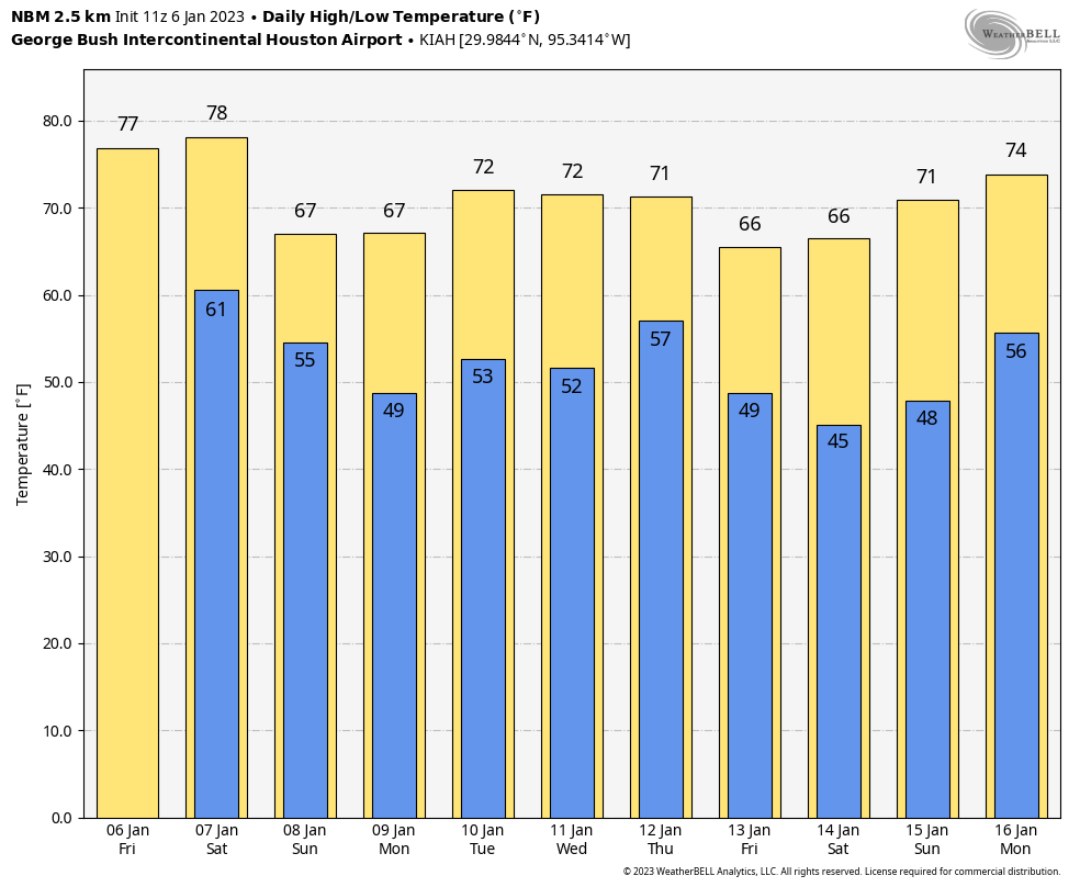
Widespread fog has developed this morning as low temperatures and dewpoints are both about 60 degrees. As the air temperature rises this morning, the fog will dissipate, leaving mostly sunny skies. High temperatures this afternoon will reach the mid-70s, with light southwesterly winds. Low temperatures tonight will drop into the low-60s, and with matching dewpoints we can again expect the development of some fog.

Wednesday

This will be the warmest day of the week, with partly to mostly sunny skies, and highs near 80 degrees for much of the area. Winds will be out of the southwest at 10 to 15 mph. Wednesday night will only see lows drop into the low- to mid-60s.

Thursday

At some point on Thursday morning, probably around sunrise, a cold front will sweep through the Houston region. My sense is that this front will be dry as it moves into Houston, although there is a slight possibility for some storms associated with the front to form north of Houston, particularly north of Highway 105 in Montgomery County. Dewpoints will plunge behind the front, so we’re going to see sunny skies, with highs in the low- to mid-60s, and dry air on Thursday. Winds will be notable out of the north, gusting to perhaps 25 mph. They should dial back some by Thursday night as lows drop into the low 40s.

Low temperatures on Saturday morning will be the coldest of the week. (Weather Bell)

Friday

This will be the chilliest day of the week, with highs struggling to reach 60 degrees despite sunny skies. Winds will be out of the north at around 10 mph. We will see ideal conditions for cooling on Friday night, with Houston dropping to around 40 degrees, and inland areas perhaps into the upper 30s.

Saturday

After a chilly start, temperatures on Saturday will warm into the mid- to upper-60s. You may notice the onshore flow resuming, which will moderate temperatures on Saturday night, dropping only to around 50 degrees. This looks like a fine, fine day for outdoor activities.

Sunday

The second half of the weekend will be warmer. If you’re running the Houston Marathon, start line temperatures will be in the low 50s. However, there are a few things I’m concerned about as a runner. First of all, dewpoints will also be in the 50s, so the lack of appreciably dry air will be noticeable. Winds will also be picking up, gusting out of the south at 15 to 20 mph. Fortunately there’s not too much southward running in the marathon route. Temperatures will also rise pretty quickly, to about 70 degrees by noon, and mid-70s by the afternoon. Bottom line, stay properly hydrated. If you’re a slower runner like me, the second half of the marathon will be fairly warm. Lows on Sunday night will only drop into the mid-60s.
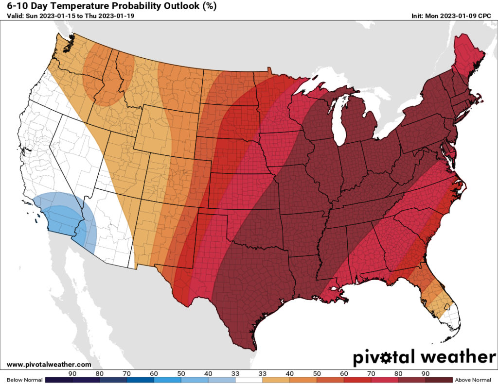
Next week will be considerably warmer than normal for January. (Pivotal Weather)

Next week

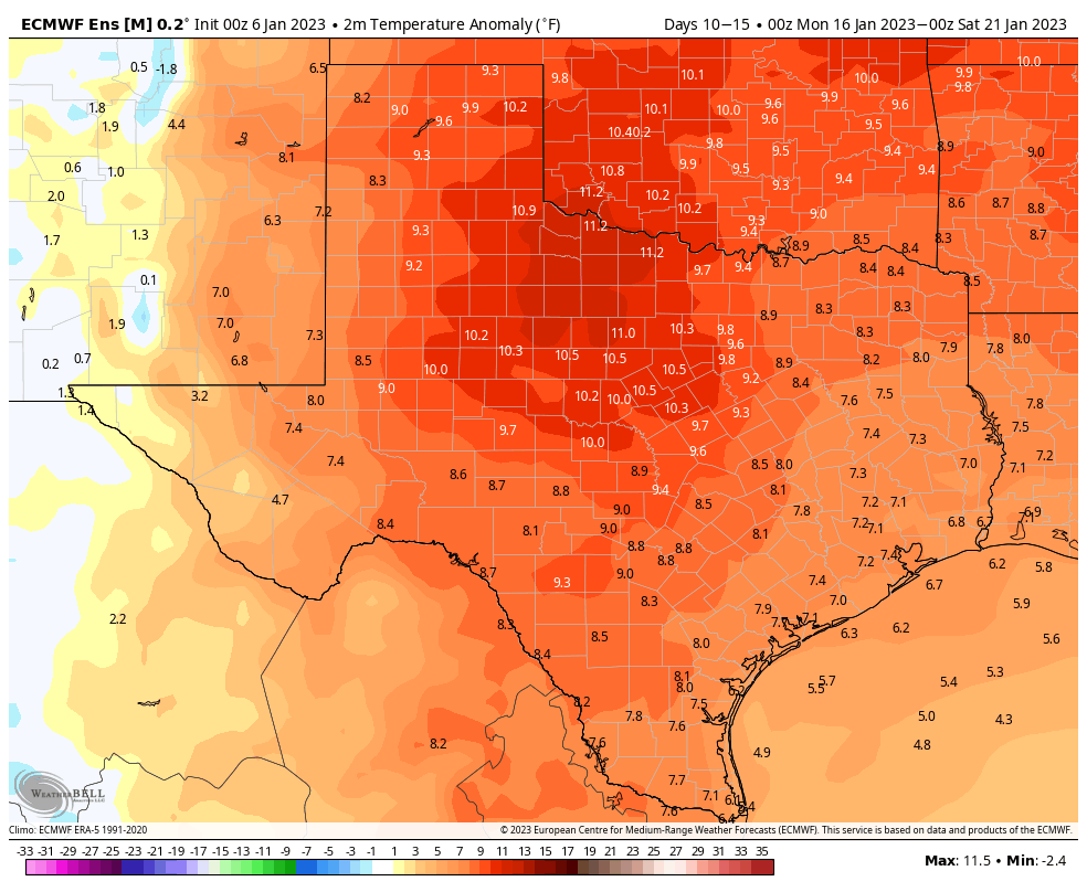
The forecast for next week is warm. We may see a few weaker fronts that will bring some slightly elevated rain chances. Overall, however, we’re looking at highs in the upper 70s and lows in the 50s, probably. It won’t feel like winter, however that does not mean we’re done with the cold. A good friend asked me Monday if winter was over. I replied that it is not, and indeed there are some hints in the models at a colder spell about 10 to 12 days from now. So winter? Yeah it’s probably coming back toward the end of this month.

After a wild weekend, calmer conditions return to Houston this week

Houston just experienced a wild weekend of weather.

On Saturday our region set record high temperatures, with 81 degrees breaking the city’s previous record by 2 degrees, and plenty of sultry humidity. Also, the mosquitoes in my backyard were some of the worst I can ever recall in the Houston region, and I lived through Tropical Storm Allison. Not something I expected to see in January.

The storms on Saturday night were, frankly, more intense than expected. They brought heavy rains—while most of Houston saw 1 to 2 inches, a few pockets of the metro area saw as much as 5 inches—along with very active lightning and hail. There was even a funnel cloud that prompted tornado warnings.

And then things cleared out on Sunday morning. By the afternoon conditions were some of the nicest we will see all year. If you were outside yesterday afternoon, you know. Highs reached about 70 degrees, with sunny skies, dry air, and light northerly winds.

The good news is that we’ve got more pleasant weather on the way for this week.

Pre-sunrise temperatures in Texas on Monday morning are mostly chilly. (Weather Bell)

Monday

Lows have bottomed out near 50 degrees this morning, and while there are some clouds I expect mostly sunny conditions later today. Accordingly, high temperatures should reach the mid- to upper-60s with light easterly winds. Rain chances are about 10 percent. Low temperatures on Monday night will be a few degrees warmer, perhaps dropping into the low 50s for much of the metro area.

Tuesday

As winds turn southerly, look for a partly sunny day on Tuesday with highs in the low 70s and increasing humidity levels. Low temperatures on Tuesday night will only drop into the low 60s, with slightly cooler condition further inland.

Wednesday

This will be the warmest day of the week, with partly sunny skies and highs in the upper 70s with possibly a few readings of 80 degrees around the city. Wednesday night will be warm, with some scattered showers possible late Wednesday night ahead of the next front.

Thursday

The aforementioned front arrives Thursday morning, and it does not look like there will be a line of storms with this one. However, after the front’s passage we will see brisk northerly winds, and as a result the region will be colder for a few days in its wake. Look for sunny skies and highs in the mid-60s on Thursday, with temperatures dropping into the 40s Thursday night.

Lows on Saturday morning should be the coldest of the week. (Weather Bell)

Friday, Saturday, and Sunday

Friday and Saturday will be clear and chilly, with highs in the mid-60s. Temperatures will bottom out on Saturday morning, possibly reaching the upper 30s for inland areas, with most of Houston around 40 degrees or a touch warmer.

If you’re running the Houston Marathon on Sunday morning, the onshore flow will probably have returned. So while start line temperatures may be in the vicinity of 50 degrees, the area will likely warm into the low 70s during the afternoon. Some uncertainty remains this far out, of course, but I feel reasonably confident in warming conditions, as well as very low to non-existent rain chances.

Next week

It looks like the next front will arrive some time on Monday, or so, and this will bring the region’s next real chance of rainfall. The overall details are fuzzy, but I’d guess that most of next week brings highs in the 70s and lows in the 50s.

A mixed January weekend ahead for Houston

We’ve got a little something for almost everyone over the next several days: Cool temps, warm temps, some humidity, and some rain too. A potpourri of mostly low impact weather.

Today

Southeast Texas should be able to squeeze out one more super nice day before clouds arrive this weekend. We may have a bit of a hazy morning with generally poor air quality. There’s even some locally dense fog south and west of Houston this morning. But it will eventually flip to sunshine. We’ll manage to climb into at least the mid-70s with just a slight nudge up in humidity by later today and tonight. Clouds should begin to break out tonight, which will keep temperatures a bit warmer than they have been of late. We’ll bottom out around 60, if not even a little warmer in spots.

Saturday

I would expect partly to mostly cloudy skies tomorrow. If you have morning plans, it should be mostly fine, though a few isolated showers may begin to break out in spots by mid or late morning. If you have afternoon plans, more showers will develop, especially toward the north and west of Houston. So you may dodge raindrops. That should become a little more widespread Saturday evening, along with a slight chance of thunder. Temperatures will jump well into the 70s to near 80 degrees tomorrow before dropping back into the 50s tomorrow night.

Rain totals will average a half to three-quarters of an inch, with some places seeing less and others more tomorrow. (Pivotal Weather)

Rain totals may be held back some due to the scattered nature of the storms, but most of us will get at least some rain, with an average of a half-inch to three-quarters of an inch. Some may see less, and others could see as much as 2 or 3 inches in the most steady storms.

Sunday

Expect the inverse of Saturday: Some morning showers south and east of Houston but then decreasing clouds and increasing sunshine. It will be a good 10 to 15 degrees cooler on Sunday, with highs in the mid-60s.

Early next week

We may be in and out of clouds or some patchy fog on Monday and Tuesday into Wednesday. Other than that, it will be generally fair and mild. We think. With the weekend front sort of parked offshore, some coastal areas may see a few showers. Either way, it looks like a mostly quiet period, with increasing temperatures. We’ll warm from the mid to upper 60s Monday into the mid-70s by Wednesday, with morning lows generally in the 50s or upper-40s. Not bad for January.

Late next week and beyond

The next front in line is penciled in for Thursday. That should come with some showers or a thunderstorm, but it’s still a bit soon to speculate on how widespread any rain will be. More importantly, that front ushers in what should be our coolest air mass of 2023, with lows in the 40s by Friday, Saturday, and probably Sunday.

Behind Thursday’s front, we should see rather cool weather. The initial read on the Houston Marathon remains positive. (Weather Bell)

Our outlook for the Houston Marathon has held fairly steady this week. Today it looks like morning 40s, quickly rising into the 50s and low-60s with light winds and dry weather. A lot can change in 9 days, but right now, we’re sitting in a decent spot.

Days 10-15 look quite warm, with both the Euro (shown here) and GFS indicating above normal temperatures after next Sunday. (Weather Bell)

It appears that any cool weather will be short-lived however, as we expect a pretty significant warm up after Sunday next weekend. We have pretty healthy model agreement on temperatures warming deep into the 70s as the weather pattern amplifies warmer over us for several days the week of the 16th.

One more day of spectacular weather before Houston’s forecast turns cloudier this weekend

Wednesday was an A+ weather day in Houston, and Mother Nature is going to get high marks again today as high pressure holds sway over our region. The forecast turns rainy by this weekend, with a healthy dose of clouds and rain chances through Monday before sunnier weather returns next week. Temperatures will remain fairly mild for the foreseeable future.

Thursday morning temperatures across much of Texas are rather brisk. (Weather Bell)

Thursday

With high pressure still in place, we’ll see sunny skies today with highs of around 70 degrees across the metro area. However this pattern starts to change later this afternoon or evening, as winds shift from the northwest to southeast. Due to this more southerly flow look for lows on Thursday night to be a few degrees warmer, bottoming out in the low 50s in Houston.

Friday

This will be another sunny day, but highs will climb into the mid-70s as a more pronounced southerly flow resumes. Look for fairly robust southeasterly winds, gusting to perhaps 20 mph. This will start to pump up atmospheric moisture levels. Low temperatures on Friday night will only drop to around 60 degrees in Houston.

Saturday

The first half of the weekend will be quite warm, with highs in the upper 70s. Local temperatures will depend on how much sunshine you see, as at least partly sunny skies are possible during the daytime. Some scattered showers will be possible during the day, but the better chances will hold off until Saturday night into Sunday, as a cold front slogs toward the area. Look for accumulations of 0.5 to 1.5 inches of rain for most into Sunday morning.

High temperature forecast for Saturday. (Weather Bell)

Sunday

For inland areas, rain chances will be fairly low after Sunday morning, with mostly cloudy skies and highs in the 60s. Some showers may linger closer to the coast however, as the front may stall just offshore. Hopefully Matt will be able to fine tune the weekend forecast a little bit in tomorrow’s post. Lows on Sunday night should drop into the mid-50s in Houston.

Next week

A second round of showers is possible on Monday as an atmospheric disturbance moves through, but I’m not expecting too much in terms of precipitation from this system. After that, much of the rest of next week looks partly to mostly sunny, with highs in the low 70s, and lows in the 50s. It looks like a stronger front may arrive by Thursday or Friday to knock overnight lows into the 40s for a bit. Rain chances look low for the weekend of the Houston Marathon to go along with cooler temperatures, but that remains subject to change this far out.

Paperback copy of Liftoff

This week the publisher of my book about the origins of SpaceX, titled Liftoff, released a paperback copy for the first time. I am happy to sign and personalize copies of this new paperback edition of Liftoff if you order a copy today from Houston-based Blue Willow Bookshop. You can find instructions for doing so here, if you are interested. Thanks!