In about a week, Houston should finally get its first true taste of autumn

We have two problems to solve right now in Houston. There’s the abnormally hot weather (September is on pace to obliterate the previous warmest September on record), although I’m sure temperatures are now such that some of you are okay with things. There is also the drought. We’ve been nibbling away at that over the last 2 weeks or so with some daily showers and storms popping up across the area (including a spectacularly photogenic one yesterday).
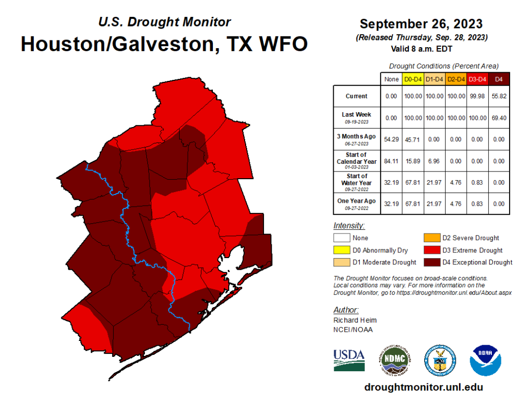
Believe it or not, the drought has actually improved week over week in Houston, albeit just a teensy bit. (US Drought Monitor)

Yes, we’ve knocked back the extent of exceptional drought from 76 percent coverage at its worst to 56 percent today, but that’s the hydrologic equivalent of getting a gratuitously indulgent slice of chocolate cake, having one small bite, and calling it a day. There is still work to be done.

More likely will be a legitimate cooldown next week, although that could come with some rain too. Eric said yesterday that if it does not happen, it’s my fault. I could not agree more. Let’s dive in.

Today through Monday

This forecast is pretty basic. Expect sun and clouds each day with highs in the mid, perhaps upper-90s in a few spots (near 90 or so at the coast), with lows in the mid-70s.
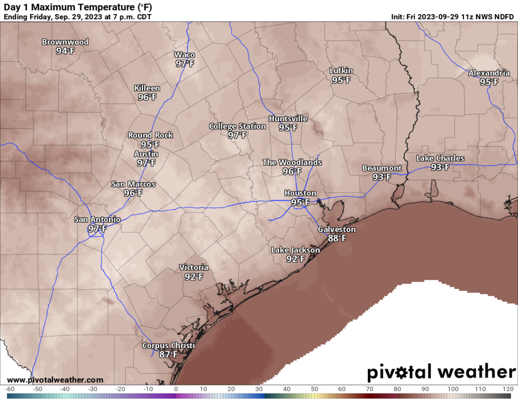
Sweat it out today and tomorrow with inland highs easily in the mid-90s, if not upper-90s in spots. (Pivotal Weather)

Each day will carry a very, very low chance of showers north of I-10. Better (but not high) chances will exist south of I-10, especially near the coast, down toward Matagorda Bay, and into the Victoria Crossroads. Most places won’t get wet, but those that do could see some locally heavy, brief downpours.

Tuesday and Wednesday

As moisture increases and the “trigger” for showers edges a little closer to our area, we could see slightly better chances of isolated to scattered showers and storms here. We’ll probably be talking about highs in the low to mid-90s, with lows still in the 70s.

Cold front!!!!

While models differ on the exact timing of things, it appears that sometime between Thursday and Saturday our first bonafide cold front of the season will finally push through the area.
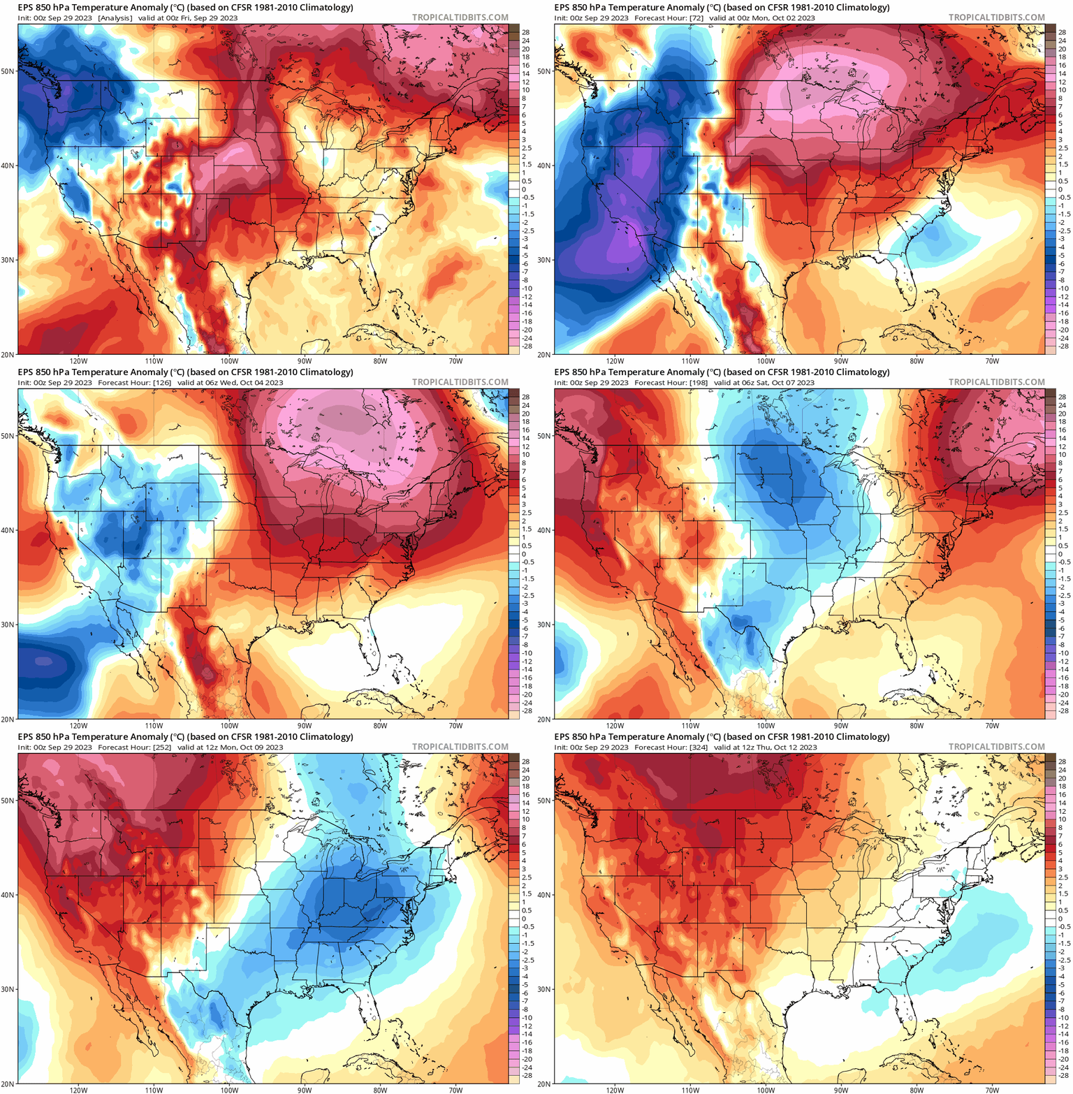
The European ensemble forecast of mid-level temperature anomalies over the next 13 or 14 days shows how the warm pattern finally breaks down for a spell late next week and weekend. (Tropical Tidbits)

It should hopefully deliver some showers and storms, followed by cooler and much less humid air. We’re probably looking at highs in the 80s and lows in the 60s along with comfortable humidity most days beyond Friday if all goes according to plan. Fingers crossed. We’ll have an update on this for you Monday.

Fall’s first real front may finally be on the horizon, and it’s coming very late this year

Good morning. Houston faces at least another week of very warm, late summer weather with fairly low rain chances. However, the big news is that we’re finally starting to see the likelihood of the season’s first real cool front on the horizon. First, the caveats. It’s still about 10 days out, so a lot can happen. Our ability to forecast weather accurately only goes out to 7 to 10 days. However, the signal for this front (see below) is fairly strong. I’ll put it this way: I think the odds of seeing a pretty decent front are better than 50-50 at this point.

Another reason for some hope: It’s time. If we define a front as the fall season’s first day with a temperature of 65 degrees or below, Houston typically sees its first front sometime between the first week of September, and the first week of October. In records dating to 1889, there have been just 14 instances in which the season’s first front arrived on or after October 1, so about a 10 percent chance in any given year. The latest of these came in 1904, when the front was delayed until October 13. This year is going to be close to that, but right now we’re on track for the period from October 7 to 10—so just in time.

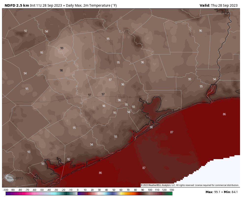
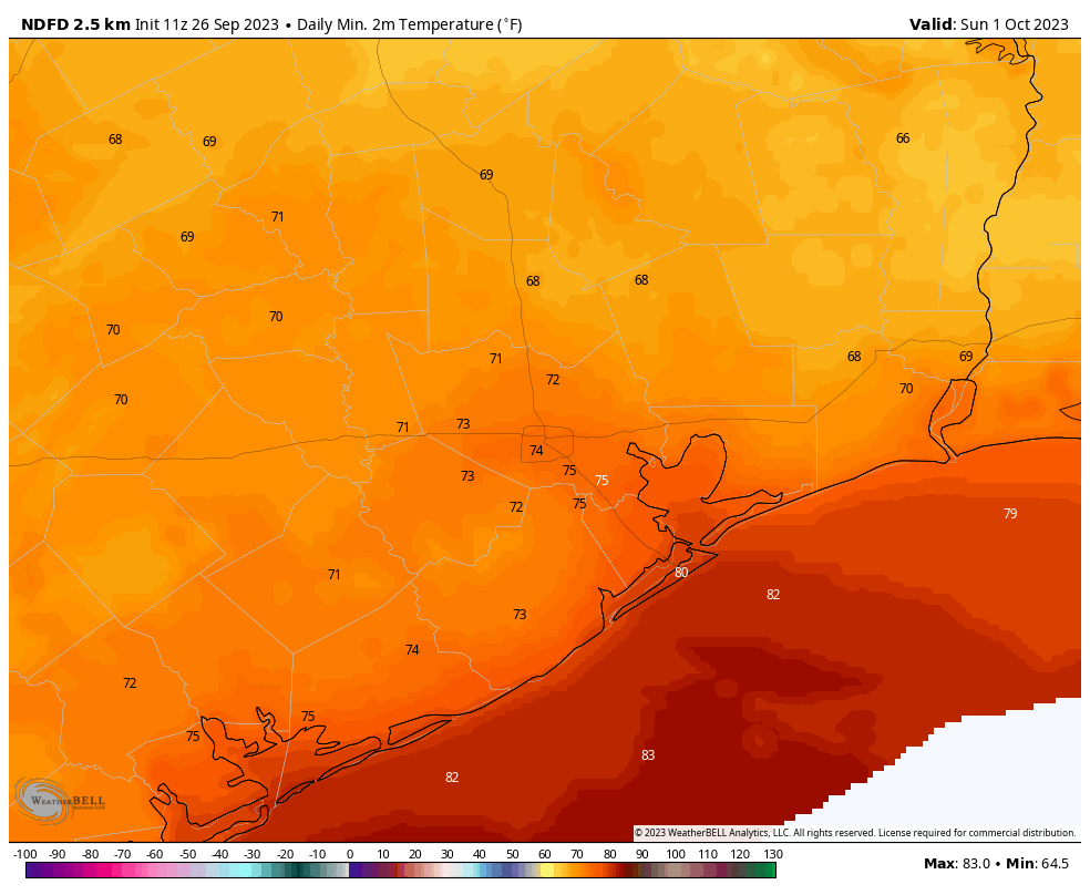
Today will be unseasonably hot across the Houston metro area. (Weather Bell)

Thursday

Fall will feel a long ways away today, however. As high pressure more or less takes control of our weather, we’re going to continue to see high temperatures generally in the mid-90s across the region today, and for awhile. Yesterday we saw some fairly strong thunderstorms develop near Katy, and some isolated or scattered showers and thunderstorms will be possible again this afternoon or early evening. The most likely areas will be close to the coast. Skies will otherwise be mostly sunny, with light easterly winds. Lows tonight will drop into the mid-70s.

Friday

Did you like Thursday’s weather? Good, because Friday is pretty much the same.

Saturday and Sunday

We’re not going to see much change in our weather this weekend, with mostly sunny skies and highs in the mid-90s. Rain chances will, again, be on the order of 20 percent, with the highest odds near the coast. However, by Saturday the flow will turn a bit more northeasterly, and this should bring some slightly drier air into the picture. It won’t be much, but by Sunday morning it should start to may thinks feel a bit more comfortable.

Both the GFS model (left) and European model have a fairly strong signal for a front in about 10 days. Use the slider to compare. (Weather Bell)

Next week

We’re going to remain warm for most of next week, with highs likely in the vicinity of the mid-90s. However, the overall pattern may favor the influx of some tropical moisture, and this may bring some slightly better rain chances into the forecast by Wednesday, or so. By next weekend is when we’ll be looking for a cold front to arrive. I kind of hate to write about this, because I don’t want to be accused of being a tease. But the reality is that this is the strongest signal we’ve seen for fall’s first front, and the upper air pattern does appear to support its passage. So am I guaranteeing a front? No. I am rather hopeful? Yes. If it doesn’t come, can we all simply agree to blame Matt?

Late summer heat to hang around for awhile, although some drier air will help a bit

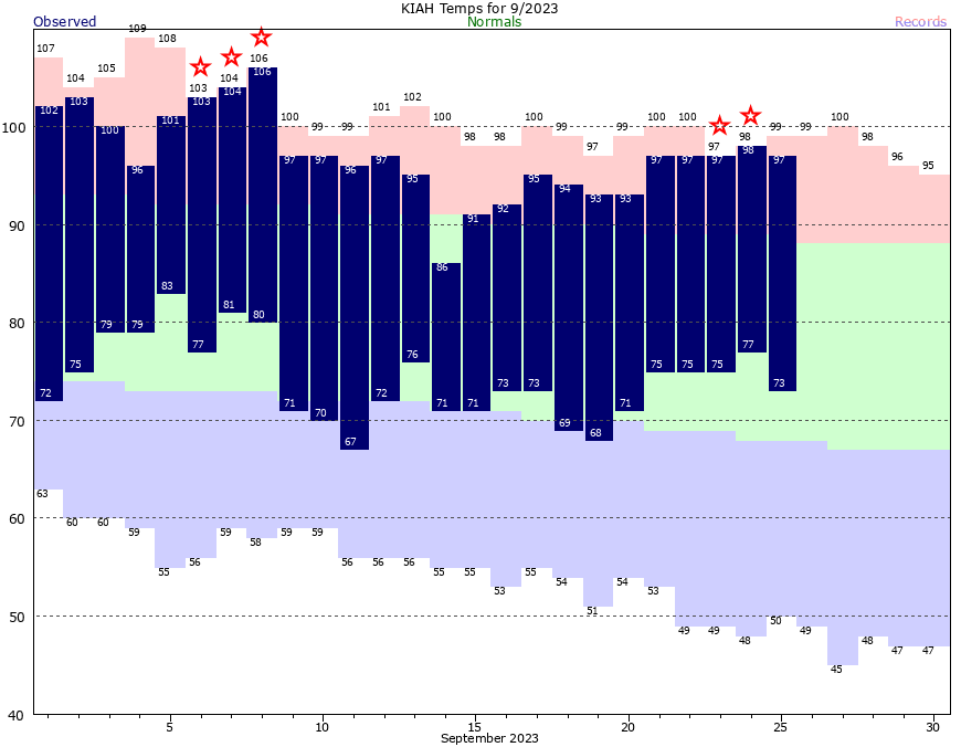
Good morning. Don’t look now, but Houston’s exceptionally hot summer continues. September is not yet over, but this month is on pace to—you guessed it—become the warmest September on record in Houston. The month’s average temperature is 85.6 degrees so far, which would smash the city’s record for September heat. Unfortunately, as you’ll see in the forecast below, our above-normal warmth will continue for some time.

This lingering heat has had all manner of negative effects, including on electricity bills for cooling your home. As part of our partnership with Reliant, I recently sat down with Reliant Energy’s Hosea James to discuss the incredible heat we experienced in the 2023 summer season, how that impacts customer electricity bills, and resources for assistance. You can watch the video here.

Houston has tied or broken five high temperature records this month. (National Weather Service)

Wednesday

With a nearly stationary boundary offshore, Houston will see another day during which at least some scattered showers and a few thunderstorms should pop up during the afternoon and evening hours. Chances will be best closer to the coast, so perhaps 30 percent for areas south of Interstate 10, with a lesser likelihood for inland areas. High temperatures today should climb into the low to mid-90s, with mostly sunny skies and light northeasterly winds. Low temperatures tonight will drop into the mid-70s.

Thursday

Expect day a lot like Wednesday in terms of the overall setup, but rain chances will likely be a little bit less. Highs again will be in the low- to mid-90s.

Friday, Saturday, and Sunday

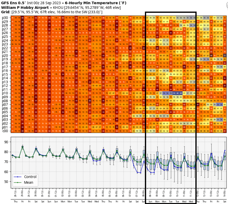
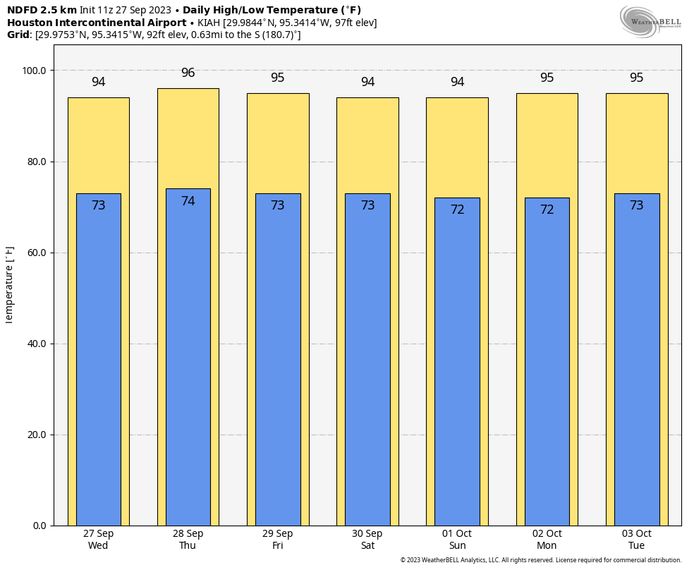
The pattern looks incredibly consistent over the weekend, with high pressure more or less in control of our weather. We’re going to see continued days with highs in the low- to mid-90s, sunny skies, and generally light winds. The influx of some slightly drier air will have several effects. It should shut down any meaningful rain chances, but it also will slightly lower the overall humidity levels. So the heat will feel a little bit more comfortable. (Emphasis on a little bit). Overnight lows will be in the lower 70s for most of the area.

Don’t expect much variability in temperatures for awhile. (Weather Bell)

Next week

There does not appear to be much change in this pattern for the first half of next week. After that? Well, the first opportunity for a cool front comes about 10 days from now, but again, it’s far from certain. It is fairly depressing to write this, so I can’t imagine what you’re thinking, but it does look like “late summer” is going to hold on for awhile, at least into the first week of October.

A note from Reliant

As Eric diligently reported, summer brought intense, unrelenting heat in Southeast Texas this year. While we may be out of this stretch of extraordinary temperatures, energy bills covering that time when ACs were working harder than ever are starting to arrive. Reliant prioritizes giving everyone access to the electricity they need to live comfortably. Anyone concerned about summer bills or needing payment assistance is encouraged to contact Reliant. We are here to help with agents available 24/7 via live phone support, online chat, or on the Reliant app.

With the usual caveats, I’m happy to say that the 2023 Texas hurricane season is over

This has been an unprecedented year, heat-wise, so it’s difficult to rely too much on past climate and weather norms. However, we have reached the point of the year after which it is extremely unlikely for a hurricane to strike the state of Texas. The historical odds of doing so after the date of September 24 are approximately 1-in-50.

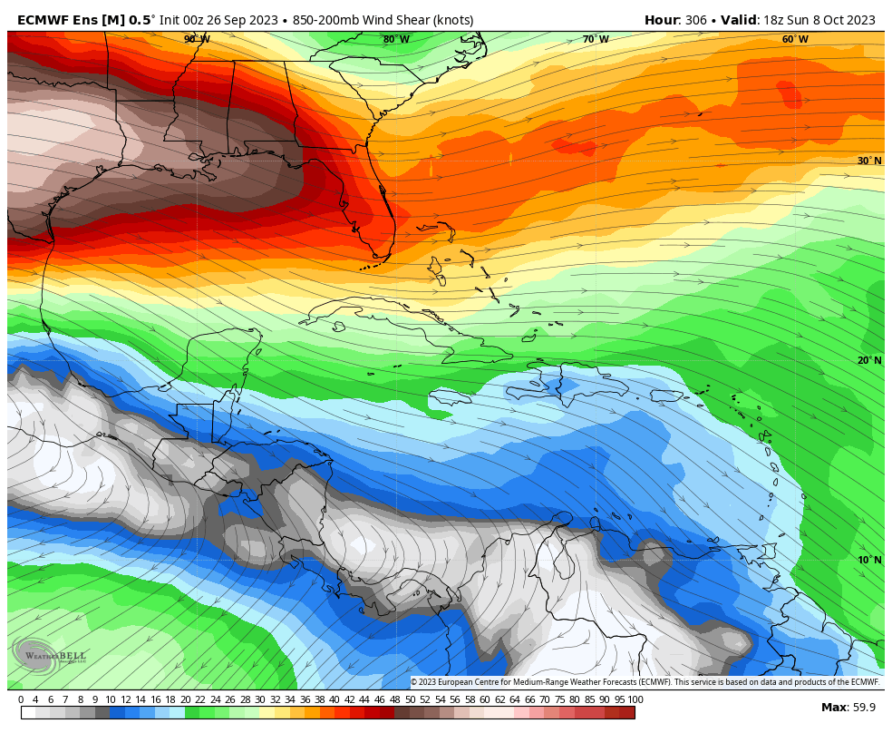
Despite the fact that the Gulf of Mexico remains toasty warm, if there ever were a year to call the season in late September for Texas, this is the season. Wind shear has been exceptionally high over the last few weeks, and it is showing no signs of abating in the near future. And the overall pattern does not appear to support the movement of tropical systems into the Western Gulf of Mexico toward Texas. The bottom line is that history says we’re done, and the current setup says we’re done. Never say never, but we’re probably done.

Even as far as October 8, the European ensemble model is forecast wind shear conditions very hostile to tropical systems over the northern and Western Gulf of Mexico. (Weather Bell)

That is not to say that we still cannot see a tropical storm or a disturbance that brings us rain. That can happen in October, and has in the past. But these are mostly moisture events rather than serious wind or surge events. This also says nothing about the hurricane odds for Louisiana and points east. It remains an active Atlantic season, which we’re tracking for you on The Eyewall. So my advice is this: Although the Atlantic hurricane season will continue for another couple of months, you can breathe a little easier this morning if you live in Texas.

Tuesday

Houston saw some solid, widespread showers and thunderstorms on Monday. If you got the rain you needed, that’s great. If you didn’t, well, that’s probably the end of the widespread showers for awhile. We’ll still have some spotty rain chances going forward, but nothing like Monday. For areas south of Interstate 10, chances today are probably about 30 percent, and for areas north they’re much closer to zero percent as the weak front that drove Monday’s storms has moved offshore.

Skies today will be mostly sunny, with a light northeast wind, and highs of around 90 degrees or slightly above. Our air is slightly drier, and this should help low temperatures drop into the low 70s for much of the city, with upper 60s possible for far inland areas.

Wednesday

Another day a lot like Tuesday, with coastal areas seeing a chance of rain, and highs generally in the low 90s.

Thursday and Friday

The overall pattern more or less continues, with highs in the low 90s and sunny skies. Nights, generally, will drop into the mid-70s. Rain chances will continue to hover in the 10 to 20 percent range, so unlikely for most.

By Sunday morning, some inland areas should start to see low temperatures in the upper 60s. (Weather Bell)

Saturday and Sunday

The upper atmosphere will support the flow of some modestly drier air starting this weekend, so that will allow daytime temperatures to rise a bit. But this will also support more rapid cooling in the evenings, and somewhat lower humidity. Look for highs in the low- to mid-90s this weekend, with sunny skies, and lows in the low 70s except near the coast.

Next week

The overall flow of somewhat drier air should continue next week, with highs generally in the low 90s, and nighttime temperatures in the more seasonable low 70s. It won’t be fall, but it’s something a bit nicer than summer. Truth be told, after the summer we experienced, it should feel pretty good outside. There are some hints of fall’s first real front about 10 days from now, but they’re not strong enough for me to have any confidence. We’ll see.