Summary: Houston will experience some fairly chilly weather for the next 24 hours, with highs today in the 50s and lows in the 40s overnight. We may also see some light showers on top of that. The weekend will warm nicely, with plenty of sunshine on Saturday. Our best chance at widespread rain, with decent accumulations, will come next Monday.
Low temperature forecast for Friday morning. (Weather Bell)
Thursday
We’re starting out today with temperatures of about 50 degrees, and due to a preponderance of clouds we likely aren’t going to rise much higher. Temperatures this afternoon should peak in the upper-50s across the Houston region and now that we’re at the end of February, I can’t help but wonder when that will happen again. Probably not for many months. (Houston’s first high in the 50s last fall came on October 30).
In any case it’s going to be cloudy and chilly. The atmosphere is pretty dried out right now, but that will change today as a more southerly flow takes hold just above the surface. With more moisture in the atmosphere we’ll see an increasing chance of very light rain this afternoon and evening, although accumulations during the overnight hours will be measured in hundredths of an inch for most.
Rodeo forecast
Bring a jacket, maybe. Temperatures will be in the mid-50s this afternoon as you venture out to the rodeo, and as mentioned there will be a chance of light rain, perhaps about 40 percent or so. Winds, from the northeast at the surface, will be fairly light. Things won’t change much after the concert, with temperatures in the low-50s, more clouds, and a continuing chance of light rain.
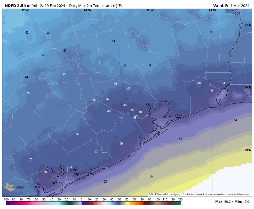
Friday
This will be our coldest morning for some time as much of Houston falls into the upper 40s. We’ll see some clearing skies later on Friday, and in conjunction with a more easterly flow this will help temperatures warm to about 70 degrees, perhaps a tick warmer. Lows on Friday night will drop into the 50s.
Saturday and Sunday
The weekend still looks good to go for outdoor activities. Saturday looks quite nice with mostly sunny skies and highs in the upper 70s to 80 degrees. Lows will drop to around 60 degrees. Sunday will see more clouds, and a bit muggier air, as highs reach about 80 degrees. There’s a slight chance of some showers later on Sunday but I think they’re likely to hold off until Monday. Lows on Sunday night will only drop into the 60s.
NOAA rain accumulation forecast for now through next Tuesday. (Weather Bell)
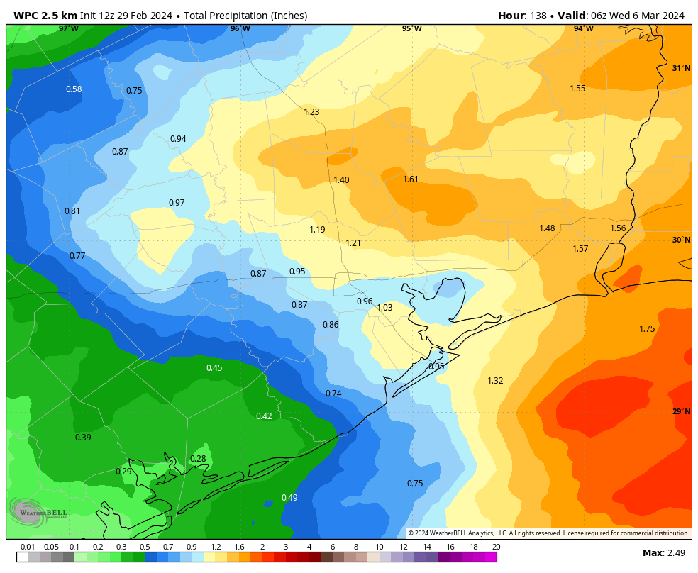
Next week
The details are still uncertain, but it looks as though a front will move into the vicinity of Houston on Monday and stall out. This will lead to a healthy chance of rain showers on Monday and Monday night, possibly stretching into Tuesday morning. I think most of the area probably will see around 1 inch of rain, give or take. After that temperatures will depend on the front, but since it now seems likely to stall, I bet we see highs of around 80 degrees, with lows in the 60s, for most of next week. Conditions may turn a bit cooler toward next weekend.
Wild weather
In some parts of Texas, and around the country, there’s been some pretty wild weather of late. We’ve got the rundown on wildfires in the Texas panhandle, tornadoes in Michigan, and more in The Eyewall.
Summary: A front will blow through Houston this morning to bring a surge of much drier air into the region. This will result in a couple of cooler nights. We’ll also see the return of some light rain showers on Thursday night, but the weekend should yield some sunshine.
Lows on Wednesday night will be the coldest of the week for some locations. (Weather Bell)
Wednesday
A cold front will push into Houston this morning to displace the muggy air mass overhead. Temperatures will drop only a few degrees initially, but dewpoints will fall off a cliff. Skies will remain mostly cloudy. We should see wind gusts jump up above 30 mph for a few hours this afternoon as this drier air blows in from the north. In short, more winter-like weather will come raging back into Houston for a little while.
Rodeo forecast
Winds will begin slackening late this afternoon and evening, but I still expect gusts above 20 to 25 mph as you’re heading into the rodeo. Temperatures before the show will be in the 60s, dropping into the 50s after the show. With the breeze, it will definitely feel a bit chilly outside. Overnight lows will eventually drop to around 50 degrees by Thursday morning, with cooler conditions for outlying areas.
Thursday
This will be the one cold day this week. I’m not sure highs will get out of the 50s, with mostly cloudy skies. Unlike a lot of fronts we see in Houston, this one is not going to be followed by a lot of sunshine. Rather, pretty quickly the flow is going to turn northeasterly, and in concert with some weak atmospheric disturbances it’s possible that we see some very light showers later on Thursday afternoon or Thursday night. into Friday morning. Lows should drop to around 50 overnight.
Friday
This will be a transition day back to warmer weather. After light showers end during the morning hours we should actually see a bit of sunshine later in the day, with highs in the upper 60s to 70 degrees. Winds will be fairly light, from the northeast. With a warmer flow in place, lows on Friday night likely will only drop into the low 60s.
Saturday and Sunday
The weekend looks fine. We should see partly sunny skies and highs in the upper 70s to 80 degrees. Humidity levels will be moderate, but not oppressive. Overnight temperatures will be mild. I can’t entirely rule out a chance of showers later on Sunday or Sunday evening, but I think these will hold off until Monday.
Rain accumulation forecast for now through next Tuesday. (Weather Bell)
Next week
Next week’s forecast is filled with a whole lot of “I don’t know.” The uncertainty is due to the approach of a cold front by around Tuesday-ish, and a lack of clarity on whether it pushes all the way through Houston. The bottom line is that I do think we’ll see elevated rain chances on Monday and Tuesday, with accumulations of perhaps half an inch, give or take. But as for temperatures, who knows. We’ll probably be somewhere in the 70s during the daytime, but the nights will depend on the progression of the front.
Summary: Houston will see one more warm day before a front arrives on Wednesday to cool us down for a couple of days. The first half of the weekend looks rather pleasant, but we’re keeping our eye on the potential for the return of some decent rainfall next week.
It’s a very mild morning across much of Texas. (Weather Bell)
Before the forecast, two programming notes. First of all, if you missed it, we did our first monthly Q&A feature on Monday, and we hope to do these regularly going forward. Secondly, the Houston Livestock Show and Rodeo begins today, and it’s an iconic event for our region attended by more than 2 million people. Accordingly, we’re going to offer daily forecasts, brought to you by our sponsor Reliant. we’ll share what you need to know about the expected weather before and after the rodeo and concert every day. Additionally, make sure to scroll to the bottom of this post and read Reliant’s fun Rodeo experiences (I’m definitely stopping by the Space City Cowboy photo op!)
Tuesday
Today will be another warm one, with highs likely topping out in the low 80s across much of the region. There may be a bit more sunshine than on Monday, but I still expect more clouds than not. Winds will be noticeable from the south, gusting up to 30 mph at times.
Rodeo forecast
If you’re heading out to the Blake Shelton concert this evening, hold on to your hat. Actually, the winds should be backing off a little bit later this evening and afternoon, but I just wanted to say ‘hold on to your hat.’ Temperatures will be mild this evening, perhaps about 70 degrees, with moderate humidity. Expect cloudy skies. Temperatures will only be a few degrees cooler after the show, heading down to overnight lows in the mid-60s tonight. Despite the clouds I don’t expect any rain showers today or tonight.
Wednesday
After a warm night a cold front will sweep through Houston on Wednesday morning, and the change will be pretty immediate. I’d expect the front to be near areas like Katy and The Woodlands around sunrise or an hour or two after, and be off the coast by or before noon. In the wake of the front we’ll see gusty northerly winds, mostly cloudy skies, and temperatures in the 60s with much drier air. Lows on Wednesday night will drop down to around 50 degrees in Houston.
Thursday morning will be the coldest one of the week. (Weather Bell)
Thursday
Here the brief spell of ‘winter’ I mentioned in the post headline. Skies will be cloudy on Thursday, with highs likely only peaking in the upper 50s to lower 60s. Winds will slow down. The air is going to be rather dry, with low dewpoints. However by later Thursday afternoon we’ll see winds turn to come from the south, and this will mark the beginning of an onshore flow. Lows on Thursday night will drop into the low 50s for most away from the coast.
Friday
We’ll see some decent rain chances late Thursday night into Friday morning, but accumulations look rather slight, likely in the hundredths of an inch. Skies, otherwise, will be mostly cloudy with highs in the low- to mid-70s. Lows on Friday night will probably drop down to around 60 degrees.
Saturday and Sunday
The first half of the weekend looks pretty good for outdoor plans. We’ll see highs of around 80 degrees with partly sunny skies. Rain chances look to be close to nil. Lows Saturday night will be mild, in the low 60s.
Sunday will bring more clouds, and a slight chance of rain. Still, anything that falls should be very light. Highs will again be around 80 degrees.
Next week
The forecast for next week is somewhat in flux. However, in general, we can expect warm conditions on Monday and probably Tuesday. At some point a front is going to move toward our area and help generate conditions for rainfall. This will probably our best chance at some decent accumulations of rainfall in a while. This front will be followed by some cooler weather for a couple of days. So, basically, more spring is on the way.
A message from Reliant
This isn’t our first rodeo, and, at Reliant, we’re here for a rootin’ tootin’ time at the Houston Livestock Show and Rodeo, now open today through March 17. Here are a few fun places to stop by:
Saddle up in Space City at Reliant’s new photo op for Rodeo fans to enjoy, located in the lobby of NRG Center at Hall C. A tip of the cap to Houston’s ‘Space City’ roots, grab your partner and take a trip to the moon in this interactive photo op that makes you and your posse feel like a Space City Cowboy.
Stop by the Reliant Ranch in NRG Plaza for an interactive experience for rodeo-goers of all ages. Two step on over to enjoy festive games like Get Your Ducks in a Row-deo, Boot Toss, Ring Toss, and a Souvenir Penny Press. And don’t forget to say howdy to our pal Hugo, Reliant’s friendly brand ambassador!
Hold your horses, we can’t forget the iconic Reliant Big Boot! Standing at 25-feet-tall, this staple of the Rodeo provides visitors with another great Instagram-worthy moment. Grab the whole crew and giddy on up before you head to the concert, carnival, or let’s face it… the Champion Wine Garden!
While you’re busy snapping pics as a Space City Cowboy or over at the Reliant Big Boot, we also have you covered with free charging stations throughout NRG Park, so you can stay powered up and present! With a valid email and credit card ($1 hold), rodeo-goers can borrow a power pack and return them at any charging station once they are done.
One of the best things about Space City Weather is the people who read it. Anyone who writes regularly wants to feel like the audience is paying attention – and it’s even sweeter when they’re talking back. SCW is more than just Eric and Matt: It’s you, too.
And you have questions. Lots of them. We enjoy turning your queries into posts, which happens a lot. Now, it’s going to happen more. We’re starting a monthly SCW Q&A feature, in which Eric and Matt will tackle a handful of questions you’ve asked them recently.
Got a question of you want answered? Leave it as a comment here or on one of our many social channels (we’re everywhere!), or hit the Feedback button on the blog’s home page.
Q. Do you think we’ve seen the last chance of frost? I’m itching to get plants in the ground.
A. We received a couple of questions along these lines. We are now past the “average” date of the final freeze for pretty much all of the Houston metro region, except for a few outlying areas like Conroe and Montgomery. So historically the city’s odds of seeing another freeze are below 50 percent.
But I think they’re far lower than this. We’ve clearly entered a more spring-like pattern, and there is no sign of a super-strong front in the next 10 to 14 days. So I’d say our chances of seeing another freeze in the Houston area this season are 10 percent, or less. It could happen. The city has recorded freezes in early April before. But it’s very unlikely.
–Eric
Q. When do you expect that the yellow pollen will be back in Houston again? Thanks!
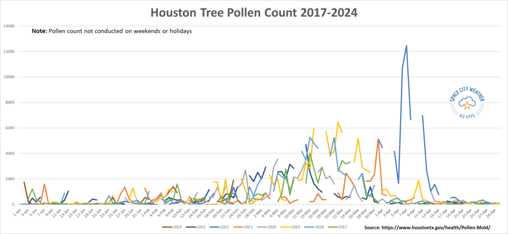
A. It’s baaaaaack! Allergy season is now in full swing. Usually, we’ll see little bumps in pollen through January and February as we get periodic milder weather. But we never see the full force of pollen arrive until usually the last week of February. It appears that began last Friday. In fact, if you look historically, you can see this in the City of Houston’s tree pollen count. The chart’s a bit messy because data is not taken on weekends or holidays. But you can see the general trend.
The daily tree pollen count in Houston from 2017 through last week shows that allergy season typically peaks around mid-March here. 2022 was a notable exception with a massive peak in late March.
Since 2017, Houston’s peak pollen day has occurred in March, varying between the 6th and the 31st and averaging around St. Patrick’s Day. Pollen typically builds in the first half of March, peaks, and then slowly tails off before a more dramatic drop heading into April. Notice how on the chart above 2021 stands out for how short pollen season was, thanks in part to the mid-February freeze. With a potentially extended spring this year, we probably won’t get so lucky. Whatever the case, the next three to five weeks will probably be rough for those with pollen allergies.
–Matt
Q. You’ve talked about how it’s silly to predict hurricanes too early. But at what point does a season prediction start to become credible, in terms of timing?
A. This is a really good question. Seasonal forecasting for hurricanes is a challenge, whether you do it in January, March or May. This is part of my day job in the energy industry, and it remains the most elusive in terms of consistency, particularly when you get into other variables like temperature or rainfall for a season. But from the standpoint of hurricanes, seasonal forecasting is actually not half bad when you begin to see outlooks emerge in March. Colorado State University issues one of the most publicized hurricane outlooks, and this year’s first iteration comes out on April 4th. Anything prior to that can be hit or miss.
Raw modeling of hurricane season forecasts is occasionally good, occasionally bad. For humans, trying to predict El Niño vs. La Niña and the amplitude can be a challenge this time of year because of the inherent “spring predictability barrier.” That’s one of our best signals for determining directionality of a hurricane season (busier or quieter). But some years are easier than others. The current thought among most meteorologists I know and follow, as well as my own independent thinking, is that we are almost certainly heading into a La Niña this summer. That, combined with continued exceptionally warm oceans globally (a global marine heat wave) seems to imply that virtually no one should be forecasting a quiet hurricane season this year. We wrote about this in detail last week at our companion site The Eyewall.
But as far as firm concrete numbers? Late March and early April offers a viable first guess, with some adjustments in May and even June. That said, what no one is really, consistently good at on a seasonal scale is predicting where storms will go. So regardless of forecasts, it’s important to remember to prepare for every hurricane season as if it will be the one that impacts you.
–Matt
Q. I have a question regarding how clear Houston appears following a cold front. I imagine it’s because the wind blows the smog and pollution away. But what’s the science behind that? Does it also have something to do with our humid climate?
Well, you have pretty much answered your own question!
First let’s characterize the haze that typically makes for less clear air. Haze is caused when sunlight encounters tiny pollution particles in the air. Some of this light is absorbed by particles, and some is scattered away before it reaches you. More pollutants mean more absorption and scattering of light. In Houston we have plenty of pollutants in the air, which increases the likelihood of haze. But weather plays a role as well.
Fronts typically bring blustery conditions, and these winds clear out air pollution at the surface. In addition, warmer air in Houston tends to be more humid. So think about a warm, summer day in Houston: It’s humid, winds are typically light and its partly to mostly sunny. These are ideal conditions for the formation of haze. Conditions in the wake of a good front: cooler and drier air, and windy conditions, are kryptonite for haze.
–Eric
Haze is caused when sunlight encounters tiny pollution particles in the air. (US EPA)
Q. I love the site and love the new(-ish?) logo! Any chance you’ll get that on a coffee cup at some point?
A. I’m glad you like the new design! It was time for a refresh. The original design, depicting the space shuttle carrier aircraft flying over the city of Houston, dates to October 2015. At the time I was in a rush to create the site in a couple of hours. I grabbed the image because it was a free NASA photo and it captured both the elements of “Space City” and “Weather.” But it wasn’t professionally done. I love the new look, and especially because it features the International Space Station, which is flown right here from Houston.
As for coffee cups, that’s a great suggestion. We’ll be sure and add those to our annual fundraiser. That takes place in November when we encourage people to buy merchandise and donate to support the website and our app.