Houston has experienced another very warm morning, with lows generally in the lower 80s. The all-time record “high minimum” temperature for the region is 83 degrees—set several times in 1980 and 2010—and the mercury at Bush Intercontinental Airport will only fall 1 or 2 degrees below that today. Part of the reason for these warm, pre-sunrise temperatures is a broken cloud layer. This should also help to moderate temperatures slightly later today.
Tuesday
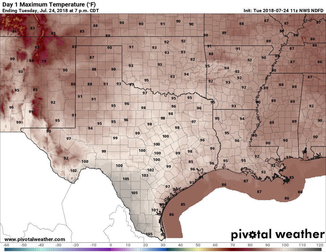
The clouds are harbingers of a weak front sliding down through the area, and which should move off the coast later today or this evening. Increased clouds today should lead to slightly cooler temperatures, with highs generally in the mid-90s.
Later this afternoon a few isolated to scattered showers are possible closer to the coast, south of Interstate 10 and southwest of Houston. If you get rain, count yourself as lucky.

Wednesday, Thursday, Friday, and Saturday
After today, not much will change weather-wise for the rest of the week. We’re going to see very hot days, with high temperatures in the upper 90s. and warm nights, with lows in the upper 70s. The heat doesn’t seem likely to be quite so extreme as this past weekend, but it will be plenty hot, with near-zero rain chances.
Sunday and beyond
At some point next week it appears increasingly likely that high pressure will be edged out of the area, allowing for some upper-level systems to bring more clouds, some rain chances, and probably pushing high temperatures back down into the lower- or mid-90s.
But let’s be honest: By then we’ll be into August. No one who has lived through a single August in Houston can be under any illusions about what that means—either unrelenting heat or tropical downpours. Take your pick.
Records
Courtesy of Jeff Lindner, of the Harris County Flood Control District, here are some records set on Monday across the state of Texas.
- Waco: 114 (all-time record high, broke previous all-time high of 112 from 1969)
- Llano: 111
- Austin Camp Mabry: 110 (broke record of 104 in 2011)
- Austin Bergstrom: 109 (broke record of 103 in 1995)
- San Antonio: 105 (broke record of 103 in 1994)
- Del Rio: 109 (broke record of 105 in 1995)
- Giddings: 104
- Bastrop: 110
- Smithville: 108
- BUSH IAH: 101 (tied record of 101 in 1980)
- Hobby: 100 (broke record of 99 in 2000)
- College Station: 106 (tied record of 106 in 1913)
- Angleton: 102
- Huntsville: 104
- Conroe: 100
- Crockett: 104
- Wharton: 102
- Sugar Land: 102
- Brenham: 104
I pick tropical downpours. Can you arrange that?
Clouds and rain,,,yes!
Um, NO!!!!!!!! After flooding during Harvey, I have second thoughts any time I wish for rain.
Be careful … what you wish for.
Amen ! ! ! !
No … my house is not finished from Harvey… it’s Houston, it’s summer, it’s hot… always has been
How about the occasional nice afternoon thunderstorm? Just enough to keep the grass from drying up, and some decent cloud cover for the hottest part of the day.
No flooding!
Let’s not with deluges, please. #Harveysurvivor
Did we just become best friends?!
I’ll take the heat. Had enough tropical downpours last August, thank you very much.
Yeah…maybe she wasn’t in Houston last August.
Same here! I’ll take the heat over the downpours any day after last August/September.
Exactly! The “good” thing about the heat is it’s usually pleasant in the mornings and evenings when that breeze kicks up.. I’ll take hot/dry/and windy over not as hot, no wind, and overly humid any day.
Ugh! “Ughust” — but hot without massive tropical activity is OK by me.
“Ughust” – – I’m going to start using that!
🙂 I copyrighted the term. You owe me a royalty! 🙂
The worst thing about “Ughust” is that you think September is going to be better and it rarely is. September is the worst month.
So true
It’s the worst month because stores are filled with all things Fall with their AC cranked to 65°, making you long for “those days” which are not coming until maybe December (if you’re lucky)….and then you walk out those sliding doors back into the inferno of reality. Cruel September!
This thread 😂. So true! My “holiday” spirits are crushed by October when I still can’t wear jeans 😅.
Thanks SciGuy for all the updates and realistic expectations.
Fall stuff in September? I thought that’s when they put their Christmas crap out. At least Home Depot and Lowe’s seem to.
My birthday is the 27th of September. Parties are either 77 and perfect or 97 and death.
At least by September you know the end will soon be in sight!
Yeah, only two more months until Summer II ends in late November!
Curious about something. Is there a pattern in the current worldwide heatwave, within the same latitudes, etc. ? Looks like along a band between the Tropic of Cancer and about 40-degree North. How does that relate to the El Nino/La Nina phenomena observed in the Pacific?