Summary: After early morning thunderstorms, some of which produced severe straight-line winds, calmer weather is moving into Houston. We’ll see mostly sunny weather later this morning, and that will last well into Saturday at least. The next couple of nights will also be chilly—something that will not last much longer this spring.
Overnight storms
Well, did those storms wake anyone else up? The line hit my neighborhood shortly after 4 am CT, and we have significant tree damage as a result. For a few minutes it was pandemonium as a core of very strong winds reached the surface. According to the National Weather Service there were no indications of tornadoes in the Houston metro area. However there were significant winds accompanying the line of storms, with some gusts reaching 60 to 80 mph.
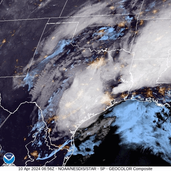
Reports are already rolling in from places as varied as Katy and San Leon of building damage and downed power lines. The good news is that the worst has now passed, and we’ll have several days of much more calm weather to clean up the mess. Additionally, the region picked up some much needed rain with warmer days ahead, and the likelihood of no meaningful precipitation for the next week or so. Most of the area picked up 1 to 3 inches of rain, but a few outliers picked up 4 inches overnight.
Wednesday
As of 6 am CT the strongest line of storms has already reached Beaumont, leaving light rain in its wake in Houston. This rain, too, should end by 7 or 8 am this morning at the latest, and we’ll see northwesterly winds as a front moves into the region. Skies will begin clearing before noon, and afterward we’ll clear out completely. Highs will be in the upper 70s today. The only note of concern is that beginning around noon, and lasting for about 24 hours, we’ll see a fairly stiff north-northwest wind. At times these winds may gust up to 30 or 35 mph. This is the price of drier air in April. Lows tonight will drop into the upper 50s.
Thursday
Aside from the aforementioned winds, which should start subsiding in the afternoon or early evening, this will be a splendid day. Skies will be sunny, with ample dry air. Highs will reach about 80 degrees. Lows will drop into the low- to mid-50s, with cooler conditions for outlying areas. As I’ve been saying, this is likely to be one of our last truly chilly nights of the spring, so if that’s your jam, I suggest you be jamming.
Friday
Another stellar day. This time, there will be no wind concerns. Skies will be sunny, with highs of around 80 degrees. There will still be plenty of dry air, but with the resumption of an onshore flow that will begin to change. Lows on Friday night will drop to around 60 degrees.
Saturday and Sunday
The weekend looks fine for outdoor plans. Saturday will be partly to mostly sunny, with a high of around 80 degrees. Humidity will be rising, but it won’t really start to feel humid until Sunday. There will be a few more clouds during the back half of the weekend, but highs will still manage to reach the low- to mid-80s. By Sunday night our lows will only be dropping to around 70 degrees.
Next week
Most of next week looks warm, with highs in the mid-80s perhaps, and a mix of sunshine and clouds. We’ll see a fairly continuous, robust southerly breeze. It will feel humid outside, but certainly not the kind of humidity we’re used to feeling later in the summer months. The next front looks like it may be about 10 days away.

That was some INTENSE lighting in League City!! And the thunder didn’t get a chance to catch up to it!
I enjoyed the thunder & lightning -Oda May (5 year old Boxer) not so much -I live in Willis, TX north of Houston we got a show
My home weather station showed 5.00” of rain overnight. With a nice display of lighting thrown in.
A question for another day – why does it appear that when a strong system is over Texas, areas North & East of Houston gets the rough weather while Houston, comparatively speaking, does not see the same intensity. Then, once out of Texas, the system ramps back up again for Louisiana, Mississippi & Alabama. No complaints at all…just curious.
I’ll take a stab at this:
When the storms are further west of us the system is pulling in Pacific moisture. As the system moves east it now starts pulling in dryer air from the Mexican deserts, losing strength. The further east it goes it can now tap into the Gulf moisture column.
One also needs to look at the temperature columns. In the desert west (warm at the surface, very cold higher up) it is easier for storms to lift the moisture further into the atmosphere, intensifying the storms. In the Houston area, for the most part, there is not a lot of temperature difference until you get way up into the atmosphere, which stifles lift. This is why we tend to get more tropical rainfall then we do severe type weather. But not always.
Perfectly stated! 👍👍
Thank you! I tend to not ask questions on social media because sometimes the responses are not kind. I appreciate your response and it makes perfect sense. Thanks again.
thanks, I’ve wondered that too. Always seems like Humble-Baytown-Beaumont get it worse than Houston proper or the west/SW sides of the area
There was a tornado last night. It hit our neighborhood HEB. IN MY DREAMS I could see HEB from my backyard (can’t see it irl). There was a cyclone of grocery carts filled with groceries swirling high up into the sky. I started screaming for my kid to come down from upstairs. This is when I woke up and heard the storm raging outside the window I sleep less than 2 feet from. It’s so cool how my brain heard the storms while I was sleeping and processed a tornado in my dreams. I woke up frantic and walked around the house for about 30 mins when the storms calmed down and I went back to bed. Checked on things this morning and no damage so that’s good. Hope the HEB is ok. 😆
That is funny and I have also had similar experiences where I could hear a storm in my dream and it is usually worse in my dream than it actually is irl. The brain is a funny thing sometimes lol
Eric, any chance we could get a rundown on the development of this storm and its movement? Around midnight, a very strong line of storms was progressing east at about 45 mph. But that advance halted around Schulenburg like it hit a brick wall. What caused the storm to act like that?
I noticed that too and am curious about it.
I’m not sure if this is related, but I set up a time lapse video to record the storm’s passage. Before the storm hit, the clouds were rolling in steadily from the south/southeast and then suddenly everything shifted to come from the west. Maybe the storms slowed down as they encountered the onshore flow from the Gulf?
Noticed that as well, there was also a line of storms from around El Campo to Wallis that developed and quickly intensified ahead of the main line to the west, which dropped off nearly as fast, like it had all the energy sucked right out of it. Here in Sealy we were between those two lines and, at least in my neighborhood, only experienced a brief period of heavy rain. Overall, nowhere near as bad as I was expecting.
The main reason I look at the forecast for Sealy is because that is where I mostly park next to the Main Street park to start my bike rides to cycle over the Fayetteville. I like Sealy, nice place to live – except it needs an HEB! 🙂
Oh my goodness! You forgot to tell Katy to evacuate!!!
They know the drill
I live in Sienna. At a PWS about 200 yards from my house, we measured 1.51″ of rain, with most coming at about 3:45 am. Rain rate was over 4″ per hour, but only for a short while. Wind got to 14 mph with gusts to 10 18. So nothing real bad down here. When the hard rain did start at 3:45, the air temperature went from 74 F to 64 F in just a few minutes.
But we survived another one……..
What nasty line of thunderstorms? Almost 1.5″ inches of rain, but no thunderstorms.
Near Ellington Field.