Summary: Much of the area is likely to see a line of intense thunderstorms move through early on Wednesday morning. We’re most concerned about the potential for damaging winds, hail, and tornadoes.
We’ve seen more data today that supports the development of severe storms early on Wednesday morning, including an unstable atmosphere and the kind of shear that promotes strong thunderstorms. There’s more one might say in meteorological terms, but the bottom line is that there is a lot of potential energy in the atmosphere waiting to be released.
That will happen overnight, as a surface front advances across Texas. This will produce a line of storms moving from west to east across the Houston metro area. In terms of timing, I expect the line to move across Houston approximately between 3am and 7am CT. These will be progressive storms, so although the rainfall is likely to be intense, it should pass fairly quickly. Most areas are likely to pick up 1 to 2 inches, but there could be higher isolated totals.
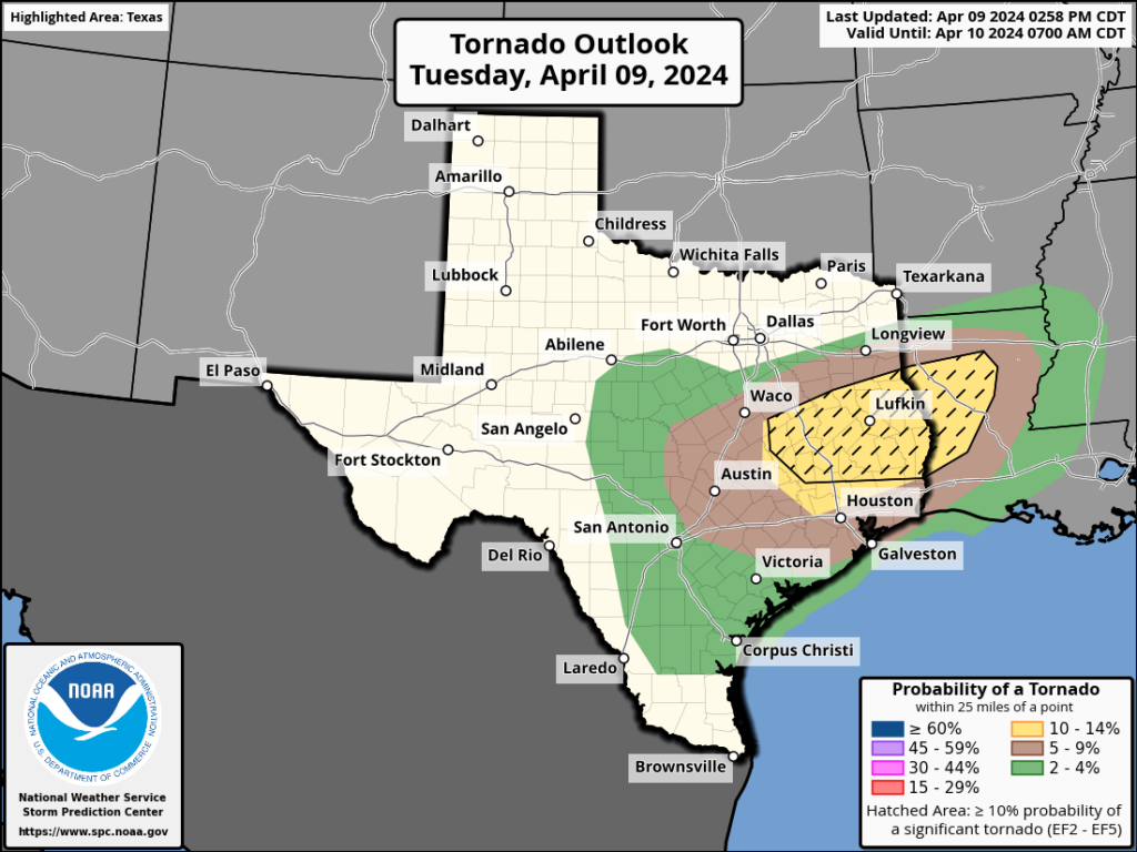
The biggest risk is not from flooding, but rather is likely to come from the threat of damaging straight-line winds, large hail, and tornadoes. Not all areas will see these effects, of course. But the majority of the area will see a period of strong winds and intense lighting and thunder. The greatest risk of severe thunderstorms is north of Interstate 10, but the models have been trending toward effects south of that boundary as well, perhaps almost all the way to the coast. In short, be prepared to be awoken tonight.
The majority of our guidance suggests that the storms pass to the east of the metro area by 7am or 8am on Wednesday, hopefully clearing out before the peak of the morning rush hour. But please be aware that some effects, such as low-lying street flooding, may persist. Skies should clear out pretty quickly as the front arrives, with drier air. Thus the rest of Wednesday looks breezy, but with no weather concerns.

Thanks for the afternoon update…I always go to you first
Another lovely night wondering if the power will go out or not, or a tree will come through my window. The constant weather anxiety of living here is taking it’s toll on my mental health.
me too… & I grew up here, didn’t used to be this worrisome
That does not sound good stranger. I hope your getting professional help to improve your mental health
If you have a tree near enough to the house that this is a risk, there’s no harm in taking out the limbs which could damage your home, or the entire tree if need be.
When it comes to the desperate need for rain, I accept we have to not be picky and take the rough with the smooth.
Thank you for the update- gives us time to prep outside
Thanks for the update! Time to move the ficus and take down the windchimes.
Thank you for the heads up alert. This thing has been sketchy all week.
I like storms, but not with this type of projected intensity ⛈
Last summer’s little solstice storm sure surprised me and I can certainly do without experiencing that again…
🌬 ⚘ ty for the info
💗 SCW 💗
In south fort bend county, very intense overnight. Been awake since 2AM, lost power at 3AM, almost 5AM and need to start getting ready for work in the dark. Today is going to be a long day.
Thanks so much for the heads up yesterday afternoon. Katy got slammed about 2:45 and we got 4.5” in the Kingsland – S. Peak area. Lots of plants blown over and tree debris, but no damage in our neighborhood.