Arctic front arrives on Sunday morning, with cold air trailing in and only a slight chance of icy roads in Houston

Good morning. The Arctic front is approaching Texas as I write this, and will sweep through the state today and tonight. It will arrive in Houston on Sunday morning, but then may stall near the coast. We’re monitoring a couple of threats from this outbreak of much colder air, including the potential for freezing rain on Sunday night and Monday, and very cold temperatures on Monday and Tuesday nights. Read on below for the latest.

Saturday

After a cold start, today is going to be sunny and lovely. We’re talking highs in the low- to mid-60s with plenty of sunshine and light winds. If you have final winterization activities to undertake, today is the day.

Sunday

The front should push into the Houston metro area on Sunday morning, reaching The Woodlands and Katy a couple of hours after midnight, and pushing down to the coast by around sunrise or shortly thereafter. The front should more or less stall along the coast, and this may lead to a fairly widespread divergence in high temperatures on Sunday.

Temperature forecast for 9 am CT on Sunday, just about when the real suffering begins in the Houston Marathon. (Weather Bell)

Houston Marathon conditions

I want to say a few words about the Houston Marathon, and what my fellow runners can expect. At this point conditions don’t look extremely cold for the run, but they do look decidedly chilly. With the front likely arriving just before we call cram into corrals, you can expect race time temperatures of about 40 degrees, give or take. Winds will be out of the north at 10 mph or so, with some higher gusts, so with the wind chill it will likely feel like the mid-30s or so. I expect partly to mostly cloudy skies for most of the morning and early afternoon. The good news is that I don’t anticipate any precipitation with the front, or afterward, so we should stay dry. Please dress accordingly.

Highs on Sunday afternoon will vary depending on your location. Areas near the coast may warm up to about 50 degrees, but locations to the north and west of Houston may stay stubbornly in the upper 30s. In any case, there should be no difficulty getting around.

Sunday night and Monday

It looks like most of Houston will remain just above freezing on Sunday night and into Monday. It will be quite cold, in the upper 30s, probably. That’s good, because there is a chance of some light precipitation late on Sunday night and Monday as a modest disturbance crosses the area. In terms of accumulations, it’s not going to amount to much. But the concern is freezing rain, and potential icing on bridges and overpasses. All of our available modeling continues to suggest that the threat of this in Houston is low, as temperatures should remain just above freezing on Monday.

Latest National Weather Service forecast for freezing rain on Sunday night and Monday. (Weather Bell)

The bigger threat comes to the north of Houston, roughly along Highway 105, and to the west of Sealy. Needless to say we’ll be keeping close tabs on the potential for any freezing rain near or in the Houston metro area as plenty of uncertainty remains. Finally, if you’re traveling to north Texas on Monday, the potential for freezing rain and sleet is much higher as you head that way. Precautions are most definitely warranted for any travel north on Interstate 45 beyond Conroe.

Monday night and Tuesday

Rain chances end later on Monday, and we’re going to see stronger northerly winds. This is when a second surge of colder air will move in. This reinforcing front will drive lows into the 20s for the Houston metro area on Tuesday morning, but we still have some questions about how cold it is going to get. There is a scenario in which mostly cloudy skies help keep most of the metro area at 25 degrees or higher on Tuesday morning. But if skies clear faster we could see lows bottom out at about 20 degrees, with high teens for Katy and The Woodlands. All of this looks pretty cold, but manageable.

Most locations along and south of Interstate 10 should briefly climb above freezing on Tuesday, but areas further inland may struggle to reach freezing temperatures. In any case, it will be sunny and cold. But with dry conditions it should be fine to be out and about.

NWS minimum temperature forecast for Wednesday morning. I think this is a realistic worst-case scenario for the cold. (Weather Bell)

Tuesday night and Wednesday

With clear skies and lighter winds, Tuesday night should bring ideal conditions for cooling into Houston. I expect the urban core of Houston to drop to between 20 and 25 degrees, which will be a hard freeze. Outlying areas, including The Woodlands and Katy, will have a risk of dropping into the upper teens.

By Wednesday afternoon, with lots of sunshine, we should see highs comfortably in the 40s. This will bring an end to the risk of a hard freeze.

We’ll have an update this afternoon to refresh any changes in this forecast. Have a great Saturday, everyone.

What to expect across Texas with the hard freeze; latest on timing and wintry mix in Houston

Good evening. We’re continuing to track the evolving forecast for a hard freeze in Houston, which has implications for the Houston Marathon on Sunday, the MLK Parade on Monday, and a host of other activities in Houston and beyond in the state of Texas. This post will update all of that, and well as provide a more holistic view of impacts to Texas. Be sure to read that section if you’re planning to be driving among the cities of Houston, Austin, Dallas, and Fort Worth on Monday.

How to follow us

Before jumping into the forecast, I want to provide a short summary of how to find and follow Space City Weather as the prospect of a freeze has brought us new readers.

EMAIL: If you want to get every post emailed to your inbox (without tracking or other extraneous nonsense) you can sign subscribe via email. (It’s free, and always will be). The box to input your email is either at the bottom of this page, on mobile, or on the right-hand side, on desktop.

APP: You can download our app (iOS version or the Android version). Both are free. You can read more about it here. Also, our use of “Houmidity” is not a bug!

SOCIALS: In terms of social media, we try to be wherever you are. Houston Chronicle tech columnist Dwight Silverman, who manages the development of our weather app, has expanded his role to help with social media so we can be on more platforms. Accordingly, SCW has now a presence on X (formerly known as Twitter)FacebookInstagramThreadsMastodon and Bluesky

Forecast low temperatures for Tuesday morning. (Weather Bell)

The latest forecast

Not a whole lot has changed today, in comparison to what Matt wrote this morning. Today’s blustery winds will settle down this evening, and after a chilly night in the 30s we’ll see a very pleasant Saturday. Look for highs in the mid-60s with plenty of sunshine and light southerly winds. It’s a near ideal winter weekend day. Unfortunately, the pleasant weather will end soon thereafter.

Most of the model guidance is still bringing an Arctic front into Houston by around sunrise, plus or minus a few hours, on Sunday morning. This will be a cold day, likely with high temperatures in the upper 30s or lower 40s for most locations. If you’re running the Houston Marathon, I’ll have a full rundown of what to expect for race weather in Saturday morning’s post.

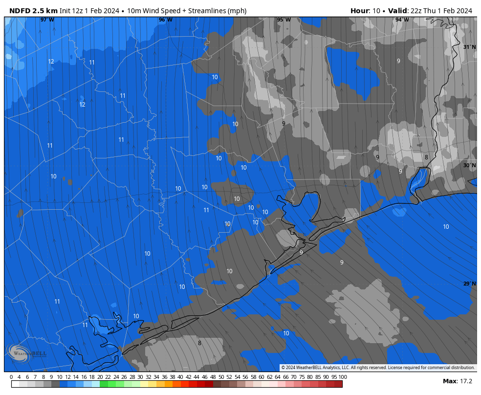
European model for wind gusts at 8 am CT on Sunday.

Most of the metro area should remain just above freezing on Sunday night, or experience a light freeze at most. But we start to have some concerns on Monday, a holiday for many in remembrance of Martin Luther King Jr. It will be a cold day, with highs likely in the upper 30s for most. That’s fine, but there is the threat of some light precipitation during the daytime hours. This is likely to fall as freezing rain north of Houston, perhaps in The Woodlands, or perhaps further north. I still don’t feel confident in saying how much of an impact this is going to have an roadways, especially if the rain stops while temperatures are still above freezing, and the winds help dry roads. But it could be factor Monday evening or Tuesday morning. We’ll see.

Monday night has been trending slightly warmer in some recent model runs, but I still think most of the area is going to fall below 25 degrees, with sub-20 degree temperatures possible for areas west of Houston (i.e. Katy) and north of Houston (i.e. The Woodlands). However this is something we’ll continue to monitor.

Tuesday is going to be sunny and cold, with highs perhaps around freezing, perhaps a degree or two above freezing. This will set the stage for ideal cooling on Tuesday night, with lows likely dropping into the low 20s in the urban core of Houston, with colder conditions for outlying areas. How cold? We’re just going to have to continue to monitor temperature trends. We warm up Wednesday and will be in the clear in regard to freezing temperatures.

Texas temperatures

Let’s step back and take a broader look at the state of Texas, as a whole. To begin with, I went back and pulled the record cold temperatures for Texas during the depth of the 2021 freeze, which occurred in mid-February.

Amarillo-11 degrees
Austin 8 degrees
Corpus Christi17 degrees
Dallas-2 degrees
El Paso14 degrees
Houston12 degrees
San Antonio9 degrees
Waco -1 degree
Table showing minimum temperatures recorded in February 2021.

Next, let’s look at the current forecast for low temperatures next week. I’m showing the map for Tuesday, since that will be the coldest morning for the vast majority of the state. If you compare the record lows above, most locations will be solidly 5 to 10 degrees warmer than the cold snap.

Low temperature forecast for Tuesday morning. (Weather Bell)

This is one reason why we have some (not total, to be sure) confidence that the statewide electricity grid will hold up next week. ERCOT, for its part, expects “normal” conditions next week in terms of grid performance.

Sleeting in the Lone Star State

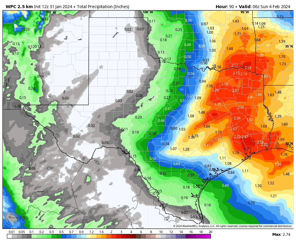
Beyond the cold conditions, the other concern for statewide weather is the potential for wintry precipitation to muck up roadways. Atmospheric conditions do not favor snowfall in Texas—sorry kids. However there is likely to be some overrunning precipitation on Sunday night Monday across the eastern half of the state, meaning that there will be a layer of warmer and wetter air aloft, and this will allow for sleet or freezing rain to fall. Forecasting this kind of precipitation in Texas is always a challenge, so this is something of a hand-waving exercise. But in terms of timing there is a chance of some light, freezing rain from from roughly Austin to College Station to the northern Houston suburbs on Monday. Here is how the GFS model forecasts freezing rain early next week:

GFS model forecast for freezing rain accumulation on Monday.

Somewhere along the way from Houston to Dallas, this freezing rain it is going to turn to sleet. There is a pretty simple reason for this. Freezing rain is very cold rain that freezes when it hits the ground. Sleet is rain that re-freezes before it reaches the ground, and is sometimes referred to as ice pellets. So as temperatures get colder near the surface, sleet becomes more likely. But it’s difficult to say where this turnover will occur. Accordingly, sleet or freezing rain will be possible on Sunday night and Monday in parts of north and East Texas, including the Dallas-Fort Worth area. The bottom line is that, if your plans call for travel between Houston, Dallas, and Austin on Monday, you should pay close attention to road conditions before setting out.

Sleet accumulation forecast for Monday in Texas. (Weather Bell)

In summary, a serious cold spell is coming to Texas. The good news is that it will not be nearly as cold as 2021, nor last nearly as long. Our electricity grid and the power plants that supply it have also been winterized since then. There still could be problems, but I don’t expect them to be insane like three years ago.

We’ll be back with a comprehensive post on Saturday morning.

Afternoon update on the Arctic front: Here are the three main things we’re watching

As promised, we’re providing a p.m update on the cold weather we’re anticipating that will arrive in Houston, beginning Sunday. We’ll be doing twice-a-day updates through the weekend to keep you abreast of what’s happening—this is a fairly dynamic situation, and the forecast is changing as a result.

This afternoon we want to try and provide some clarity on what we think are the three biggest issues: timing of the cold weather onset, chances for wintry precipitation (i.e. freezing rain), and how cold it is going to get early next week. What about electricity? At this time we don’t think there will be widespread power outages with this cold outbreak. While that it is possible, it is beyond our ability to forecast. But given that the Texas power grid held up during the 2022 freeze, there is no credible reason to think it will buckle with this cold weather outbreak.

NAM model forecast for temperatures at 9 am CT on Sunday. (Weather Bell)

When will the front arrive

The majority of model data now supports a faster arrival, with the cold front initially reaching the Houston area on Sunday morning. If this ultimately happens, it has implications for the Houston marathon, both the runners and wonderful volunteers. This forecast is still uncertain, but it seems likely that race time temperatures will be in the upper 30s to low 40s. Right now I’d lean toward 30s.

Fortunately, the passage of this front is likely to be dry. There also is no indication, at present, of strong northerly winds. So while there may be gusts on the order of 15 to 20 mph, I don’t see much evidence of crazy strong winds we sometimes get with “blue norther” fronts. So expect partly sunny and cold on Sunday, with daytime temperatures perhaps in the upper 30s. We should have more confidence in these temperatures in a day or so. But confidence is high that it’s going to be cold.

The very coldest air is going to be delayed, so my expectation for Sunday night is that much of the region will probably experience, at most, a light freeze. This really should not raise too much of a concern. Daytime temperatures on Monday should be above freezing for most of the region.

Chances for wintry precipitation

Sunday looks dry, as does Sunday night. After that? Well, quite frankly it’s too early to say too much. There appears to be a chance of freezing rain during the afternoon or evening hours on Monday. My best guess is, at this point, that the freezing stuff stays north of the metro area. It could be an issue for areas along and north of Texas State Highway 105. It could surprise us and come further south.

So I would say this: We need to consider the possibility of icy roads on Monday evening and during the overnight hours into Tuesday morning. I think it’s a fairly low concern within the Houston metro area, that is for The Woodlands and points south. But with that said, it’s far too early to issue any kind of guarantees. We’ll be watching this closely in the coming days, of course.

Low temperature forecast for Tuesday morning in Houston. Subject to change. (Weather Bell)

How cold things will get

Our real concern for cold will come starting Monday night. Temperatures will bottom out in the morning hours on Tuesday and Wednesday. The forecast remains fuzzy because there are a lot of factors that will go into how low things get, from clouds to winds, to the amount of Arctic air that spills into Texas. But a good guess is that both nights will see lows in the upper teens to low-20s north of Interstate 10, and low-20s south of Interstate 10. The coast may avoid a hard freeze.

Daytime temperatures on Tuesday probably will briefly get above freezing for most of the metro area, but my confidence in that is fairly low. Houston should then warm comfortably above freezing on Wednesday.

We’ll have a comprehensive update for you on Friday morning.

Arctic air is coming to Texas, possibly as early as Sunday morning

Good morning. There are some changes in the forecast for our upcoming cold spell, which looks to arrive earlier than anticipated. There is also a slight chance of some wintry precipitation on Sunday night into Monday morning, but the overall odds remain against this for now. The key point is this: There remains a lot of uncertainty about the details of this Arctic outbreak, but they should come into better focus over the next 24 to 36 hours. So please be patient. Matt and I will be here all along the way to tell you what we know, and what we don’t. For now, any preparations you make for the cold should be completed by the end of Saturday.

Thursday

As expected there is fog, some of it dense, across much of the metro region this morning. As it clears we’ll see partly sunny skies and warm temperatures today, with highs pushing into the mid-70s. Southerly winds, gusting at times to 20 or even 25 mph, will be possible. Conditions change tonight as a fast-moving front drops through the area. Expect it to arrive near Katy and The Woodlands a couple of hours after midnight, push into Houston during the wee hours, and move offshore before sunrise. A broken line of showers, and possibly a few thunderstorms, may accompany the front. Overall rain chances are fairly low, however, as I expect a capping inversion to hold sway.

Highs will be in the 70s today … for the last time in quite a while. (Weather Bell)

Friday

This will be a cold, blustery day. Skies will be sunny, but winds will be strong out of the north, gusting to 35 mph or so at times. If you’re like me and just finished picking up limbs from winds earlier this week, prepare for round two. Highs will reach the upper 50s, but may stop there. Winds will drop off pretty significantly during the afternoon and evening hours, and this will allow for ideal cooling conditions overnight. I expect lows in most of the Houston metro areas to remain above freezing, but a light freeze is possible for inland areas.

Saturday

After the cold start this will be the last warm-ish day before the Arctic front arrives. We’re looking at partly sunny skies, with high temperatures in the low 60s. Winds will be light. Lows on Saturday night will drop into the low- to mid-40s.

Sunday

Alright, here’s where the uncertainty kicks in. We’re just coming into range of some of the higher-resolution models, which tend to do a better job handling the timing of colder air masses like this. As we see additional model runs today, we should continue to get a better focus on the timing of the front. So I want you to understand that my confidence is low here, and we’re going to need to write the forecast in pencil for a little while.

With that said, the high resolution modeling is indicating that the front could reach Houston by around sunrise on Sunday. Yes, you read that right. If this is the case, temperatures on Sunday morning could be in the 30s for Houston marathon, with northerly winds. (I don’t expect precipitation at this time). This obviously is a significant change from previous forecasts, and something we’ll need to fine-tune. Again, it depends on the timing of the front.

A widespread freeze looks likely for Sunday night, with areas inland of Interstate 10 possibly seeing lows in the mid-20s.

As to the question of freezing precipitation, there are hints of it in the models but nothing concrete. We really need to see more data from the high-resolution outputs before I have any confidence. For now I’d rate the chance of seeing any wintry precipitation, either in the form of sleet or freezing rain, at about 25 percent. I still don’t think it will be significant issue for roadways, but obviously it’s something we’re going to be watching closely.

Current forecast low temperatures for Tuesday morning. (Weather Bell)

Monday

This will be a cold day, with highs likely in the mid-30s for most of the metro area. As part of this Arctic front, lows will bottom out on Monday and Tuesday nights. Again, with these temperatures, there is some considerable uncertainty. For areas south of Interstate 10 we are probably looking at lows in the low to mid-20s, whereas areas further inland will be upper teens to low 20s. We will see.

We’ll have another update this afternoon to see where we are with the frontal timing, and lows early next week.