Good morning. Today marks the beginning of the Atlantic hurricane season, which will last for the next six months. It’s also a big day for Matt and myself, as we’re launching a new website devoted to tropical weather in the Atlantic Ocean, Gulf of Mexico, and Caribbean Sea. It’s called The Eyewall, and you can head over there now to check it out, and find out more information about what we’re doing. But I’m sure some readers will have questions about what this means for Space City Weather, and that’s what I’m going to address now.
Is Space City Weather going to change?
No.
Like not at all?
Like not at all. Matt and I are 100 percent committed to Space City Weather, and improving it every way we can. To that end, look for an updated version of our app soon, that squashes some bugs and delivers the much-asked for dark mode feature in addition to other goodies.

Why are you doing this?
There are two primary reasons. One, much of the current national hurricane coverage is sensationalized, and we think there is room for a different, no-hype approach. And two, we are frequently asked for local sites during hurricane season. (I.e. my mom is in Destin, where can she get this kind of coverage for Tropical Storm X or Hurricane Y) Well, now we’ve got an answer. We’re counting on you to tell friends and family beyond Texas.
Will there be cross-over between the two sites?
A little bit. The Eyewall will publish a “Daily Tropical Outlook” every weekday, and weekends as needed. There will be other hurricane content as well, and lots of coverage of active storms threatening land. Once a week we will cross-publish one of these “tropical outlooks” on Space City Weather (i.e. like with our weekly tropics report).
What happens if a hurricane threatens Texas?
For Space City Weather we cover the storm as usual. The local material would then be cross-posted onto The Eyewall. But our intent is that for readers of Space City Weather there will be no noticeable changes. We will not be publishing content from the Eyewall about storms affecting other parts of the country, or Mexico and the Caribbean Islands here, although we may link to it from time to time on Space City Weather.
Do you have a sponsor?
Not yet. Really, this is an experiment. Matt is taking on a big extra burden with this, and while we’re going to have some contributors, we want to see if this is sustainable. We also want to see if there are readers for this. Maybe it flops. Maybe it doesn’t. Really, we just want to give people some comfort in a terribly trying and traumatic time in their lives. We’ll see.
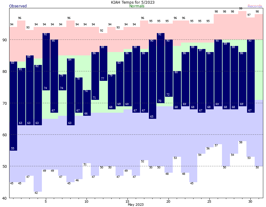
Now, onto the forecast…
Thursday
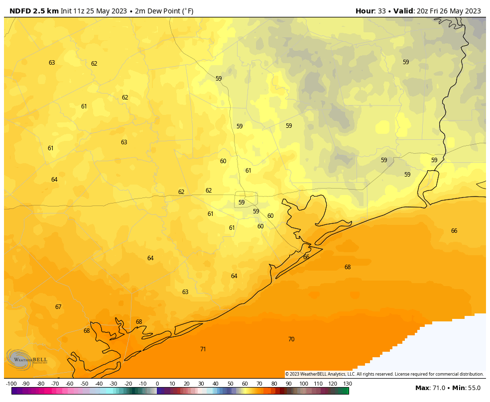
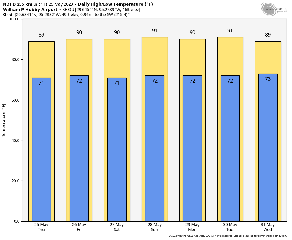
Our weather for the next few days will be guided by a modestly strong ridge of high pressure. This means we’re going to see warm and sunny weather. Highs today should reach about 90 degrees, with light southeast winds. One nice aspect of the weather is that dewpoints have not reached hair-melting levels yet, so the humidity won’t be oppressive. Lows tonight drop into the low 70s. Rain chances today are about 10 percent.
Friday
A little warmer, with highs in the low 90s. Otherwise, pretty much the same as Thursday.
Saturday
Another day with mostly sunny skies and highs in the low 90s. For areas far north of Houston, likely even north of Conroe, there is a slight chance of some rain showers later in the day.
Sunday and Monday
As high pressure eases off, skies will become more cloudy in response to rising atmospheric moisture levels, and our rain chances will go up. Both Sunday and Monday should see about a 50 percent chance of rainfall, with accumulations in the order of 0.25 to 1 inch. Overall chances are probably a bit higher north of Interstate 10, but this far out I don’t have great confidence in that. The clouds should bring highs back down to around 90 degrees on both days.
Later next week
Rain chances continue for a few more days, helping to tamp down high temperatures. But it’s possible that we’re headed toward the low- or even mid-90s by later next week. Hello, June!