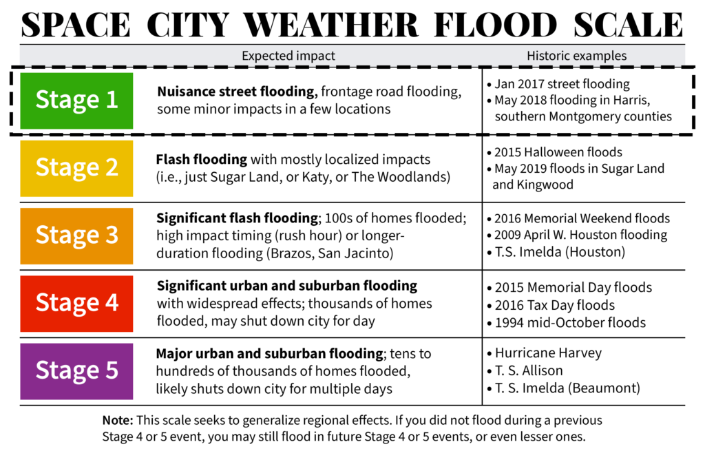
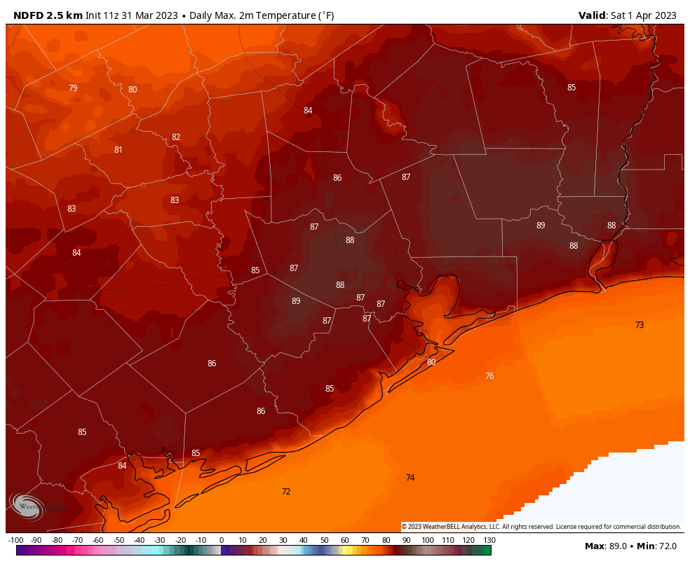
Good morning. Today will be the region’s last “hot” day for awhile, with temperatures in the upper 80s. A cold front will arrive on Wednesday to usher in several cooler and wetter days for the region. Because of the potential for rainfall accumulations over time, we have issued a Stage 1 flood alert for the period of noon on Wednesday through Friday. This means you can anticipate the potential for at least some nuisance street flooding. I do expect the rainfall to end in time for Easter Sunday, by which point the weather should be fairly pleasant.
Tuesday
Skies will be mostly cloudy today with a pronounced southerly wind, at about 15 mph, with gusts up to 30 mph. Highs will reach the mid-80s, at least, with plenty of humidity. Winds will continue through most of the overnight hours, with low temperatures only dropping into the mid-70s for most.
Wednesday
The morning will start out warm and cloudy. It now appears that the cold front will not reach central Houston until around noon or the early afternoon hours. There will probably be a broken line of showers and thunderstorms with the front as it moves through on Wednesday and pushes just off the coast. While there is the possibility of heavy rainfall during this time, it is important to note that I do not think this will be the “main event” when it comes to rain this weekend. That probably will come on Thursday and Friday. Temperatures will drop back into the upper 60s after the front’s passage, and down to around 60 degrees on Wednesday night.
Thursday and Friday
These two days will serve as the focus for heaviest rainfall as the aforementioned front more or less gets hung up right along the coast. Stalled fronts, which open the door for atmospheric disturbances, have historically been rainmakers for Houston (Tax Day floods, anyone?). Precisely where this front stalls out is not yet determinable, but that will be where we can expect the heaviest rain. Highs, generally, will be in the 60s.
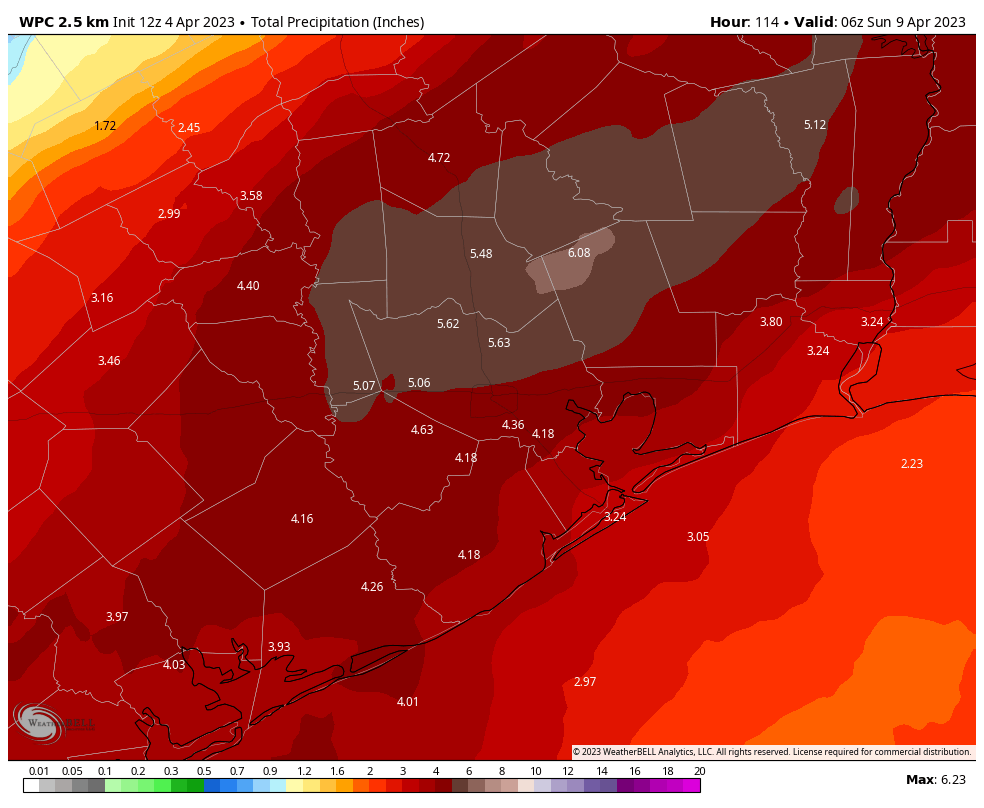
For now I’m going to ballpark rain widespread rain totals of 2 to 6 inches of rainfall this week, with higher isolated totals. Most of this will come sometime on Thursday and Friday. There won’t be continuous rainfall during this period, but there is the potential for at-times heavy rainfall that could cause some street flooding—hence the issuance of a Stage 1 flood alert. This basically means that you need to be weather aware before venturing out. It probably will be fine, but check to make sure. Matt and I will be covering the heavy rainfall as much as needed.
Saturday
We’re still going to see about a 50 percent chance of rain on Saturday, but things should be winding down as the stalled front finally gets un-stalled and moves away. Otherwise, expect cloudy skies and high temperatures of around 70 degrees. Overnight lows will drop into the low 60s.
Sunday
By Easter Sunday we’re down to about a 10 or 20 percent chance of rain. Skies will probably start out cloudy, but by the afternoon we could see some sunshine peaking out. Highs will likely reach the mid- to upper-70s. Lows on Sunday night will drop into the mid-60s.
Next week
Overall our weather next week looks comparatively calm, with partly to mostly sunny skies, highs in the mid-80s, and lows somewhere in the 60s. Humidity returns, but at this point it looks like dewpoints will not be impressively high. So, not bad for mid-April?