The very worst of the heat is over, at least for now. The very thick ridge of high pressure influencing our weather continues to retreat westward, and this should help nudge high temperatures downward a bit, toward the mid-90s eventually. Additionally, our rain chances will improve moderately over the next several days. However, it appears as though the potential for heavy rainfall from a tropical system will remain to our east, over Louisiana.
Tuesday
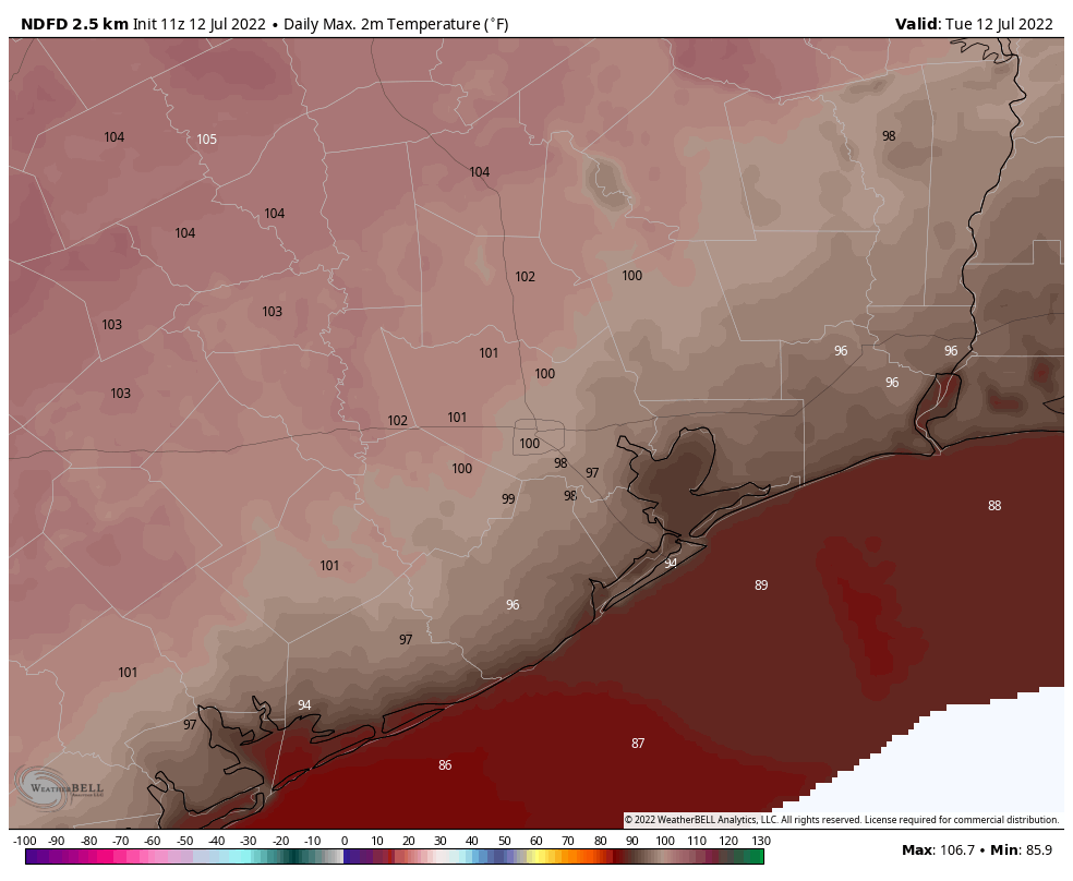
The high temperature on Monday at Bush Intercontinental and Hobby airports reached 103 degrees, and today should be a couple of degrees cooler to go along with mostly sunny skies. The century mark will still be reachable for much of the region away from the coast, however, so please continue to take heat precautions. Winds will be very light, perhaps blowing at 5 mph out of the southwest or west. Rain chances are about 20 to 30 percent near the coast today, and perhaps 10 to 20 percent inland. If there were a way to buy multiple rainfall raffle tickets, I’d definitely be in “Take my money!” mode.
High temperature forecast for Tuesday. (Weather Bell)
Wednesday
Another day a lot like Tuesday.
Thursday and Friday
These days may be a bit cloudier, and cooler, with highs perhaps topping out in the mid-90s. I’m hopeful that daily rain chances will be in the range of 40 percent, and there should be a few lucky areas picking up 1 inch or so. The rest of us? Probably not so lucky.
Saturday and Sunday
The weekend looks similar, with highs probably slotting somewhere in the mid-90s, and rain chances perhaps in the 30 percent neighborhood. Skies should be mostly sunny.
Next week
The forecast for early next week is still somewhat uncertain. It does seem possible that high pressure will start to build back in over the region, pushing temperatures up. However, there are also some scenarios in which conditions stay in the mid-90s, with pretty healthy daily rain chances. I realize that’s not very helpful, but it’s the best I can do right now.
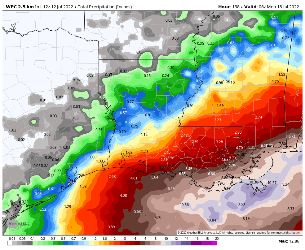
NOAA rainfall accumulation forecast for now through Sunday. (Weather Bell)
Tropics
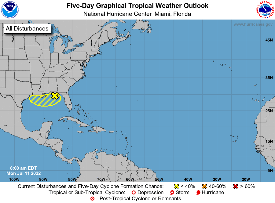
The National Hurricane Center is continuing to predict that a tropical blob near the Louisiana coast has a 30 percent chance of becoming a tropical depression or storm during the next five days. This is likely to make for very wet weekend in Southern Louisiana, with 5 to 10 inches possible in and around New Orleans. Unfortunately, Houston is likely to fall just outside the heavy rainfall boundary as the system moves into Louisiana.
Sunday’s heat was extreme for the greater Houston area. College Station, for example, set a daily record for July 10 by reaching 111 degrees. This was also its second hottest day on record, in any month, ever. In Houston, four of the first 10 days of July have now recorded 100-degree days. Sunday’s mark of 105 degrees tied the record for the hottest degree for any day in July. Anyway, here are the maximum temperature records set or tied on Sunday:
City of Houston: 105 degrees (101, set in 1998) Houston Hobby: 104 degrees (100, set in 1964) Galveston: 96 degrees (96, set in 1931) College Station: 111 degrees (109, set in 1917)
It is worth noting that all of these locations also set or tied minimum temperature records on Sunday. For example, the low temperature in Houston never fell below 82 degrees. So overall you just experienced the warmest July day in nearly 150 years of records along the upper Texas coast.
Congratulations, or something.
I realize that some readers get twitchy when we write about about climate change. This is a weather site, not a climate site, and that’s our focus. But here’s the reality. Houston experienced an extremely hot and dry summer in 2011, just 11 years ago. At the time, it seemed historic. Also, as someone who lived through it, I can attest that it was miserable. But now 2022 may be on course to match or exceed it, at least in terms of heat. This is not normal. People can have reasonable debates about the precise causes of this excess heat, and what to do about it. But Sunday’s weather was atrocious, and not a future I particularly want to leave to my children.
Monday
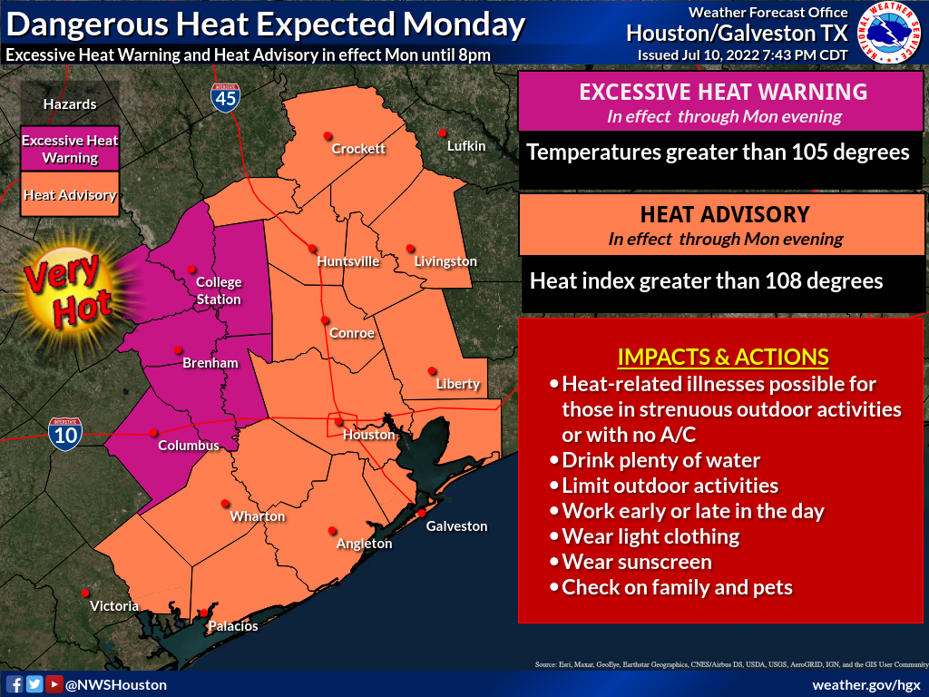
The heat continues, albeit with slightly less burn, today. The National Weather Service has kept an “excessive heat warning” in place for the region’s far western counties, including the College Station and Brenham areas, where highs are likely to reach at least 105 degrees again today. Houston should also see highs of around 100 degrees, or perhaps a touch higher. Like on Sunday, some relief may come from scattered thunderstorms that will start out north of the region and then move through during the afternoon. While the rain is most assuredly welcome, these storms could bring some briefly strong winds. Otherwise winds will be light, out of the southwest at 5 to 10 mph.
Tuesday
The intense high pressure system that baked our region over the weekend will finally begin to back off to the west, and that will start to provide some slight relief, likely keeping highs in the Houston metro area just below 100 degrees. Rain chances will likely be around 20 percent.
Wednesday, Thursday, and Friday
These will, finally, feel more like typical mid-July days in Houston. We can probably expect highs roughly in the mid-90s, but there will also be some clouds to go along with 30 to 40 percent rain chances each day. Hopefully our parched trees and lawns see some welcome rain during this period.
The weekend and the Gulf blob
Careful observers of the National Hurricane Center will note that they are now predicting a 30 percent chance of a tropical system forming in the northern Gulf of Mexico during the next five days. Essentially, a cool front is moving down into the northeastern Gulf from Georgia and the Florida Panhandle. This, this system will then drift westward across the northern Gulf of Mexico and may impact our weather this weekend.
Tropical weather outlook published on Monday morning. (National Hurricane Center)
There are a lot of unknowns here, including whether the system will significantly intensify (probably not) and how far west it will come. If it moves all the way to Texas it could bring us some significant rainfall this weekend, but if it moves into Louisiana we’re going to remain hot and dry. For now I’d guess the weekend will continue to see hot and mostly sunny weather, but the forecast comes with an asterisk at this point.
A message from our sponsor
We’re including some tips we shared from Reliant over the weekend that can help manage energy usage, regardless of your electricity provider:
Follow the 4×4 principle. Set your thermostat four degrees higher when you’re away from home for more than four hours to save on energy usage and costs.
Rotate your ceiling fan counterclockwise for a wind chill effect. This can make the temperature in a room feel up to 4 degrees cooler allowing you to be more comfortable and adjust your thermostat to save money. Don’t forget to turn off your fan when leaving the room.
Use blinds or curtains to reduce solar heat gain by up to 50 percent. Direct sunlight can increase the demand on your AC by as much as 30 percent.
Beat the Heat Centers are located across Houston to provide a safe place for seniors and other vulnerable neighbors to cool off, allowing them to decrease their energy usage at home. To see a full list visit reliant.com/beattheheat.
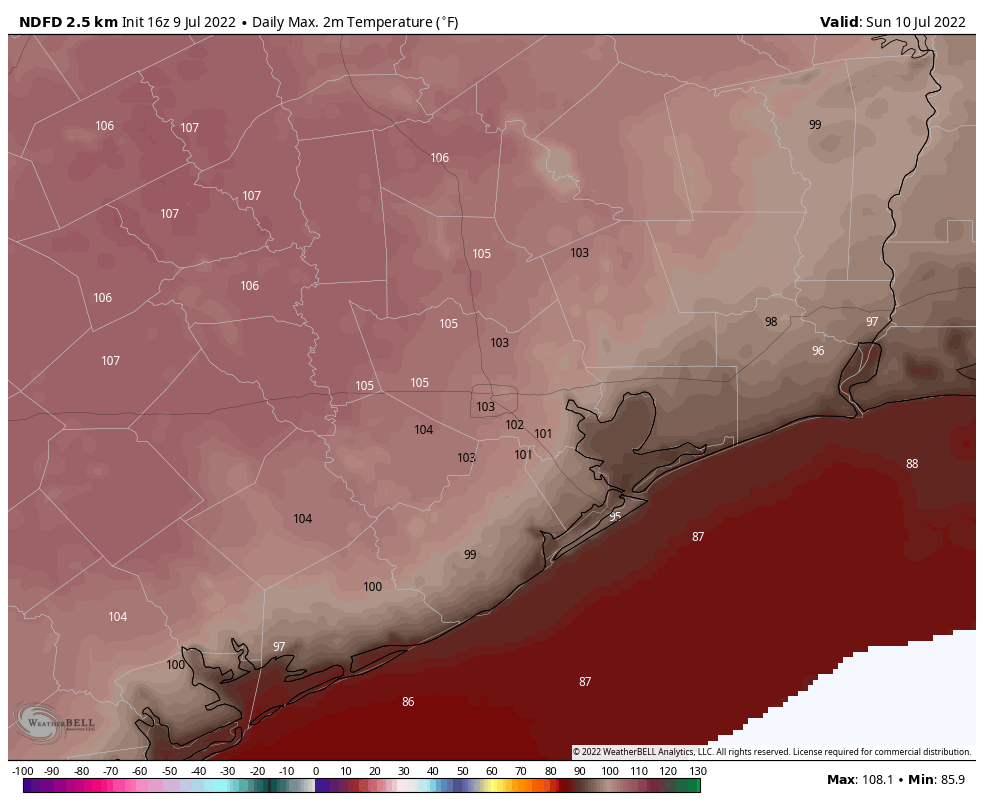
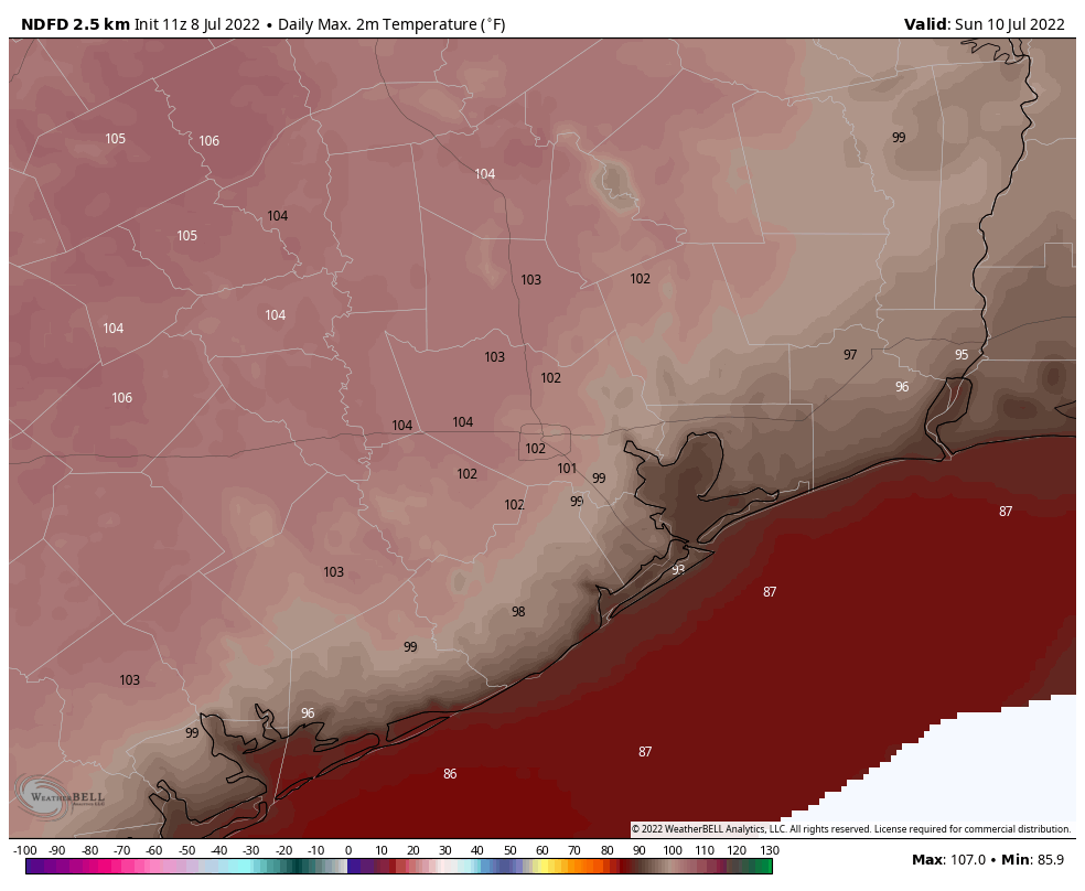
Hi everyone. Just a quick weekend post here to call attention to the extreme heat our region will see today, Sunday, and possibly Monday. Yes, we know it gets hot in Houston during the summer. But temperatures this weekend, particularly on Sunday, will reach 105 degrees or higher for some inland locations as we see peak high pressure. This is rare and dangerous heat that warrants precautions.
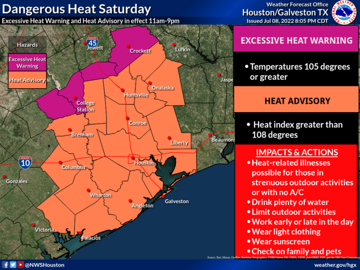
Area for an excessive heat warning for Saturday. (National Weather Service)
To that end, the National Weather Service has issued an “excessive heat warning” for far inland areas, including College Station, for Saturday. The rest of the metro area, including the city of Houston, falls under a “heat advisory” criteria. This warning area for excessive heat could be expanded further southward on Sunday, as we warm further. The last time the city of Houston, itself, fell under an Excessive Heat Warning was August 31, 2020.
This will be the hottest weather that Houston has seen this year, and raises the threat of heat related illnesses. Outdoor activities should be limited during the middle of the day, and you need to stay well hydrated.
The heat should peak on Sunday, but Monday still has a pretty good shot at hitting 100 degrees for much of the metro area. After this we should revert to a more summer-like pattern, with high temperatures starting to drop back toward the mid-90s and chances for at least some scattered rain showers. Until then, please take things easy outdoors.
High temperature forecast for Sunday. (Weather Bell)
A Message From Our Sponsor, Reliant
Our thanks to Eric and Matt for keeping Texans informed during another hot Texas summer. With the high temperatures in the days ahead, Reliant wants to ensure everyone has the latest information to manage their energy usage and stay cool. Below are helpful tips you can apply, regardless of your electricity provider:
Follow the 4×4 principle. Set your thermostat four degrees higher when you’re away from home for more than four hours to save on energy usage and costs.
Rotate your ceiling fan counterclockwise for a wind chill effect. This can make the temperature in a room feel up to 4 degrees cooler allowing you to be more comfortable and adjust your thermostat to save money. Don’t forget to turn off your fan when leaving the room.
Use blinds or curtains to reduce solar heat gain by up to 50 percent. Direct sunlight can increase the demand on your AC by as much as 30 percent.
Beat the Heat Centers are located across Houston to provide a safe place for seniors and other vulnerable neighbors to cool off, allowing them to decrease their energy usage at home. To see a full list visit reliant.com/beattheheat.
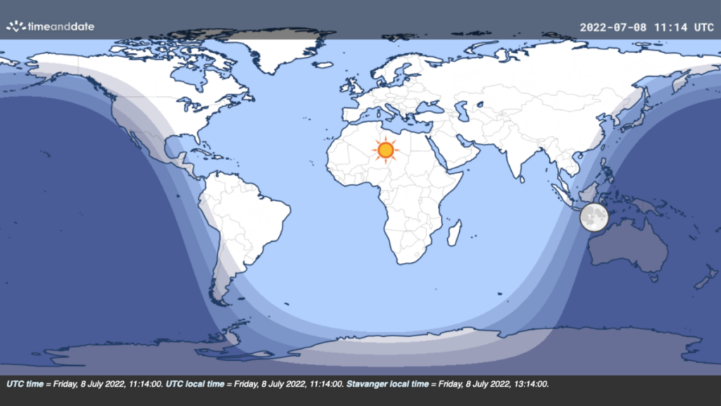
Today is a special day. At 6:15am CT local time in Houston, 99 percent of the world’s population is illuminated by the sun. Of these 99 percent, the vast majority are in direct sunlight, while the remainder are in some form of twilight. Only parts of Australia, New Zealand, and Papua New Guinea are in full darkness at this time. As to why this occurs a couple of weeks after the summer solstice, and not on the summer solstice, that has to due with the distribution of the world’s population, and the location of Earth’s landmasses. TimeAndDate has more detail on all of this in a great fact-checking post.
99 percent of the world’s population falls beneath the Sun this morning. (TimeAndDate.com)
Speaking of that sun, we’ll see plenty of it during the days ahead. This weekend looks extremely hot before conditions start to moderate a little bit more each day next week. It will be nice to have daily rain chances again.
Friday
Areas inside Loop 610 won the rainfall lottery on Thursday, but the chance of hitting an isolated rain shower today is less than on Thursday. Instead, we can simply expect mostly sunny weather, with highs in the upper 90s to 100 degrees in Houston, and warmer conditions still for far inland areas such as College Station. Winds will be light, out of the southwest at 5 to 10 mph. Overnight lows probably won’t drop below 80 degrees.
Saturday
Look for very hot weather, with highs at or above 100 degrees for much of the area with sunny skies. Please take precautions due to the heat during the middle of the day.
The high temperature forecast for Sunday is no joke. (Weather Bell)
Sunday
This will be another hot and mostly sunny day, probably the hottest of the period. However, there is a slight chance, perhaps 10 to 20 percent, of an afternoon shower or thunderstorm kicking up along with the sea breeze. I mean, probably not. But maybe.
Next week
The details for next week’s weather remain a bit fuzzy, but the overall trend should be one toward more typical weather for mid-July in Houston. That means that as we get toward the middle of the week highs likely will slot somewhere in the mid-90s, with a decent 30 or 40 percent chance of rain each day. After the last few days, that doesn’t exactly sound terrible, does it? We’ll be back on Monday with some more clarity on those details. Until then, please take the heat seriously this weekend.