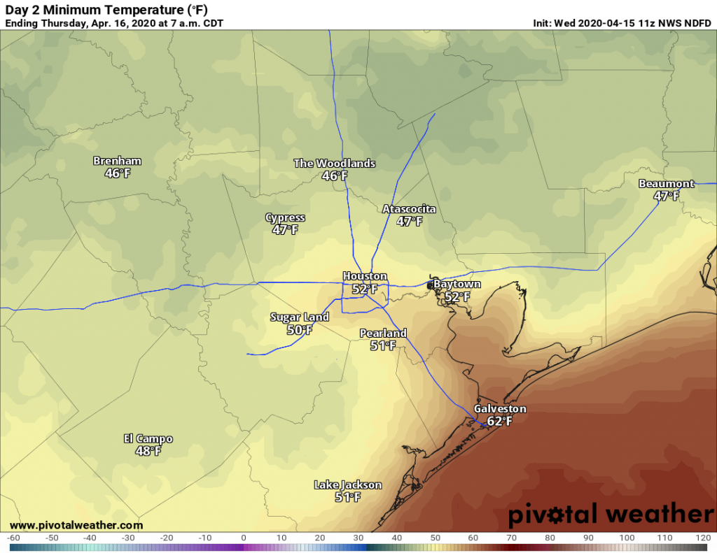
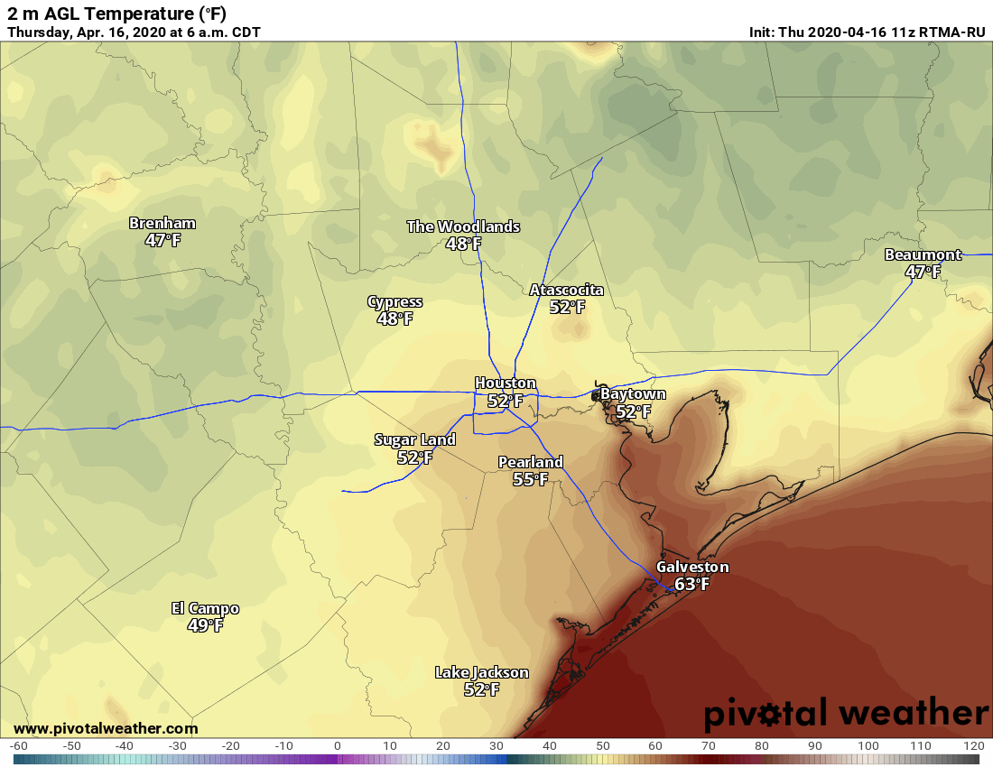
A little more heat, a little rain, and an eye on the tropics

Scattered rain chances will continue through the middle of the week before sunnier skies return for the first half of the weekend. There still are no real signs of a cold front, alas, but we will need to keep an eye on the tropics over the next couple of weeks—which we’ll discuss below.

Tuesday

Similar to conditions on Monday, we’re going to see some scattered showers develop later today as Gulf of Mexico moisture streams inland. But as there is no real trigger for this atmospheric moisture to precipitate out of the sky, rain chances for most of the region will only be about 30 percent. Skies will be partly sunny, and whether high temperatures climb into the mid- or upper-90s will depend upon the extent of cloud cover and rainfall near you this afternoon. But we can safely say it will be hot.

Most of Houston should see some at least some light rain over the next three days. (Pivotal Weather)

Wednesday

Another day similar to Tuesday, albeit with higher atmospheric moisture levels. This should nudge rainfall chances up into the 50 percent range, and thunderstorms could briefly be fairly intense. Highs will likely be in the mid-90s.

Thursday and Friday

High pressure will begin to build over the region, helping to reduce rain chances down to around 20 percent each day. These should be mostly sunny days with highs in the mid-90s.

See full post

Extreme heat, dry weather may finally be breaking

It had not rained in September in Houston—at all—until a few areas saw some showers and thunderstorms this morning. Places like Oak Forest picked up about one quarter of an inch. This is indicative of an area of low pressure in the mid-levels of the atmosphere that will bump up rain chances over the next few days. Not everyone will get rain, but certainly this is the region’s best chance in more than 10 days.

Monday

It’s difficult to say what conditions will be like today. Some of the forecast models are pretty aggressive with rainfall later today, especially east of Interstate 45. Others show almost no development. Helpful, isn’t it? I’m going to side with the more bullish models and say the region has a healthy 40 to 50 percent chance of rain, especially during the afternoon hours. Some clouds should help cap high temperatures today in the mid-90s.

NOAA rain accumulation forecast for now through Wednesday. (Pivotal Weather)

Tuesday and Wednesday

Whatever happens today should provide some better guidance for what occurs on Tuesday and Wednesday, but right now I’d peg both days as having about a 40 percent chance of rain, with high temperatures in the low- to mid-90s.

See full post

Houston is about to break century-old heat records

Houston’s torrid late-summer weather will unfortunately continue, as expected, for the rest of the week. On Wednesday, the high temperature reached 99 degrees, and that’s pretty much the floor for what we can expect from maximum temperatures the rest of this week. By Friday, we’re likely to break a 110-year-old high temperature record.

Thursday

We will not touch the record high for Houston today, which is 108 degrees. If you lived in Houston, in 2000, you may remember the extraordinary heat wave of early September that year—this was the tail end of that period. Rather, Houston’s highs will “only” get up to around 100 degrees on Thursday as high pressure dominates the region. Rain chances are non-existent. Humidity will be a smidge below typical summer levels, which is about the only good thing that can be said about this heat.

The heat is on, y’all. (Pivotal Weather)

Friday

The high record for Friday is 99 degrees, set way back in 1909. We are very, very likely to beat that as Friday’s highs should get into the low 100s for most of the city. You’ll note new banners from Reliant on today’s post—it’s because the late summer heat is putting a strain on the state’s electricity grid. Please conserve energy if possible during the hottest part of the day.

See full post

Drought may return to Houston after near three years

As the tropics heat up all around Texas—with Tropical Storm Fernand moving into Mexico and Hurricane Dorian threatening the southeastern United States—the big local concern is actually an emerging drought. With extremely hot and sunny weather forecast for awhile in Houston, a moderate drought could return to the region for the first time in nearly three years. We’re going to discuss that at the end of today’s post.

The heat will be on for Wednesday. (Pivotal Weather)

Wednesday through Friday

The forecast is more or less the same for the rest of the work week, with building high pressure over the state of Texas. We are going to see high temperatures near or at 100 degrees, lows around 80 degrees, and rain chances of effectively zero percent. The air mass will be a little drier than normal for “summer,” so the heat index won’t be quite as high as it was in August, but it’s still going to be really, really hot. We probably will set some daily high temperature records this week.

Saturday and Sunday

At this point, the weekend should bring more of the same. Make your beach or other outdoor plans with confidence.

Next week

High pressure should finally back off early next week, allowing for more moisture to work its way inland from the Gulf of Mexico. This should lead to the development of more clouds, along with some decent rain chances. But don’t expect too much. The global model ensembles, on average, forecast about one-half inch of rain for all of next week. Temperatures should drop back into the low- or mid-90s. Alas, there remains nary a whiff of a cold front in the models, sorry.

See full post