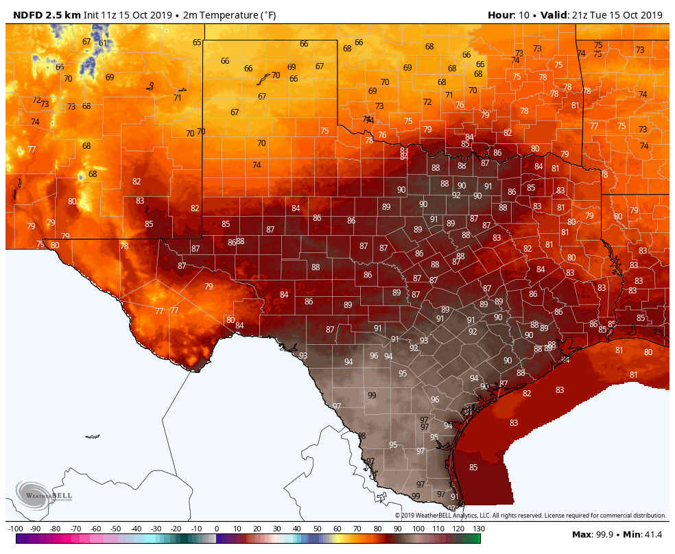
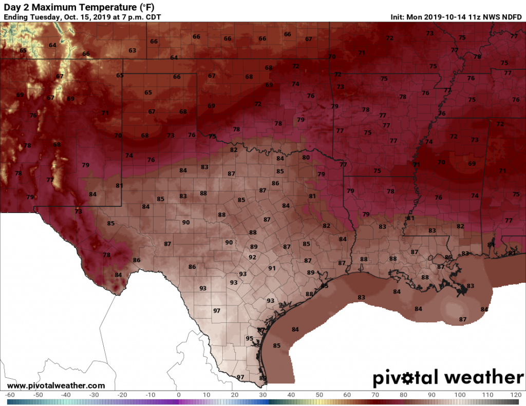
Soupy, warm weather remains in Houston until Thursday’s front

Dense fog is again the story this morning, as very warm air temperatures in the mid-60s overrun run nearshore sea surface temperatures 10 to 15 degrees cooler. It will take some time for the fog to burn off, perhaps not until late morning for some areas. We can expect foggy mornings (and nights) through Thursday morning before a cold front snaps the region back into more seasonal temperatures.

Tuesday and Wednesday

The next two days should more or less be carbon copies of Monday, with high temperatures in the mid- to upper-70s and lows only falling into the 60s. Some very light, very scattered showers are possible both days, but for the most part we should just see clouds. Perhaps the only notable change will be an increase in southerly winds on Wednesday, as lower pressures over the central United States bring winds up to 15 or 20mph.

We don’t expect too much rain with this week’s cold front. (Pivotal Weather)

Thursday

A cold front remains on track to push through Houston on Thursday, likely during the middle of the day. Rain chances will increase Wednesday night and Thursday morning ahead of the front, but again, accumulations don’t look too serious, with most parts of the area perhaps picking up two or three tenths of an inch. A few brief-lived thunderstorms will be possible. By Thursday afternoon or evening, rains should end as much colder and drier air blows in, bringing nighttime lows into the low 40s for most of Houston.

See full post

Fog, gray skies, and then more gray skies in the forecast

As Matt noted Friday, we’re in the midst of “fog season” in Houston, when warmer air moves over the somewhat cooler nearshore coastal waters, bays, and inland waterways. Much of the region saw fog this weekend, and it is especially dense this morning, with visibilities down to one-quarter of a mile, less for some areas. The fog should slowly begin to dissipate this morning with the rising sun. We’ll likely see fog of various densities through Thursday of this week before a strong cold front moves through the area.

Monday, Tuesday, and Wednesday

Aside from the fog, there isn’t too much to say about the region’s weather through the middle of the week. Days will be warm, with highs in the mid-70s, under mostly cloudy skies. Nights will be especially warm, with the cloud cover and moderate southerly air keeping lows in the mid-60s. This is about 20 degrees above normal for this time of year.

Lows Wednesday will be in the mid- to even upper-60s for parts of Houston. (National Weather Service)

Rain chances aren’t going to go away completely, but each day will only have about a 10 to 30 percent chance of rain, and any precipitation that falls should be light. Accumulations through Wednesday should be on the order of one-tenth of an inch for most locations.

See full post

Houston will experience spring-like conditions for the next week

January comes to an end today, and overall it has been a more or less typical winter month. Temperatures are going to end within a few tenths of a degree of normal, and rainfall totals will for the most part be slightly above normal. February, however, will start on a much warmer note—with spring-like days and much warmer nights. Winter won’t return until about a week from now.

Most of the Houston area received 3 to 6 inches of rain this month. About 4 inches is normal for January. (National Weather Service)

Thursday

In addition to warmer weather, we’re now going to return to a wetter pattern without high pressure to shut rain chances down. Today, especially, should see some healthy rain potential as low pressure moves up the Texas coast. Chances will be best to the southwest of Houston, near Matagorda Bay, but coastal areas of the Houston region will also see a solid 50 to 70 percent chance of rain, with lesser possibilities inland later today. Accumulations should only be a few tenths of an inch. Cloudy skies should keep highs to about 60 degrees, with lows tonight only falling a few days off of daytime highs.

See full post

Houston feels 100 degrees warmer today than the Midwest

Temperatures are generally in the low 40s across Houston this morning, ranging from 41 degrees at Bush Intercontinental Airport to 45 in Galveston at 6:15am. If, when you step outside, you think, “Oh this feels a bit chilly,” you might pause for a moment to consider the Midwest. The following map shows “wind chill temperatures” for the region this morning, and some of them are nearly 100 degrees colder than the air temperature in Houston. For example, Chicago has an air temperature this morning of -22 degrees, but with westerly winds of about 20 mph, the wind chill at O’Hare Airport is -49 degrees. Parts of Minnesota are near -60 degrees.

Wind chill temperatures at 6a.m. Wednesday in the Midwest. Click to zoom. (Space City Weather)

Wednesday

Today will be the last day that Houston sees long stretches of sunshine for awhile, before a warmer, grayer, and at times wetter pattern descends on the region. With partly sunny skies, we should see highs today climb into the mid-50s, and mostly cloudy skies tonight should keep lows in the mid- to upper-40s. After this, say bon voyage to winter for nearly a week.

See full post