Good morning. Just a quick note before today’s post—I wanted to say thank you to the 250 or so people who came out to the Houston Museum of Natural Science on Tuesday evening to hear Matt and I talk about the site, weather, hurricanes, and more. It was wonderful to meet so many of you, especially the two lovely young women who read this site to their mom every morning for practice—I’ve forgotten your names, and I’m truly sorry—but I promise to keep everything PG!
Wednesday
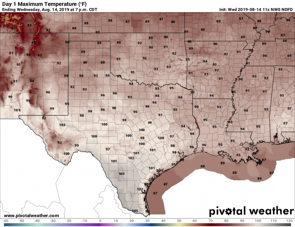
Change is coming slowly to Houston, but we’re still going to see another very hot day. The city has now recorded six consecutive days of 101-degree temperatures, and I don’t quite think we’ll get there today. But a heat advisory remains in effect, and we’ll at least get into the upper-90s if not 100 degrees.
Texas highs should generally be 2 to 5 degrees cooler than they were Tuesday. (Pivotal Weather)
Nevertheless, change is on the way, with high pressure finally beginning to back off to the west. This should allow for a fairly healthy—40 or 50 percent?—chance of showers late this afternoon and evening as the sea breeze migrates inland and collides with a disturbed atmosphere moving south. For the most part accumulations will be measured in the tenths of an inch, but a few heavy thunderstorms may drop more. Lows tonight will still be in the 80s.
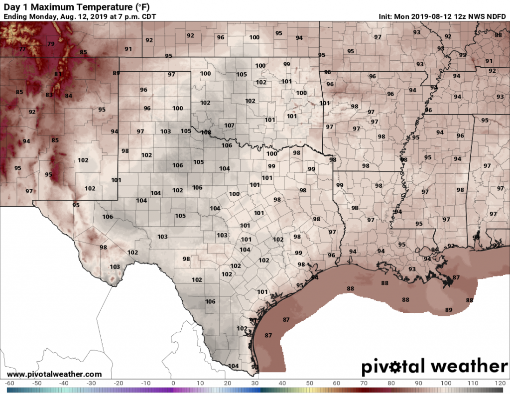
Houston endured its sixth consecutive day of a 101-degree high temperature on Monday, and the region may well have one more today before some relief finally arrives in the form of a weak front. There won’t be much cooler air, but clouds and rain chances will help moderate temperatures as high pressure eases off to the west.
Tuesday
But not today. Once again, Houston will bake beneath triple-digit heat on Tuesday and mostly sunny skies. Very light southeast winds will offer almost no relief, and Tuesday night’s lows will again be around 80 degrees for much of the region. Needless to say, a heat advisory remains in effect. The only good news from a weather perspective? August is almost half over.
Tuesday’s highs are, in a word, ugh. (Pivotal Weather)
Wednesday
As high pressure backs off to the west, a weak front will move southward into the state. Depending on the timing, this will either limit highs to the upper 90s, or mid 90s—still very hot, but not as hot as we’ve been. Clouds will increase some, and rain chances will bump up to about 40 percent during the day and overnight hours. We aren’t expecting anything spectacular in terms of accumulations, but anything will be welcome after an extremely hot and dry week.
The region’s streak of very hot days and record-setting nights continues as high pressure dominates Houston’s weather. Here are a few notable trends from the last week across the region.
Bush Intercontinental Airport recorded four consecutive days of 101-degree high temperatures through Sunday.
Galveston has had six consecutive days in which overnight lows have only fallen to 84 degrees, the second longest streak after the heat wave of 2011.
Houston’s Hobby Airport set or tied its record low temperature on August 7, 8, and 9 with lows of 80 or warmer.
All of these trends are likely to continue Monday and Tuesday as the ridge of high pressure continues to dominate our weather. Fortunately, the pattern should begin to change by the middle of the week.
Texas will bake again on Monday. (Pivotal Weather)
Monday
A few, isolated areas of Houston saw some brief showers and thunderstorms on Sunday afternoon, as rising moisture was able to combat subsidence in the atmosphere. We may see a similar pattern today, with 10 to 20 percent of the region seeing brief showers. Any relief from the heat will be temporary, however, as we still expect a hot way with much of the area seeing 100 degrees. Nighttime lows will again be around 80 degrees for most of the area.
On Wednesday, officially, Houston came awfully close to 100 degrees. The temperature at Bush Intercontinental Airport spiked up to 99 degrees during the afternoon. Previously this summer, the high temperature had topped out at 97 degrees on several days. With high pressure now firmly in control of our weather, we can probably expect to hit the century mark today, or almost certainly in the coming days.
Thursday
A heat advisory is in place for today, with high temperatures likely in the upper 90s to 100 degrees, and the heat index—which factors in humidity—potentially reaching 110 degrees. Please take extra caution with mostly sunny skies, and very light southerly winds. We can’t entirely rule out a few stray showers and thunderstorms along the sea breeze, but precipitation is unlikely.
Friday, Saturday, and Sunday
The weekend will see more of the same, with highs likely to reach 100 degrees for inland areas, sunny skies, and warm nights with lows only falling to around 80 degrees. This is mid-August for you.
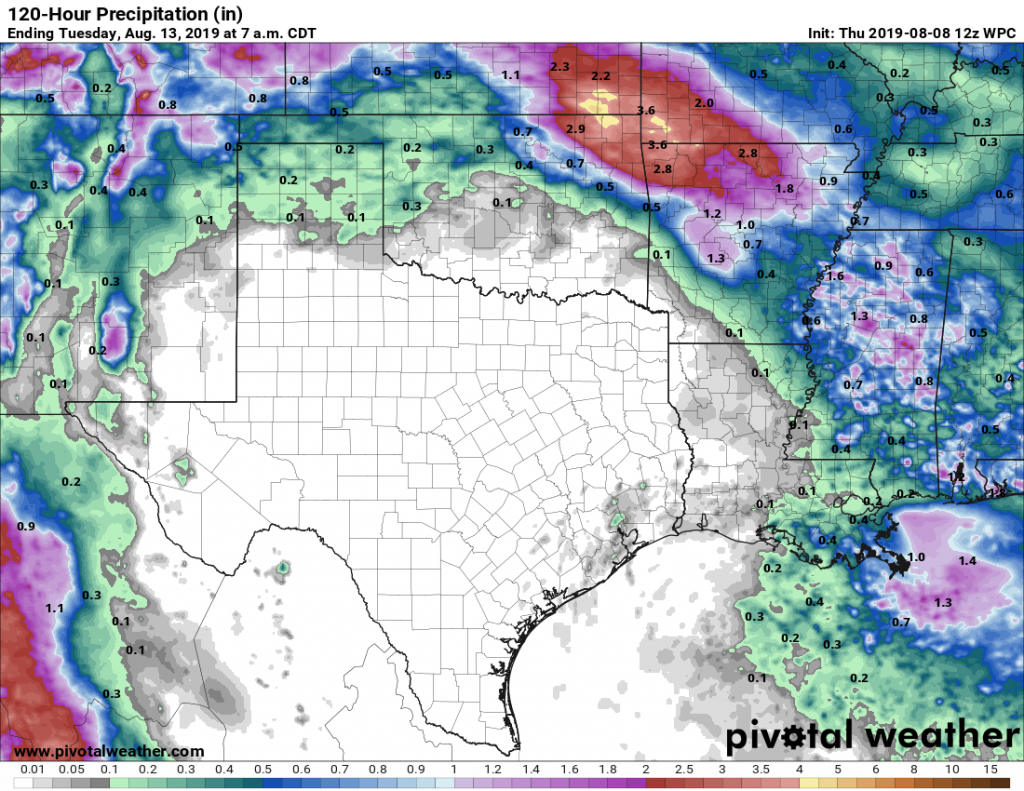
DRY TEXAS: Rain accumulation forecast for now through Monday. (Pivotal Weather)
Next week
The heat will likely continue for the first couple of days next week before the high pressure dominating the region’s weather pulls back to the west. This may allow for a more northeasterly flow, some slightly less hot air, and perhaps some slight to moderate rain chances.
Energy saving tips from Reliant
As temperatures push up toward the century mark, we all will be tempted to crank up our air conditioners. Reliant is here to help and remind readers about the benefits of saving energy, for both your electric bill and the state’s power grid.
Check out these energy efficiency tips and tools that could help you save energy and lower your electricity bill. Most of these tips are simple enough for anyone to do, like increasing the temperature on your thermostat a few degrees and avoiding heat-generating activities like using the oven or dryer in the afternoon hours.
If you’re a Reliant customer, you can track your electricity usage alongside daily temperatures with the Reliant app for iPhone or Android (you can also find Space City Weather linked there). Plus, you can set personalized alerts for electricity usage, bill estimates and more.
Reliant also has a cool program that rewards customers for making small changes to conserve energy during periods of high electricity demand. Customers can earn bill credits through the Degrees of Difference program when they cut down on energy usage during reduction requests, which helps reduce the load on the Texas electricity grid. Click here to learn more and sign up.
Remember you have a few more days to enter to win a new AC from Reliant by clicking here or share the link with someone in need. The deadline is August 13.

