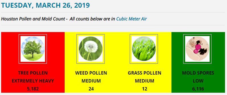
A year ago, Houston was under water

I can remember this morning, from a year ago, with crystal clarity. The Houston region had just seen its most intense night of rainfall, ever, as three major bands of rainfall swept across the city and flooded everything. Conditions grew so dire that the National Weather Service essentially invented a new warning to characterize flooding across the region, declaring a “Flash Flood Emergency for Catastrophic Life Threatening Flooding.” And it had only just begun, with the Houston region facing three more days of heavy rainfall.

(Space City Weather)

On this anniversary of Harvey, I invite you to share your memories with the Harvey Memories Project, a partnership between Rice University and local libraries. The goal is to create a digital archive of photos, short video, and audio of Harvey experiences. Local health researchers are also collecting information about the health, housing, and vehicle damage from Hurricane Harvey, and you’re encouraged to participate in this survey. Now, onto the forecast.

Monday and Tuesday

We’re in the midst of a pattern shift, as the high pressure that dominated Houston’s weather last week moves away from the region. This will lead to better rain chances this week, although perhaps not right away. Rain accumulations will generally be better for central and coastal parts of the region, rather than areas to the northwest, but overall most people should pick up some much needed precipitation this week.

For Monday and Tuesday, we’re probably going to seen only isolated to scattered rain chances, with 20 to 30 percent of the area seeing showers. High temperatures will depend on the extent of localized cloud cover, but probably will range from about 90 degrees to the upper-90s for areas that see full sunshine.

See full post

A heat advisory to end the week, a year ago Harvey becomes real

It’s August in Houston, so it should be no surprise that Houston’s weather is doing August things. After temperatures hit 99 degrees on Wednesday, we can expect more very warm weather to end the work week. Meanwhile, a year ago today, Harvey’s rainfall threat was becoming very, very real.

Thursday and Friday

The National Weather Service has issued a heat advisory for Thursday, and likely will extend it for Friday, as high temperatures are likely to reach 100 degrees, with a heat index of 105 to 110 degrees. These days will basically be a lot like Wednesday, with mostly sunny skies, hot days, and warm nights with lows in the upper 70s to 80 degrees.

A heat advisory is in effect for Texas along the I-10 corridor today from central Texas through Houston. (Pivotal Weather)

Saturday

Another very warm day, but as high pressure begins to slide away to the northeast, we’ll see some slight rain chances return to the forecast. If you have outdoor plans, I wouldn’t worry too much. I still anticipate mostly sunny skies, and high temperatures in the upper 90s. It’s just that we can’t rule out a few isolated to scattered showers moving through the area during the late morning and afternoon hours.

Sunday and Monday

Still very warm, with temperatures in the mid- to upper-90s, but as high pressure recedes a little more, I anticipate rain chances to nudge up to 20 to 30 percent. Skies should remain at least partly (if not mostly) sunny for both of these days.

See full post

Houston returns to 100s, a year ago Harvey emerges as a threat

A cold front will slowly move through Houston today, but the cruel reality of this in August is that drier air generally just means warmer days as high pressure builds in behind the front. And that’s just what we’ll see. At the end of today’s post we’ll also take a look at our forecast for Harvey a year ago, when the system still had not formally re-developed into a tropical storm, but clearly had become a rainfall threat.

Wednesday, Thursday, and Friday

With high pressure over head, slightly drier air, and mostly sunny skies the Houston region will see ideal conditions for daytime heat to end this work week. Expect high temperatures of around 100 degrees, give or take, with overnight lows in the upper 70s. This is classic August heat.

Have yourself some August heat today, Texas. (Pivotal Weather)

Saturday and Sunday

By later Friday or Saturday morning, the high pressure should have moved sufficiently off to the northeast to allow more moisture to move in from the Gulf of Mexico. The net effect of this will be to bring some clouds into the region and bring temperatures down into the mid-90s. We’ll also see some isolated to scattered showers, most likely during the afternoon as the sea breeze moves inland. 

See full post

A look ahead at high heat, a look back at Harvey a year ago

Ahh, you’ve got to love August in Houston. This is a month when a “cold” front actually means warmer weather, 100 degree days happen not too infrequently, and we face the threat of hurricanes. Today’s post will address all three of these issues, including a look back at this time, last year, to see what we were saying about the approach of Hurricane Harvey.

Tuesday

A dying cold front is north of the Houston area this morning, but should slog through the area today. The net effect of this should be to produce some scattered showers later today and this evening, and some of the embedded thunderstorms could produce briefly intense rains and winds. The chance of rain today is only about 40 percent, but that’s significantly higher than during the rest of the week. Despite the rain chances, for the most part, this should be just another hot and partly sunny August, with high temperatures in the upper 90s to 100 degrees.

Wednesday will be a hot one in the Houston area. (Pivotal Weather)

Wednesday and Thursday

Some drier air will move in behind the “cold” front, and along with this some higher pressures will build over the region. In August, this means just one thing—some serious summer heat beneath sunny skies. We can expect high temperatures in the vicinity of 100 degrees, perhaps even up to 102 or 103 degrees. The drier air may knock a tad of the humidity out of the air, but it’s still going to be extremely warm out there during the daytime. Please do take precautions, especially for any children participating in outdoor sports practices after school.

See full post