Temperatures in the upper 30s possible Sunday for northern Houston

After a cool morning we’ll have a couple of warm days before Friday’s significant cold front barrels through Houston.

Today and Thursday

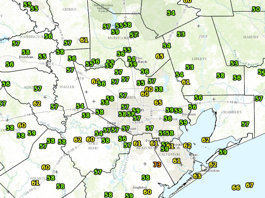
It’s going to be warm. After a dry, cool morning to start Wednesday off, with low temperatures in the 50s, southerly winds are going to bring humidity levels up for today and Thursday. Expect high temperatures to again reach into the low 80s, with the big difference being lows. Tonight they will likely fall into the mid-60s, and on Thursday night we’re probably stuck with a low of only about 70 degrees. Ewww.

Friday

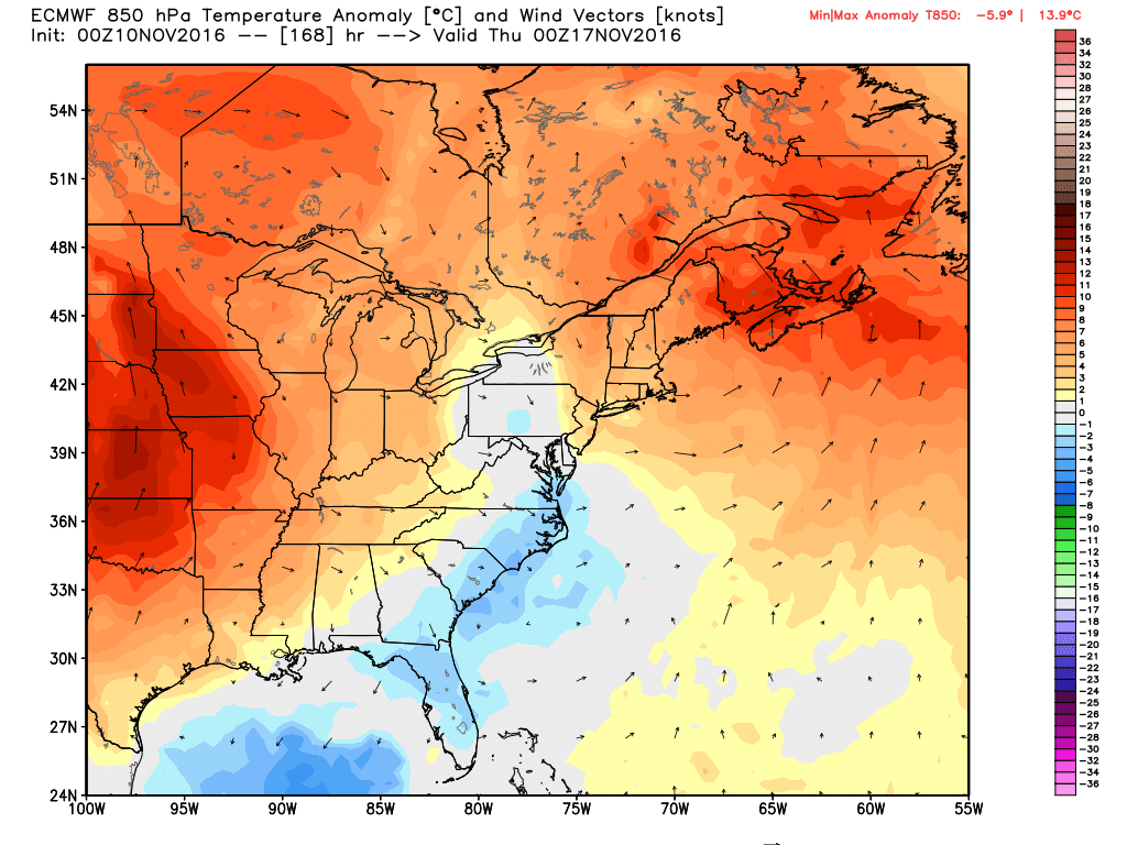
But it’s not going to last. A cool front should push through Houston sometime during the morning or early afternoon hours—right now sometime just before noon seems most likely—and along with it we’re likely to see a decent amount of rainfall. The forecast models have become more bullish, so we could see some fairly heavy showers along with the front’s passage. I still think most of the area will receive less than an inch of rain, but some isolated areas could pick up a few quick inches of rain. It’s something we’ll be watching for as the higher resolution forecast models start picking up on this.

Conditions should dry out and cool down by Friday evening as the front blows through.

The GFS model offers a snapshot of how low lows could go on Sunday morning. (Weather Bell)

Saturday and Sunday

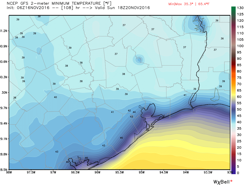
Look for a pair of gorgeous, sunny, fall-like days this weekend. Highs in 60s, lows on Saturday will be around 50 degrees, and will fall into the 40s for inland areas on Sunday. In fact, I would not rule out the upper 30s for northern Harris County, as well as Montgomery and Liberty counties.

Monday and beyond

Next week we’ll see a gradual warm up, with high temperatures likely getting into the mid- to upper-70s, before another front comes through. The timing is a bit uncertain, but it looks like the cooler weather should arrive a bit before Thanksgiving, potentially giving us highs in the 60s on the holiday. The front should bring another chance of rain on Wednesday or so.

Posted Wednesday at 6:20am CT by Eric

Houston’s weather warms a bit before a perfect fall weekend

Good morning. It’s a fairly mild morning across the region, with temperatures generally in the low 60s. Our forecast remains more or less the same with warming weather through Thursday, before a strong cold front arrives on Friday to chill us down for the weekend.

Today

Houston remains stuck between higher pressures to the west and lower pressures to the east. For today this should allow for a modest northerly wind which will keep our air a bit drier today. After a high temperature of about 80 degrees, we should see lows tonight around 60—lower for inland areas and a few degrees warmer closer to the coast. All in all it should be a nice, sunny day.

Wednesday and Thursday

These will be days where a lot of us are waiting eagerly for the front. I say that, because humidity levels will rise some, and temperatures could climb into the low 80s. Also on Wednesday, and especially Thursday night, lows won’t fall much. For some areas, Friday morning’s low might only bottom out at about 70 degrees. That’s sticky for mid November, but fortunately it’s not going to last. Both days should be mostly sunny.

The GFS model brings the front to the coast at noon, Friday. (earth.nullschool.net)

See full post

Houston warms later this week, but a strong front looms by Friday or so

It is a clear, cool fall morning across the Houston region, and although we will see gradually warming temperatures toward the end of the work week, another cool front will arrive by next weekend to keep conditions fall-like.

Temperatures at 6:15am CT across the region on Monday. (National Weather Service)

Today

Skies cleared this morning for great conditions to view the Supermoon, which set at 6:39am this morning. It will still look great tonight. Meanwhile temperatures will rise into the upper 70s today under partly to mostly sunny skies. Lows tonight won’t be nearly so cold, likely only falling to around 60 degrees for most of the region.

Tuesday and Wednesday

The region will receive another shot of drier air on Tuesday, and this combined with full sunshine will allow temperatures to reach about 80 degrees. But because it shouldn’t be excessively humid, it will feel quite pleasant outside. Lows will range from the upper-50s to lower-60s.

Thursday

As high pressure builds over the Houston we’ll see the return of more humid conditions beginning later on Wednesday and into Thursday. Highs Thursday should be in the low-80s, and I wouldn’t expect lows to fall much below 70, if at all, on Thursday night and Friday morning. Under partly to mostly cloudy skies it will feel quite humid. But this return of wamrer weather will be short-lived.

Friday morning's low temperatures will be 10 to 12 degrees above normal. (Weather Bell)
Friday morning’s low temperatures will be 10 to 12 degrees above normal. (Weather Bell)

See full post

Houston’s weather mostly sunny, and pleasantly cool through the weekend

As promised temperatures are clear and cool this morning across the Houston metro area, ranging from the low 50s northeast of the city to low 60s right along the coast, in places like Galveston Island. This is how it will be for awhile, so enjoy!

Houston area observed temperatures at 6:30am CT.  (National Weather Service)
Houston area observed temperatures at 6:30am CT. (National Weather Service)

Today

With primarily northeasterly winds we’ll continue to see drier air move into Houston. We’re seeing this flow in response to a large, upper-level low pressure system in northern Mexico, to the southwest of our region. It should allow skies to clear some later today, but keep high temperatures in the lower 70s. One consequence of this northeasterly flow will be higher tides along the Texas coast, perhaps as much as three feet above normal. the National Weather Service says.

Friday and Saturday

Conditions will remain more or less the same heading into the weekend, and we will certainly have fitting weather to mark Veterans Day. Look for partly sunny to mostly sunny skies both days, with highs in the mid-70s, and lows in the 50s except for along the coast. Hard to beat that as we show appreciation for those who serve in the US military.

Temperatures may warm back to a few degrees above normal later next week. (Weather Bell)

See full post