For the month of December, Space City Weather has been sponsored by The Law Office of Murray Newman. This means the site was provided for free, without advertising, for the entire month thanks to Murray.
Here’s a bit more about him, and the legal services he provides:
I’m a former Felony Chief Prosecutor who practices Criminal Defense in Harris County and the surrounding areas. I’m an 1995 graduate of Texas A&M and a 1999 graduate from the University of Houston Law School. I represent people accused of crimes, both misdemeanor and felony. I’m a trial lawyer who doesn’t back down on even the toughest of cases.
Thank you to Murray for supporting the site this month!
The high on Christmas Day in Houston was 54 degrees, and on Tuesday the high only reached 51. Nevertheless, those days will feel balmy compared to the next two days, when high temperatures probably won’t climb out of the 40s. After a slight warm-up this weekend, we can expect potentially even colder weather next week.
Wednesday
Very light rain is falling across the southern half of Houston, and this activity should slowly push offshore this morning. But that doesn’t mean the Sun is going to grace us with its presence. No, instead we’ll be left with a cloudy, gray day with highs in the mid-40s. The coldest day of the year came on Dec. 8th (44 degrees) and we may tie that today.
Do not be alarmed if you see this in the sky on Friday.
Thursday and Friday
Moisture levels fall a bit, but I don’t think we can completely rule out a bit of drizzle during Thursday and Friday mornings. Thursday will remain cloudy, with a high of near 50 degrees, and Friday might actually nudge up into the mid-50s. Houston might also see the Sun for a time on Friday—please don’t be shocked when you see a big, bright, yellow orb in the sky. Nighttime temperatures will remain comfortably above freezing.
We hope everyone enjoyed the Christmas holiday. For kids, the two week winter break has just begun, while for many others its back to work today. Weather wise, we are looking at a cold, and often damp forecast to end 2017 in Houston.
Tuesday
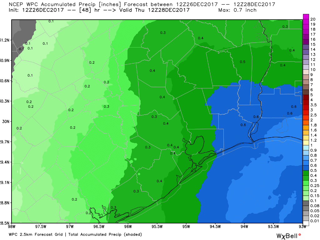
This morning has started out cold and gray, and conditions won’t change much throughout the day. The radar shows drizzle and light rain showers spreading out over the region, and this will remain the story for much of today and tonight. We won’t see much in the way of accumulations—with a tenth or two of an inch of rain on the west side of Houston, and perhaps as much as half an inch through Wednesday morning. Temperatures will remain cold, with gray skies limiting highs to around 50 degrees. Lows tonight will drop into the 40s.
Through Wednesday, rain accumulations should be greater to the east of Houston than the west. (NOAA/Weather Bell)
Wednesday
A cold front will push through the Houston region later on Tuesday or during the overnight hours, and this should bring some marginally drier air. Eventually, this drier air should allow for rain chances to end Wednesday. Even where it does rain Wednesday, accumulations should be slight. The main story will continue to be temperatures, with highs Wednesday likely remaining in the 40s—chilly.
Good morning. We are now just one week from Christmas, and there are still some key uncertainties in terms of both temperature and precipitation. We’ll break it down below, but the bottom line is that the last week of 2017 does look quite cold.
Monday
For the first time since Dec. 4, overnight lows didn’t cool down much on Sunday night for most of the city of Houston except northern areas, and lows this morning are generally only down around 60 degrees. Under cloudy skies, don’t expect too much of a warm up with highs in the upper 60s or around 70 degrees. Most of the area should also see at least some light precipitation today, with accumulations of a few tenths of an inch. We don’t anticipate heavy rainfall expect possibly for areas far to the northwest of Houston.
Tuesday
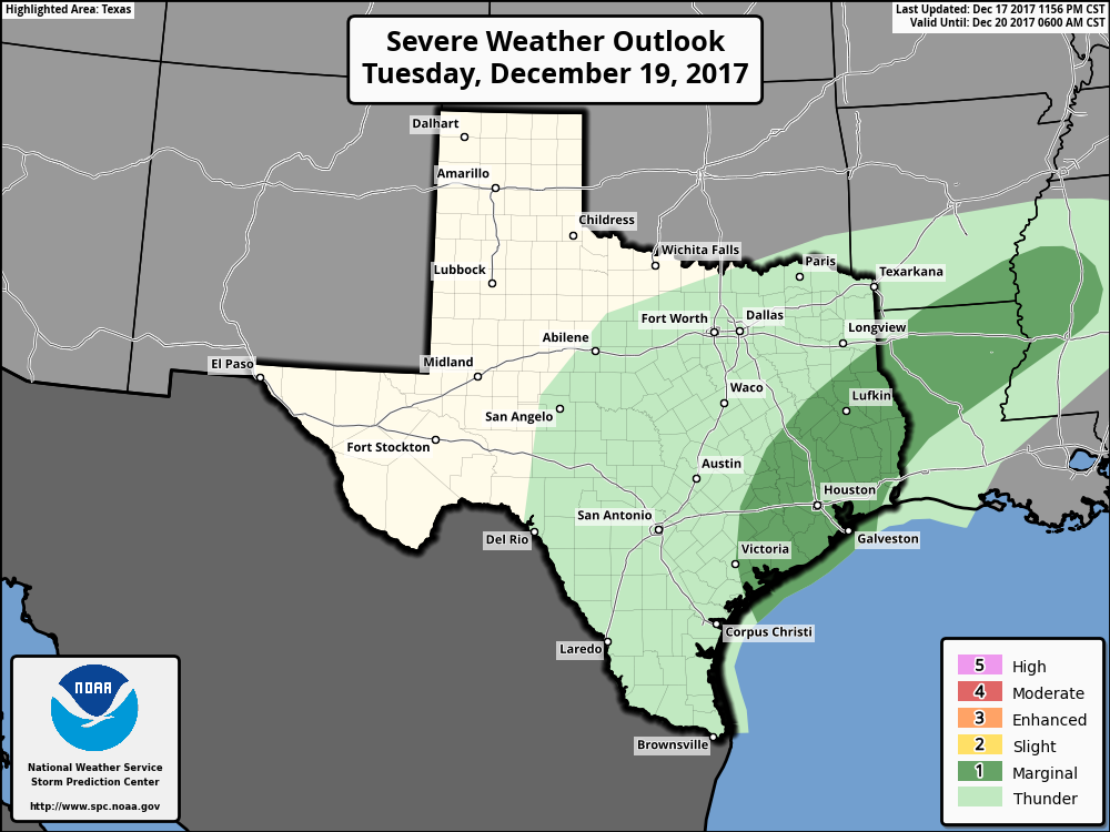
The region’s warm and muggy weather will continue on Tuesday, with a warm night again only down in the low 60s. We’ll also see a decent chance of rainfall during the day and evening hours, especially for inland areas.
Severe weather outlook for Tuesday and Tuesday night. (NOAA)
If you live on the inland side of Highway 59/Interstate 69, accumulations of 0.5 inch or greater are possible, but if you live closer to the coast you can probably expect less than that. A few strong thunderstorms may be possible area-wide later in the day (see the severe weather outlook), most likely during the afternoon or evening hours.