As a line of storms now approach Houston, reaching areas such as Katy and nearing Sugar Land, Tomball and The Woodlands, we’re starting to see some tornado warnings pop up across the region.
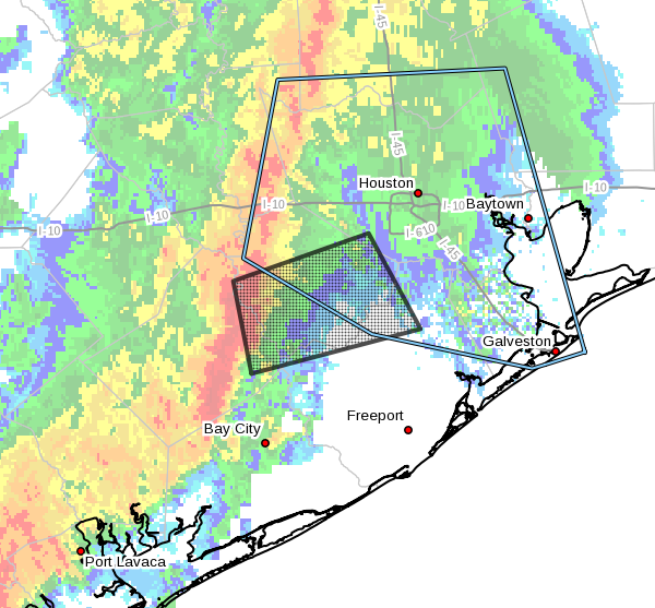
Most notably the National Weather Service has issued a tornado warning until 8:45am CT for parts of Northeastern Wharton County, Northwestern Brazoria County, South central Harris County, and Fort Bend County:
Area of tornado warning in effect until 8:45am CT. (National Weather Service)
These storms will continue to move from west to east this morning, and I expect this mess to clear out of the area by around Noon, if not before. In the mean time, however, be prepared for the possibility of tornado warnings throughout the metro area, during which you should take cover indoors, in an interior room if possible.
Good morning. As anticipated a cold front is approaching Houston from the west this morning, and will bring with it heavy rains, a tornado watch, and a chance of severe weather. You’ll need to pay close attention to weather conditions this morning. The storms will clear out this afternoon, and Houston will cool off for the remainder of the work week.
Today
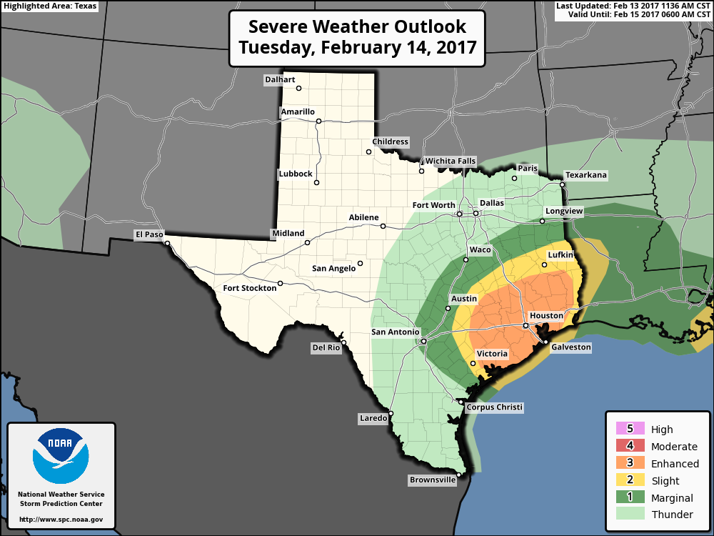
Due to favorable conditions for tornado formation, the National Weather Service has issued a tornado watch for the entire Houston metro area through 1pm CT today. One measurement of a storm’s potential to produce tornadoes is a parameter know as Convective Available Potential Energy, or CAPE, and values later this morning could run as high as 2000 J/kg in the Houston area. While this value is far from extreme, it means there will be enough instability for tornadoes to form. Tornadoes appear most likely between Interstate 10 and the coast.
Severe weather outlook for Tuesday. (NOAA Storm Prediction Center)
A line of storms should begin moving into western Harris County by around 7am CT this morning, and spread into most of the region by 8 to 10am CT. The most favorable conditions for tornadoes to form should be in place from around 8am to Noon. If your area falls under a tornado warning—issued when forecasters believe a tornado has developed and touched thr ground in a given area—please take shelter indoors, in an interior room, until the warning has ended.
The other primary threat from these storms this morning is heavy rainfall. Some of the heaviest storms could produce 1 to 2 inches of rain per hour, and isolated areas could receive as much as 5 inches of rain. While I don’t anticipate any home flooding, some streets in areas hardest hit could become briefly impassible later this morning and early this afternoon. Most areas will probably see 1 to 2 inches of rain, total.
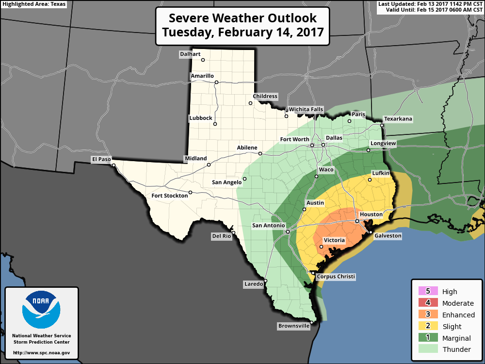
NOAA’s Storm Prediction Center has upgraded the risk of thunderstorms in Houston on Tuesday from “slight” to “enhanced.”
(NOAA/Storm Prediction Center)
This means the following for the Houston area:
Numerous severe thunderstorms are possible across the Houston region, with the greatest chance most likely along the Highway 59 corridor.
A few of these storms may be particularly intense, capable of spawning weak tornadoes, damaging winds or hail.
Some moderate street flooding is possible where thunderstorm training occurs, but for the most part these storms should move through at a good clip, from west to east.
The most likely time for storms will be from 10am to 2pm CT, with clearing likely during the late afternoon hours.
After a weekend of record-setting high temperatures—85 degrees on Saturday and 86 on Sunday—the region will cool down a little today, and a lot on Tuesday. The big concern, as noted my Matt, is the possibility of storms and severe weather on Tuesday afternoon.
Today
A very weak front will slowly move southward through Houston, and likely get hung up near the coast. This will create mostly cloudy conditions, and bring a chance of sprinkles to the area, but no major rainfall accumulations are likely. An easterly wind should help limit high temperatures to the mid-70s. Lows tonight will be in the mid-60s.
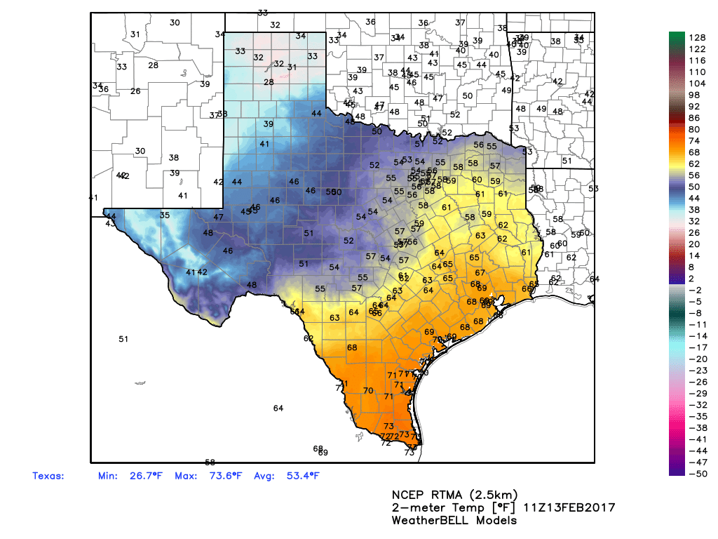
Temperatures this morning are in the upper 60s across the Houston metro area. (Weather Bell)
Tuesday
On Tuesday a stronger front will move through Houston, and with a deep source of moisture streaming in from the Gulf of Mexico we’ll likely see some rain showers and possibly some severe thunderstorms with the front. Given the setup it’s likely that most areas see 1 to 2 inches of rains from storms as the front passes through—probably between about 11am CT and 4pm CT on Tuesday. A few areas might see as much as 3 to 5 inches of rain, which could cause some street flooding problems.