We just wanted to offer up a quick update this morning to let you know that Invest 92L, or Potential Tropical Cyclone #2 has now been declared officially as Tropical Storm Barry in the Gulf.
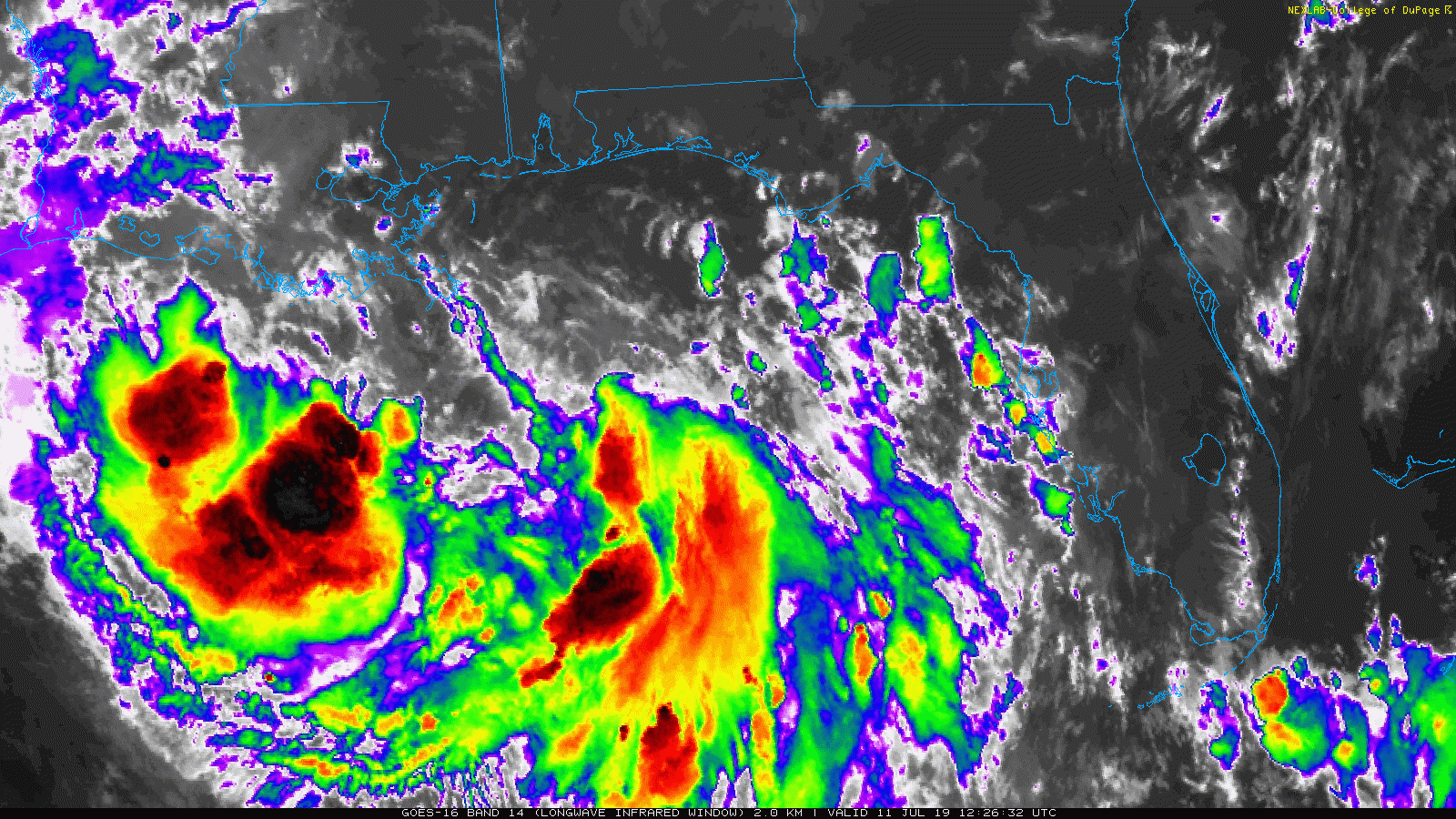
Satellite imagery shows a system struggling to consolidate, but it has organized enough to be classified as a tropical storm. (College of DuPage)
Maximum sustained winds are 40 mph as of the 10 AM CT National Hurricane Center advisory. The system is still struggling a bit to organize this morning, but now has a better defined center, enough so to be classified as a tropical entity. Most of the storms are displaced to the south and west of the center. Over the next 24 hours, the satellite presentation of Barry should improve, and slow strengthening should commence.
For us in Houston, the good news is that we remain outside the forecast cone, unlikely to see any significant impacts from what should become Tropical Storm Barry.
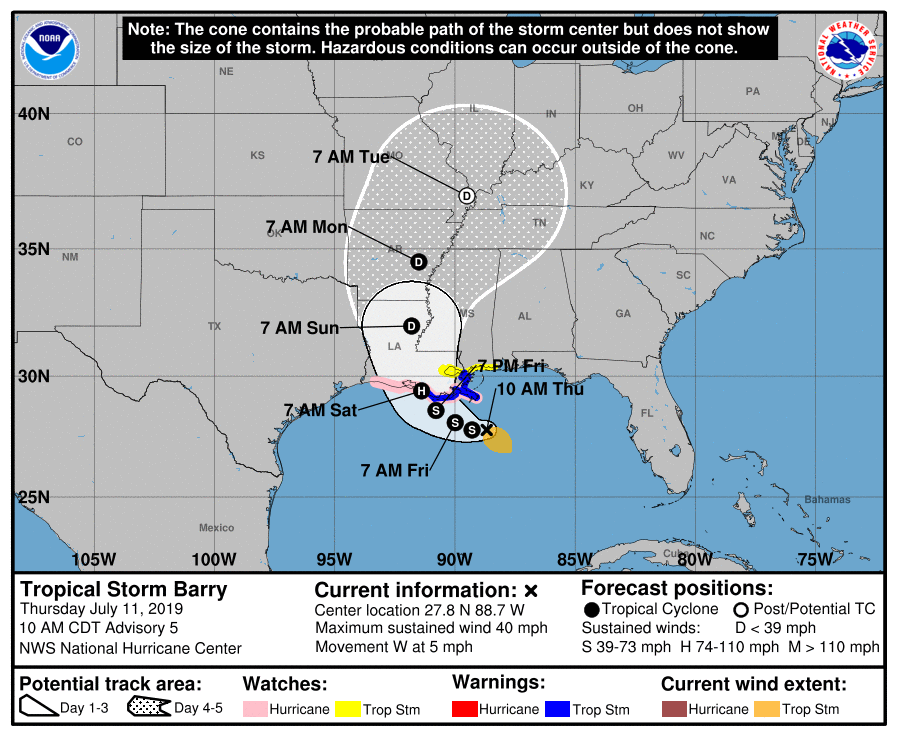
The National Hurricane Center forecast for Barry was nudged even a bit farther to the east this morning. (NOAA/NHC)
The National Hurricane Center is bringing Barry somewhere between Cameron & New Orleans on Saturday as a category 1 hurricane. Hurricane Watches remain hoisted from Cameron to the mouth of the Mississippi River. Tropical Storm Warnings are now up for the Louisiana coast east of Morgan City. For folks in Louisiana, this will be a tropical system, yes, but the main story will probably remain the rains that will fall, regardless if this remains a weak tropical storm or strengthens into moderate or strong tropical storm or hurricane. Those rains will all be capable of producing widespread flooding problems in the eastern half of the state and perhaps in Mississippi, should the storm shift any farther to the east.
Here in Houston, just keep tuned to the forecast, especially if you are traveling anywhere east of the region this weekend. Otherwise, expect some showers and storms to pop up this afternoon or evening. Some of the storms could be locally heavy.
So I just wanted to freshen up the site with a quick overview of what’s happening this evening and table set for tomorrow morning, when we should begin to give some more confident answers on impact risks to our area.
Now
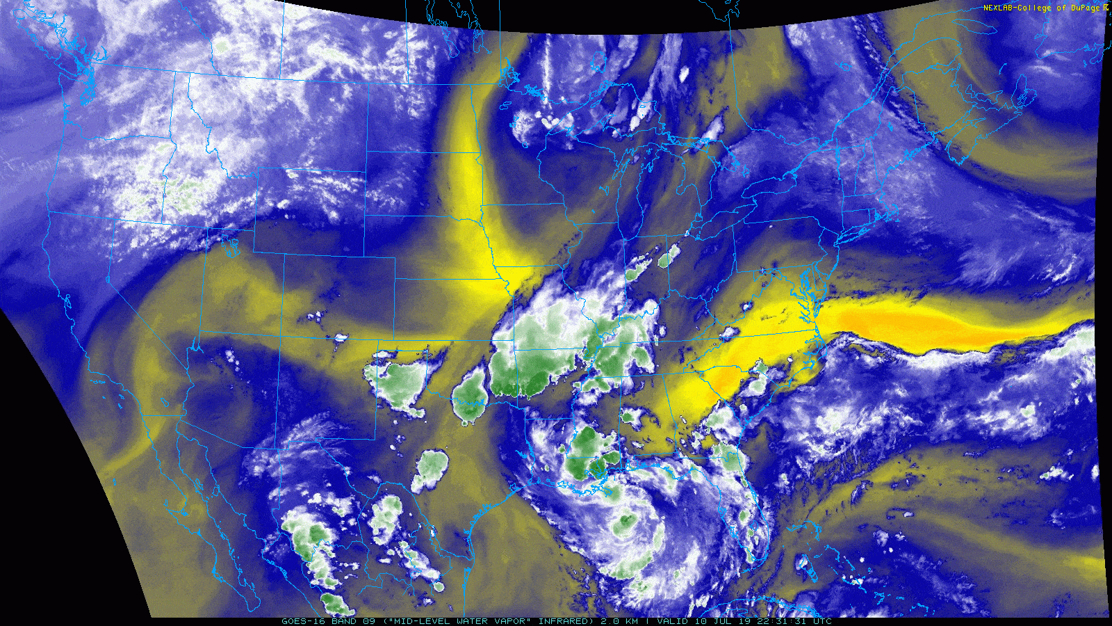
I want to point out some of the key features to watch on a water vapor satellite image.
A satellite loop of water vapor shows several features we will be watching. (College of DuPage)
First, over the Desert Southwest, you can sort of see yellow color lifting north slowly. That’s the ridge of high pressure which will play a role in steering presumed future Barry. To the north, over Minnesota and Iowa, the yellow color beginning to dig south and east represents a trough in the upper atmosphere that will act to try and “pick up” Barry, drawing it to land. The ballet between these features, combined with where the storm eventually coalesces will determine whether this is indeed a Louisiana storm, as most modeling suggests, or if it could make its way far enough west toward Texas. We will learn much more about this overnight.
Where is that center?
Well, according to this tweet from one of the hurricane hunters, it’s still too broad to be easily defined:
Based on the most recent observations from the aircraft out there this evening, however, they may finally be on to something near 27.5 N/87.5 W, or a little bit south and east of where the National Hurricane Center had been initializing things. If that is the case, that would not be drastically farther south than expected, meaning I would feel a smidge better about the “miss Houston to the east” scenario being realistic. That said, strange things can happen overnight, so let’s watch and see what’s what tomorrow morning.
Evening models
A new batch of modeling comes out in the evening that we don’t use a ton, but we can still use to look for trends. Indeed, those models did trend back to the west a bit, but not as far as it looked this morning. What does this mean? Model consensus is still very much pointing toward a Louisiana landfall, keeping most impacts to our east. Thus we have no issues with the official forecast from the National Hurricane Center.
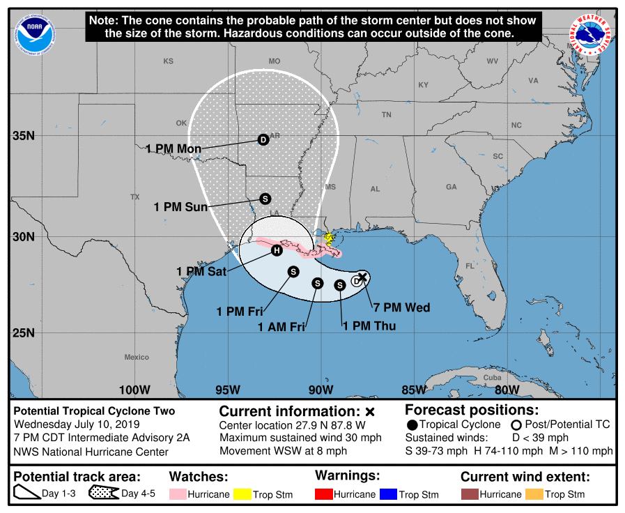
This evening’s forecast will be refreshed around 10 PM CT, and it may wiggle a bit to the east. (NOAA)
The NHC forecast for “Potential Tropical Cyclone Two” shows landfall between Cameron, LA and Vermilion Bay, but the cone obviously extends further to the eastern side of Houston on the left and east to near New Orleans on the right. Hurricane Watches were hoisted late today, extending from Cameron, LA east to the mouth of the Mississippi River. I would expect a tropical storm or hurricane watch to be extended west overnight, perhaps all the way to High Island, TX (northeast of Bolivar).
One word of note: If you have friends or relatives in the eastern half of Louisiana or your travels will take you through there between late Friday and Sunday morning, please make sure everyone is staying on top of the latest with this system. This has the potential to be a very serious rain and flooding event for that region, including Baton Rouge and New Orleans.
So for folks in Houston: You can go to sleep tonight knowing that no data this evening has increased our odds of being significantly impacted by this storm. But given a lingering degree of uncertainty, you absolutely will want to check back in on the forecast tomorrow morning to see what, if anything, may have changed overnight.
Eric has you covered in the AM, and I just want to offer him a mention of gratitude for stepping up to spell me so we can maintain continuous coverage through the storm.
Good morning. Let’s cover the next couple days, and then jump into the latest on the tropical system.
Today
It will be very hot once again today, with mid- to upper-90s likely across the region. Look for borderline heat advisory criteria once again, so be sure to take it easy if you must be outdoors. A stray downpour or slow moving storm is possible.
Thursday
Look for a more typical summertime afternoon tomorrow. We will likely hit the mid-90s before more numerous scattered storms pop up across the region. Some could produce heavy rainfall, though some parts of the area won’t see anything. Things should quiet down after sunset.
Friday, weekend, and future Barry
Let’s discuss the future of the Gulf disturbance, currently known as “Invest 92L,” or what should become Tropical Storm Barry tomorrow or Friday.
The one two sentence summary: Weather model data has shifted back a bit to the west with Barry, though the vast majority of output still keeps the center and worst impacts focused in Louisiana Friday through Sunday. Still, this would be close enough for at least some fringe impacts in Houston, and given that there is still some uncertainty, we cannot write off a further drift to the west, so be sure to check back in with us later today.
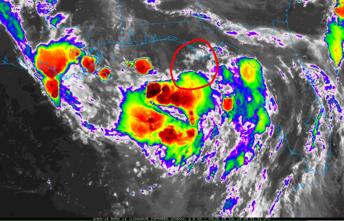
Now: The disturbance known as Invest 92L is over the Gulf, just south of Apalachicola, FL, or somewhere near the area I’ve circled in the satellite image below.
Invest 92L, or the system we are watching to likely become Barry, is broadly located somewhere just off the Florida Panhandle this morning, disorganized in nature. (College of DuPage)
Over the course of today, 92L will likely slowly organize itself and drift to the south. Where exactly this occurs will have implications on both future track and intensity, so today is a critical day to watch observations and changes in modeling. It is possible, if not likely, that the National Hurricane Center will begin issuing advisories on this today or tonight, tagging it as a “potential tropical cyclone.”
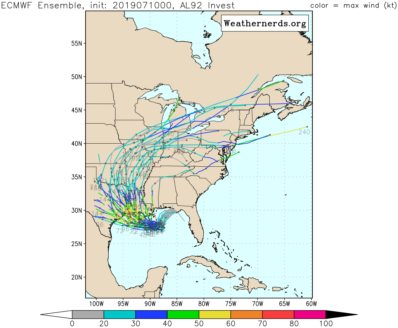
Track: As of this morning, model data has shifted the track of 92L, as it develops into Tropical Storm Barry further west. Yesterday, model consensus pointed toward a track west and then a quicker lurch north into the Vermilion Bay area in Louisiana. This morning, that consensus has shifted about 50 to 75 miles further west toward Cameron, Louisiana. Here is a map of all the European ensemble tracks from the 51 ensemble members. What does this tell us? It’s basically the European model run 51 times with different initial conditions. This offers you a broader range of possibilities and includes some fringe ones you might not consider if you just use operational modeling.
“Spaghetti plots,” as these are known can only tell us so much, and today they are telling us that the consensus in modeling has shifted a bit more to the west. Though the majority of modeling keeps this east of Houston, enough of a minority is still far enough west to keep our guard up and prevent us from saying that we’re “all clear.” (Weathernerds.org)
What we look for is trend and consensus. Yesterday, consensus was to the east of where it is today, so the trend is drifting back closer to us, meaning we need to remain aware of what this storm does. And there are still a handful of ensemble members that want to bring this even farther to the west and south. This is a very uncertain outlook at this time. Ultimately, the forecast track of future Barry is too close for comfort. Although we will hopefully gain more clarity on that later today, it will be important to make sure you have your plan and kit in place in case you need to act quickly beginning tomorrow. Hopefully this stays to our east and that’s that, but we cannot promise that and uncertainty remains annoyingly high, given recent trends.
Good evening. It’s just a wee bit hot out there this evening, so we hope folks are taking it easy. In this update, we will discuss the latest on the developing tropical system in the Gulf (Invest 92L or “Future Barry”) and what the latest model guidance has suggested.
One sentence summary: Our disturbance is finally heading into the Gulf and will spend the next 24 hours or so slowly figuring out where exactly it wants the center to form before heading west, which means there is still a good deal of uncertainty regarding the final outcome of this system.
Now
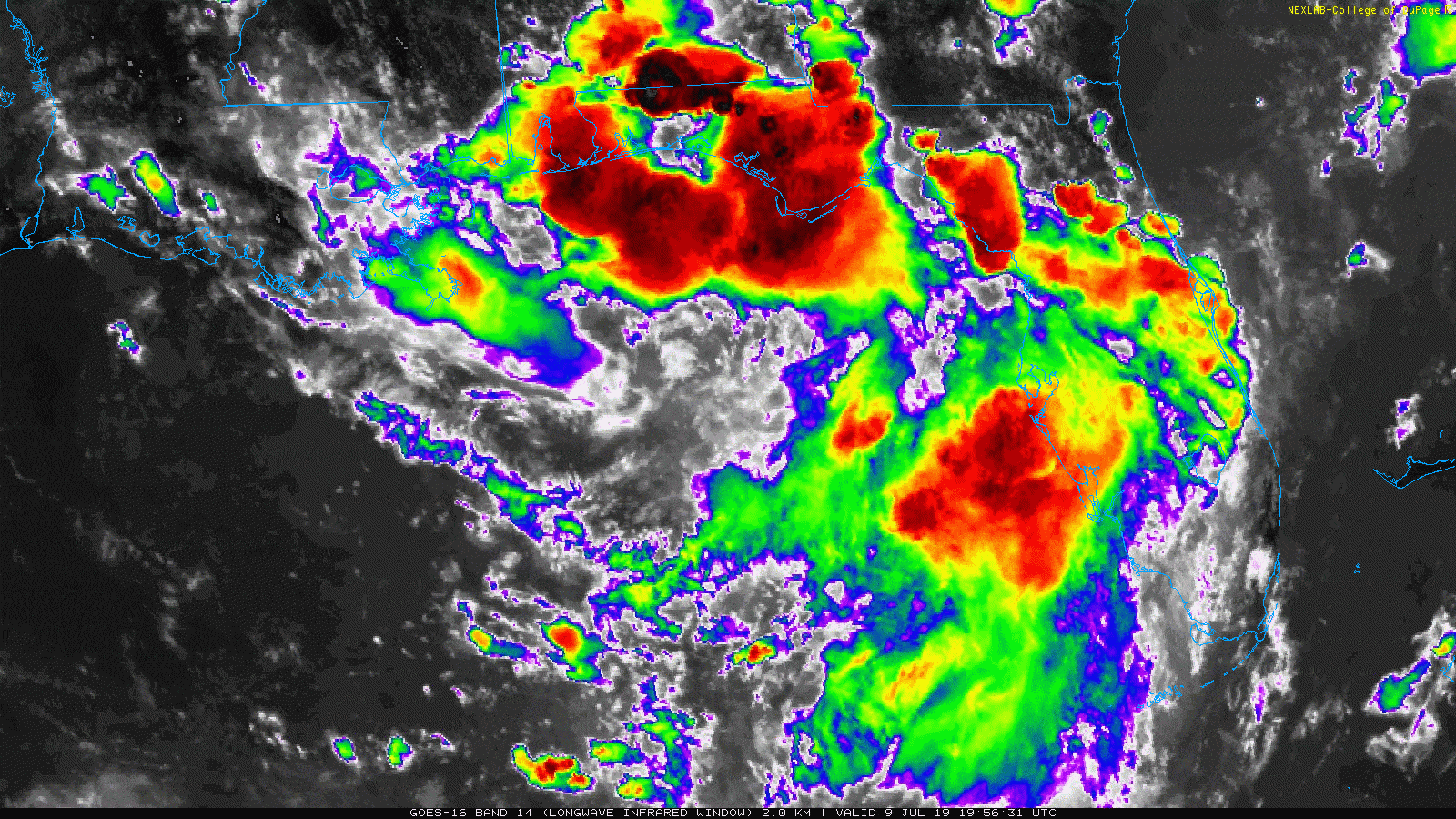
Invest 92L is somewhere over the Florida Panhandle or just offshore; there isn’t quite a defined center just yet. This is half the challenge with the forecast. We are relying on models to tell us where the center will form, not basing the forecast off an actual center. So there is some inherent uncertainty in the forecast because of this.
Invest 92L is far from organized this evening, but it is loaded with thunderstorms. (College of DuPage)
With that in mind, there are clearly plenty of storms along the eastern Gulf Coast, and these will slowly meander offshore tonight, allowing for 92L to figure out where it wants its center to form and how that relates to what is happening above it in the atmosphere. We should see a small uptick in track forecast confidence tomorrow morning, followed by perhaps a stronger uptick in confidence tomorrow afternoon.
Today’s modeling
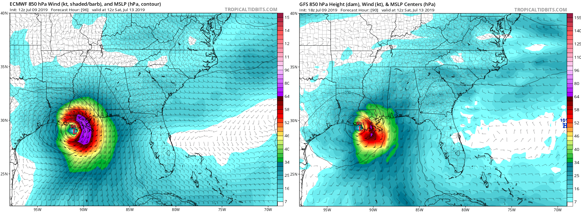
In a nutshell, the Euro held firm, while the GFS trended toward the Euro. Both deterministic models indicate a storm tracking toward and arriving somewhere between Jefferson County, TX and Vermilion Bay, LA. Should that actually happen, impacts in the Houston area will be minimal, but Louisiana would take quite a hit from rainfall and some wind at the coast.
The latest forecast for 92L, or Barry on Saturday morning is shown here, with the ECMWF (Euro) on the left and the GFS (American) on the right. Both deterministic models take this system to Louisiana as of today. (Tropical Tidbits)
But, as I have to hammer home: Deterministic models are never the right tool to use when making a 4 to 5 day forecast, particularly for tropical storms. You need to look at ensembles. As I did yesterday evening, here is a look at the European ensemble’s track density forecast from the University of Albany.
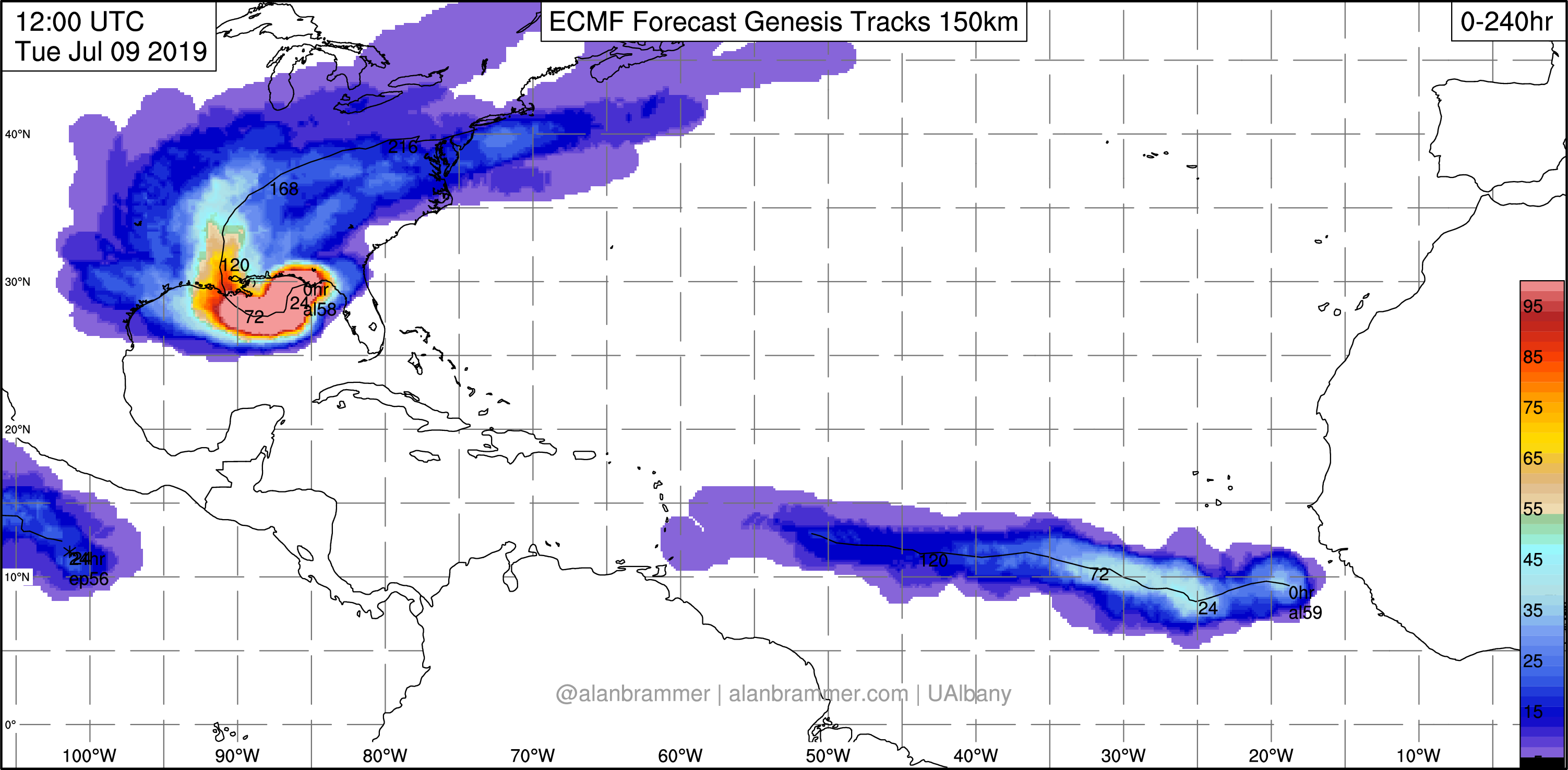
The European ensemble track density outlook favors a Louisiana landfall, but a notable minority of ensemble members still try to bring this to Texas. (University of Albany/Alan Brammer)
This takes the forecast tracks of the 51 ensemble members of the Euro and gives you a “spray” chart to see where clustering for higher confidence may occur, and we clearly see that something like 60 to 70 percent of the ensembles bring this toward Louisiana. But there is still a persistent, call it 20 to 25 percent minority of these ensembles that insist this will come to Texas. Until the center forms, and I can see what modeling is saying at that point, I want to be cautious about being too optimistic that we are going to miss out on impacts from future Barry.
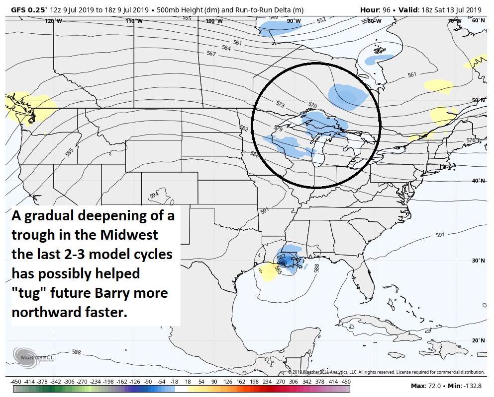
Why the faster turn north on the models today? Some of it may have to do with how 92L’s organization has gone so far, but some of it also likely has to do with the fact that over the last two to three model cycles, this trough over the Great Lakes and Midwest has trended a little stronger.
The upper air pattern has pointed to a stronger trough over the Midwest late this week, which may be aiding in trying to “pull” 92L/Barry more to the north than had previously been shown. (Weather Bell)
The stronger that trough is, the more ability it will have to “tug” 92L or Barry to the north. It may not necessarily capture it, but it could allow it to gain enough latitude fast enough to avoid a date with Texas or even western Louisiana. So that has been helpful for us. But again, until we know where that center is going to establish, we have to treat all individual model runs cautiously.
One final note: Weather modeling did shift a bit stronger with this system as it made landfall, which could indicate that while the ceiling on intensity for this storm may not be at an elite level, it could come ashore as a strengthening tropical storm or even low-end hurricane. So let’s hope that today’s track trends are accurate for us here in Houston.
So the bottom line this evening:
Invest 92L is gradually emerging in the northeast Gulf as expected. Over the next 24 hours or so, it will gradually develop a center of circulation that we can lock in on to allow us to gain forecast confidence on track.
Weather modeling held on to a shift to the east today, focusing the center and most impacts in Louisiana.
However, a notable minority of reliable data continues to cling to a potential further west scenario, closer to Houston. It’s because of this that we will be keeping our guard up until we get a sense of where the physical center of the storm is going to develop.
Modeling also trended a bit stronger with the storm, keeping the idea in play of a strong tropical storm or even low-end hurricane at landfall, regardless of where it goes; another reason to not yet call an all-clear.
We will have another update for you in the morning. Meanwhile, stay tuned in and vigilant and take one final opportunity to make sure your hurricane kits and plans are up to date, just to be safe.