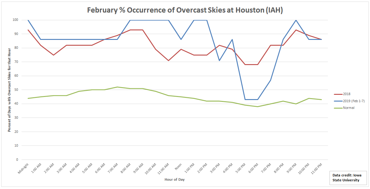
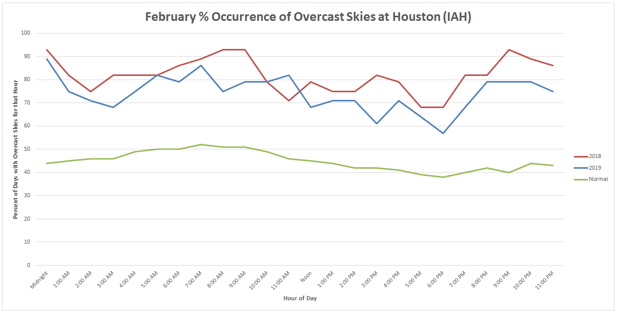
Wet weekend at times, tropics “noise” continues

Thursday saw another mixed bag of weather, with some folks seeing heavy rainfall and others seeing not much of anything. We should replay that program today before better odds of rain and storms return this weekend.

Today

Expect at least a handful of showers and thunderstorms today. Not everyone will get rain, but those that do could see some heavier downpours. In terms of coverage, it will probably be similar to or less than what we saw yesterday, with the best chances the closer you get to the coast. Today probably carries the lowest rain chances of the next several days.

Temperatures will range from the upper-80s where you see showers to the low-90s further inland with drier weather more likely.

Holiday weekend

We’ll see another disturbance about 20,000 feet up migrate toward us this weekend. What does that mean? It means gradually increasing rain and storm chances again. Saturday shouldn’t be a washout, but there will be a few more showers and storms than we saw yesterday and will see today. Sunday may be when the more widespread showers and storms impact us. Some of the rain on Sunday could be locally heavy. Additional widely scattered showers and storms will remain with us for Labor Day.

Rainfall through Sunday evening should average close to a half-inch, with higher amounts likely in spots, especially south and east of Houston. (NWS)

Best course of action this weekend? Have a rain plan ready to implement if you’ve got any outdoor activities. In some cases, you won’t need to use it, but given the erratic nature of rainfall in these setups, it would be good to have a plan to turn to. We don’t expect any serious flooding this weekend, but as is almost always the case in Southeast Texas storm setups, locally heavy rainfall could lead to brief, localized street flooding in areas of poor drainage.

Also worth noting, the tropical thunderstorms this weekend could be capable of producing funnel clouds or brief waterspouts, especially in the morning near the coast. Just something to keep in mind if you’ll be at the beach this weekend.

Expect temperatures in the upper-80s most days, with low 90s inland if rainfall doesn’t materialize quite as much as anticipated.

See full post

More of the same for Houston, a year ago Harvey acquires “the look”

Temperatures peaked in the middle 90s on Thursday, as we saw a little more morning cloud cover and a lot of haze than in prior days. Incidentally, the haze isn’t Saharan dust for a change. It is actually courtesy of the wildfires you’ve likely heard about in the news in the West.

An experimental forecast from the HRRR model, shows that as of 7 AM today, smoke will be prevalent over much of East Texas and Louisiana. (NOAA)

Expect somewhat poor air quality, with haze and smoke, along with elevated levels of ozone to impact the region through tomorrow. Air quality should slowly improve by the end of the weekend. Temperatures will not improve much unfortunately.

Friday and Saturday

It looks like we’ll be experiencing more in the way of typical August weather over the next couple days, but with very low rain chances. Folks will be lucky if they see an isolated downpour through tomorrow. Otherwise, it will just be hazy, sunny, and humid. High temperatures today and tomorrow should approach the upper-90s to near 100 degrees. Morning temperatures will be in the upper-70s, with a face full of humidity.

Sunday and Monday

Things change just a little here. I would expect partly to mostly sunny skies, with high temperatures generally in the mid-to upper-90s and AM lows again just under 80 degrees. The main difference between Sunday & Monday versus today and tomorrow will be a slight boost in rain chances. If chances today and tomorrow are 10 to 20 percent, chances Sunday and Monday will be roughly 20 to 30 percent. So, you’re still not necessarily likely to see any showers, but your odds are a bit higher here than they will be today or Saturday.

See full post

Next week’s cool front risk is tantalizing

The last couple days have featured a handful of showers in the area, but not much coverage. That said, those that have been fortunate enough to see rain have seen a fair bit. The next few days will likely see that as well, but your odds of seeing rain on any one day are rather low. Next week’s forecast is sitting out there like a piece of chocolate cake, daring you to take a bite. Tantalizing is the right word here. Let’s walk through things.

Today & weekend

We will see a lot of broken-record type weather this weekend, as Eric put it yesterday. It will be partly to mostly sunny and hot all three days. Look for high temperatures topping out in the mid-90s.

Just another typical August day in Texas with highs in the mid-90s for Houston today, hotter toward Austin and San Antonio. (Pivotal Weather)

Morning lows will be low-80s at the coast to mid- or upper-70s in Houston. Yes, as noted above, you could see a shower, but truthfully, I would expect most of us are dry this weekend. Saturday may have the very slight edge over Friday and Sunday for best rain chance.

A heat advisory was issued on Thursday for Houston and points south by the National Weather Service. I would not be shocked to see that happen again today, with high humidity rolling in with the sea breeze off the Gulf, driving unpleasant weather. Regardless, do exercise typical late summer heat precautions over the next few days, especially in the afternoon.

Monday

At this point, Monday looks like an extension of the weekend, with a slight shower chance and high temperatures in the mid-90s. There may be a slightly better chance of showers or storms than the weekend east of the area toward Beaumont and Port Arthur.

Basically, typical August weather through early next week.

See full post

A mostly quiet mid-August week ahead

Good Monday morning! Matt here this morning, covering for Eric. Thanks again to Eric for covering me in my opening days of fatherhood. Thanks to all for the comments and well wishes over the last couple weeks. I apologize for any typos, though I’ll blame it on the lack of sleep.

The Houston area has seen repetitive rounds of thunderstorms over the last week and change, but as someone who has been shut out most of the time, I’ve taken notice that the total rainfall distribution has been somewhat erratic.

Rain totals this month have been somewhat erratic around the region. (Harris County Flood Control)

Some areas have seen as much as three to five inches of rain this August, while others have seen a tenth of an inch or less. The winners appear to be in eastern Harris County and also up toward The Woodlands southwest toward Cypress. Waller County has done well also. So it’s been feast or famine for much of the region in August. Looking ahead to this week, the faucet will slow to a trickle for a couple days, and mostly typical August weather sets in.

Today & Tuesday

Our weather pattern has begun to change a bit, as high pressure and dry air begin to flex overhead. This should significantly limit storms in our area this afternoon. Expect high temps in the mid-90s. On Tuesday, we’ll see more of the same, though the rain chances may not be quite as limited. So, we’ll call it just a slight chance of showers. More mid-90s are expected.

There was a good bit of Saharan dust in the skies yesterday. Expect more of that today. Dust will slowly thin out on Tuesday and Wednesday. Air quality will be poor. This sort of thing will be worst for those with respiratory ailments. It’s also not optimal for those of us with regular seasonal allergies. The good news is that Saharan dust outbreaks tend to have peaked by now. So these events should become a little less frequent and intense as we move forward.

Wednesday through Friday

Typical August weather in Houston can be expected to round out the week. Temperatures will probably be one or two degrees cooler than usual, but that will hardly be noticeable to most of us. We’ll peak with highs in the mid-90s and lows in the upper-70s.

See full post