We managed our 4th straight 80 degree day yesterday in Houston, a feat last achieved in December of 2021. So, yay. I suppose. Congrats to those of you who like warm weather year-round. It’s your moment right now. Enjoy it because changes are coming next week, and we almost certainly have an end in sight to this warm pattern.
Today
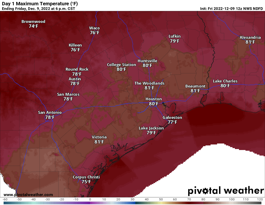
We expect a mostly similar day today to how recent days have been: Clouds, sun, fog in spots, especially near the coast, and highs around 80 or so. If Houston hits 80° again today, it will be only the fourth time we have had five consecutive 80 degree days in December, all of them coming since 1998.
Another day around 80 degrees seems likely today. (Pivotal Weather)
But today will also feature at least a chance of a few passing showers this afternoon. Most folks won’t see much of anything, but a few isolated pockets of rain are likely around the area.
Saturday & Sunday
We’ll have another warm night, with lows in the 60s and areas of fog, especially close to the coast. So Saturday may start a bit dreary, then perk up some. Highs will be in the 70s to near 80. Shower chances will once again arrive by late afternoon. Those chances will actually continue well into the evening or overnight hours. Lingering showers will be around on Sunday morning before things should subside a bit later in the day.
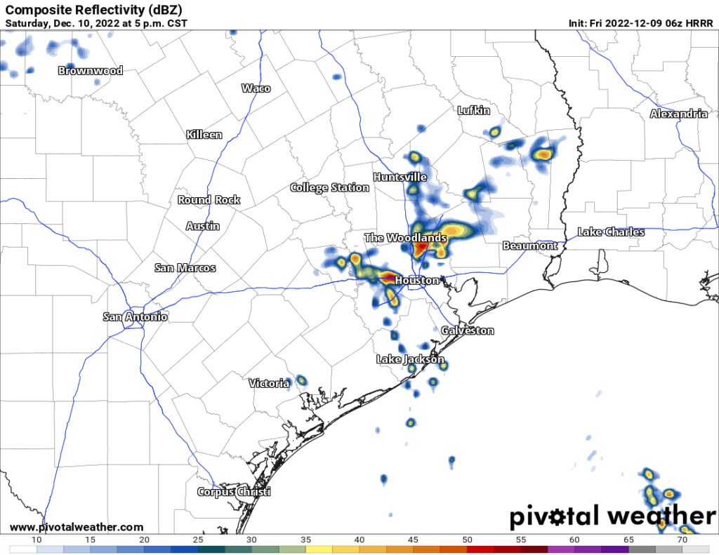
Ignore specifics, but tomorrow evening’s radar could look something like this: A few showers or downpours around, with locally heavy rain, while most people see nothing at all. (Pivotal Weather)
Again, not everyone will see rain, but some will see a fair bit of it Saturday evening through Sunday morning. Some isolated stronger thunderstorms are also possible. We’ll do lows in the 60s again Saturday night into Sunday morning, followed up by highs in the 70s on Sunday. It’s possible that on Sunday folks northwest of Houston see temperatures drop into the 60s for a time as the cold front will make one failed attempt at pushing through. For Houston and points south and east, the front making it through on Sunday is unlikely at this time.
Monday & Tuesday
We will start next week on a mostly calm note, with clouds, sun, fog, and an isolated shower for Monday. We may actually turn a bit warmer, more humid, and noticeably breezy on Monday as well, as a strong storm system begins to organize in the lee of the Rockies. A typical warm pattern setup.
That storm really cranks on Tuesday over the Plains which should drag a cold front through Houston on Tuesday night. Tuesday will be our last real warm day, with morning lows perhaps near 70 and daytime highs again near 80 degrees. Expect at least a few showers or storms with the front on Tuesday evening, but it’s too soon to say how robust that will look just yet.
Beyond Tuesday
At this point we are not expecting any real meaningful weather heading toward late next week. In fact, it looks pretty nice for pre-Christmas weather. We should see a decent amount of sunshine, highs in the 50s to near 60 and lows in the 30s or 40s. We may get a windy day in here Thursday or Friday with a reinforcing shot of colder air.
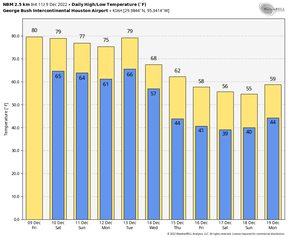
The National Weather Service’s National Blend of Models gives us decent insight into days 5 through 10, and you can see that we turn sharply cooler but not too cold for the end of next week. (WeatherBell)
Heading toward Christmas week there is a lot of uncertainty within weather modeling. We will probably get some kind of warm up for early on the week of Christmas, followed by a drop in temps later in the week. But details and exact timing and intensity are very uncertain at this time. Suffice to say, it would be wise to keep both spring and winter attire at the ready heading into the week of the 19th.
Thursday saw clouds gradually take over our skies, a sign of the expected change that we’re beginning to feel this morning. Step outside, and it feels a bit different than 24 hours ago.
Temperatures are running nearly 20 degrees warmer this morning than they were at the same time on Thursday. (Pivotal Weather)
In fact, most parts of the Houston area are almost 20 degrees warmer than they were yesterday at the same time. This heralds our movement into a milder, more humid pattern that’s likely to stay with us with minimal interruption through next weekend.
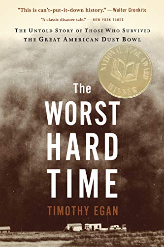
Below today’s forecast, I’ve got the latest installment of the SCW Book Club, with some comments on The Worst Hard Time, by Timothy Egan.
Today
As the warm front delivering us the change in weather pushes north today, we can expect a few things to happen. First, a few showers or pockets of light rain and drizzle will be possible amid the cloud cover today. We already have a little of that this morning. Second, areas of fog are likely to begin forming along the coast by later this afternoon and evening. Watch for dense fog tonight in Galveston and elsewhere near the bays and coast. We’ll see temperatures soar into the mid-70s or better today.
Saturday & Sunday
The forecast gets a little challenging tomorrow. A cool front is going to push into far northwest parts of the region, and that means there will be some temperatures discrepancies. Places like Huntsville or College Station through Navasota could see temps fall from near 70 into the low-60s or even 50s later on Saturday afternoon. Houston and points south and east should not see the front until later Saturday, so expect highs well into the 70s again. Temperatures will drop into the 50s in parts of the area, while coastal areas stay in the 60s Saturday night, all of this contingent on exactly where the front gets before shifting into reverse. Basically, it might not be a bad plan to have a light jacket handy in case that front is a little faster than we expect, particularly if your plans will be north of I-10 on Saturday.
As a cold front toys with areas north of I-10 on Saturday afternoon, we could see highs only get into the upper-60s in some spots, before dropping 5 to 8 degrees or so. That front should arrive in the Houston area late in the afternoon or evening, after temperatures get well into the 70s. (Pivotal Weather)
Other than clouds, fog will be an issue most of Saturday along the coast and bays and just inland from there. December is the second most likely month of the year for dense fog in the Houston area (behind only February). So, it’s that time of year. A few showers will be possible on Saturday as this front toys with us.
On Sunday, that front will start to lift back north and out of the area as a warm front, bringing back warm temperatures and humidity. We will have upper-60s or perhaps 70s again with clouds, patchy fog near the coast, and maybe a little sun. Maybe.
Monday through Wednesday
By Monday, we’ll be well back into a soupy air mass with high humidity and warm temperatures. Look for highs near 80 with clouds and a little sun, as well as a little coastal fog. Tuesday looks to be a repeat, if not a degree or two warmer. Wednesday? You guessed it; more of the same. All three days will have lows in the upper-60s to low-70s. They’ll also carry low-end shower chances, as the warm weather should keep the atmosphere fairly well “capped” I think, inhibiting showers and storms in our area.
Late next week
At this point, Thursday and Friday look fairly similar to the front part of the week with upper-70s to low-80s, clouds, and a slight shower chance. Areas of fog may be more widespread later in the week, however. As of now, let’s pencil in the next cold front for Saturday. Could be a bit faster or slower. This front may usher in a little bit of a lengthier cool spell for the week of the 12th, so for those of you who don’t like seeing 80s in December, there is hope. We’ll have more on that next week.
SCW book club
Back in spring, we started a concept called “SCW Book Club.” For those that follow me (Matt) on Twitter, you know I read a lot. Or I try to. With two toddlers that is becoming increasingly challenging! The premise of SCW book club was that anytime a weather or disaster-related item of interest entered my reading stack, I’d share some thoughts on it with all of you. In March, I reviewed Rachel Kimbro’s excellent In Too Deep about why people rebuild after repeated flooding. I said I’d get to The Worst Hard Time, by Timothy Egan, a book about the Dust Bowl. I did, but I did not get to it “later this spring.” Whatever the case, I finally finished it last weekend! And I can truly say it’s a must-read.
The Worst Hard Time is your passport to life in the Dust Bowl.
It was published in the mid-2000s and won the 2006 National Book Award for non-fiction. I approach books like this cautiously because I know they’re well-regarded for a reason. For some reason, The Johnstown Flood, by David McCullough, another of those seminal disaster narratives did not hook me as much as I had hoped. It was fascinating and enjoyable, but something about it left me wanting (I have three books by McCullough on my nightstand at present though, so I will definitely be giving him another go in ’23). The Worst Hard Time lived up to the hype.
The book does such a good job telling the story of the Dust Bowl through the lens of various residents of the High Plains. Egan’s writing captures you immediately. There were moments where it was tough to put the book down. Some books about disasters can be academic in a sense; this is not that at all.
“The land around them was tossed about and dusted over, as lifeless as the pockmarked fields of France after years of trench warfare.”
For someone like me, this book was nearly perfect. It covers the history of a major American event, a weather-influenced event. Egan went into detail about how FDR planned to help solve the issue, so it included the “politics” of the day as well. Ultimately, the story of the Dust Bowl is so terribly nuanced that even for someone that knows a good bit about what happened, it can surprise you. Between learning how many people were sold a lie, then doing what they had to do to survive and destroying the land in the process, the Dust Bowl was even less a truly “natural” disaster than I ever believed.
If you want to truly understand the Dust Bowl and what people lived through in that part of the country during that time, this is your book. If you’ve read the book, please drop some comments and share your thoughts below. I’ll be keeping tabs on them.
The next weather book I am going to get to is a book called F5: Devastation, Survival, and the Most Violent Tornado Outbreak of the 20th Century, by Mark Levine (not to be confused with political commentator Mark Levin). This book recounts the April 1974 “Super Outbreak” of tornadoes that swept across a large part of the Eastern U.S. This book is tough to find, so if you’re fortunate to grab a copy and want to read it too, feel free. I actually stumbled onto my copy at Kaboom Books in Woodland Heights, which is a delight if you ever have time.
After that, I intend to read a book entitled Air Apparent, by Mark Monmonier which traces the history of the weather map. I imagine many of our readers might enjoy this one. This is also somewhat difficult to track down, but some used copies are available over on bookshop.org. I’m looking forward to this one. Look for something on that after the holidays.
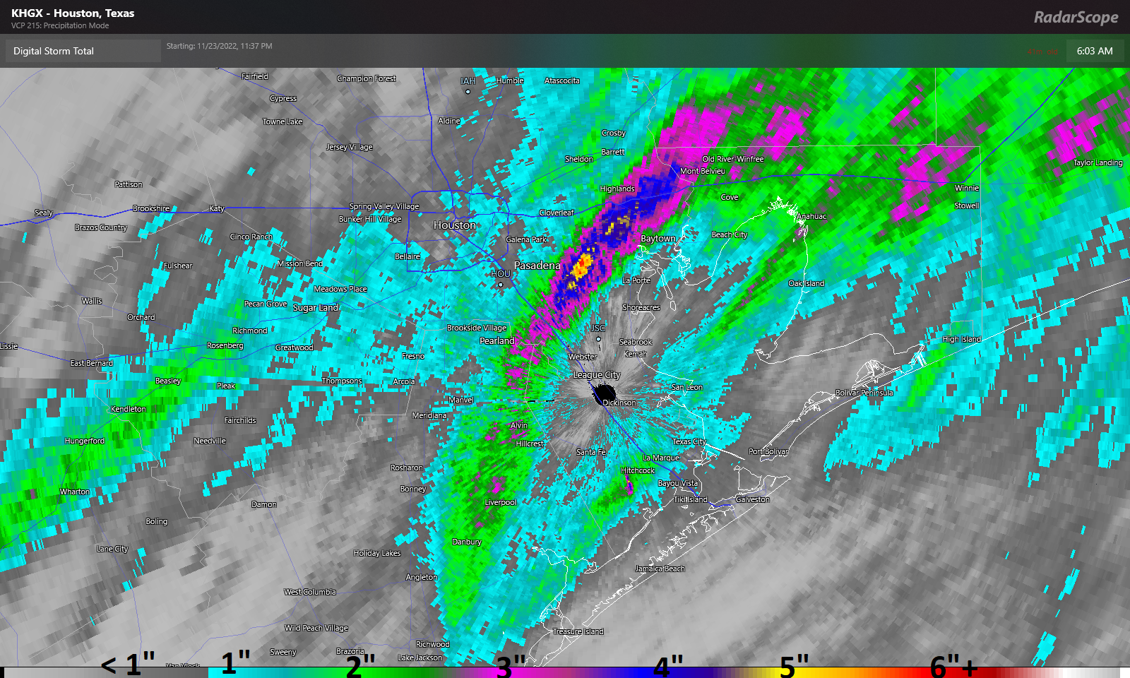
Thanksgiving’s rains were very impressive. In fact, for Hobby Airport it was a new Thanksgiving record, with 1.53″ of rain, breaking last year’s 0.59″ (set on Nov 25 last year) for wettest Thanksgiving since records began in 1930. But it was areas just east of Hobby Airport that really took home the stuffing.
Most areas around Houston saw an inch or so of rain, but a corridor from near Alvin and Friendswood through Mont Belvieu into Liberty County saw 3 to 7 inches of rain on Thanksgiving, a record for wettest Thanksgiving on record in some spots. (RadarScope)
A narrow band between about Friendswood through just west of Mont Belvieu saw anywhere from 3 to 7 inches of rainfall, with the bullseye right over Deer Park. In addition, you may have heard about the tornado warning in Brazoria County. Thus far no confirmed tornado reports have been noted, but things definitely got dicey for a few minutes yesterday afternoon. The severe threat is not zero today, but it’s relatively low and confined to areas well south of Houston.
Housekeeping/Fundraiser
I just want to open today with a little housekeeping. First, with active weather back in the area for the first time in awhile, we encourage you to download our app for your iPhone or Android device. Likewise, if you or someone you know prefers weather updates in Spanish, Maria Sotolongo does exactly that for you at our companion site Tiempo Ciudad Espacial! Maria truly does outstanding work, so please check it out and share it with any of your friends or family like weather updates written in Spanish. Maria also curates our Facebook, Instagram, and Twitter feeds for TCE, so you can follow those as well.
Related to that, our annual fundraiser is down to the wire now! There are just a few days left for you to truly help make a difference for our site. Your contributions directly help fund our work, app improvements, and tricks up our sleeve for the future. You can click here to buy items to rep the site. And if you don’t wish to purchase merchandise and just want make a contribution, click here and check the box that says “I’d like to make a donation only.” We are grateful for any and all support. Thank you!
Today
Onto the weather. A little housekeeping here too: A Flood Watch remains in effect until tomorrow morning, and Eric and I will maintain our Stage 1 Flood Alert until then as well. We continue to expect primarily street flooding to be the issue with further rains, but we also do want to monitor the area around Armand Bayou through the Clear Creek watershed given yesterday’s exceptional rains there.
The frustrating reality today is that we do not expect a washout, but there will be a chance of rain and scattered showers or downpours around virtually all day. The morning looks mostly fine, but rain showers will become more frequent this afternoon and evening. The bottom line today: Have an umbrella and a backup plan in case you’re chased indoors for a time. Temperatures look relatively stable, in the 50s and 60s, gradually warming through the day.
Later today through Saturday morning
It’s encouraging that we have a little bit of a break today because we are likely to get smacked with another round of heavy rain and storms this evening into Saturday morning. Expect periods of showers and storms to become more numerous from late afternoon and evening, culminating in what should be a pretty solid line of storms toward sunrise on Saturday. Some strong storms with gusty winds are possible in addition to heavy rainfall.
Another 1 to 3 inches of rain is expected between now and Saturday morning, with isolated higher totals that could lead to street flooding again in parts of the area. (Pivotal Weather)
We expect roughly 1 to 3 inches of additional rainfall between now and tomorrow morning, most of which will fall in roughly a 6 hour window overnight or early Saturday. Isolated higher amounts are absolutely possible. The heaviest rain seems likely to fall near where the heaviest rain fell on Thanksgiving Day, which is to say in Houston and points south and east. Street flooding will again be possible tonight and early Saturday.
Temperatures will remain stable, in the 60s.
Rest of Saturday
If you have outdoor plans Saturday, you have a mixed bag. The morning will be dicey due to lingering showers and storms, but the afternoon looks great. Rain should end from west to east between about 7 and 10 AM on Saturday. Skies should begin to clear and temperatures will bounce around a bit within the 60s with lower humidity. We should cool a bit toward the 50s by late afternoon.
Sunday and beyond
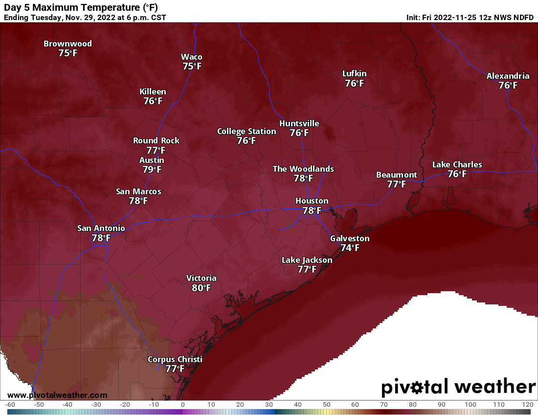
Sunday will live up to its name with sunshine. Morning lows will start in the 40s to near 50 and warm by afternoon well into the 60s. We will essentially repeat this on Monday.
If you seek a respite from the cool temperatures of late, you can look forward to Tuesday when we could hit 80 degrees in Houston. (Pivotal Weather)
For Tuesday, clouds and temperatures will increase. We have an outside shot at 80 degrees Tuesday afternoon with enough sunshine. Our last 80 degree day was on November 11th. A few showers will be possible. Humidity will also surge higher. Our next front should arrive Wednesday into Thursday knocking us back into the 40s for lows. Another fairly quick warm up seems likely for next weekend, but additional shots of cool to cold air may not be far behind. A little something for everyone.
Eric will have an update later this afternoon to set us up for tonight’s storminess.
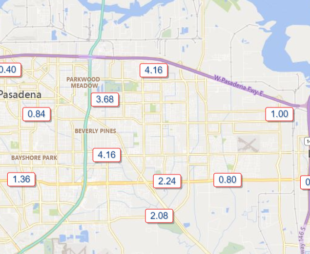
Good afternoon. Round one of rainfall this morning was mostly uneventful, with the notable exception of the Deer Park area, which received over 4 inches of rain, much of which fell in an hour or so.
Rain totals over 4″ in the Deer Park area caused some substantial street flooding in spots. More rain is to come, and Armand Bayou in particular will be running fairly high. (Harris County Flood Control)
Armand Bayou is the one bayou worth watching closest as we head into this evening. It is running near bankfull after the earlier rains, and we could see some portions of the bayou come out of banks with round 2 in a couple hours. Please stay vigilant in that area.
We remain in a Stage 1 Flood Alert, as Eric has noted, and the NWS has just issued a Flood Watch for the entire metro area through Saturday in anticipation of several more rounds of rainfall.
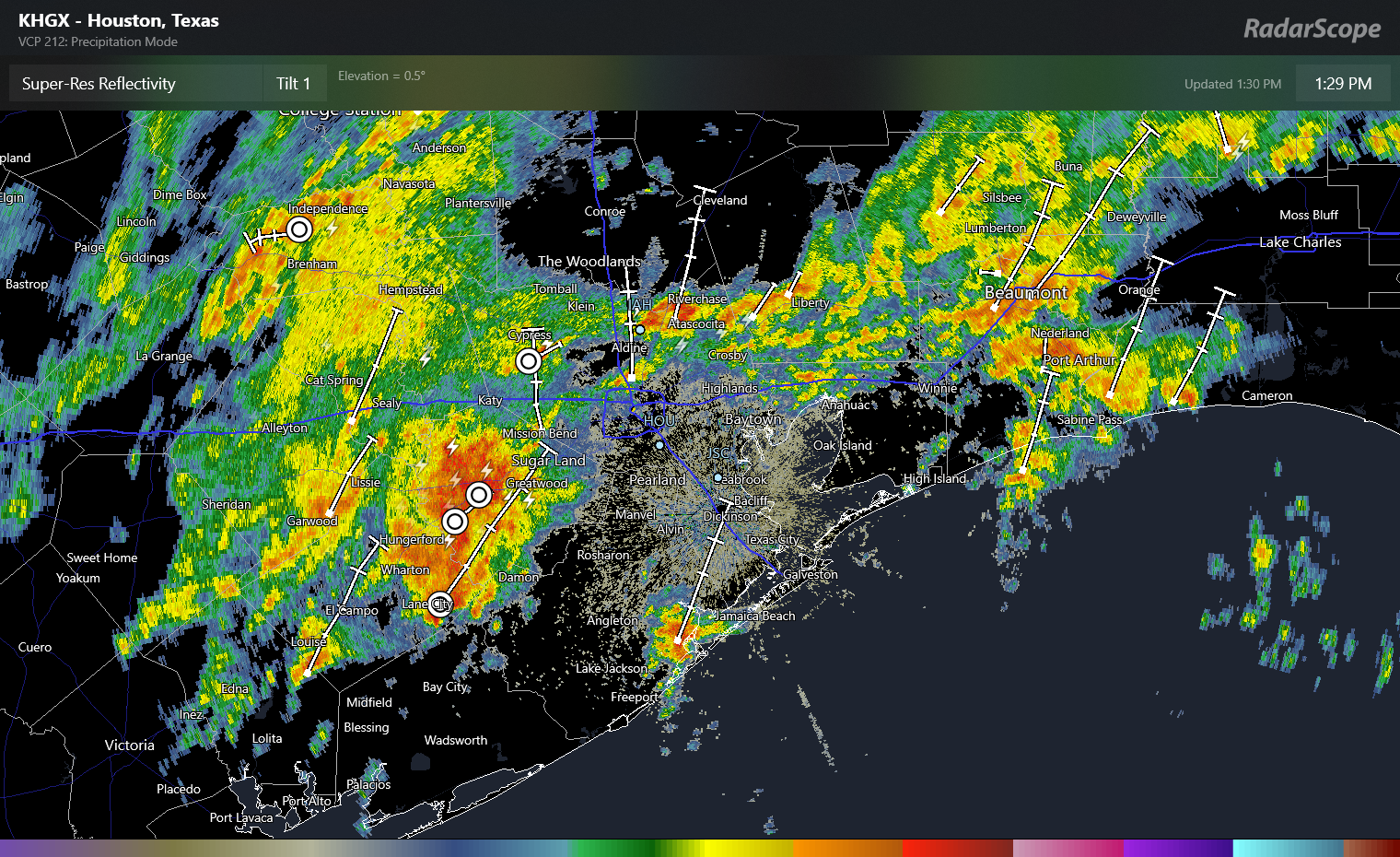
That next round is on the way as of 1:30 PM.
A cluster of very heavy rain southwest of Sugar Land will overspread most of the Houston area through mid-afternoon, with 1-3″ of additional rainfall possible where it rains hardest. (RadarScope)
This cluster of rain will produce thunder, lightning, some gusty winds, and very heavy downpours. Additional rains of 1 to 3 inches are possible as this band passes through between now and 4 or 5 PM this evening. Please use caution if you have to travel between now and then, and if you can postpone travel a couple hours to avoid the worst of the rain, that may be prudent. Street flooding is likely in spots, hence our stage 1 alert. And as noted above, we’ll be monitoring the Armand Bayou watershed in particular for any worse issues. We are hopeful that the heaviest of this rain will pass north of the harder hit areas in Deer Park this morning.
The good news is that things do settle down a bit tonight. Additional scattered showers and storms are likely once this wave passes through, and those will continue through about Midnight, but the intensity and coverage should be less than this afternoon. Overnight looks quiet with just some scattered showers possible.
Additional showers and storms are likely tomorrow and especially in the first half of Saturday. We’ll update on those once we get today’s platter digested.
A reminder: We offer our posts in Spanish at Tiempo Ciudad Espacial! If you yourself prefer reading in Spanish or have friends and family that would enjoy our site more in Spanish, please spread the word! As always, a thank you to Maria Sotolongo for always being on top of things for that site.
Fundraiser
As I sit here writing this on Thanksgiving Day, I am reminded of how thankful I am for our readers. We know you feel likewise about us, and for your trust, support, and loyalty, we are grateful! If you would like to support us in our annual fundraiser, it will continue through this weekend. You can click here to buy items. And if you don’t wish to purchase merchandise and just want make a contribution, click here and check the box that says “I’d like to make a donation only.”
Eric or myself will have another update tonight if necessary, and certainly by tomorrow morning. Thank you, and have a safe Thanksgiving.