Like some of you I am sure, being stuck in a cold house with my wife, kids, and mother-in-law in the middle of the February 2021 freeze was the tipping point for us. It was time to get a generator. Also like many of you as a result of the pandemic, we were in the middle of reassessing our living decisions and space needs around that same time. It was not until summer 2021 that we decided to move to West U and started exploring a generator for our new home.
Much like Eric did for his generator, and with his blessing, we used a portion of Reliant’s annual sponsorship to have a whole-home generator installed at the Lanza household. Reliant, of course, is the multi-year sponsor of Space City Weather. As in Eric’s case, my experience will reflect that of any consumer in my situation. We laughed, we cried, and it was not always pretty. But it got done.
Obviously, getting a generator is an investment. An average installation will likely run you between $10,000 to $15,000 depending on your home and needs, and that may have even nudged up a bit due to inflation. That said, I think we have learned from recent disasters both here in Texas and along the Gulf Coast that if you are able to purchase a whole-home generator, it will likely be a worthy investment. This is not something I really ever thought I’d do but having an infant and toddler roaming around a powerless house can change minds. My goal in this post is to describe the process of having a whole-home generator installed in a 2022 world, sharing how my experience differed from Eric’s that he wrote about last year.
Reliant works with a Houston-based company called Quality Home Products of Texas. To begin this effort, Quality sent a technician to my house back in November 2021. Joey was our tech, and he was extremely informative and knowledgeable about the process. We live in an older house (1940s) that has been modernized, so there were a few quirks about our situation in terms of wiring, logistics, etc. Those became an issue during the installation process, but broadly, Joey’s plan worked on paper. They were good at finding workable, minimally invasive solutions for a home’s unique situation.
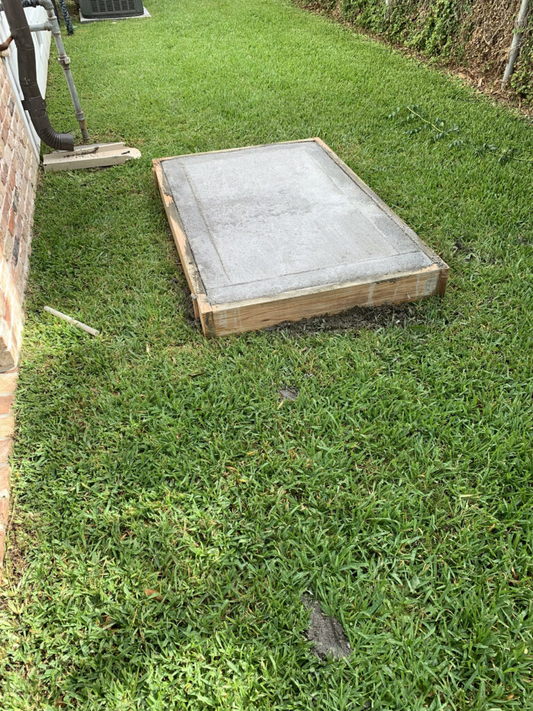
We outlined where the generator would go in our yard, placed some stakes in the ground, signed a contract and paid 25 percent of the total up front. Here is where my situation first deviated a bit from Eric’s experience. Eric’s home required a stand, but in our case a pad worked fine. To do this, workers came on two visits to construct the “outline” of the pad and then pour concrete. Both visits were quick, easy, and required little effort on our part.
The second difference from Eric’s experience was the Great Supply Chain Crisis of late 2021 and 2022. When we signed the contract in November, we were told that the process was going to be a bit delayed because of supplies. Apparently, a lot of folks want generators! The tentative timeline was that installation would probably be in February or March. Being fairly plugged into the news, I expected this, and it was just an inevitable outcome that was understandable. I appreciated Joey being honest about it up front.
Then, as it turns out, our approval process in West U hit a delay. Thus, my installation was delayed another month or two in City Hall. Finally, we got the ball rolling in April, the pad poured in May, and the installation in June. So why am I writing this in September? A number of things: My schedule and a Covid outbreak in our house, then a number of minor issues that led to five- to seven-day delays each time. We had issues getting our gas meter upgraded with some back-and-forth between Quality and CenterPoint. The regulator necessary for gas supply to the house was installed a week before CenterPoint was able to come out to upgrade the meter, leading to hot water supply issues. We also had issues with how our HVAC system connected to the generator. We had a couple parts that needed replacing. My takeaway here: Inevitably, things happen so just be prepared to deal with that in this process. There were difficult moments, but Quality worked with us fully to navigate the issues and they got the job done.
Ultimately, the generator was installed in June and we reached startup in late August.
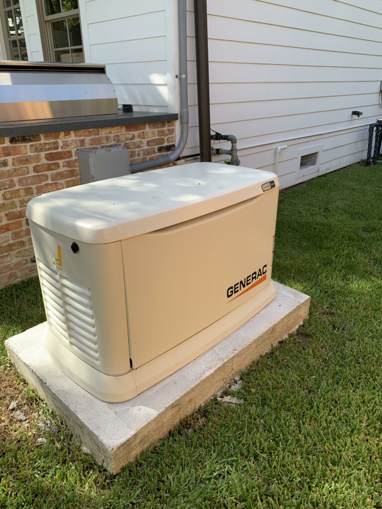
The installation process itself was about a half-day effort involving your power being cut for a couple hours in that time. Factor that into your plans if you work from home or want to avoid excessively hot or cold days. But overall, it was rather unobtrusive. The startup process was also straightforward. It does involve a brief power cut to test the generator. I got to see first-hand what would happen if we lost power, and admittedly it’s pretty cool. The power goes off, and within about 10 seconds, the generator turns on and life inside the home can resume a degree of normalcy. To ensure things stay operational, the generator is set to test itself once a week, and if anything is flagged, they’ll come out to see what’s up.
All in all, the installation process itself is not that bad. But it was a long road, and it certainly was not without a couple points of legitimate frustration. Despite a couple trip-ups, Quality does good work overall, and they have fairly comprehensive maintenance and monitoring services as well. All my interactions with their staff were positive. And to their credit, they apologized and explained the issues whenever things hit a snag.
If you decide to get a generator, plan ahead and prepare to be patient. Another piece of advice? Pay attention when they explain certain elements of the process. There may come a point where you have to explain to someone why something was done a certain way (like me trying to resolve issues between a plumber and CenterPoint). That can be taxing, but it will save you frustration. You don’t need to be an electrician or plumber to understand the whole process but ask questions and give the installers your attention.
Now, say a generator is not in the cards for you. There are alternatives to keep the critical functions of your home up and running in the event of power loss. Reliant is knowledgeable about these solutions as well and will work with you to find the right product for your lifestyle.
- Goal Zero, Reliant’s sister company, provides numerous affordable and flexible power solutions, including portable power stations that can be charged through solar panels, power banks for smaller devices, lanterns and more – all perfect for when storms roll through or getting outdoors.
- These devices can power everything from fridges and internet modems to phones, laptops and even critical medical devices. They can also integrate directly with your home’s circuits for a seamless experience.
- In the event of a major storm or grid-related problems, portable backup power solutions will give you some peace-of-mind that you’ll have power to keep important devices charged and stay connected to family and friends.
- • To learn more about backup power options, visit reliant.com/backuppower. (Reliant customers receive a 15 percent discount on Goal Zero products!)
Overall, I am grateful and relieved that this process is finally over. But as I said, while frustrating, the peace of mind we have now is tough to replicate. So was it worth it? I believe so. I also have confidence I can assist Eric in the event of a power-breaking storm! And that’s good for everyone.