Apologies for the late (or early) post, but given the situation across the area tonight, I felt we needed to update.
We’ve got two main issues of concern: Tornadoes and flooding.
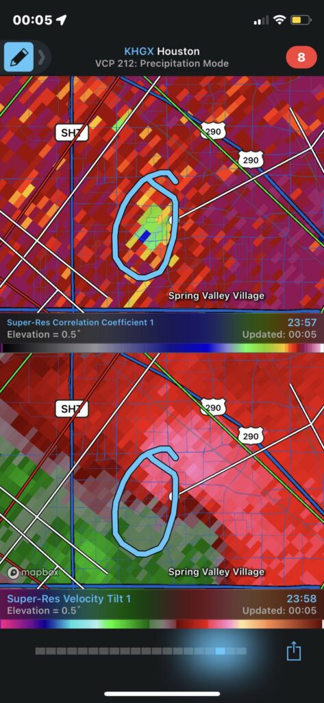
The tornado threat has flared up and down since this afternoon. None have looked especially menacing, but at a couple points we did observe tornadic debris signatures; once this afternoon just northeast of IAH Airport, the other with the late evening storms near the Beltway and I-10 west of Houston.
The tornado threat has lulled now, but just be aware that another storm or two could produce isolated, brief tornadoes. I believe that threat has peaked, but still have a way to get warnings if possible overnight.
As far as flooding goes, there is serious street flooding west of Houston, particularly from around Westpark & Highway 6 through I-10 and the Beltway northeast to near Greenspoint. Rainfall was at one point coming down at over 4 inches in an hour between Briarforest and Spring Branch. Please stay off the roads west of Houston, as that will take time to drain.
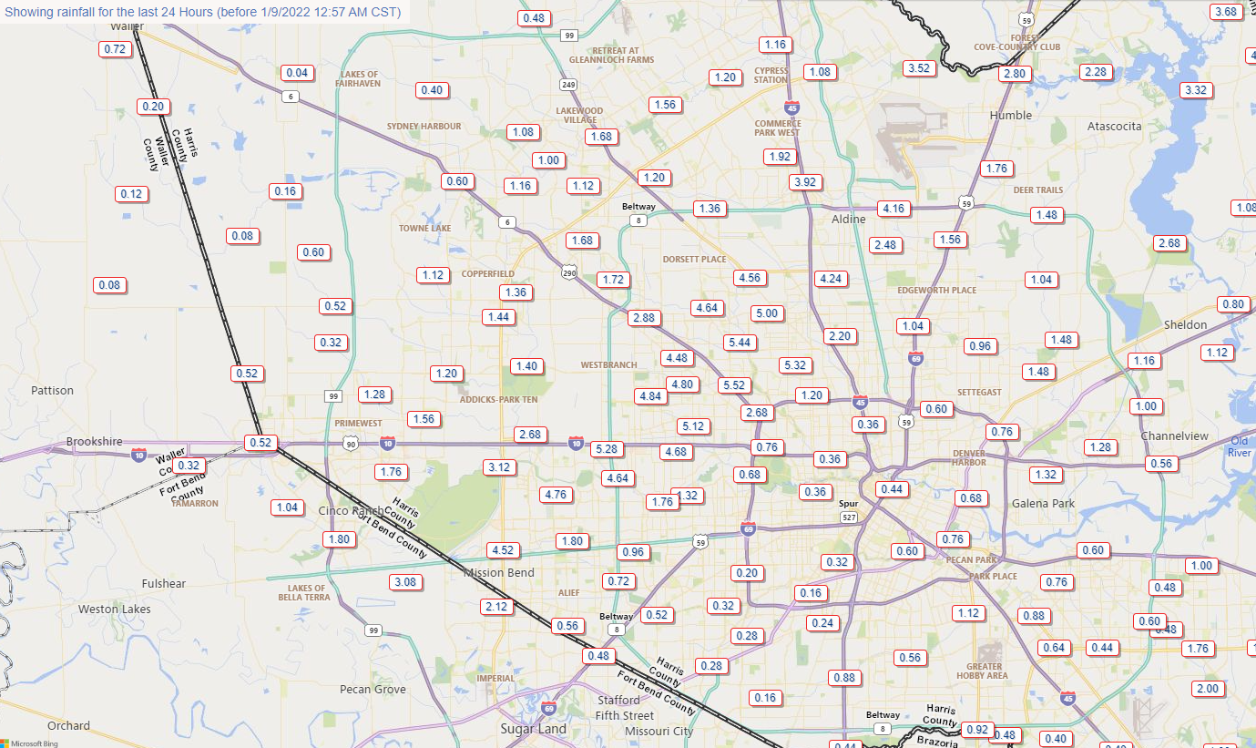
The Spring Branch area may also see creeks and drainage out of banks for a time before it subsides.
From here, we should see support for storms begin to fade. The rain will become more sporadic and intermittent, easier for drainage to keep up with. Through about 3 AM, however is when things will be the most dicey. Look for deteriorating road conditions up north between Aldine and IAH into Kingwood as well, but the hope would be that rain rates would be less than what we observed in Spring Branch.
Most of this will be done by morning, and while there is a continued chance of showers or storms tomorrow, they should not be this significant or severe. We’ll update you later tomorrow morning. Hope you’re able to get some sleep tonight.
What about the forecast of 1-2″? My cheap rain gauge accumulated 3.35″ tonight.
To be fair, we did say on Friday that some places would see “as much as 2 to 3 inches of rain or even a bit more,” and we highlighted that atmospheric moisture would be at record levels. Certainly not perfect, but not as if we downplayed this that much.
I agree…
Rain Happens.
I’m in Spring Branch. Rain gauge broke. I’ve never heard rain come down like that, not even during Harvey.
Got a scary tornado warning while on 290 on my way home… Streets flooded in neighborhood… had to walk it the last bit. Gnarly late night drive! Thanks for the update.
Thanks, Matt!
How much rain for Aldine from now to daylight do you think
As of 1:30 AM, perhaps another inch or so in a worst case situation. But it will come more infrequently.
When the eventual 4.64″ was (obviously) ramping up, I went straight to your @ to see what was up. Then the Tornado Warning hit moments later.
Grabbed the cats and threw us all in the bathroom for the next hour..
Currently getting hard rain ..again at 1:30a .
Thank you for all you do.
Now can you please make it STOP.
Matt and Eric are among the multitude people who talk about the weather without actually doing anything about it.
Hard to understand how 1 to 4 ” could get our home so close to floodi ng
It’s all about intensity. The bulk of the 4″ fell in an hour. It’s tough for any drainage system to overcome that amount of water that quickly. If that’s spread out over 2-3 hours, it’s no biggie at all.
Live on SH 321 here in tarkington prairie. No normal rain anymore its nothing or flooding
Now thatI think about it–channel 11 said 1-2″. Apologies.
Thank you! Headed for IAH at four this morning. Hope all is well by then. I appreciate these late night messages a great deal!
I was flying into IAH last night, after circling south of Houston for a while they finally diverted us to AUS at 1:30am. 😖
The storm last night was pretty intense. Thunder so loud, the rumbling shook my house like i have never felt in my life, like it was an earthquake. I live in Sw Houston, Bissonet and Gessner area. It went on for over an hour starting around 9 pm, scary.
Thunder from west woke me up in downtown area.
Most any rain event can turn into tornado or flood in Houston area = comes with the territory.
Thank you for this early update.
Space City Weather – Two guys who never sleep!
I’ve been through 4 hurricanes here in Houston and last night was the most scared I’ve been. I’m in SW Houston and it felt like the lightening was so close it was hitting the house and sky was flashing every few seconds. Prayers to those dealing with flooding this morning.
Man, that thunder was nuts! I’ve never heard it go straight without stopping like it did.
The drive home on the Westpark tollway was terrifying last night…I couldn’t see the road and at one point lightening hit a pole and sparks flew onto the road….Then on Mason, I couldn’t see again and kept running into flooded streets….I WAS NOT expecting that!
The constant, nonstop lightning lasting for hours was quite a show! It was wild! Better than the 4th of July!
Our dog didn’t like the thunder any more than we did. I think we were close to the epicenter of the heavy rainfall at around BW 8 and Memorial and it came down in buckets. Relentlessly for quite a while there. Definite training effect visible on radar. Fortunate to come out of it with nothing worse than interrupted sleep. Practically impossible to run on the Terry Hershey trail at BW8 this morning. Layers of mud.