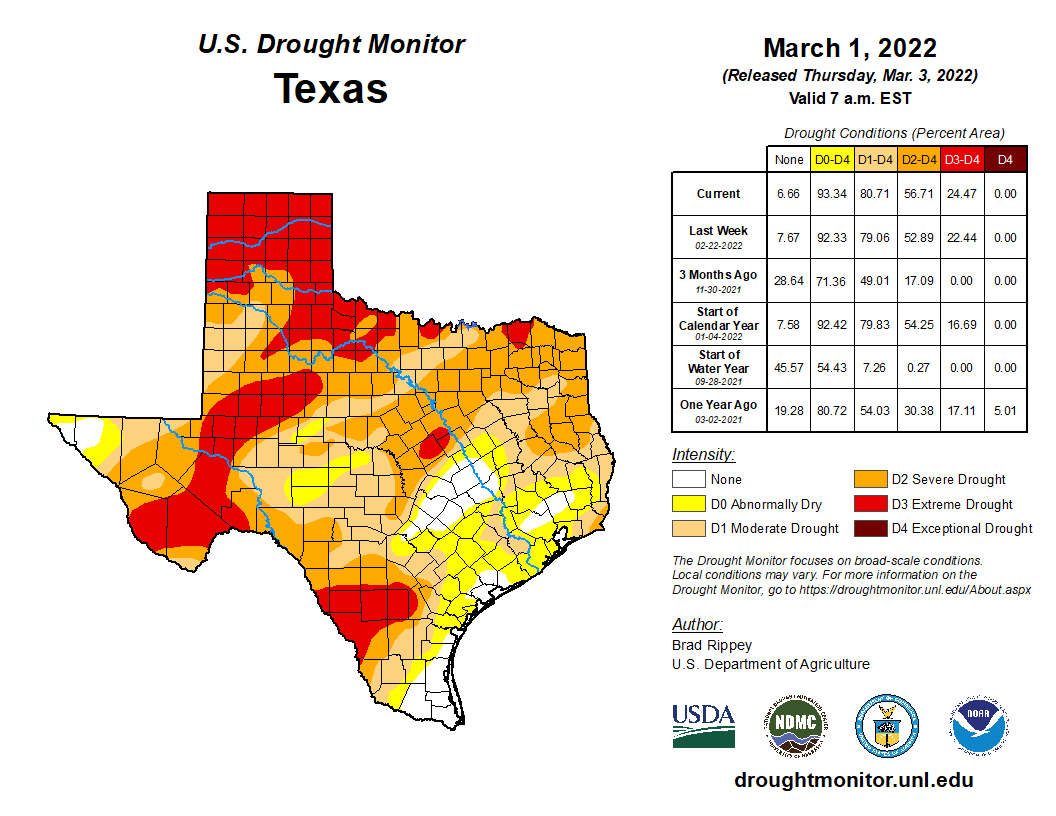
I’m going to open today’s post with a few comments about drought that’s been developing or festering across Texas. The updated Drought Monitor data came out yesterday, showing almost 57 percent of Texas in severe drought or worse.
The coverage of drought is expanding in Texas, with over half the state deemed to be in “severe” drought or worse. (US Drought Monitor)
Three months ago, less than 20 percent of Texas was in drought that excessive. We did see some improvement in early February across the state, but things have turned back worse again. Locally, things are not too bad just yet, with mostly the outskirts of Greater Houston even classified in drought at all. But rainfall is expected to average at or below normal the next 2 weeks, so this story will be one to watch in the weeks ahead. We are still technically in a La Niña (cool tropical Pacific Ocean), which tends to favor drier weather in Texas. As that has been in place over the last year or two, we’ve managed to get bailed out before things got too severe. We will see if we can pull that off again this spring.
Friday
As temperatures warm up and humidity gradually flows back into the Houston area, we continue to see some patchy fog in the area.
The rest of the morning will see gradual clearing, though Galveston and the Bay Area could see fog emerge at any point today. Otherwise, expect partly sunny skies and temperatures making a run toward the upper-70s. A few locations could even eclipse 80 degrees. There will be a noticeable southeast breeze through the day.
It’s Ricky Martin’s turn at the Houston Livestock Show & Rodeo tonight, and if you’re going, you’ll be livin’ la vida buena. Look for temperatures around 70 degrees initially, only dropping into the mid-60s after the show. No weather woes are expected, though there will be that fairly steady southeast breeze.
Weekend
This weekend will see fairly similar weather on both days: Fog, clouds, some sun, a gusty southeasterly breeze, warm temperatures, and higher humidity. Fog will be a little tougher to pinpoint due to the winds, but at times, we’ll likely see some fog along the coast and near the bays, especially in the morning. By afternoon, virtually everyone should just see clouds and sun. Look for highs in the 80s.
Saturday’s high temperatures will be quite warm, with 80s almost everywhere away from the coast. (Pivotal Weather)
Morning lows will generally be in the 60s. Any rain chances this weekend are likely to be limited to a few showers or some sprinkles, nothing that should interfere with any plans you may have.
Monday
Our next cold front will likely cross the region on Monday morning or afternoon. I would expect at least a broken line of showers and thunderstorms as it pushes through, which should give many of us some rain. Behind the front, temperatures should drop from the 70s into the 60s or 50s. We may warm up with some clearing in the afternoon, as well as drier air. But then look for 40s by Tuesday morning.
The 40s should return by Tuesday morning (Pivotal Weather)
Rest of next week
The forecast gets a little trickier after Monday with a couple quick moving systems and cold fronts in the offing. This should allow us to have a generally cooler week but perhaps an unsettled one as well. We’ll fine tune the details on that for you on Monday.
After Hurricane Nicholas passed through our area last September, I put out a post on Twitter asking followers to reply with what weather apps they have on their phones. I received hundreds of responses, and downloaded many of your suggestions to get a wide range of apps on my phone. Now, after months of procrastination and testing, I am finally prepared to answer a question we are often asked: “What weather apps do you recommend?”
I want to preface this post with a couple quick notes:
First, these are my own opinions. I’ve tried to be as objective as possible. I’m a meteorologist, so my experience will likely be different than most of you. I’ve tried to account for what I assume people would like to see in an app. But again, these are Matt’s own opinions. And this is not an exhaustive list. We left some apps out to save space. Many readers will notice the absence of Dark Sky. As I note near the bottom, because that is alleged to be discontinued this year, I have intentionally left it off. At some point, when Apple and Dark Sky complete whatever it is they’re working through, we’ll add an addendum to this.
Secondly, I’m an iPhone user. I tested these apps on an iPhone. Unfortunately I don’t have an Android capable device handy, so I cannot really speak for Android users. Some of these apps will be available and offer similar experiences on an Android phone. Others will not. I invite our readers and Android users to please comment with whatever advice or comments they have on Android weather apps.
Third, Space City Weather is pleased to offer our own app! While I most certainly think ours is the best, I know a lot of you like to shop around, and this post may also find its way to places besides Houston.
Finally, if you’re finding this post two or three years after it was published, just keep in mind that the only constant is change, and what I am writing here today represents the state of these apps in February 2022.
This will be a lengthy post. I’ll try to hit on the highlights off the top, and then I want to go app by app and provide some brief comments and screenshots.
Best App (Objective): Tie – FOX Weather & Weather Underground Best App (Subjective): Tie – Carrot & Windy Best Free Radar: Storm Radar or Storm Shield Best Lightning Alerts: WeatherBug Best Context Notifications: AccuWeather, The Weather Channel, Yahoo! Weather Best at alerting you when the rain will start or stop: Absolutely none of them.
What time will the rain hit my house?
Many of you are using weather apps to determine or get alerted to when rain will begin or end at your location, an admirable goal. Unfortunately, I tried every app that had rainfall alerts, and suffice to say, not one of the ones I used consistently did well. At all. So I cannot recommend an app that does best with rainfall alerts.
Matt’s Advice: They all performed equally poorly. There may be apps that provide this as a premium feature that do better, but I did not spend money to compare. Bottom line, if you want an app to consistently and accurately tell you when rain will begin, you will probably need to keep waiting.
What time will lightning strike nearby?
The apps did better with lightning alerts, where available. The ones that didn’t have that as a premium feature did well in alerting me to nearby lightning in cases when I didn’t hear any thunder. The WeatherBug app did best with this I thought. But honorable mention is warranted for Today Weather, MyRadar, Shadow Weather, and Storm Radar.
Watches & warnings
This gets trickier. Some apps notify you on all warned storms in your county. For instance, I got alerts for warnings for storms in other parts of Harris County from Storm Radar. Apps like AccuWeather seemed to do a better job with less over-warning. WeatherBug has a unique feature in that it warns on “dangerous thunderstorms” in addition to NWS severe warned storms. That is likely algorithmically driven, and it may result in a bit of over-warning, but it’s a feature you may not mind. Other apps allow you to toggle on or off what types of warnings you wish to receive. That can get a little clunky, as the National Weather Service has a big menu of alert products, so apps like Storm Shield may overdo that a bit, but at least you control the alerts you’ll receive. Those of you that are privacy hawks will probably cringe at the idea of these apps tracking your location or even warning for a location. Alas, for good quality warnings where you are, it’s a sacrifice you may need to make.
Matt’s advice: The ability of your phone to warn you to Flash Flood or Tornado Warnings based on your geolocation is probably good enough. If you want more watches or warnings, most apps will provide that functionality for you just fine. You may get “over-warned” at times, however, but I felt AccuWeather did a better job than most at keeping unnecessary notifications off my phone.
Forecast insights
Some apps get creative in terms of push notifications. AccuWeather did well here, providing some contextualized alerts about significant weather or an upcoming change. The Weather Channel app also did this well. But the best in my opinion was actually Yahoo! Weather. It notified on significant temperature deviations while I was using it, for instance telling me on a Sunday that it was going to be 16 degrees cooler on Monday. FOX Weather’s app also did this fairly well. Carrot provides the most personality in terms of forecast context, but I’m not certain that it’s necessarily helpful so much as it is entertaining.
Now we’ll walk through each app I used, and I’ll briefly share some comments and provide a rating (0-5, with 5 being best) based on an average score of how the app looks and feels, forecast info and insights (not accuracy), alert capabilities, radar functionality, nuance, and miscellaneous “other features” (which account for whatever else it provides). I used the free version of the apps, but many have premium options that can remove ads or unlock additional features. The apps are listed from top rated to lowest rated in my opinion.
Weather Underground (Wunderground)
Positives: The “Wundermap,” decent forecast data, acceptable radar. Negatives: A bit ad-heavy (though you can pay to remove), not what it used to be
Say what you will about what has happened with this company, it was the “OG” of clean, functional weather info for years. Recently it has lost a lot of luster among some in the weather community as it’s been handed around and lost a lot of the things that drove many engaged users to it in the first place. But it’s stood the test of time. It still presents a good forecast. The “Wundermap” is unbeatable, the density of weather stations in their network is top notch, and it comes with an acceptable radar as well. It is a bit ad-heavy, which is annoying, but there is a premium option.
The Wundermap remains tough to beat in Weather Underground’s app. (Weather Underground)
Overall: 4.3/5. A classic that still has a place in 2022.
FOX Weather
Positives: Good radar, decent push alert quality, embedded streaming Negatives: Ads, a number of things to sift through that you may not care about
FOX is the newest entrant in the TV weather wars, putting together a heck of a team, including Houston’s own Britta Merwin and Stephen Morgan. I wasn’t entirely sure what to expect from their app, but quite frankly I think it’s one of the better ones. Much like The Weather Channel (TWC) and Accu, you will get the usual dose of other “stuff” you may not care about, but FOX’s app strikes me as a bit cleaner than the others. From a radar standpoint, it’s as good as any.
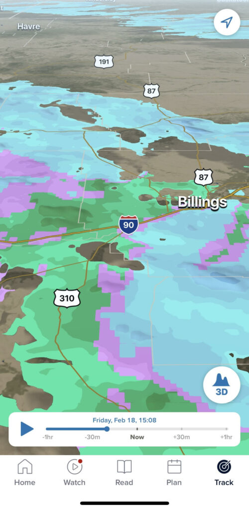
“3D” radar view of precipitation in the northern Rockies. I was a fan of the FOX Weather app, and it had a decent radar interface to boot. (FOX Weather)
You can also stream their weather channel in the app. Whether that’s a good business model or not, I’ll leave up to others, but from a user convenience standpoint, it’s nice. And from what I have seen to date, their on-air coverage compares favorably to other weather networks.
Overall: 4.3/5. An app that stands up well to the other big names and also allows you to stream live coverage.
Windy
Positives: Best interface of any app, any ads are unobtrusive, lots of cool imagery. Negatives: Better options for radar, no options for warning notifications that I could find
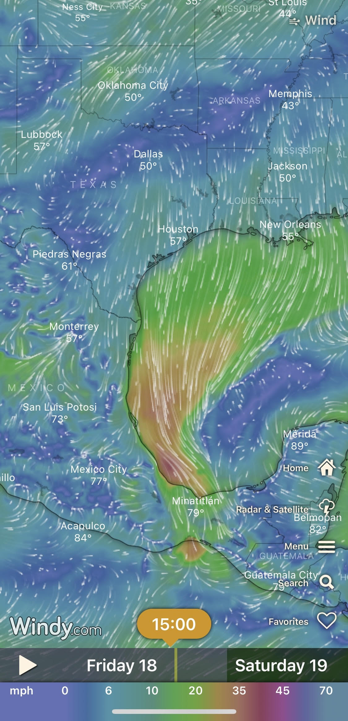
Visually, no other app compares to Windy in my opinion. I don’t like using the word “beautiful” to describe a phone app, but it’s aesthetically pleasing to say the least. Windy displays wind, as you might imagine. It provides a good sense of what’s happening as soon as you open. But that’s at a high level. Drilling down locally, it does an acceptable job. Its biggest weakness in my opinion is the radar, which just looks poorly done. I really like the satellite feature on Windy, and that’s one reason I will likely be keeping it on my phone.
The Windy app is one of the few weather apps I would absolutely recommend, for pros and novices alike. (Windy)
Windy is not terribly intrusive; it has no ads that I found, and it gives you a lot of flexibility about what forecast conditions you want to receive alerts for (provided you create an account). But there was no option to receive NWS warnings that I could find, which is a bit of a drawback preventing this from being a “one stop shop” app. Windy has a premium version, but I’m not sure you need it unless you’re hardcore into getting data at high resolution and quickly.
Overall: 4.25/5. Radar’s a bit mediocre in my opinion, no NWS alerts, but otherwise about as good as you could ask for, with tons of ways to display data in a non-obtrusive way.
Carrot
Positives: Personality, nice interface. Negatives: A lot of features that are free on other apps are premium here.
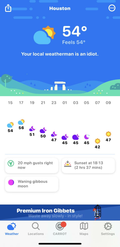
Alright, if you’re looking for something fun, Carrot may be the choice (WTForecast also garnered some mentions by people for this idea). You can customize the personality and political leanings of the app, which is kind of humorous.
Carrot offers a forecast and an insult. (Carrot)
And I mean, it runs the gamut from communist to apolitical altogether. The forecast functionality is not any better or worse than other apps, though I personally think it’s a bit better visually than some other apps. From a disappointment standpoint, the map functionality and notifications are premium only, so no free radar or alerts here. Maybe it’s worth it if you want to have some fun though.
Overall: Incomplete. This app may be good, but if you want a complete app, prepare to pay up. Sometimes these apps are more entertaining than “value add,” so test it out and see what you like about it and if it works for you.
AccuWeather
Positives: Good radar and mapping interface, notification quality was better than on most other apps. Negatives: Ad-heavy (though you can pay to remove), a lot of other stuff you may not care about
A Goliath in the field of weather, but another app that’s very acceptable. I mentioned above that I liked not receiving warnings that were not for my specific backyard. That’s a big plus of this app. The app alerted with occasional contextualized information that was helpful.
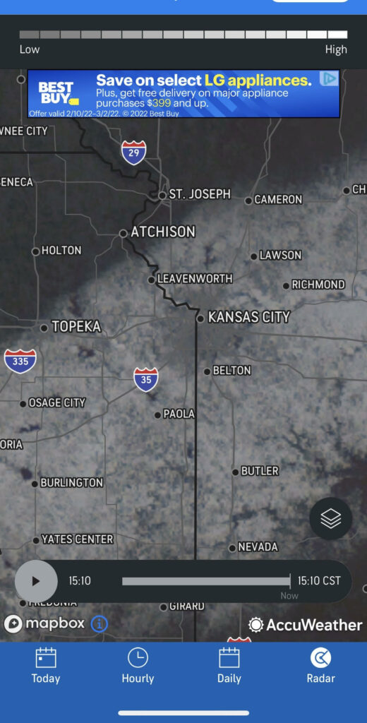
Snow cover in the Kansas City area. Ads frustrate some, but the interface is simple, generally clean, and I appreciate that AccuWeather’s app doesn’t over-warn with push alerts. (AccuWeather)
The user interface feels a bit cleaner than The Weather Channel, despite the fact that it also includes ads. The radar is also good.
Overall: 4.1/5. Another app that’s pretty much what you’d expect, but I feel that it’s slightly better than TWC in enough areas (alerting in particular) to get a slightly higher rating.
The Weather Channel
Positives: Good forecast quality, good quality radar & mapping. Negatives: Ad-heavy & somewhat intrusive (though you can pay to remove), a lot of other stuff you may not care about.
The great Goliath of weather! While it’s trendy to hate on TWC, their app is popular for a reason. Yes, you will deal with ads. Yes, you will deal with headlines and winter storm names. But you’ll also get an excellent radar, some very good model-derived forecast data, and at least a little context around the forecast.
Ads feature prominently at times on TWC’s app, but you also get decent forecast data, a good radar, and a lot of other weather info too. (The Weather Channel)
Since TWC also produces the Storm app discussed below, I might say that app is better visually, whereas TWC is better for a forecast.
Overall: 4.0/5. It is pretty much what you expect, and I wouldn’t shame anyone for including this on their device.
Storm Shield
Positives: Excellent radar and mapping, limited or no ads. Negatives: None really, but the forecast functionality may be a bit basic relative to other apps (not necessarily a negative though)
One of a couple apps I had not heard of prior to this exercise, I was curious to see what Storm Shield offered. Right off, I’ll say the radar stands out. It’s good quality, clear, and works well. The forecast functionality is pretty basic and no frills. I saw no ads, a big plus, of course.
Snow in Buffalo? How often does that happen!? Storm Shield was a clean app with a decent radar, among some other things. (Storm Shield)
There are add-ons you can purchase to get some more features. But for a generic, straightforward weather app, this works.
Overall: 4.0/5. Excellent radar, very simple, no ads, additional features if you pay.
Yahoo! Weather
Positives: Nice, clean forecast interface, more unique notifications than some other apps. Negatives: Radar & satellite functionality is much weaker than other options, ads.
When I pictured Yahoo’s weather app, I sort of pictured an outdated email interface. No offense to Yahoo or their users, but I just feel that they’re more 2000s than 2020s. Alas, their weather app is pretty slick. Their radar functionality is not that great in my opinion for Houston. And their satellite capability is kind of poor as well. But, their forecast setup I found to be the most visually appealing behind Windy. Alerting, as I noted earlier featured some nuance, which is something I value. But in general, it really is just “ok” in my opinion.
Yahoo! Weather has a nice visual appeal in my opinion, but it fell short on other metrics like radar and satellite. (Yahoo! Weather)
Overall: 3.8/5. Visually, it’s better than most. But the radar/satellite interface is not as well done as some other apps. Alerting is decent and somewhat nuanced.
Shadow Weather
Positives: Multiple forecast sources if you want to compare, relatively clean without ads, decent premium option. Negatives: A lot of features are “premium,” poor notification quality in my opinion
This app was interesting in that it offers you multiple forecast sources. At the bottom, you can scroll over and the forecast will update to that source’s data. I’m not sure how helpful this is, but it’s a feature. Unfortunately, a lot of the functionality is premium, which you can unlock by watching an ad. That said, the forecast functionality is free and also doesn’t show ads. So if you want a free, clean forecast app, this is a viable option. The forecast data is a little busy, which may be more than you want, but they do throw a little context in, with temp changes and such. The premium radar functionality is excellent though, and you can overlay things like satellite. One drawback: I felt its alerting capability was poor. Overall, this may be a decent app for you, particularly if you want to pony up for premium, but I’m not sure I could make it my default app.
Overall: 3.8/5. Good quality radar, but most features premium; forecasts from multiple sources, but alerting was poor.
Storm Radar is produced by The Weather Channel, so don’t expect any sort of dramatic forecasting differences within the app. What sets it apart from others is that it’s a pretty good quality radar that allows for zooming and all that. And for those of you more internationally inclined, this app also has radar imagery from Canada, Australia, Japan, Korea, and Europe. You can also display wind or temperatures instead of radar. The forecast portion is somewhat unique in how it displays a temperature line chart, as well as some icons, precip totals, and wind. You won’t get a ton of nuance here, but it reminds me a little of Weather Underground, which is also owned by The Weather Company. This app had an ad at the bottom that was distracting, so that’s another reason to be a bit wary. Storm has a premium version with some other features, but as a free app, it works fine.
Overall: 3.8/5. Great radar app, potentially over-alerts, nice display of forecast data.
MyRadar
Positives: Good map functionality. Negatives: Not necessarily intuitive, ads intrusive.
I liked this app to a point. I didn’t find it to be super intuitive, and it may be a little too busy for some folks, but the map functionality was really good. I felt the ads were a bit more intrusive than other apps, which may just be a result of how the app is designed. Overall, it was acceptable. The radar functionality, while not super high quality is serviceable, particularly because you can zoom in anywhere on one map. I wouldn’t say I necessarily liked this app, but I didn’t hate it, and I wouldn’t discourage you from test-driving it if you wanted.
Overall: 3.75/5. Acceptable, decent radar, a lot of alerts, somewhat intrusive ads.
Clime (NOAA Weather Radar Live)
Positives: Ability to report an incorrect forecast, customizable alerting. Negatives: Radar is not as good quality as other apps, ads.
I’m never a fan of apps that try to leverage NOAA or NWS as if they’re doing something unique compared to those working in the federal government, so I rolled my eyes at this initially. There are better options for radar, and the default includes these annoying animated raindrops, which you can turn off thankfully. The forecast interface is acceptable. One feature I really do like on this app is the ability to report to them when their forecast is incorrect. It’s really easy to do, and I wish I found this as easy on other apps. Alert customization is a nice feature also. There is a premium version you can pay for as well, which can remove ads, but I’d test drive it and some others before deciding to go that route.
Overall: 3.6/5. Better options for radars, but some unique and customization features on here that are worthwhile.
Today Weather
Positives: Forecast data straight from NWS, decent visual display of forecast info, no ads. Negatives: Nothing that stands out, though radar felt a bit “blotchy” at times.
I had never heard of this app prior to this exercise. It doesn’t seem to have anything super special, but it’s a basic weather app. The radar component is reasonable, albeit a bit blotchy at times, but it works. The forecast data comes from the NWS, which I do like. And it does have a nice chart display showing probability of precipitation, among other variables. It’s very basic, so I’m not sure you get anything other than you would from a native phone weather app or something more mainstream. But it does not have ads, which is always a plus.
Overall: 3.6/5. Very basic, no ads, a serviceable radar, and NWS forecast data. Not great, not terrible.
WeatherBug
Positives: Great lightning detection, notifications for sub-severe but strong storms, very simple forecast accessibility Negatives: Very ad-heavy and intrusive.
I used to often hear from people that “well, my WeatherBug says this.” So I’ve always taken kind of a roll your eyes approach to this app. I feel as though this will basically do what you expect, so not a lot of surprises. The lightning feature is pretty good. The radar is acceptable. One feature I do like is the easy forecast access at the top: Now, hourly, 10-day. Simple. The ads are predictable and annoying. For $9.99/yr you can rid yourself of them, so if you really like this app, that’s a route I’d consider.
Overall: 3.4/5. Basically what you expect and probably does what you want, but nothing about it besides lightning comparatively stands out in my opinion.
For those wondering, the apps I will keep on my phone? Windy, AccuWeather, The Weather Channel, Storm Shield, Carrot, Weather Underground, and FOX Weather.
If you don’t want to download a separate app for weather and you use an iPhone, my recommendations are either creating a shortcut to weather.gov on your home screen or just using the native iPhone app, as it works fine and compares favorably to most others and may improve further with Apple’s acquisition of DarkSky (the app is being discontinued this year, which is why I did not rate it here).
Other niche apps that you suggested and I have found or heard decent things about? Note: Some of these apps will cost money to both download and subscribe to various data feeds. Others are free.
Klarify: An app that can help you manage pollen and seasonal allergies. Surfline: This will help you ride the waves, though you have to create an account. Open Snow: Top notch source to track ski conditions across the country (has both a free and subscription option). RadarScope: The ultimate radar app. RadarOmega: A viable competitor to RadarScope that has grown substantially in recent years and has a lot of additional data also. SatSquatch: An app that provides interactive satellite imagery.
Hopefully you found this post informative, if not helpful. I encourage you to share your opinions on apps in the comments, including ones I may have missed. Please try to include what operating system you’re on (Android or iPhone or something else).
I’m going to start today’s post off by answering a question we get a lot of this time of year: Is it safe to get plants back outside or plant things because the risk of freezing temperatures is now basically over? Since 1980, today (Feb 18) is the average date of the last freeze in Houston. But freezing temperatures have occurred as late as early April. Given what I am seeing out on the weather maps (some fresh Plains snowpack and bitterly cold air sitting in the northern Rockies & Dakotas next week), I would absolutely advise against moving forward into spring mode just yet. Even with the cold to our north, the risk of another freeze may not be especially high in Houston. But there’s enough risk out there in the longer range forecast models that it would be prudent to hold off at least another week or two.
Today
Temperatures are rather chilly this morning. Lows are generally in the 30s in most spots. With a lingering breeze after last night, wind chill values are in the 20s. Bundle up this morning heading out the door!
Wind chills are in the 20s to near 30 degrees over most of the area as of 6:30 this morning. (NOAA)
We’ll see sun and some passing high clouds through the day today. Expect temperatures to work their way up into the mid-50s in most spots. The breeze will continue trending mercifully lighter than it was last night.
Saturday & Sunday
No issues are expected this weekend. Look for sunshine on Saturday and increasing clouds on Sunday. For those of you with outdoor plans on Sunday, you should be fine. However, I would not be shocked to see at least a couple stray showers, mainly south of Houston on Sunday afternoon or evening. Look for highs in the 60s on Saturday and near 70 on Sunday.
Morning lows will be chilly once again tomorrow morning, but south of Houston they should be at least a few degrees milder than today.
Morning lows on Saturday will probably be a little milder than today from I-10 south and somewhat similar to today north of Houston. (Pivotal Weather)
Sunday morning should be milder everywhere, with 40s for most spots and possibly only 50s south of Houston.
Monday
Humidity is going to absolutely surge into the area on Monday off the Gulf. Look for gusty south winds that will allow temperatures to warm deep into the 70s and not drop below the mid-60s Monday night. There may be some showers or a storm on Monday, especially north of Houston.
Tuesday
We’ll warm up even more on Tuesday with an onshore breeze and high humidity. Look for fog to develop, especially close to the coast. Even with any fog, we will probably make an effort to hit or exceed 80 degrees on Tuesday.
It’s going to feel more like December on Tuesday! (Pivotal Weather)
A few showers cannot be ruled out, but any organized rain will probably stay well off to our north.
Beyond Tuesday
The forecast for Wednesday and Thursday remains a bit complicated right now. A cold front is likely to slide toward the area, but whether or not it gets offshore will dictate what temperatures do. We could see lows in the 40s if the front can get offshore. If it doesn’t, lows will be in the 60s. Highs could again push 80 degrees if the front doesn’t get offshore, or we could remain mired in the 50s all day if it does. Until we know what this front is going to do, the best we can say is be prepared for two seasons and a chance of showers late next week.
It does appear, a decisive push offshore should occur by Friday morning which should allow for showers and storms over much of the area, followed by a colder, drier weekend. More details on that Monday.
Quick note
We’re going to being offering our readers a special Presidents’ Day weekend treat this year: I’ve spent some time in recent weeks playing around with and being alerted by various weather apps on my phone. This weekend, I’ll be publishing what I learned in our guide to weather apps (besides ours). Look for that tomorrow or Sunday!
Buckle up! It’s going to be a bit of a ride from the perspective of comfort over the next 24 hours. But that will setup what should be a decent weekend.
Today
This morning has a bunch of mostly light to moderate showers showing up across the region as the first piece of today’s change works through. This is not the cold front but rather what we call a pre-frontal trough, or a dryline. It will deliver scattered showers, light rain, or drizzle, mainly north of I-10. A couple heavier showers or a storm can’t be entirely ruled out to the north of Houston, but no severe weather is expected.
The sun should come out more aggressively by late morning across the majority of the area once this pre-frontal trough nudges through.
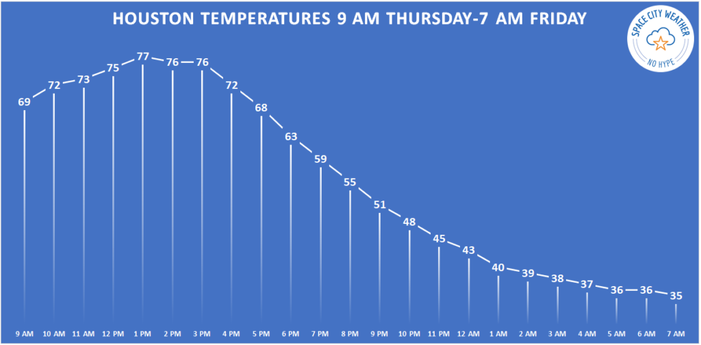
Temperatures should easily exceed 70-75 degrees in before the front sets us back about 40 degrees tonight.
With gusty northwest winds and much lower humidity this afternoon, temperatures will jump up until the actual cold front arrives. Look for that front to get to College Station before 2 PM, the northern & western suburbs of Houston by 4 PM, downtown by 5 PM, and the coast before 7 PM. Give or take an hour or two.
When the front arrives, temperatures should drop 10 to 15 degrees over an hour or two and winds will shift from the west to the north. Before that, we’ll likely see highs into the 70s in most spots, with a chance for upper-70s in the city and south and east of Houston.
Tonight
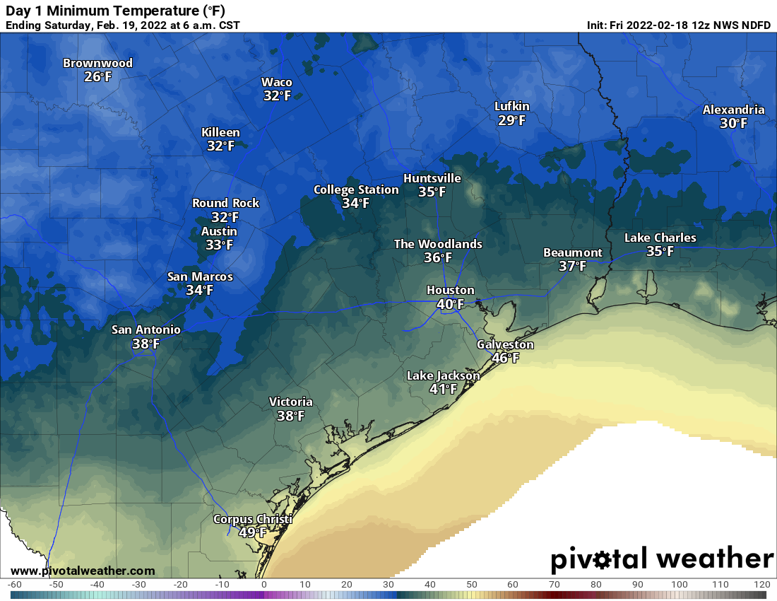
Once the front pushes offshore, we’ll see a few clouds and continued gusty north winds of 15 to 25 mph. Temperatures will continue to steadily march down, until Friday morning, when most of the region will be in the 30s.
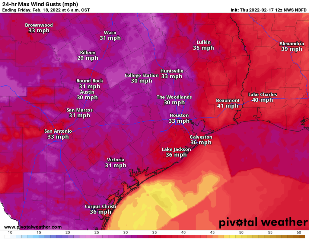
Maximum wind gusts today and tonight should peak in the 30 to 35 mph range in most spots, potentially higher along the coast or to our east. (Pivotal Weather)
Temperatures could bottom out near freezing in the typical spots well north or west of Houston (Conroe or southwest of Katy/Fulshear). Passing high clouds and the wind will likely limit just how cold most areas can get, so 35 degrees seems to be the cutoff for most places south and 30 degrees north.
Friday & Saturday
After that chilly start on Friday morning, look for high clouds through the day. This will keep temperatures in check a little further, and while mid to upper-50s is the current forecast, we may need to shave a couple degrees off that number if clouds are a little more widespread or thicker. We’ll get another dose of chilly temperatures on Friday night, but it should remain in the upper-30s to low-40s in most spots.
Saturday looks great. Expect sunshine and slightly warmer weather. We’ll march to about 60 degrees or a little warmer with a light wind. Some clouds may attempt to linger south of I-10 at times, but short of that, there should be little to trouble you on Saturday.
Sunday
Clouds will start to push back into the region as winds flip onshore Sunday. Temperatures should still be able to get well into the 60s despite the clouds. A stray shower is possible in the afternoon, especially close to the coast.
Monday and Tuesday
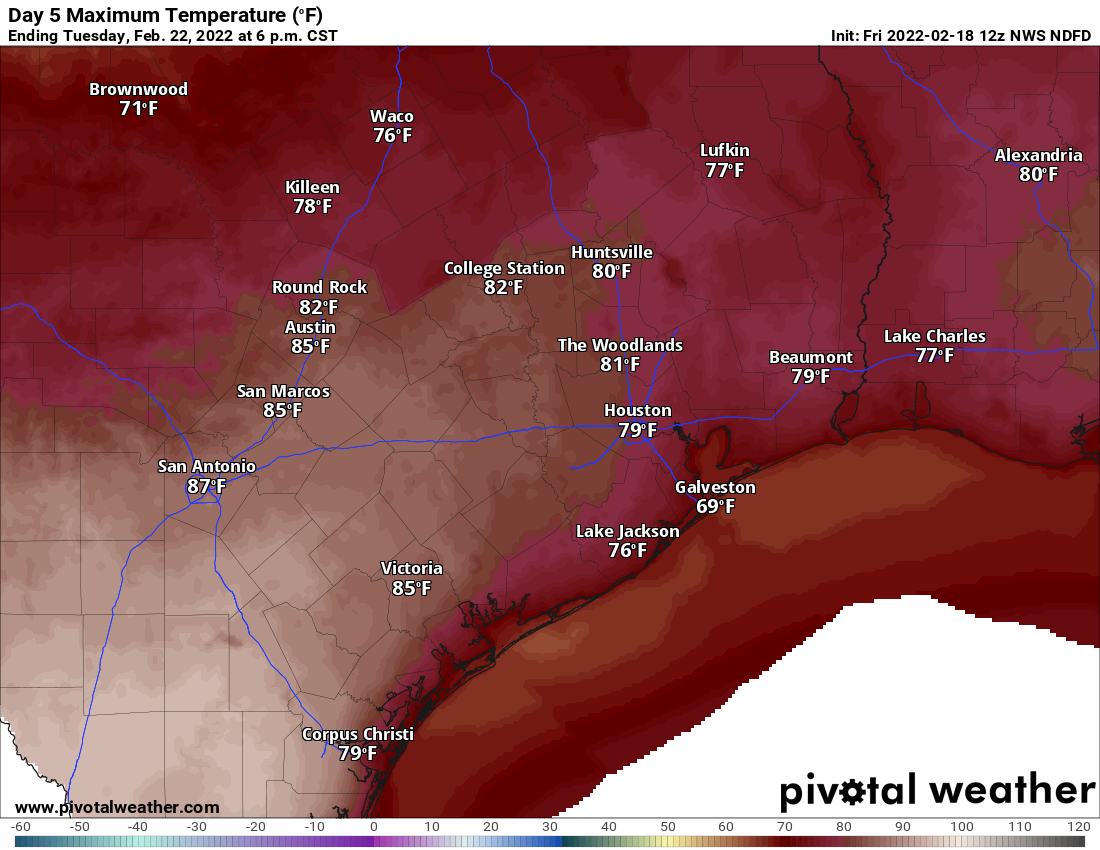
Look for warm, humid weather to settle in for both Monday and Tuesday. Shower chances will push across the area Monday and stay mostly north of the Houston area Tuesday. Temperatures should have no trouble getting well into the 70s, if not back to 80 degrees, especially by Tuesday. Morning lows will be mostly in the 60s.
Beyond Tuesday
A cold front is going to try and push through Houston on Tuesday night, but models disagree about how far it will get. This will have significant impacts on our temperature forecast (the difference between 50s and 70s), and also on our rain forecast. So the forecast on Wednesday and Thursday is kind of a coin flip right now. Look for a more decisive cold front to push through either later Thursday or Friday, and that should usher in somewhat colder air for next weekend.