Good afternoon everyone. I’ve been watching the models and observations all day, and we look to continue walking a fine line between ice, an even mix of ice, sleet, and snow, and a bigger snowstorm in the Houston area. Not a whole lot has changed from Eric’s detailed morning post, but let’s freshen up the forecast a bit based on what we’re seeing right now.
Now
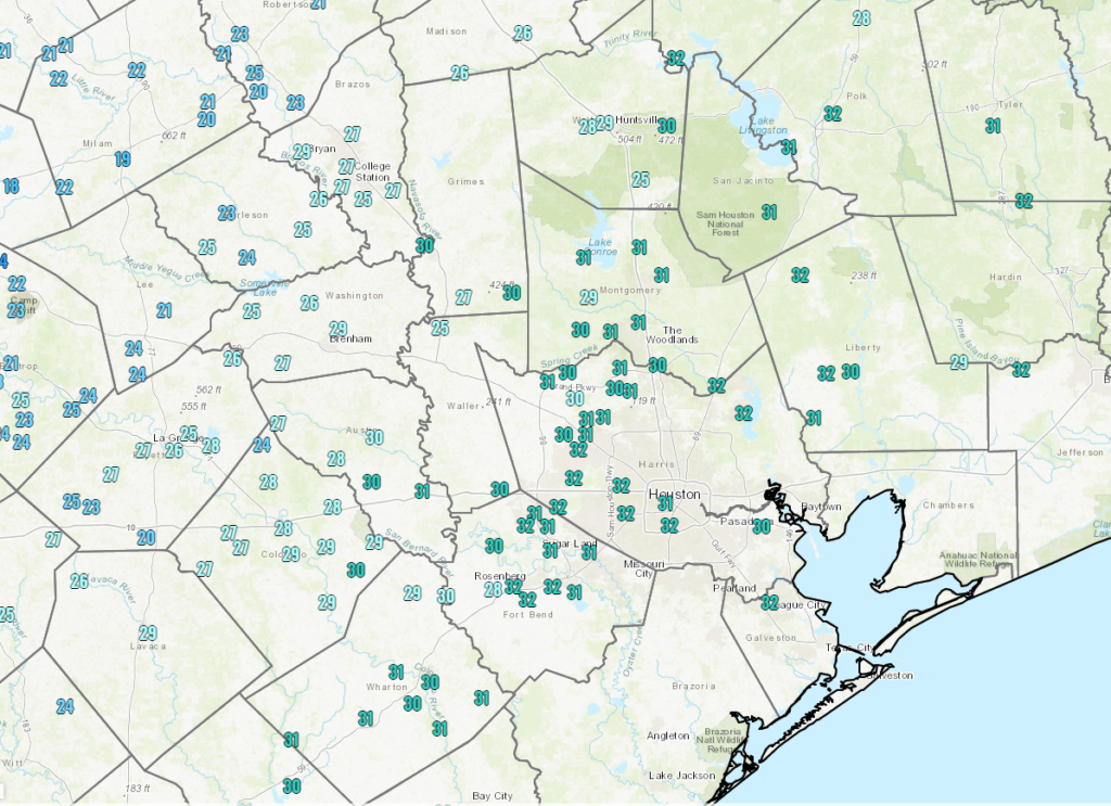
As of 4PM, here is a map of where temperatures are currently below freezing (locations above freezing not shown).
Below freezing temperatures are creeping south and east into the Houston area. Icing will commence soon on many area roadways. (NOAA)
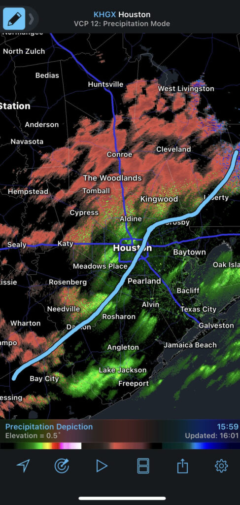
So, if we roughly overlay that freezing line on radar, you can see where the risk of ice is at the moment I am writing this.
Areas north of I-10 and west of US-59 are at risk for icing as of 4 PM Sunday. This will worsen over the next few hours. (RadarScope)
Basically anywhere along and west of US-59 and north of I-10 is at risk for icing on roadways as of now and worsening over the next 2-3 hours.
Through Midnight
Over the next few hours, watch for rain, freezing rain, and freezing drizzle to overspread most of the region. Temps will continue to glacially drop off slowly, eventually putting everywhere but probably the immediate coast below 32° by midnight. Ice accumulation should not be significant in terms of weighing down trees and power lines this evening, but you’ll begin to notice a glaze on most outdoor surfaces, and travel will become hazardous to impossible across the entire region.
Midnight to 7 AM Monday
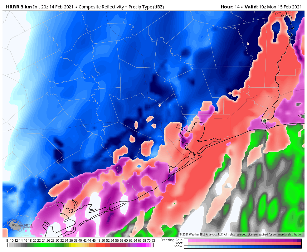
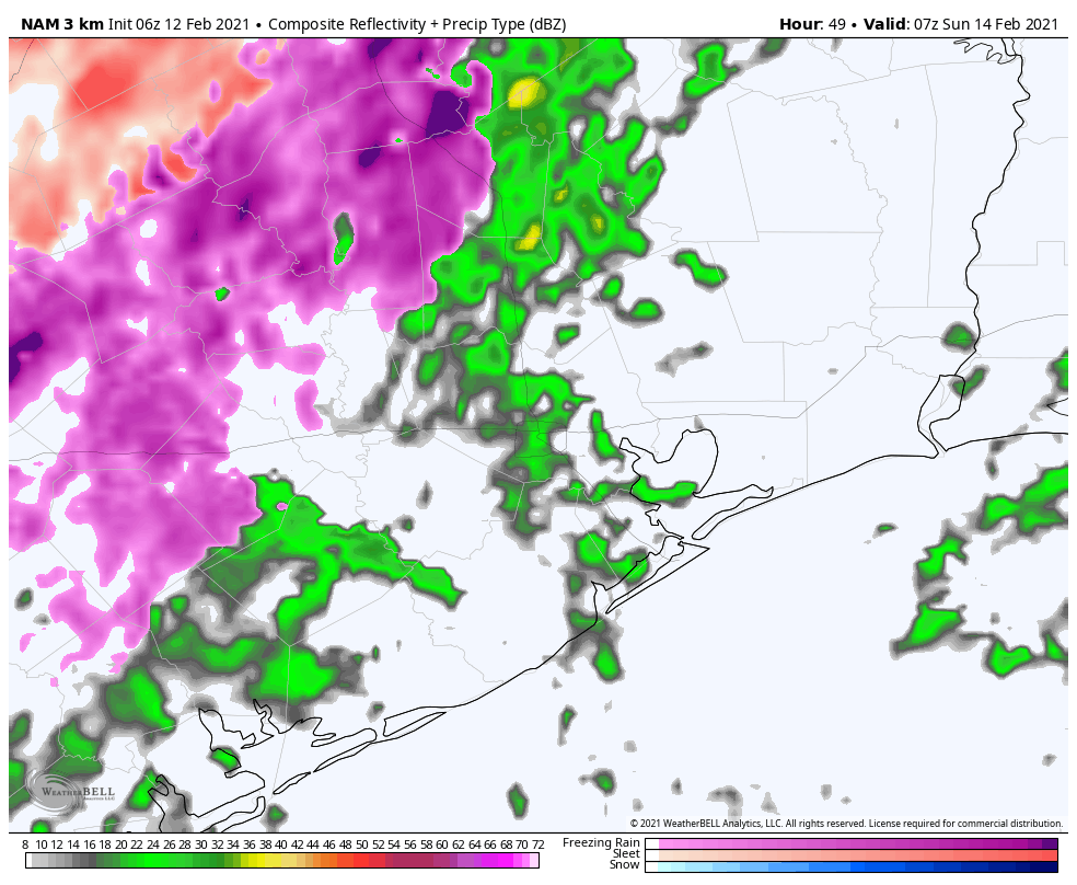
Two things will happen after midnight: Colder air will speed up its arrival in the area and the precipitation should become more organized and heavier. Our forecast confidence begins to drop off here, but theoretically, this should mean that freezing rain will transition more to sleet and eventually snow. That transition will take place from northwest to southeast and where the precipitation falls heaviest.
The HRRR model forecast of precipitation at 4 AM shows freezing rain and sleet transitioning to sleet and snow across the region. This is just one of several possibilities for how tonight may unfold. (Weather Bell)
This is when we will probably start seeing and hearing reports of heavy sleet and even heavy snow in parts of the area. I’ll be honest, as a Northeast native, what is being depicted on some of the models is the potential for bonafide, real deal heavy snow and/or sleet, particularly north and west of Houston (think far NW Harris County, Montgomery County, College Station, Huntsville), but perhaps in the city or even some places east of the city too. We’re talking potential of 1-2″ per hour snow rates if we flip over. If the warm layer a couple thousand feet up holds, then heavy sleet will the story, and we’ll see 1 to 2 inches total of “cement” on roads and surfaces.
Quick note and reminder: If we end up with sleet or sleet/snow accumulation and you have to shovel or clear surfaces, please take it slow and take it easy. There is a known link between shoveling snow/sleet and heart attack risks, to the point where hospitals up north often staff up for that very reason ahead of storms.
7 AM to Noon Monday
Precipitation should begin to wind down from west to east before Noon on Monday. Most places will end as a period of snow or flurries.
When all is said and done, expect 1-3″ of snow, more northwest, less southeast. Expect a tenth to a quarter inch of ice, more southeast, less northwest. Higher amounts are possible in either case.
Monday afternoon
Despite the precip ending, conditions won’t improve much. It’ll remain quite cold and any chance of sunshine will probably hold off til late day or Tuesday. Eric will update you on that chance in the morning. Either way, we won’t be getting above freezing on Monday, so whatever falls is going to stay in place through the day and into Monday night.
Monday night/Tuesday morning.
No big changes to the forecast for Monday night and Tuesday morning. It will be cold, likely damaging cold. Please make sure you’ve finalized all preps for pipes and plants by now, and look out for pets and neighbors.
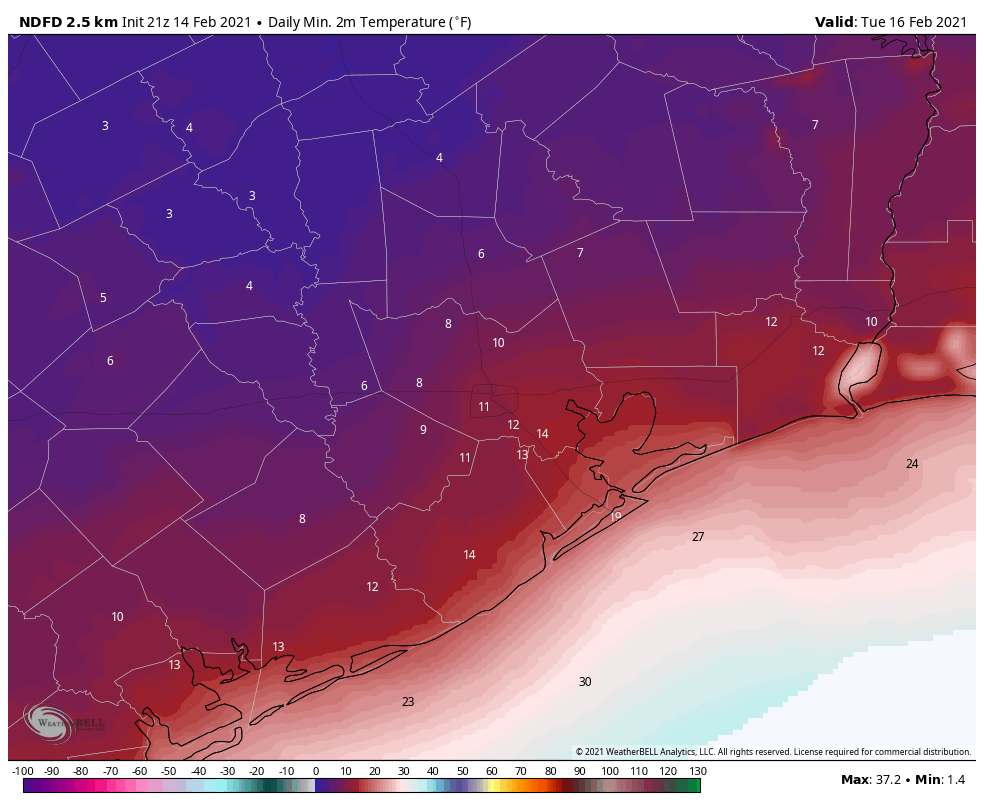
Tuesday morning low temperatures are mostly unchanged from prior forecasts and still likely to challenge records and perhaps some all-time records as well. (NOAA via Weather Bell)
There’s still a tad bit of uncertainty on exactly how cold we get, contingent on how many clouds remain, how much snow falls vs. sleet/ice, and how windy it is. But either way, a damaging, destructive, probably historic freeze is on the way Tuesday morning.
Tuesday afternoon and beyond
Look for slowly rising temperatures Tuesday, probably close to freezing from I-10 south and just shy of it north of there. We should have sunshine, and that will allow for some melting to occur, but there’s a chance most roads remain sloppy to impassable most of Tuesday too.
And then beyond Tuesday, I don’t want to speculate too much still, but it does look like Wednesday’s storm will be a mess for northern fringes of the area. The potential exists for a serious ice storm north of Houston (probably plain rain in most of the Houston metro itself). Coastal locations may even make a run at 50+ degrees on Wednesday. Between storm track issues and potential snowpack issues (keeping temperatures cold), there is a lot we don’t know about Wednesday. Look for an update by about 5:30 in the morning from Eric.
With the deep freeze on the way to Houston, Eric thought it would be a good idea to take a look at some previous significant cold in Houston, so we can place this outbreak in historical context. As Space City Weather’s unofficial history guru, I’ve taken on the challenge!
Quick forecast update
Eric’s morning post does a nice job discussing what we know and expect over the coming days. Not a whole lot has changed, though I think three things stand out.
1.) First, there is a real chance that there could be some freezing drizzle or light freezing rain overnight tonight and Sunday morning. Please check with us or other local outlets if you are planning to travel anywhere tomorrow morning.
2.) Second, the start time of Sunday evening’s precipitation has sped up a bit, and we may see rain or freezing rain or sleet begin as early as 3 or 4 PM on Sunday.
3.) It seems colder air may push in here a little faster on Sunday night and Monday morning. This is both good and bad. It’s bad in the sense that we’re likely to endure a longer stretch of temperatures in the mid-20s or colder. It’s good, however, in the sense that this might lead to more sleet (or snow) and less freezing rain. Forecasting precipitation types is extremely challenging, as Eric noted this morning, so I expect more curve balls to be thrown our way between now and tomorrow evening, but at least this afternoon, it looks like sleet may be the more common precipitation type we see tomorrow night. We’ll have more for you in the morning.
February 2021
So, to begin our trip through history, let’s set the table with the current cold outbreak.
Current coldest forecast temperature: 10° on Tuesday 2/16 Nights forecast at or below freezing: Five
The current official NWS forecast low for Houston on Tuesday morning (at IAH Airport) is 10 degrees, which would rank as a tie for Houston’s 5th coldest morning all-time (back to 1889). Since official records have been kept at Bush Airport (1969), this would rank as the second coldest, with only December 23, 1989 being colder (7 degrees).
Some may try to talk down this cold outbreak because of its less impressive duration than, say, 1989 which saw three of Houston’s 25 coldest mornings on record. However, the current Monday through Friday forecast (as of Saturday afternoon) shows an average temperature of 28.5 degrees for the 5 day period. This would rank as Houston’s 12th coldest 5 day stretch on record. If that does verify, it will be our coldest 5 day stretch of weather since 1983. So this certainly qualifies as an upper echelon, if not historic cold snap.
So let’s look back at some other memorable Houston cold snaps through the years.
January 2018
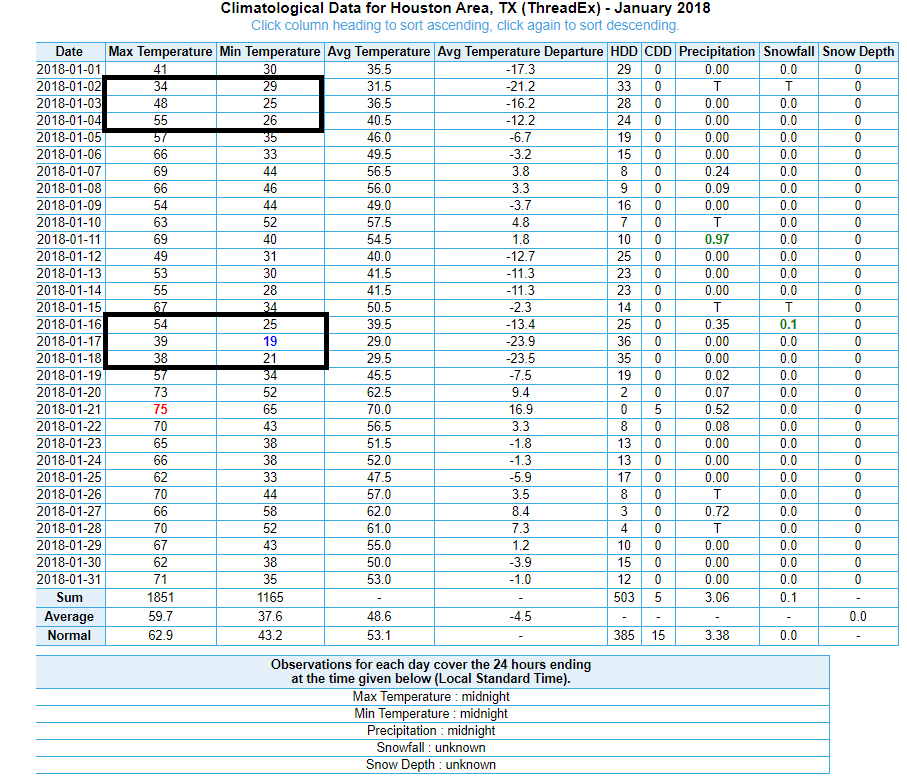
Coldest temperature: 19° on 1/17 Nights at or below freezing: 10, split up over 20 days
We’ve gotten a few comments from folks questioning how this upcoming cold could be classified as “coldest in years” when we just had cold like this in January 2018. Well, the reality is that January 2018, while impressive, was split up over 3 weeks and came with comparatively mild daytime highs.
January 2018 had its share of cold, including our coldest morning since 1996, but we weren’t able to string together a stretch quite like this week. (NOAA)
We did hit 19 degrees, which at that time was our coldest low temperature since 1996. We managed to reach the upper 30s on both days, which isn’t overly impressive. That event also came with snow, sleet, and ice. Impressive, but probably not historic.
February 2011
Coldest temperature: 21° on 2/2 Nights at or below freezing: 12 over 2 weeks
Another one we hear about is 2011. I remember February 2011 vividly because I moved to Houston for a time that month and arrived at the end of January. Quite the welcome. Houston officially bottomed out at 21 degrees on February 2nd. We registered 5 straight days with lows in the 20s from February 1-5 and 4 days from February 9-12. There was also an ice storm of sorts on the 4th. Eric wrote about it at the Houston Chronicle. I actually remember forecasting this and it being a really good lesson in the challenges of forecasting winter weather in the South.
While this was not really a record-setting event in Houston, other parts of Texas saw some impressive records. El Paso’s coldest February day on record was February 3, 2011. Dallas was plagued with cold and wintry weather as well, marring the 2011 Super Bowl.
December 1989
Coldest temperature: 7° on 12/23 Nights at or below freezing: 14 over 2-3 weeks
In pantheon of modern Houston cold snaps, December 1989 is front and center.
The front page of the Houston Chronicle from December 23, 1989, the day after Houston officially recorded 1.7″ of snow and the day that Houston recorded the coldest December day on record. (Houston Chronicle)
Six record low temperatures still stand from 1989.
December 12: 25°
December 13: 19°
December 16: 19°
December 22: 13°
December 23: 7°
December 24: 11°
December of 1989 was Houston’s coldest December on record back to the 1880s. Between crop losses and other damage, the cold of December 1989 was estimated at the time to cause $300 to $500 million in damage (up to $1 billion in 2021 dollars) in Southeast and Coastal Texas, according to NOAA’s December 1989 StormData publication. This event merits a whole post on its own, which we’ll hopefully one day get to!
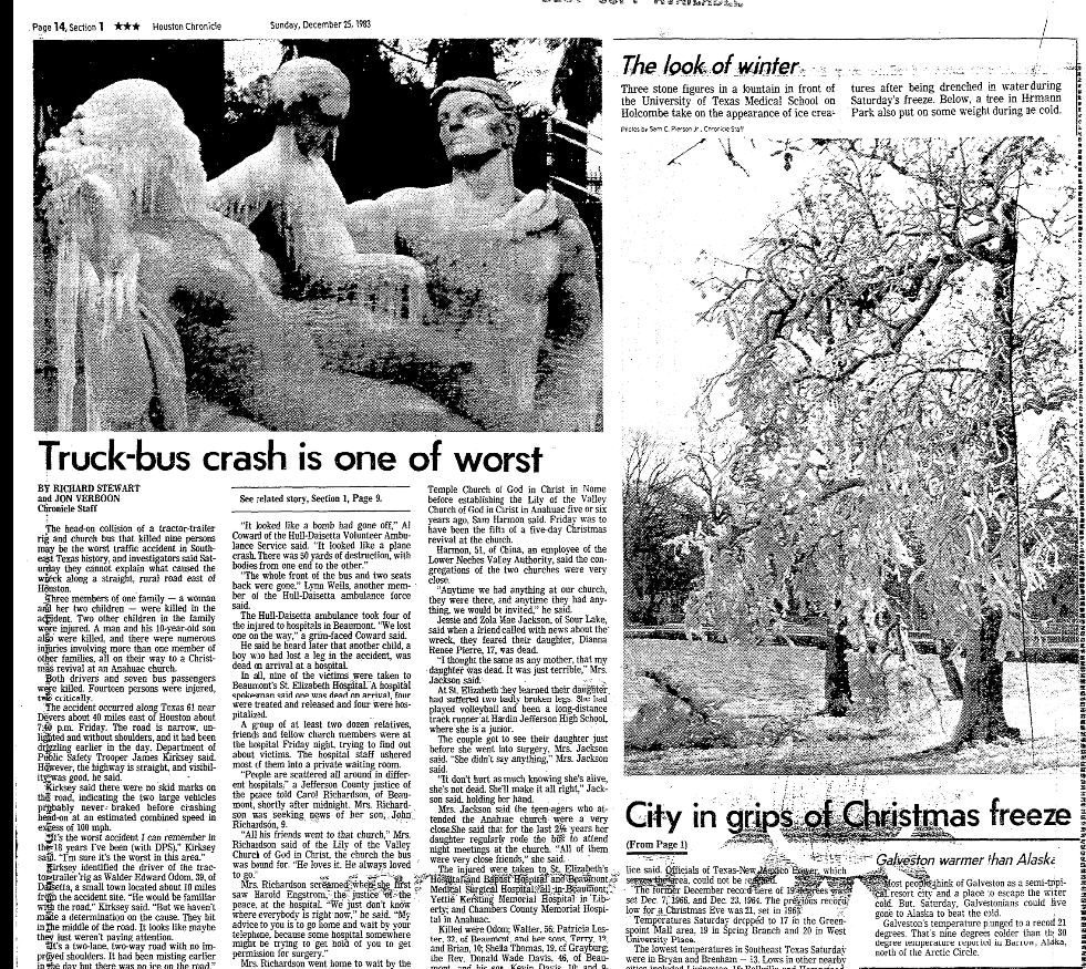
December 1983
Coldest temperature: 11° on 12/25 Nights at or below freezing: 12, including 11 in a row to close the month.
The December 1983 cold wave was another hall of fame event for Houston. We closed the month with 11 straight mornings below freezing, including four full days that failed to crack above 32 degrees.
The Christmas morning Houston Chronicle featured pictures of fountains turned into ice sculptures in Houston. (Houston Chronicle)
The 1983 cold snap caused an estimated $50 to $100 million in damage in Texas at the time (up to about $250 million today). December 1983 is Houston’s second coldest December behind 1989. December 1983 was to Dallas what December 1989 was to Houston, leading to their coldest December on record.
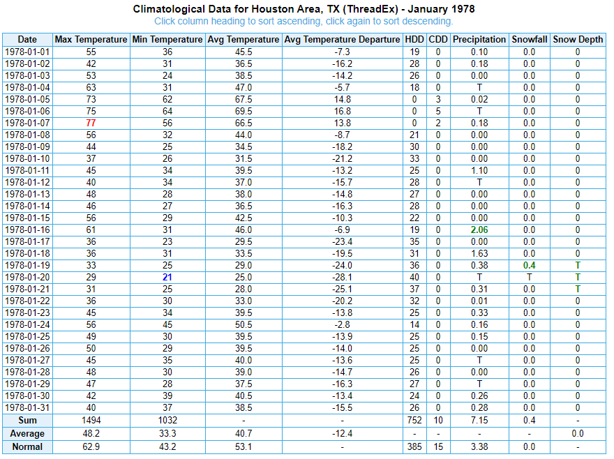
January 1978
Coldest temperature: 21° on 1/20 Nights at or below freezing: 20 (!) over the course of the month
The January 1978 cold snap doesn’t have much intensity on any single day, but it makes up for that in terms of duration, which ultimately led to 1978 being our coldest January (and coldest month) on record.
Frequent fronts ushered in cold, Arctic air through most of January 1978, which led to a low to moderate intensity, but sustained cold air outbreak over Houston. (NOAA)
The 1970s had some pretty amazing winters across the United States, and for Houston this was almost certainly the peak. Although, 1973 saw four days of snow in Houston between January and February.
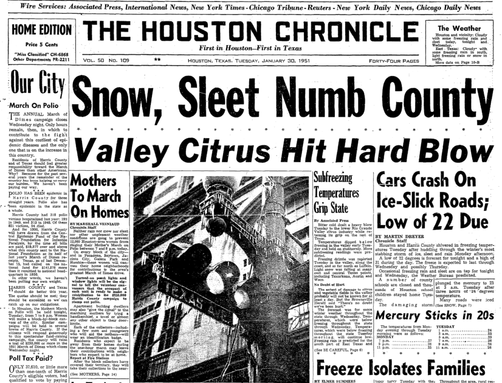
January-February 1951
Coldest temperature: 14° on 2/2 Nights at or below freezing: 6 in a row
January 1951 started off quite mild with 14 days in the 70s. The switch flipped on January 28, when temperatures dropped 40, and then January 29 when they kept dropping to 24 degrees. We then had four straight days below freezing all day long. The January 29-February 3 period remains Houston’s coldest stretch of 6 days on record, averaging 26.3 degrees.
January 30, 1951 front page of the Houston Chronicle, one of several days that saw the region dealing with disruption and damage due to ice and excessive cold. (Houston Chronicle)
In addition to the cold, what is likely the worst ice storm in city history led to serious damage and disruption. Almost an inch and a half of precipitation fell during the cold snap. Another event likely worthy of its own post.
January 1940
Coldest temperature: 10° on 1/19 Nights at or below freezing: 11 in a row
The 1940 cold snap came with snow on January 22nd, with up to 3 inches reported from Houston into southern Louisiana and more elsewhere in the states. Only twice has Houston seen 11 straight days of low temperatures at or below freezing: January 1983 and January 1940. The 1940 cold is notable for both intensity and duration.
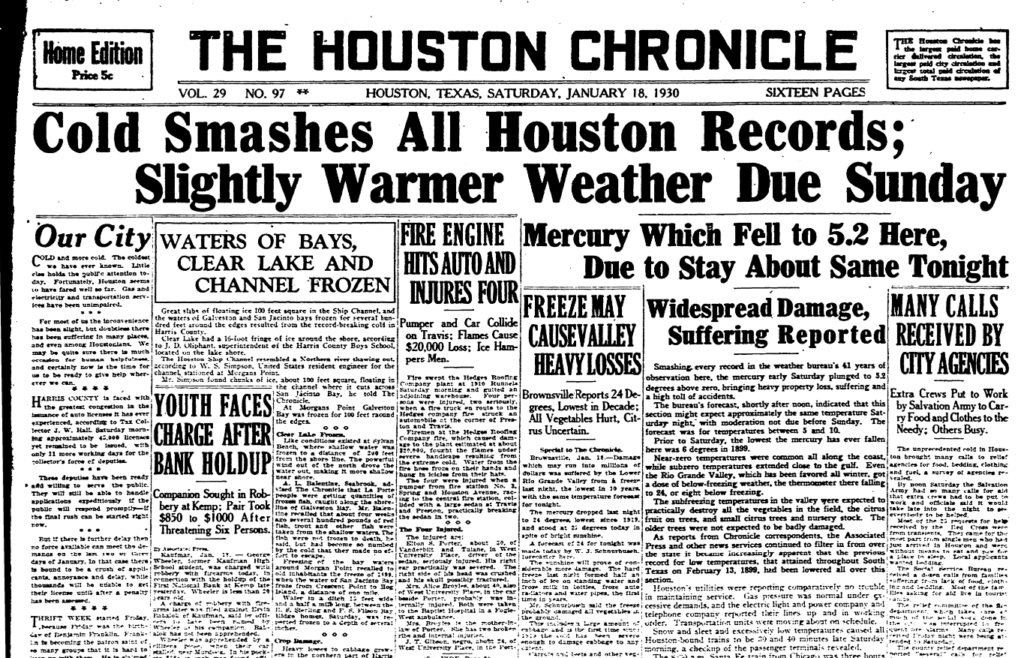
January 1930
Coldest temperature: 5° on 1/18 Nights at or below freezing: 8, coming in two 4-day waves
January 18, 1930 is Houston’s coldest morning on record, with a low of 5 degrees above zero. The cold came in two punches, this first strong one, followed by a second one a couple days later in which we bottomed out at 15 degrees on the 22nd.
The January 18, 1930 Houston Chronicle trumpeting the news of Houston’s coldest recorded day. (Houston Chronicle)
Five days after hitting 15 degrees, we were back up near 70, so further proof it won’t stay cold forever!
February 1899
Coldest temperature: 6° on 2/12 and 2/13 Nights at or below freezing: 9 in a row
The February 1899 cold snap covered most of the eastern half of the United States, and it could be deemed the granddaddy of them all in the South. Several records from that event still stand today, including the coldest on record for Amarillo (-16°), Dallas (-8°), Galveston (8°), and the Texas all-time record (Tulia was -23°, a record shared with Seminole in 1933). In addition to Texas, state records still stand or are shared today from this cold snap in Nebraska, Ohio, Louisiana, and Florida.
The February 13, 1899 edition of the Houston Post described the cold snap thusly:
“When a younger friend approaches him now and suggests to him, with a degree of profanity based on the length of time he has been exposed to the chilling, biting, nipping North wind, that ‘it’s pretty cold,’ the oldest inhabitant cannot yawn, draw closer to the welcome fire, and say, with an air of conscious superiority, ‘Yes, but away back in ’73 there was a norther that–.’ He has no recourse but to moodily assent, put a few more coals in the blazing grate and reflect on what has been, what might have been and what may be. And all this makes him sad, very, very sad.”
February 1899 is front and center in the pantheon of cold as well.
February 1895
Coldest temperature: 10° on 2/8 Nights at or below freezing: 12 over the course of 2 weeks
February 1895 was a memorable cold snap, with 4 daily records still standing today. But what set 1895 apart for Houston was our greatest snowstorm of 20 inches, which we conveniently wrote about back in 2017!
The final word
So, will 2021 join these memorable cold snaps? Probably. But ultimately, whether it really can join the ranks of a 1989 or 1983 or 1899 will depend on just how cold it gets Tuesday morning.
Bonafide winter has arrived in Texas, and we’re just getting started. This may be Texas’s most severe and damaging cold snap since the 1980s, and it’s going to come with a significant mess on Monday, so do read on.
Today
After yesterday’s fireworks via quite a few thunderstorms in the area, we expect today to be a bit quieter. There should still be some showers, and there may be some drizzle as well. But we aren’t expecting much more than a few hundredths to tenths of an inch of rain today, and some areas will stay completely dry. The best coverage of showers should be south and east of the city. With plenty of clouds, temperatures won’t go far today. Look for highs maybe getting to 40 degrees or so, low-40s if you’re lucky.
Note to those traveling north or west of Houston, as we get a lot of questions: There may be some patchy freezing drizzle well off to our north, especially this morning. So if you’re headed to Austin, Waco, or Dallas, be hyperaware of road conditions. Bookmark drivetexas.org for updates for the state and the Houston TranStar site for additional local conditions.
Saturday & Saturday night
Tomorrow will likely be a similar sort of day to today. Expect clouds, some showers, some light rain or drizzle, and cold temperatures struggling to get to 40 degrees or so. There could be a slightly more vigorous disturbance that pivots through very late in the day Saturday or Saturday night and brings more numerous showers. If that happens, there is the chance that areas north of I-10 get close to the freezing mark and freezing rain (ice) could become an issue.
Forecast radar from the NAM model for 1 AM Sunday morning, showing rain in the Houston area (green) and freezing rain or drizzle north and west of Houston (pink). Just one model’s depiction, so we’ll need to watch this period closely. (Weather Bell)
This would likely be mainly focused on the nighttime hours. The Houston area should just see a cold rain, but if you have to make your way north of Houston for any reason after 6 PM Saturday, you will want to pay particularly close attention to any forecast updates this weekend. Lows bottom out in the low- to mid-30s.
Sunday
That Saturday night disturbance should exit stage right on Sunday morning, and the majority of Sunday looks dry but cloudy. Because of the generally drier conditions, we may be able to sneak into the low or even mid-40s on Sunday afternoon.
Sunday night through Monday afternoon
So, here’s where the troubling part of our forecast begins to emerge. As we’ve been discussing for days now, a strong disturbance and storm system are going to pass through the region on Monday morning. We are growing highly confident in wintry precipitation impacting almost the entire region, including the coast on Monday now. There is a good chance that travel may become close to impossible anywhere in the Houston area beginning early Monday morning.
Here’s what we know right now:
Rain, or a wintry mix will develop on Sunday night.
It will likely quickly transition to all freezing rain and/or sleet, except maybe at the immediate coast before sunrise Monday.
Precip may be heavy at times Monday morning.
Frozen precip will likely end as some sleet or snow flurries by early Monday afternoon.
Ice and/or sleet accumulation is likely across much of the area.
Temperatures will likely remain below freezing all day Monday, dropping into the lower 20s by afternoon.
Winds will gust to 20-25 mph most of the day Monday.
Now, for what we really don’t know:
Whether sleet or freezing rain will be the dominant precipitation type (snow seems mostly unlikely except well north and west of Houston or at the very end of the event).
How much sleet and/or freezing rain falls.
If there will be snow accumulation at the end.
The exact timing of the storm. (still some 3+ hour differences among various weather models)
How many power outages will occur.
Those first two points are very important, as there is a monumental difference in impacts between an all-sleet storm, an all-ice storm, and an ice storm followed by sleet. A couple inches of sleet is a nuisance, but it’s not severely problematic. A tenth to quarter-inch of ice with gusty winds and bitter cold could be extremely problematic. And a layer of ice caked over by sleet or wet snow is even more problematic. Unfortunately, we really aren’t good enough to predict winter storm precipitation totals to that specificity this far in advance. I can tell you that having looked at model data, they are loudly implying that a large portion of the area will be at risk for icing on Monday. This event will likely be problematic.
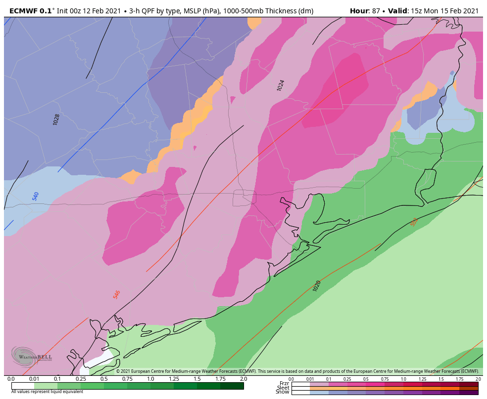
Forecast precipitation types from the ECMWF (European) model on Monday morning. Freezing rain (pink) would extend from the Houston metro to about the coast, with sleet (orange) and snow (blue) off to the northwest of Houston. This is, again, just one model’s depiction of the weather, however other models we use aren’t terribly different. (Weather Bell)
Much like flooding events, models struggle mightily when it comes to exact placement of the bullseye of a winter storm. But even putting that aside, any amount of ice on the roads here will make travel close to impossible, and that seems to be the direction we are heading for Monday.
So to summarize: A winter storm will impact the majority of the region late Sunday night through Monday afternoon with a sleet or ice storm being the most plausible outcome right now. We would strongly encourage folks to prepare to remain wherever you are from Sunday night through Tuesday morning. This forecast will change between now and then, and Eric and I plan to keep you posted all weekend long.
Monday night & Tuesday
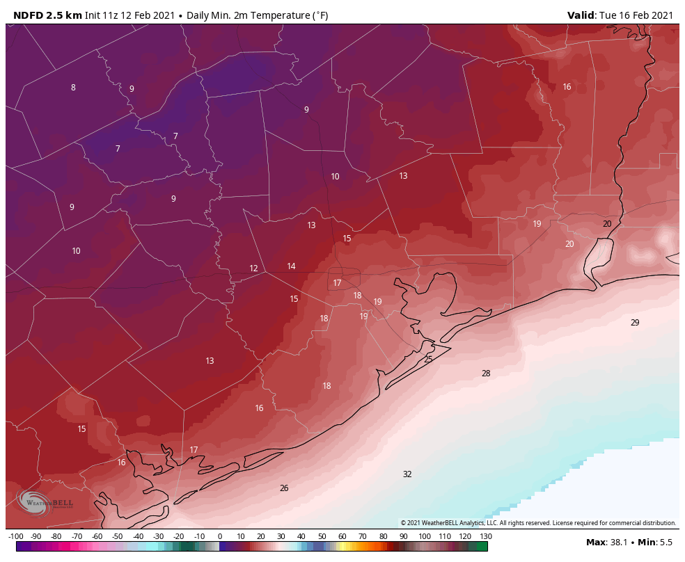
The temperatures will be the big story once our storm exits Monday afternoon. We will likely see highs on Monday near freezing very early, dropping into the low-20s by afternoon. Those temperatures will continue steadily downward Monday night. The current forecast from the National Weather Service for Tuesday morning is shown below.
Forecast low temperatures for Tuesday morning. We likely haven’t seen a map like this since December 1989. (NWS via Weather Bell)
Yeah, that’s cold. We are expecting the city of Houston to bottom out at 15 to 20 degrees. The western and northern suburbs will likely fall to 10 to 15 degrees. Bay Area and coastal locations will be around 20 degrees, give or take. If we were to somehow see accumulating snow on Monday, you could probably subtract another 1 to 3 degrees from these values at least. The last time Houston officially hit 15 degrees? December 1989.
Tuesday will see sunshine at least! We should break out above freezing by late morning. The combination of the sun and temps in the mid-30s should allow us to melt most of Monday’s ice. We hope.
It’s worth noting that this won’t be just an extreme cold event in terms of temperature. It will also be so in terms of duration. Temperatures will likely drop below freezing in Houston on Monday before sunrise and not make it above freezing til mid or late Tuesday morning. This will easily be a 24 to 36 hour stretch of subfreezing temperatures for Houston, with a longer-duration north of the city. It has been over 30 years since Houston has seen this kind of cold weather. You absolutely need to prepare your home for the impacts. Reliant has provided some very useful advice below. You can also read more cold weather prep tips here, here, or here.
Later next week
I’ll be honest with you: I don’t even want to think about later next week right now, but the reality is, more headaches are likely. Another storm system is likely to impact the region on Wednesday into Thursday. This will also potentially carry a potpourri of precipitation types. Whether we see snow, more ice, or just plain rain remains to be seen. More cold will follow, and although we are unlikely to see the teens again, there is some chance we have another hard freeze (mid-20s?) by Thursday or Friday mornings. We’ll get more into that Sunday or Monday.
Note from Our Sponsor:
As Houstonians are prepping their attire, gardens, pets and plans for the freeze, Reliant wanted to share some tips on prepping your home to stay warm during the expected winter weather.
Stay Warm Tips:
Here are a few things you can do immediately to reduce energy consumption and still stay comfortable. Best of all, they’re simple and free.
Let the sun in. Open blinds and shades during the day and remove any solar screens so the sun can warm your home.
Check your thermostat settings. For every degree above 68°, you can expect a 3-5% increase in your heating costs.
On vs. auto. Ensure the fan on your thermostat is set to “auto” not “on” to prevent it from running 24/7.
Close heat escape routes. Be mindful of how often you’re using bathroom or utility room ventilation fans and ensure the damper on your fireplace is closed when not in use, as heat can escape from your home through these outlets.
Set your ceiling fan to rotate clockwise. This helps force warm air down from the ceiling into the room to create a more comfortable environment in colder seasons.
Home Prep Tips:
A few home improvement projects can help keep your heating system from working harder than it needs to.
Consider installing a Nest programmable thermostat. This can help you reduce energy usage by up to 15% without lifting a finger.
Eliminate cold air leaks by weatherstripping exterior doors and windows. This is a relatively quick and inexpensive way to help save up to 10% on total energy costs. A few additional places to check are pull-down attic stairs, dryer vents and exterior wall outlets.
Try the paper test: Open an exterior door, insert a piece of paper and close the door. If the paper comes out easily, the gap is too large and can contribute to cold air leaks.
Get an annual heater tune-up. Make sure your furnace or heat pump is clean and in good working order, so that it can run as efficiently as it should.
Check your insulation. Ultimately, a home without proper insulation and weatherization can lose up to 40% of heated or cooled air.
Check out more on winter weather prep and common causes of high winter electricity bills here.
It was officially 80 degrees yesterday in Houston. We fell one degree shy of the record high at both Bush & Hobby on Thursday. Today will not be a repeat of that, not by a longshot.
Today
It’s starting off in the 50s and upper-40s this morning, and honestly, temperatures may not go very far from these values today.
It’s a lot cooler out there this morning than it was yesterday! (NOAA)
Today is going to be one of those chilly, raw, damp winter days here in Houston with off and on showers or light rain, a lot of clouds, and a bit of a breeze.
We could use a little rain, so hopefully we can snag a couple tenths of an inch here or there through the day. Look for showers to diminish tonight, with partial clearing and lows generally in the 40s, though a few spots up north could drop into the upper-30s.
Weekend
Tomorrow will start similarly kind of gray. We should hopefully see breaks in the clouds during the afternoon. And we’ll see complete clearing once another cold front sweeps in Saturday afternoon or evening. Ahead of that front, look for highs in the 60s tomorrow. A chilly night is on tap for Saturday night with lows dropping into the 30s and 40s. Sunday looks spectacular. Expect a lot of sunshine, high temperatures in the 60s, and light to moderate winds.
Monday through Wednesday
Onshore flow will kick back in late Sunday, so Monday morning will not start off nearly as chilly as Sunday morning. Look for morning temps in the 50s, with a few upper-40s scattered about. Clouds will be with us on Monday as well. Despite the clouds, temperatures will surge to near 70 degrees.
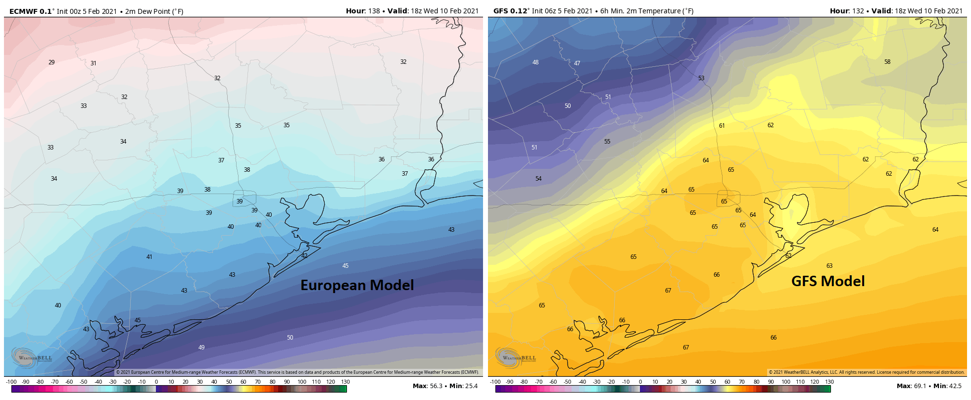
The forecast begins to fall off the rails Tuesday with some changes since yesterday. A cold front is projected to get close to Houston by Tuesday afternoon. Models differ dramatically on the timing and orientation of the front through Wednesday and even Thursday, with the GFS model stalling it in our neighborhood and the European model suggesting it stalls well offshore. A map of forecast dewpoints for Wednesday shows this well.
We have a real forecasting headache next week, and it begins on Tuesday or Wednesday, as the European model (forecast dewpoint shown on left) clears a front offshore, while the GFS (forecast dewpoint on right) hangs it back to our north. Who is right? Next question. (Weather Bell)
This obviously has implications on everything from temperatures to cloud cover to fog potential to shower chances for next Tuesday and Wednesday. If the front clears, expect highs in the 60s or 50s Tuesday and Wednesday, with lows in the 40s Wednesday. If the front does not clear, expect highs in the 70s, perhaps well into the 70s and lows in the 60s, along with fog at the coast or even into the city. Normally, I’d say the cooler outcome is probably correct, but the GFS model tends to have a bias where it’s too fast with fronts pushing offshore so seeing it be opposite of that gives me a little pause. At the same time, models tend to struggle with the type of cold air masses we are expecting in our region by midweek next week, bringing them in too slowly. So the forecaster’s conundrum is in place next week, and either outcome seems perfectly reasonable. We’ll have a good bit more clarity on Monday.
Late next week
The forecast really goes off the rails later next week. All we can tell you at this point is to expect unsettled weather and potentially the coldest weather of winter. Models have taken a bit of a dramatic step colder since yesterday for next weekend, with most reliable model guidance indicating a freeze, if not a hard freeze will be possible focused on Saturday or Sunday. Whether or not that actually happens will depend on how the potential for rain or wintry precipitation exactly plays out next Friday and Saturday. I think Eric’s 20 percent call on snow risk is still reasonable, though I think I might unfortunately call it “snow OR ice” right now. I wish we could be less vague, but this period has been in flux for several days. Either way, we believe you will want to continue to monitor the forecast for the end of next week and weekend in the coming days and be ready to implement your cold weather preparations later next week. It’s been a minute since we last saw 20s in Houston in February, last occurring back in 2014. A reminder that, although rare in recent years, it can absolutely still get quite cold this late in our winter. Much more to come on this.