Good morning. We’ll run down both storms this morning, though at a high level our concern and interest is primarily focused on Laura at this time.
Marco
Tropical Storm Marco continues to try and become a hurricane this morning in the Gulf.
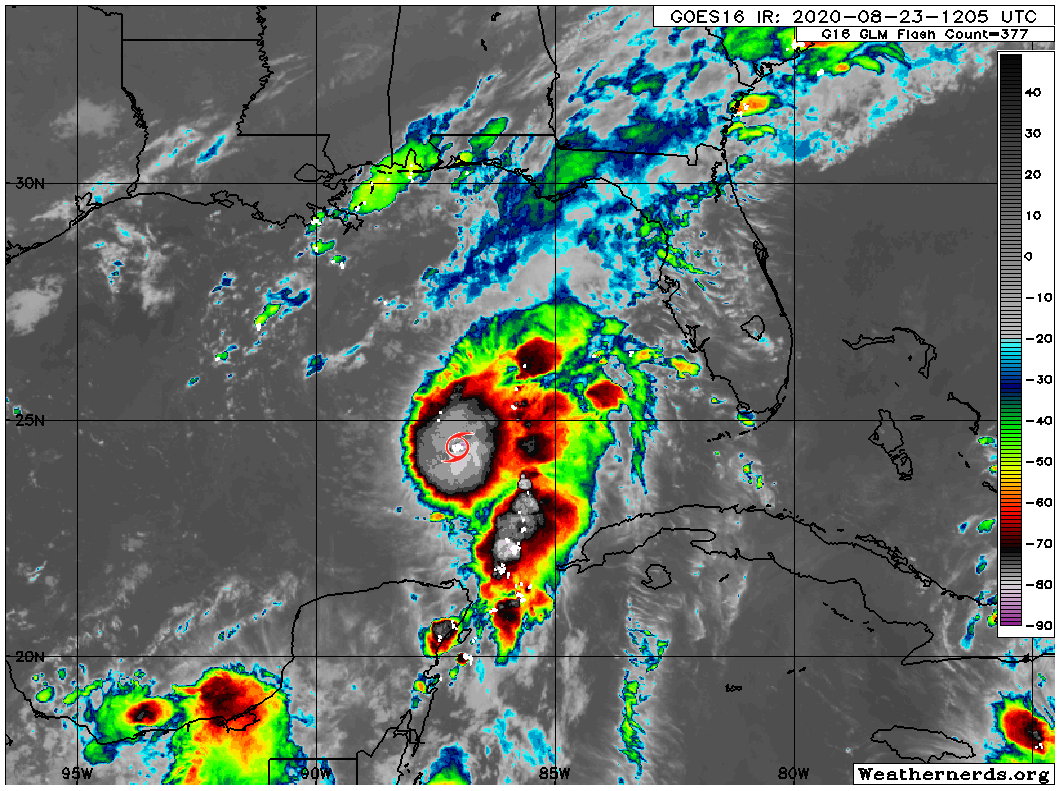
Marco is expected to continue lifting just west of due north today, and it is aiming for a landfall somewhere in eastern Louisiana before making a fairly hard left turn and basically falling apart over southern Louisiana.
We have seen a model or two bring the remnants more west along the coast, which would increase some storm chances for us and deliver some localized heavy rain on Tuesday, but right now those issues aren’t expected to be too serious.
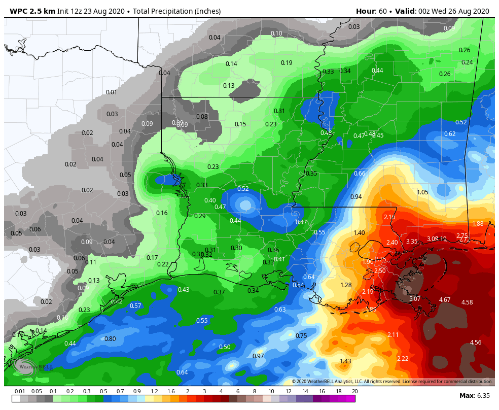
Rainfall through Tuesday evening is expected to be mostly minor, with the best chance of something heavier along the immediate coast and lesser chances inland. The heaviest rain remains directed into eastern Louisiana.
The brief summary on Marco: Perhaps a small hurricane into southeast Louisiana before it dissipates while shuffling west across southern Louisiana, keeping most heavy rainfall well off to our east.
Laura
Tropical Storm Laura looks impressive this morning, mainly because it’s coming out of the typical nighttime peak in thunderstorms, and because it is doing this while interacting with Hispaniola, which often rips these things apart. Laura is the unfortunate one that actually gets by Hispaniola without a lot of trouble because it was disorganized to begin with.
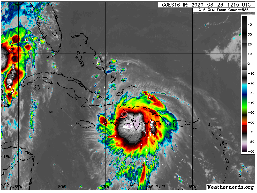
If you want to provide some criticism of Laura, it’s that the storm is somewhat lopsided. But short of that it has a healthy core of storms, some developing outflow, and it is now exiting the highest hurdle it needed to survive, Hispaniola. Cuba comes next, but the bottom line here is that Laura has the skeleton it needs to become a healthy tropical system when it eventually finds a more hospitable environment for strengthening, likely Tuesday and Wednesday over the Gulf.
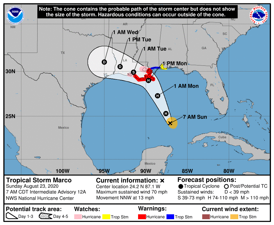
Laura’s track has shifted a little to the west since yesterday, but if you read between the lines in the National Hurricane Center’s discussion, there are likely to be more westward shifts to come.
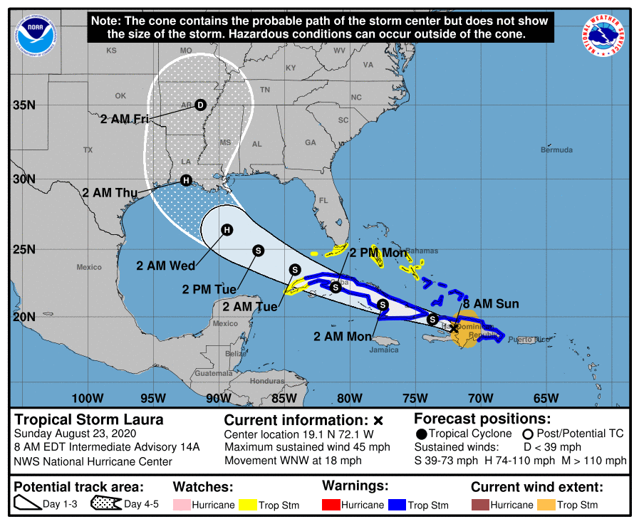
The battle lines right now are between some of the typical global models we use for day to day forecasting, which take Laura farther west, more into Texas and the tropical models we use for situations like this, which have skewed a little farther east, more into western Louisiana. Laura is going to basically work around the periphery of high pressure off to our north and east. Typically, we would expect the global models to have a better handle on the steering situation, so there is a reason to put some trust in them over the hurricane ones for track right now. Once Laura works across Cuba and emerges into the Gulf tomorrow, we will have a better idea of whether Corpus, Houston/Galveston, Port Arthur, or central/eastern Louisiana are most at risk. Right now, all we can tell you is that trends since yesterday have only served to give us more pause about how close Laura may come to southeast Texas. We continue to urge you to pay close attention to this storm and make your preparations today in case they need to be implemented quickly tomorrow and Tuesday.
How strong will Laura be when it gets where it’s going? That’s a great question, and right now, the reliable model intensity guidance ranges from a low-end category 1 storm to a high-end category 3 storm. Given the history of the Gulf, the fact that it’s going to be in a fairly favorable environment for strengthening, and frankly how it has performed so far, we would likely lean toward the higher end of things with respect to intensity right now. The NHC forecast is calling for a category 2 hurricane at max, which is right in the middle of reliable guidance at this time. Hurricane intensity remains a very, very difficult thing to predict and though we are bullish on this storm’s strength right now, there are still risks equally spread that we may be too aggressive or not aggressive enough. More clarity on this should come tomorrow.
As far as rainfall goes? That is always a concern, but Laura is expected to keep moving and no models indicate a slowing or stalling. For all intents and purposes, we are viewing this a tropical threat (storm surge, wind) first and foremost and a rainfall flooding threat secondarily. Again, please stay aware and ready to act.
Eric will have our next update posted no later than 3 PM today.

I wanted to THANK YOU Matt and Eric! I tell all my local friends about you all because of how honest and accurate you are! You remove the hype and hysterics that local media has to do for ratings and viewership. And you offer honest forecasting, even when it’s not the best news. But we can trust it because of all the other times you’ve told us not to worry. I also so greatly respect your humility and authenticity when you say that this is what you know, but the rest is still uncertain. Most would be too prideful to admit that especially when others are making (false/made up) claims. Thank you so much!!!
Greatly appreciate your matter-of-fact reporting of these storms. Lived here all my 59 yrs. Gone through quite a few storms. As we say, get prepared, stay informed, but not reason to panic.
Thank you Eric and Matt for all you do especially during these moments.
Continuing the thanks for hype-free reports and with enough detail to be useful.
This kind of succinct reports (and updates) makes me happy to chip in during the annual fund drive in the late fall. Looking forward to kicking in a few bucks to keep this site going!
The 00z overnight global models caused me a little heartburn around 4:00 this morning, but both the 6z GFS and Euro moved back into Louisiana so I was able to get a little more sleep. East of Lake Charlie is about as much as we can hope for at this point.
I remember when Rita hit the Sabine Pass, we didn’t receive a drop of rain. It was a weird ending to a very stressful week.
Did you see the 9:23 EURO posted run though?
I can continue to add my thanks as so many have already done. You guys are my go to for all things weather. And I tell everyone about you! I am not a Texas native (Michigan – born and raised) and Harvey was my first experience with a hurricane. Since I found your website I feel secure knowing I will get honest and hype-free information. Like all of us here, I don’t want to experience another hurricane but at this point I am not in panic mode thanks to you. I will be ready and I greatly appreciate knowing you guys are keeping any eye on it all. Again, thank you for being here.
You guys are so awesome. Thank you for the reliable facts without unnecessary drama. For your next post, please let us know what’s going on with the virus, followed by what we need to know about the election. Just kidding. Kind of. 😂👍
Is there any reason to think that Marco’s passing the same waters will have a diminishing effect on Laura as it approaches Texas/Louisiana?
I don’t want to wishcast, but yes, that’s a possibility. I think it’ll have less of a diminishing effect than perhaps a “capping” impact maybe? It’s not a bad thing, that’s all I can say. But the waters to the west of Marco’s track are still plenty warm to sustain Laura should it get this far west.
New to Texas (came from Michigan to Corpus Christi) and a Houston friend sent me to your site. Very grateful for the matter-of-fact reporting; now you’re my go to site for storm information. When you have a fundraiser, I’ll be there!
Made a preemptive hotel reservation in Dallas this morning. Will continue to watch the models, but if the track doesn’t improve then I’ll be pulling the storm panels out of the garage by the end of the day today and getting them ready to go up. If it still looks bad tomorrow morning, I’m putting the panels up and leaving for Dallas early tuesday AM.
I ain’t sticking around for no category 3. Been there, done that, got the Hurricane Alicia T-shirt, and once was enough.
Hoping the track shifts easterly but am now actively making preparations to GTFO just in case.
Thank you for the excellent and timely updates.
I live 40-50 miles from the Galveston coast. What do you think the wind conditions would be like if Laura made landfall as a major cane?
Are you sure? I thought during Rita they were predicting 150 mph winds in Katy. With that news I understand why so many there thought that evacuating was the best action, even though it turned into a complete mess.
I think what matters here is the size of the storm and how well it holds peak winds when it gets inland.
I guess I should cancel the beach trip to Freeport next weekend.
Planning on prepping boat in the Bay tommorow, main threat tidal/possible surge?
Hi,
In a previous post I believe you mentioned something along the lines of a weaker Laura was one that was more likely to make its way further west and a stronger one more likely to keep heading north. Does that logic still hold this morning? Or am I confused all together?
Matt, excellent NO BS analysis and write up as usual. This is why you guys have the rep you do. Still a little surprised with Marco but unfortunately Laura is pretty much doing as I figured meaning I don’t like the trend. With the newer specialists in place at NHC the “reading between the lines“ takes on new meaning for those in the know!
The old adage is “lows follow lows”. Seems to be mostly true. We’ll see if it holds for this case!
Is there any situation with Laura in which evacuation of Bellaire, Memorial, even Midtown would make sense ?
According to the Houston-Galveston Area Council none of those areas are in recommended hurricane evacuation zones since they are too far from the coast. See the link for more information. http://www.h-gac.com/hurricane-evacuation-planning/default.aspx
Yes but after Ike the whole metro had no power for like two weeks and I’m not doing two weeks of August/September in Houston with no electricity and no functional stores no functional gas stations spotty cellular spotty running water and having to deal with lining up to get relief supplies out of an HEB truck while wearing masks and trying to socially distance. I don’t care what the zones are I’m evacuating if this is going to impact Houston no matter what.
I was here during Ike, and I got power back after three days. I did have spotty water pressure for about four, but it was fine after that. I also work at WFM, and we tend to be very good about having stuff and being organized after things like this. Try the Midtown store if you need things – they are very very empty most of the time. I hate this crap too, but the power thing also depends on where you live.
First, thanks to the whole SCW team. Second: can I bring up, again, that the intensity model forecasts seem to have been consistently under-performing the resulting storm strengths in recent years. I would like to hear the teams thoughts on the intensity forecasting, and if my amature impression is quantitatively accurate. I am not a meterologist but I am do build other forecasts for a living and my guess that most of the models are working off data averages for the longest reliable storm intensity data sets they have ….but that recent decades may be consistently above above average.
Because of aliens, of course.
Not anything logical or science-based.
Anyhow, love to hear about the teams thoughts on model intensity.
(climate change is evidenced in the moving of averages)
Would be interesting to see one map with both storms.
There were references about Marco that when it was close to Texas it would it would get dry air from Texas and encounter wind shear.
Is this still the case with Laura?
Thank you both