10:00am CT Update: The National Hurricane Center upgraded this system to Tropical Depression 14 on Thursday morning. Our forecast below remains accurate. Matt will be providing a big-picture update this afternoon.
Original post: This update will consist of both a short weather outlook about the rest of this week, and a longer section on the threat posed by the tropics. In short, the latest model guidance suggests an increased likelihood that Invest 97L may impact Texas, although much uncertainty remains. We’ll also have to keep an eye on Invest 98L, although this seems a bit more of a distant threat.
Thursday
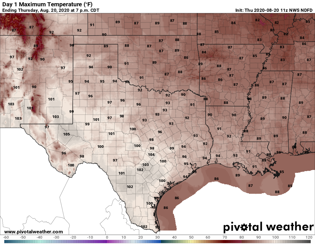
Today’s weather will be a lot like Wednesday’s, which is to say hot and sunny, with high temperatures in the mid- to upper-90s. With slightly drier air in the region, conditions won’t feel quite so humid this morning or this evening, but as an easterly, and southeasterly wind develops this afternoon we’ll feel the beginnings of an onshore flow. A few stray showers may develop near the coast today. Low temperatures will fall into the mid- to upper-70s.
Friday, Saturday, and Sunday
Honestly, we don’t anticipate a whole lot changes with our weather and this August-like pattern, except that the onshore flow will return more humidity at the surface. We’re going to see hot days in the mid-to-upper 90s with oodles of sunshine and only very slight rain chances with coastal counties the most likely areas to see precipitation.
Next week
Our weather next week will depend to a large extent on Invest 97L, but the bottom line is that we may see increasing rain chances by Monday or Monday night. This is probably a good time now to talk tropics.
Invest 97L
This system has become slightly better organized overnight, and forecasters now give 97L high odds of becoming a tropical depression or storm within the next 48 hours as it moves toward the Yucatan Peninsula. Before we talk about the track forecast, it’s important to remember that before a well defined center of circulation forms, overall confidence is low. With that said, probably the most significant change today is that the potential for 97L to take a right-ward turn toward the northern Gulf of Mexico coast is lessening.
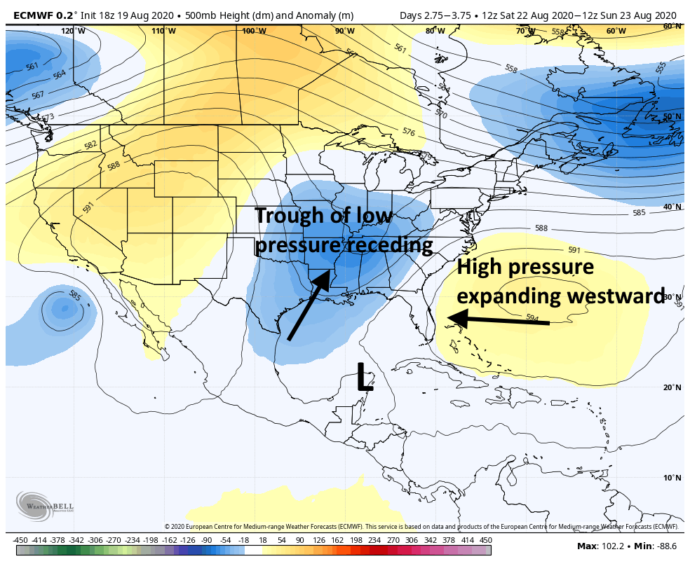
To understand why, here’s a forecast for overall steering currents by this weekend. A high pressure system over the Atlantic will be expanding westward. Meanwhile, a trough of low pressure begins to pull away, to the north. If this trough hangs on long enough, it will pull 97L toward the uppper Texas coast, or Louisiana. If the high pressure system builds faster to the west, it will push 97L into south Texas or Mexico.
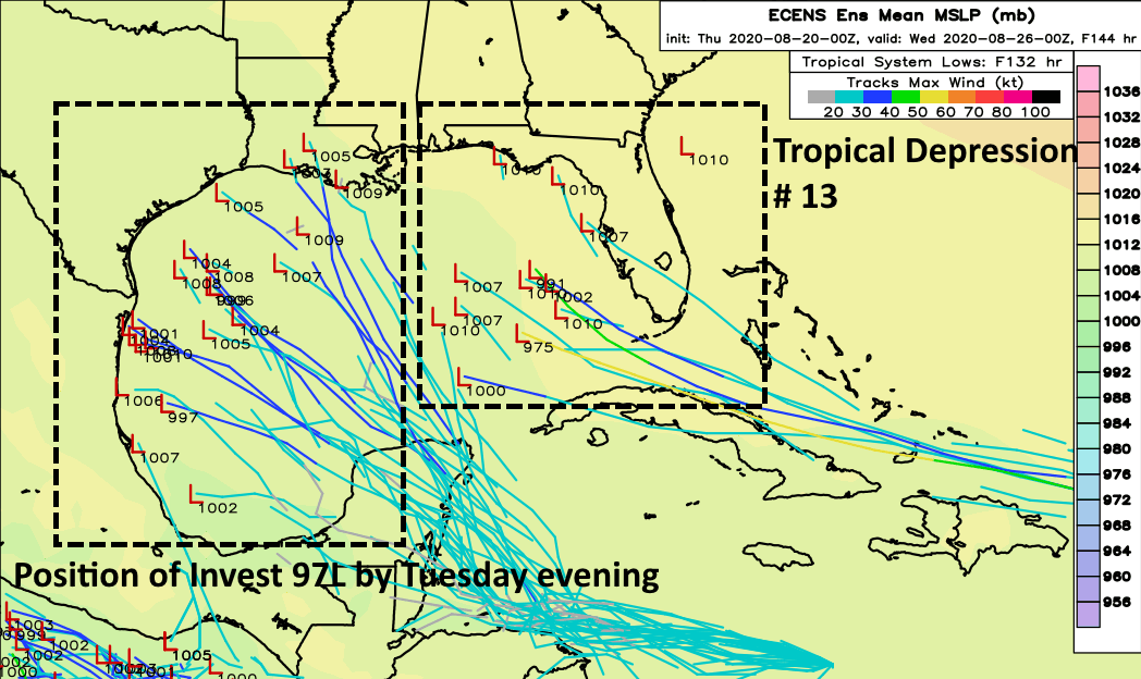
Because of these competing features, and lack of a well defined center, we just don’t have great confidence in track forecasts. However, the global ensembles do seem more confident in a track toward Mexico or Texas next week. Here’s the European model forecast for the position of 97L by Tuesday evening. We’ll talk more about Tropical Depression 13 below, so ignore that for now.
So if Invest 97L may be coming toward Texas or Mexico, how strong will it get? None of the models seem particularly bullish on anything more than a tropical storm, and that is probably because wind shear may be fairly high in the western Gulf of Mexico early next week. Let’s hope for shear, because otherwise the Gulf of Mexico is plenty warm to support strengthening into a strong tropical storm or even a hurricane.
In any case, moisture should begin to arrive in Texas by Monday, leading to elevated rain chances. Beyond this it’s difficult to say much about impacts from 97L given the uncertainty surrounding its track and intensity.
Tropical Depression 13
The system behind Invest 97L became a depression on Wednesday night, and should become a tropical storm within the next day or so. (The next named storm, whether this one or 97L, will be named Laura). This depression is expected to track west-northwest toward Florida this weekend.
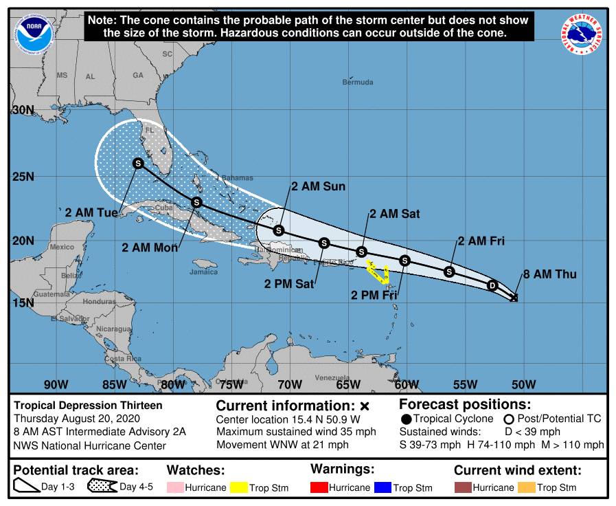
While it probably will be a problem for that state and possibly the eastern Gulf of Mexico, we cannot entirely rule out a more westward track that brings a storm to Texas late next week. But for now it’s probably best to focus on 97L as that has a higher likelihood of affecting Texas.
Do not want.
Won’t the high pressure system steer it more towards Florida?
By it, if you’re talking about 97L, the high would bulge into the GoM, most likely, and guide the storm in a W or WNW direction. The storm would not turn into the high (against the pressure gradient) towards Florida. This assumes the high wins out vs the departing trough, which looks most probable.
Are the dynamics there – post-landfall – to result in either storm stalling along the coast and becoming a huge rainmaker, like Harvey? Or will landfall be a brief event, followed by them moving off into the Plains/South and dissipating?
2 GOM Hurricanes at the same time?? 2020 should have its own museum by now… 0_0
On the Today Show this morning Roker said the last time we had concurrent storms in the GOM was 1959.
Did Eric and Matt forget to mention the swarms of murder hornets detected in the eyes of the storms?
So if I’m planning a trip to the Bolivar Peninsula August 28-30…we should miss these storms, right?
When do you estimate the winds may pick up in Houston? We’ve got trees with dead branches to trim, and loose yard toys. when will we need to have these all secured by?
Why wait? Even if these storms miss this area, we are just now entering the busiest part of the season with more on the horizon.
Late last night and early this morning was quite pleasant outside.
The next month is the peak time we in the Houston area have to worry about tropical storms and hurricanes. Mid-August to mid-September is the time that all of them in recent years, other than Allison, have come.
I’ve been talking to my neighbors an we are very concerned about these storms. With the potential for a one-two punch to our region, do the areas around 99 and the 10 need to take any specific actions? Would Austin or San Antonio be safer?
I like your creative wording!
Anyone who says “the 10” is probably from California or at least somewhere out west.
Hahaha… A while back there was a radio spot airing that said something about “construction on the 290” and I repeatedly screamed at my car radio, “Go back to LA, Cali-dork! No one calls it that here!” Got a lot of looks from other drivers on THE Gulf Freeway.
But then, I usually do.
Anyone familiar with a source or blog that is covering the Florida storm in similar Eric detail? ( family scheduled to travel to FL next weekend). Also thanks for all you do Space City Weather!
Not a Florida blog, but with links to a lot of good data for both storms:
http://www.beaumontweather.com/
Mike’s weather page… He lives in the Tampa Bay area. I’ve been following him for years on Facebook. Great source for Florida weather.
Two questions: Does Covid survive hurricane force winds? Why can’t we just put a big mask on the Texas coast?
My two biggest Qs are: is this an Ike (wind) or Harvey (rain)?
It’s barely an organized system right now. There’s no way to answer that. Even Harvey wasn’t fully solved as a torrential rain-bringer until right before landfall as it was dependent on knowing the upper air patterns over, and to the north of, Texas, that basically blocked it from transiting out of the region.
Am I the only person who sees the Texas Good Coat playing Missile Command?
C’mon, Otto… Texas GULF COAST
/Update/ Oh boy.