It certainly has been awhile, but a damp and stormy weekend is on tap for Southeast Texas. Let’s break it down.
First off, one more hearty thank you to Harmony Strings for sponsoring this site this month!
Today & Saturday
We’ll be quiet for most of the morning today, but clouds will gradually thicken up overhead. Rain showers should begin to break out to our south and west by midday, spreading north and east through afternoon.
A patchwork of scattered showers should be strung out around Houston by the evening commute.
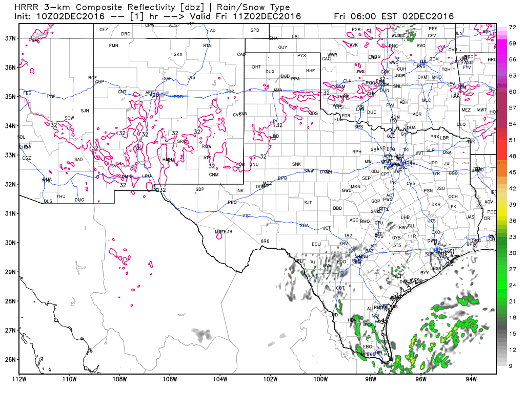
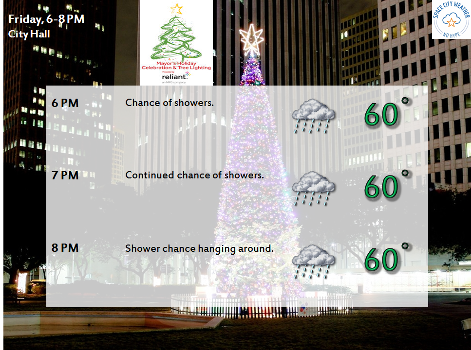
This means that the Christmas tree lighting forecast in Downtown Houston isn’t looking fantastic right now. That said, if the HRRR above is right, we may be able to get it in without too many issues. If you are planning to go, make sure to double check the city’s website or social media feeds.
Periods of rain and perhaps thunderstorms will continue throughout the evening and into the overnight hours. We may see heavier rain along and north of I-10 toward morning. That may pivot toward Houston more tomorrow. Basically, the whole area will see rain, heavy at times, and thunderstorms at various points through the day Saturday.
A forecast caution here: Yes, it will be a stormy couple of days, but it probably will not rain in your neighborhood the whole time. This type of rain will come in fits and starts. Trying to time exactly when and where we see the heaviest rain is exceptionally difficult more than 12 hours in advance with storm systems like this.
Saturday Night Through Monday
Phase two of this system comes Saturday night through Monday. Though it will remain cool and damp, showers and storms should become more hit or miss Saturday night and Sunday morning. Toward Sunday afternoon, as low pressure begins to slowly creep across Texas, we may see a resurgence in heavy rain and storms. It will be at this point that concerns about flash flooding will begin to heighten.
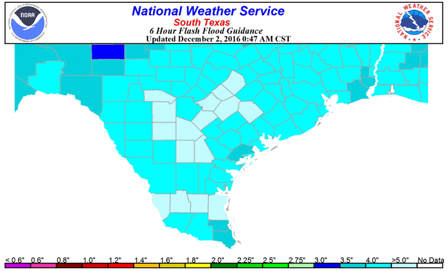
As of Friday morning, the soil can handle a good deal of rain. In fact, up to 4″ over 6 hours can easily be handled before flooding starts, so there are no real serious rainfall flooding concerns for tonight and Saturday.
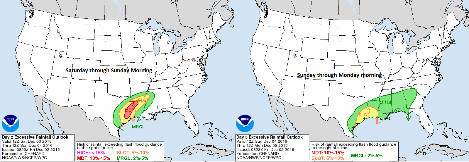
But by Sunday, we’ll likely have exhausted most of this good will, and these flash flood guidance values will drop substantially. So with “round two” of rain Sunday into Monday, flash flooding could be an increasing issue. In fact, the NWS is highlighting our region for a slight to moderate risk of flooding on days 2-3 (Saturday through Monday morning). This product is similar to what you see for severe weather outlooks, so a “moderate” risk in this case means the risk for areas of flash flooding is pretty substantial.
By Sunday night, the rain may ease up a bit for a time. As our storm begins its slow exit later Sunday night and Monday morning, we will likely see a squall line of strong thunderstorms develop west of Houston and eventually push through. Additionally, we’re going to need to watch exactly how things unfold closely. A severe weather threat may exist later Sunday night and Monday, as storms move through, but that depends much on details we can’t quite iron out yet.
By Monday afternoon, this should be out of here, and we can get back to nicer weather. We’re still watching a cold front that could bring widespread low 30s for lows by late next week, and we’ll cover that in more detail after this storm gets through!
So a quick summary: Rain showers develop today and tonight. Rain becomes heavy at times late tonight and tomorrow. There may be some breaks in the rain tomorrow night and early Sunday before more widespread heavy rain develops. The storm will finally exit Monday morning and afternoon. Flash flooding is the biggest concern this weekend, and Flash Flood Watches are likely later today. Severe weather may be a concern Sunday night and Monday especially, but those details are very much TBD.
Eric and I will be with you all weekend covering this. We will have an update for you later today or tomorrow morning and throughout the weekend as needed.
Posted at 6:55 AM by Matt
Thanks guys, it’s good to know you will be keeping an eye on things for us.
Can you comment on the wind and Coastal flooding potential for us Galveston County folks?
Sure. Overwash will be a concern at high tide for some areas of Highway 87 along Bolivar Peninsula through Saturday morning.
Thanks for this information. We are driving to Dallas tonight and plan to return Sunday afternoon/evening. Would you recommend traveling back Sunday morning as opposed to Sunday evening?
My best guess is that you’ll have a better chance of fewer storms on Sunday evening than during the morning hours.
Eric, I sense Deja vu here. Remember the floods of April 18? Tell me we’re not going to go through anything THAT punishing again, please!
Will there be at least tropical storm force winds with this weather regimen?
Not going to be that bad, IMO.
Best forecasts in Houston, thank you both for your work!
Thank you, JS!
Heading to San Antonio Saturday morning. Are these storms staying near the coast or can I expect rain while heading west too? Thanks!
Expect rain in inland areas too, along the drive.
Reassuring to know that you guys are here thru the weekend…true professionals! (Not being snarky…I mean it)…