In brief: We are maintaining a Stage 1 flood alert today due to the potential for street flooding from showers and thunderstorms. Hopefully we’ll start to see a break in the action this afternoon. Conditions turn hot and sunny by this weekend, and then we should stay in that pattern for awhile.
Storm overview
Nearly all of the Houston metro area picked up at least some rainfall on Monday and Monday night, and much of the area received in excess of 1 inch. We will continue to see surging atmospheric moisture levels today, and accordingly the Houston-area radar will get another workout. The action is getting started earlier today than on Monday, with showers already having spread into much of the region.
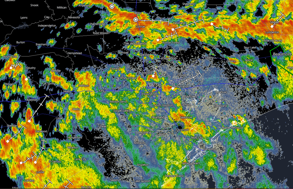
Basically we can expect fairly widespread showers and thunderstorms to persist through this morning, bringing an additional 1 to 2 inches of rainfall to most locations. It is possible that some locations see bullseyes of 3 or more inches of rainfall, which is why we have kept a Stage 1 flood alert in place for today and tonight. This means you should be aware of the potential for street flooding, and pay attention to the radar before venturing out. It also means that for most of the area most of the time, these showers are more of a nuisance than a serious hindrance to going about your business. Unless your business is house painting.
After this morning we expect there to be something of a reprieve this afternoon and this evening. An additional round of showers, likely not as intense nor as widespread, is possible on Wednesday.
Tuesday
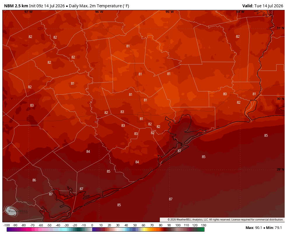
As mentioned above, it’s raining. These showers and thunderstorms should be most widespread this morning before activity tapers off this afternoon to scattered, or possibly even isolated thunderstorms. Even when it’s not raining, skies should be mostly cloudy today, and high temperatures are likely to peak in the lower 80s. This is going to be one of the “coldest” days of the summer in Houston, with air temperatures for most of the day in the 70s. We don’t experience that often in the middle of the summer, so it’s a bit of silver lining to the rain. (Another silver lining is that next week looks rather hot and sunny, so the rains were getting now set us up nicely for that period). Showers will ease this afternoon and tonight should be mostly rain-free, with lows in the mid-70s.
Wednesday
We’re going to see another chance of showers on Wednesday, including a few stronger thunderstorms. But instead of a 100 percent chance of rain, the overall likelihood is more like 50 percent, and storms should persist for less time. Skies should remain mostly cloudy, and this will help keep highs in the mid- to upper-80s.
Thursday
Skies will still be fairly cloudy on Thursday, although we probably will start to see some breaks in the clouds. This will allow highs to reach about 90 degrees. Could we squeeze out a few additional showers? Possibly, but by this point we’re likely to begin to see the influence of high pressure tamping down rain chances. Lows on Thursday night will only fall into the upper 70s.
Friday
Expect a partly sunny day with highs in the low- to mid-90s. Rain chances are pretty much gone.
Saturday and Sunday
The weekend looks set to bring us mostly sunny to sunny skies, with highs in the mid- to upper 90s. We have no weather concerns aside from the heat and of course the potential for sunburns from mid-morning through late afternoon.
Next week
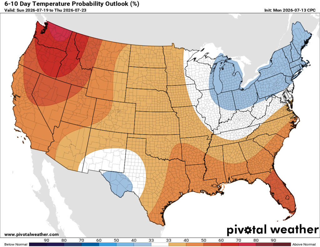
We are going to continue to see hot and sunny weather, with highs in the mid- to upper-90s for all locations but coastal areas, which will be a touch cooler. Rain chances are basically zero until the middle of the week, by which point we may see something like a 10 percent chance of showers. It’s late July in Houston, folks, and it’s going to feel like it.
