We’ve gotten into quite a groove lately with repeating rounds of cold fronts pushing through the Houston area. Since the beginning of November, I count about 13, give or take, individual cold frontal passages here in Houston. That’s about one every 3 to 4 days on average, although after some warmth in November the pace has accelerated in recent weeks. In fact, this is the first time since 2011 that we have not hit 80 degrees in the month of December at least once to this point. If you keep cold fronts coming at a quick pace, you really tend to cap how warm we can get in between. So this has been good for us in terms of keeping temperatures closer to normal for this time of year. And we have one, likely two more fronts coming over the next week.
Today & Saturday
It’s another chilly start to the day across the region. As of 6:45 AM, we had 30s north and 40s south (50s along the coast).
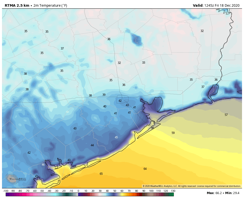
Bush Airport officially hit 35° this morning, but that was around 4 AM, and as some cloud cover has pushed into the area, temps have risen a few degrees. Skies should get progressively more cloudy today. Even with those clouds, we should be able to punch through the 50s and into the 60s later today, as building onshore flow pumps in warmer, more humid air. Some light rain or drizzle and mist will be possible along the coast and south of Houston by late afternoon or evening.
Overnight, we continue to see humidity build up, which should allow temperatures to either hold where they are or even warm a bit. No 30s tomorrow morning! Showers and patches of fog, mist, or light rain should begin to break out across the area tonight as well.
For Saturday, a period of showers and thunderstorms will be likely as a cold front begins to approach around late morning or early afternoon. Tomorrow should not be a total washout, but the majority of the morning looks unpleasant. Rain should shut off from west to east during the afternoon, though some of it could be heavy before it does so.
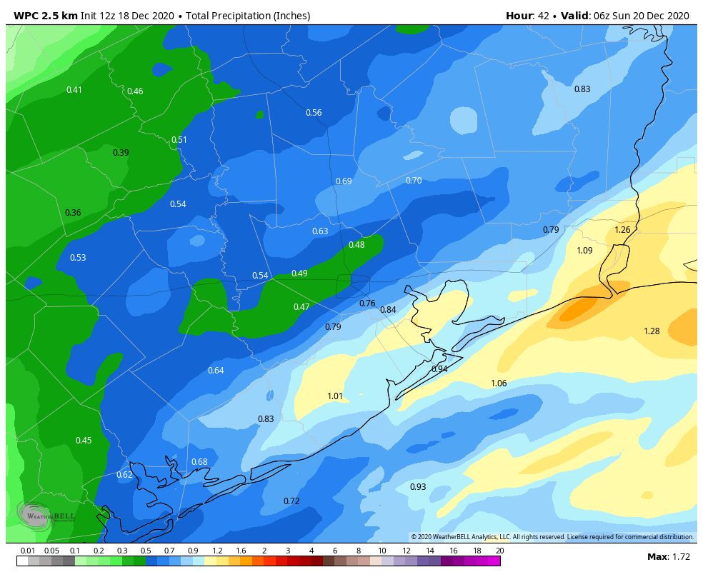
How much rain are we talking? Probably a half-inch or so on average. Some locations, especially east of I-45 could see higher totals with as much as 1.5 inches or so possible near Beaumont and Lake Charles. A few locations, especially west of the city may see less than a half-inch. Skies should begin to at least partially clear on Saturday evening.
Temperatures will top off near 70° before dropping back into the 60s or upper-50s during the afternoon behind the front.
Sunday & Monday
Look for nice weather to slowly emerge after Saturday. Sunday should see morning lows in the 40s for most folks. Low clouds may remain stuck over the area into Sunday morning, but by Sunday afternoon we should see clearing and sunshine. Look for 10 to 15 mph winds, and high temperatures on Sunday peaking in the low-60s.
We will see lows in the 30s and 40s Sunday night into Monday morning, followed up by a nice sun-filled day Monday with highs in the 60s. Some high clouds could begin to gray the sky a bit by Monday afternoon, especially south and west of Houston.
Tuesday
Tuesday should end up being partly to mostly sunny and warmer, with temperatures starting the day in the 40s and lower 50s and afternoon highs in the 60s, perhaps near 70° in some spots. Some clouds could gradually creep back in through the day.
Wednesday & Christmas Eve/Day
We’re continuing to gain confidence that a cold front is indeed going to come through the area before Christmas Eve. This likely means at least some showers on Wednesday. The timing of the front may have sped up some since yesterday, with some models getting it through Houston on Wednesday afternoon now. There seems to be an increasing chance that both Christmas Eve and Christmas Day will feature sunshine, morning lows in the 30s or 40s, and daytime highs in the 50s. Winds will likely be a bit gusty on Christmas Eve, but they should settle down Thursday night, allowing Santa and his reindeer to have a smooth flight into Southeast Texas. We will have more on this for you Monday.

“In fact, this is the first time since 2011 that we have not hit 80 degrees in the month of December at least once to this point.”
AND IT’S GLORIOUS!!!!!!!!
We are off 610 and Ella and planing a hayride Saturday evening. Should the rain have stopped around 5/630 or should we try and reschedule? Thanks!
Think you’ll be good on Saturday evening!
Is the hayride going to be at the Lowe’s?
Are you saying that we’ll not be able to see the conjunction (near the horizon, near the sunset), in the 45 minutes right after sunset due to clouds?
I wouldn’t say the chances are 0%, but they’re pretty low today I would think.
Sorry, I meant for Monday night.
Ah…well it’s a bit early, but I would say chances are at least 50/50 or better that it’ll be clear enough. Fingers crossed!
I love the steady stream of cold fronts – keep them coming!
And, I’m glad to hear that Festivus may usher in a good cold front. The airing of grievances are best done outside this particular year.
We have a outdoor family gathering planned for Wednesday evening, will the wind be gusty like last Sunday when the front pushes through?
Far too soon to really say, but there is a chance it could be, yes.
After the prediction for a warmer than normal and drier than normal fall and winter, it seems that the weather has been closer to normal. So much for the prediction. It is critical that we have warm weather so that we can be outdoors and not have a rise in cases.
Apart from some rain, the weather this December has been fantastic! Certainly none of that 84 and humid on Christmas stuff we’ve seen in recent years. It’s the one positive I have been able to put on an otherwise rather crappy Advent season.
There’s just one thing missing, Eric, and Matt. We need some S N O W. Can you guys pull it off in the remaining two weeks of the month? Thanks in advance.
Fully agree there, Blackhawks fan.. But man, don’t get greedy asking Eric & Matt for snow too.. This splendidly cool December for true holiday feel is more than enough for me! That said, if they possibly could pull off that snow deal….
none of that 84 and humid on Christmas stuff”
I’d settle for 80. And a Festivus Margarita…