In brief: In today’s post we provide an overview of Houston’s rain chances over the next four days, which will be elevated. Although there’s the potential for some heavy rain, we’re not too concerned about flooding at this time. A modest cool front arrives early next week.
Wet pattern overview
An upper-level low, in concert with the remains of Hurricane Polo, is bringing heavy rains to the Texas Hill Country this morning, and these storms are moving toward the I-35 corridor. This system will progress eastward across Texas, but it should stall later today to the west of Houston, near the Brazos Valley. Several inches of rain are possible from this system in Central Texas, but the Houston region should not see major effects aside from the potential for scattered showers and thunderstorms today.
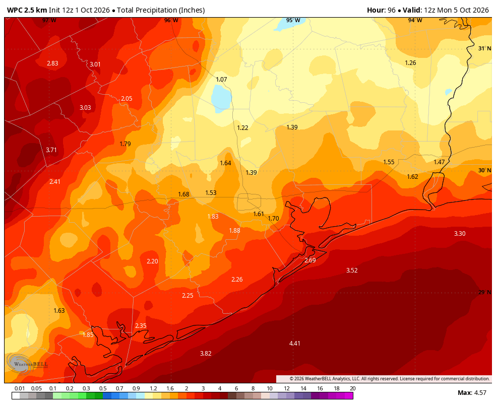
For us, the best rain chances will come from Friday evening through Sunday morning as a weak frontal boundary slowly trudges through the area and stalls near the coast. With ample moisture this setup will bring the potential for heavy rainfall into the region during this time period, especially along the slow-moving boundary. Whether this rain falls just inland, or off the coast, will depend on precisely where the boundary stalls. All in all, through Sunday, most of the Houston region should pick up 1 to 4 inches of rain. We are not planning to issue a flood stage warning on our flood scale at this time, but we will continue to monitor things closely.
Quick space note

Weather permitting, four astronauts will launch to the International Space Station this morning aboard a Crew Dragon spacecraft from Florida. The crew includes NASA astronauts Jessica Watkins and Luke Delaney, Canadian astronaut Josh Kutryk, and Russian cosmonaut Sergey Teteryatnikov. Launch is set for 10:10am for this Crew-13 mission. We wanted to send a special shoutout to Kutryk, a fan of Space City Weather! Safe travels to all.
Thursday
The last day of September was another hot one, with high temperatures in the mid-90s for inland areas of Houston. Phew! Highs should peak in the lower 90s today across the city, and then after today or Friday, we should be able to say sayonara to the 90s for awhile. As noted above, the heavy rainfall due to Polo’s remnants should stay west of Harris and surrounding counties. However we will see scattered to widespread showers today, and the heaviest cells may quickly produce 1 or 2 inches of rain in isolated areas. Most locations will see considerably less, however. We’ll see some gusty southerly winds again later today. Overnight lows will drop into the upper 70s, and rain chances will slacken, but not go away entirely.
Friday, Saturday, and Sunday
It will be a soggy weekend, yes. But at the same time it’s not going to rain everywhere, all the time. There will definitely be breaks in the showers, so if you’re planning to attend a festival, or a college football game, or something else, do not abandon all hope. Nevertheless our region will see its best rain chances in weeks, and there will be more clouds than sunshine. Rain totals will vary widely, but most areas should get 1 to 4 inches. What concerns me most is the potential for these showers, tropical in nature, to produce briefly heavy rainfall. But again, aside from possibly the immediate coast, we don’t expect too much of that behavior over the Houston region. If our expectations change, of course, we’ll update here. Temperatures will gradually push downward, with highs in the upper 80s on Friday dropping to the mid-80s on Sunday, and overnight lows going from the upper 70s to lower 70s.
Next week
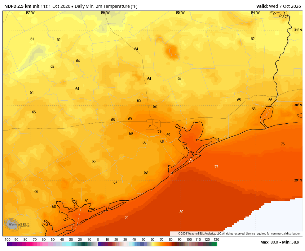
A slightly stronger cool front is really in the cards for early next week, likely arriving Monday night. This should lead us to sunny days in the 80s for most of next week, with nights in the 60s or lower 70s. Humidity will be lower, but as this is still one of our early fronts don’t expect miracles on that score. Still, it won’t be Houston-like houmidity, and after our long summer it’s going to feel fairly pleasant out there. Just don’t expect sweater weather just yet.
Tropics
You may start to see some noise about tropical development in the Southern Gulf or Bay of Campeche next week, and some of our models are showing the potential for modest development there. We don’t have any real concerns about this in Texas, however, as any systems that develop there next week will most likely move to the northeast, away from the state.
